Bridge Statistics for Locust Grove, Oklahoma (OK)
Condition, Traffic, Stress, Structural Evaluation, Project Costs
- National Bridge Inventory (NBI) Statistics
- 14Number of bridges
- 98ft / 29.9mTotal length
- $15,037,000Total costs
- 71,900Total average daily traffic
- 15,127Total average daily truck traffic
- National Bridge Inventory (NBI) Registered Bridges for Locust Grove
- No street view available for this location
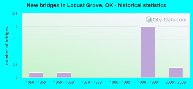
- New bridges - historical statistics
- 11950-1959
- 11960-1969
- 101990-1999
- 22000-2009


- Bridge Condition - Deck
- 80.0%Good
- 20.0%Fair

- Bridge Condition - Superstructure
- 80.0%Very good
- 20.0%Fair

- Bridge Condition - Substructure
- 80.0%Good
- 20.0%Serious

- Bridge Condition - Channel
- 33.3%Very good
- 50.0%Good
- 16.7%Fair

- Bridge Condition - Culverts
- 60.0%Very good
- 20.0%Good
- 20.0%Satisfactory
Find on map >> Show street view
Structure Number: 11178, Location: WYANDOTTE ST. IN LOCGRO (Lat: 36.199731, Lng: -95.172292), Route carried "on" structure: County highway N4400, Year Built: 1950, Status: Posted for load, Structure Length: 0.70m (2.30ft), Average Daily Traffic: 950 (year 2020), Truck Traffic: 10%, Average Future Daily Traffic: 1,520 (year 2040), Design Load: H 20, Features Intersected: CREEK
Minimum Vertical Clearance: 30+ m (98+ ft), Kilometerpoint: 0.483, Lanes on structure: 2, Owner: County Highway Agency, Approaching Roadway Width: 5.5m (18.0ft), Skew: 2 degrees, Material/Design: Concrete continuous, Design/Construction: Slab, Number Of Spans In Main Unit: 2, Length of Maximum Span: 3.4m (11.2ft), Curb-To-Curb Width: 5.2m (17.1ft), Out-to-Out Width: 6.0m (19.7ft)
Condition: Deck: Fair, Superstructure: Fair, Substructure: Serious, Channel: Fair, Operating Rating: 21.8 metric tons, Method Used To Determine Operating Rating: Load Factor (LF), Inventory Rating: 13.1 metric tons, Method Used To Determine Inventory Rating: Load Factor (LF), Structural Evaluation: High priority of corrective action, Waterway Adequacy: Equal to present minimum criteria, Approach Roadway Alignment: Better than present minimum criteria, Bridge Posting: Required (Relationship of Operating Rating to Maximum Legal Load: 30.0 - 39.9% below), Length Of Structure Improvement: 2.86m (9.38ft), Designated Inspection Frequency: Every 24 months, Other Special Inspection Frequency: Every 24 months, Inspection Date: March 2021, Other Special Inspection Date: March 2021, Bridge Improvement Cost: $146,000, Roadway Improvement Cost: $80,000, Total Project Cost: $230,000 ( Estimate for 2015), Deck Structure Type: Concrete Cast-file-Place, Wearing Surface/Protective System: Wearing Surface: Bituminous
Find on map >> Show street view
Structure Number: 16675, Location: 0.1 MI N JCT US 412 (Lat: 36.201256, Lng: -95.158969), Route carried "on" structure: State highway 82, Year Built: 1966, Status: Open, Structure Length: 1.01m (3.31ft), Average Daily Traffic: 4,000 (year 2020), Truck Traffic: 15%, Average Future Daily Traffic: 6,400 (year 2040), Design Load: HS 20, Features Intersected: CREEK
Minimum Vertical Clearance: 30+ m (98+ ft), Kilometerpoint: 0.129, Lanes on structure: 2, Owner: State Highway Agency, Approaching Roadway Width: 12.2m (40.0ft), Material/Design: Concrete, Design/Construction: Culvert, Number Of Spans In Main Unit: 3, Length of Maximum Span: 3.0m (9.8ft)
Condition: Channel: Good, Culverts: Satisfactory, Operating Rating: 38.8 metric tons, Method Used To Determine Operating Rating: Load Factor (LF), Inventory Rating: 23.3 metric tons, Method Used To Determine Inventory Rating: Load Factor (LF), Structural Evaluation: Equal to present minimum criteria, Waterway Adequacy: Equal to present desirable criteria, Approach Roadway Alignment: Equal to present desirable criteria, Length Of Structure Improvement: 1.01m (3.31ft), Designated Inspection Frequency: Every 24 months, Inspection Date: April 2021, Bridge Improvement Cost: $230,000, Roadway Improvement Cost: $380,000, Total Project Cost: $644,000 ( Estimate for 2015)
Find on map >> Show street view
Structure Number: 22751, Location: 5.85 MI.NE OF TP GATE (Lat: 36.185472, Lng: -95.174372), Route carried "on" structure: Other road 412, Year Built: 1991, Status: Open, Structure Length: 1.13m (3.71ft), Average Daily Traffic: 9,400 (year 2020), Truck Traffic: 25%, Average Future Daily Traffic: 15,040 (year 2040), Design Load: HS 20, Features Intersected: CREEK, Facility Carried by Structure: CHEROKEE TP
Minimum Vertical Clearance: 30+ m (98+ ft), Kilometerpoint: 13.984, Lanes on structure: 4, Base Highway Network: Yes, Toll: On toll road, Owner: State Toll Authority, Approaching Roadway Width: 33.2m (108.9ft), Skew: 12 degrees, Material/Design: Concrete, Design/Construction: Culvert, Number Of Spans In Main Unit: 3, Length of Maximum Span: 3.0m (9.8ft), Curb-To-Curb Width: 48.3m (158.5ft), Out-to-Out Width: 49.0m (160.8ft)
Condition: Channel: Very good, Culverts: Very good, Operating Rating: 44.5 metric tons, Method Used To Determine Operating Rating: Allowable Stress (AS), Inventory Rating: 32.7 metric tons, Method Used To Determine Inventory Rating: Allowable Stress (AS), Structural Evaluation: Equal to present desirable criteria, Deck Geometry: Superior to present desirable criteria, Waterway Adequacy: Equal to present desirable criteria, Approach Roadway Alignment: Equal to present desirable criteria, Length Of Structure Improvement: 3.58m (11.75ft), Designated Inspection Frequency: Every 24 months, Inspection Date: September 2020, Bridge Improvement Cost: $200,000, Roadway Improvement Cost: $150,000, Total Project Cost: $360,000 ( Estimate for 2015)
Find on map >> Show street view
Structure Number: 22775, Location: 5.03 MI.NE OF TP GATE (Lat: 36.183936, Lng: -95.188683), Route carried "on" structure: Other road 412, Year Built: 1991, Status: Open, Structure Length: 1.43m (4.69ft), Average Daily Traffic: 9,400 (year 2020), Truck Traffic: 25%, Average Future Daily Traffic: 15,040 (year 2040), Design Load: HS 20, Features Intersected: CREEK, Facility Carried by Structure: CHEROKEE TP
Minimum Vertical Clearance: 30+ m (98+ ft), Kilometerpoint: 11.885, Lanes on structure: 4, Base Highway Network: Yes, Toll: On toll road, Owner: State Toll Authority, Approaching Roadway Width: 33.2m (108.9ft), Skew: 11 degrees, Material/Design: Concrete, Design/Construction: Culvert, Number Of Spans In Main Unit: 3, Length of Maximum Span: 5.2m (17.1ft), Curb-To-Curb Width: 55.3m (181.4ft), Out-to-Out Width: 55.9m (183.4ft)
Condition: Channel: Good, Culverts: Very good, Operating Rating: 44.5 metric tons, Method Used To Determine Operating Rating: Allowable Stress (AS), Inventory Rating: 32.7 metric tons, Method Used To Determine Inventory Rating: Allowable Stress (AS), Structural Evaluation: Equal to present desirable criteria, Deck Geometry: Superior to present desirable criteria, Waterway Adequacy: Equal to present desirable criteria, Approach Roadway Alignment: Equal to present desirable criteria, Length Of Structure Improvement: 4.35m (14.27ft), Designated Inspection Frequency: Every 24 months, Inspection Date: September 2020, Bridge Improvement Cost: $200,000, Roadway Improvement Cost: $150,000, Total Project Cost: $360,000 ( Estimate for 2015)
Find on map >> Show street view
Structure Number: 22876, Location: 6.65 MI N OF CHEROKEE C/L (Lat: 36.187806, Lng: -95.159703), Route carried "on" structure: Other road 412, Year Built: 1991, Status: Open, Structure Length: 5.49m (18.01ft), Average Daily Traffic: 3,050 (year 2020), Truck Traffic: 25%, Average Future Daily Traffic: 4,880 (year 2040), Design Load: HS 20, Features Intersected: S.H. 82 UNDER, Facility Carried by Structure: CHEROKEE TP
Minimum Vertical Clearance: 30+ m (98+ ft), Kilometerpoint: 16.209, Lanes on structure: 2, Lanes under structure: 2, Base Highway Network: Yes, Toll: On toll road, Owner: State Toll Authority, Approaching Roadway Width: 12.2m (40.0ft), Skew: 12 degrees, Material/Design: Prestressed concrete continuous, Design/Construction: Stringer/Multi-beam, Number Of Spans In Main Unit: 3, Length of Maximum Span: 28.7m (94.2ft), Curb-To-Curb Width: 12.2m (40.0ft), Out-to-Out Width: 12.8m (42.0ft)
Condition: Deck: Good, Superstructure: Very good, Substructure: Good, Operating Rating: 44.5 metric tons, Method Used To Determine Operating Rating: Load Factor (LF), Inventory Rating: 32.7 metric tons, Method Used To Determine Inventory Rating: Load Factor (LF), Structural Evaluation: Better than present minimum criteria, Deck Geometry: Better than present minimum criteria, Underclear: Superior to present desirable criteria, Approach Roadway Alignment: Equal to present desirable criteria, Length Of Structure Improvement: 8.10m (26.57ft), Designated Inspection Frequency: Every 24 months, Inspection Date: September 2020, Bridge Improvement Cost: $1,054,000, Roadway Improvement Cost: $1,581,000, Total Project Cost: $3,006,000 ( Estimate for 2015), Deck Structure Type: Concrete Cast-file-Place, Wearing Surface/Protective System: Wearing Surface: Monolithic Concrete, Deck Protection: Epoxy Coated Reinforcing
Find on map >> Show street view
Structure Number: 22887, Location: 5.20 MI.NE OF TP GATE (Lat: 36.184300, Lng: -95.185792), Route carried "on" structure: County highway , Year Built: 1991, Status: Open, Structure Length: 6.14m (20.14ft), Average Daily Traffic: 5,000 (year 2020), Truck Traffic: 15%, Average Future Daily Traffic: 8,000 (year 2040), Design Load: HS 20, Features Intersected: CHEROKEE TP UNDER, Facility Carried by Structure: CO. RD. N4393
Minimum Vertical Clearance: 30+ m (98+ ft), Kilometerpoint: 8.367, Lanes on structure: 2, Lanes under structure: 4, Owner: State Toll Authority, Approaching Roadway Width: 9.1m (29.9ft), Skew: 1 degrees, Material/Design: Prestressed concrete continuous, Design/Construction: Stringer/Multi-beam, Number Of Spans In Main Unit: 2, Length of Maximum Span: 30.5m (100.1ft), Curb-To-Curb Width: 9.1m (29.9ft), Out-to-Out Width: 9.8m (32.2ft)
Condition: Deck: Good, Superstructure: Very good, Substructure: Good, Operating Rating: 41.1 metric tons, Method Used To Determine Operating Rating: Load Factor (LF), Inventory Rating: 24.6 metric tons, Method Used To Determine Inventory Rating: Load Factor (LF), Structural Evaluation: Equal to present minimum criteria, Deck Geometry: Meets minimum limits, Underclear: Equal to present minimum criteria, Approach Roadway Alignment: Equal to present desirable criteria, Length Of Structure Improvement: 6.76m (22.18ft), Designated Inspection Frequency: Every 24 months, Inspection Date: September 2020, Bridge Improvement Cost: $762,000, Roadway Improvement Cost: $1,143,000, Total Project Cost: $2,179,000 ( Estimate for 2015), Deck Structure Type: Concrete Cast-file-Place, Wearing Surface/Protective System: Wearing Surface: Monolithic Concrete, Deck Protection: Epoxy Coated Reinforcing
Find on map >> Show street view
Structure Number: 22888, Location: 5.96 MI.NE OF TP GATE (Lat: 36.185372, Lng: -95.172331), Route carried "on" structure: County highway , Year Built: 1991, Status: Open, Structure Length: 6.14m (20.14ft), Average Daily Traffic: 5,000 (year 2020), Truck Traffic: 15%, Average Future Daily Traffic: 8,000 (year 2040), Design Load: HS 20, Features Intersected: CHEROKEE TP UNDER, Facility Carried by Structure: CO. RD. N4400
Minimum Vertical Clearance: 30+ m (98+ ft), Kilometerpoint: 9.590, Lanes on structure: 2, Lanes under structure: 4, Owner: State Toll Authority, Approaching Roadway Width: 9.1m (29.9ft), Skew: 1 degrees, Material/Design: Prestressed concrete continuous, Design/Construction: Stringer/Multi-beam, Number Of Spans In Main Unit: 2, Length of Maximum Span: 30.5m (100.1ft), Curb-To-Curb Width: 9.1m (29.9ft), Out-to-Out Width: 9.8m (32.2ft)
Condition: Deck: Good, Superstructure: Very good, Substructure: Good, Operating Rating: 41.1 metric tons, Method Used To Determine Operating Rating: Load Factor (LF), Inventory Rating: 24.6 metric tons, Method Used To Determine Inventory Rating: Load Factor (LF), Structural Evaluation: Equal to present minimum criteria, Deck Geometry: Meets minimum limits, Underclear: Equal to present minimum criteria, Approach Roadway Alignment: Equal to present desirable criteria, Length Of Structure Improvement: 6.76m (22.18ft), Designated Inspection Frequency: Every 24 months, Inspection Date: September 2020, Bridge Improvement Cost: $762,000, Roadway Improvement Cost: $1,143,000, Total Project Cost: $2,179,000 ( Estimate for 2015), Deck Structure Type: Concrete Cast-file-Place, Wearing Surface/Protective System: Wearing Surface: Monolithic Concrete, Deck Protection: Epoxy Coated Reinforcing
Find on map >> Show street view
Structure Number: 23131, Location: 6.65 MI N OF CHEROKEE C/L (Lat: 36.188133, Lng: -95.159650), Route carried "on" structure: Other road 412, Year Built: 1991, Status: Open, Structure Length: 5.49m (18.01ft), Average Daily Traffic: 3,300 (year 2020), Truck Traffic: 25%, Average Future Daily Traffic: 5,280 (year 2040), Design Load: HS 20, Features Intersected: S.H. 82 UNDER, Facility Carried by Structure: CHEROKEE TP
Minimum Vertical Clearance: 30+ m (98+ ft), Kilometerpoint: 16.209, Lanes on structure: 2, Lanes under structure: 2, Base Highway Network: Yes, Toll: On toll road, Owner: State Toll Authority, Approaching Roadway Width: 12.2m (40.0ft), Skew: 12 degrees, Material/Design: Prestressed concrete continuous, Design/Construction: Stringer/Multi-beam, Number Of Spans In Main Unit: 3, Length of Maximum Span: 28.7m (94.2ft), Curb-To-Curb Width: 12.2m (40.0ft), Out-to-Out Width: 12.8m (42.0ft)
Condition: Deck: Good, Superstructure: Very good, Substructure: Good, Operating Rating: 44.5 metric tons, Method Used To Determine Operating Rating: Load Factor (LF), Inventory Rating: 32.7 metric tons, Method Used To Determine Inventory Rating: Load Factor (LF), Structural Evaluation: Better than present minimum criteria, Deck Geometry: Better than present minimum criteria, Underclear: Superior to present desirable criteria, Approach Roadway Alignment: Equal to present desirable criteria, Length Of Structure Improvement: 8.10m (26.57ft), Designated Inspection Frequency: Every 24 months, Inspection Date: September 2020, Bridge Improvement Cost: $1,054,000, Roadway Improvement Cost: $1,581,000, Total Project Cost: $3,006,000 ( Estimate for 2015), Deck Structure Type: Concrete Cast-file-Place, Wearing Surface/Protective System: Wearing Surface: Monolithic Concrete, Deck Protection: Epoxy Coated Reinforcing
Find on map >> Show street view
Structure Number: 25492, Location: 5.7 MI E OF TURNPIKE (Lat: 36.195597, Lng: -95.172506), Route carried "on" structure: Alternate US 412A, Year Built: 2001, Status: Open, Structure Length: 1.62m (5.31ft), Average Daily Traffic: 2,900 (year 2020), Truck Traffic: 15%, Average Future Daily Traffic: 4,640 (year 2040), Design Load: HL 93, Features Intersected: CREEK, Facility Carried by Structure: U.S. 412 ALT.
Minimum Vertical Clearance: 30+ m (98+ ft), Kilometerpoint: 14.785, Lanes on structure: 2, Owner: State Highway Agency, Approaching Roadway Width: 12.2m (40.0ft), Material/Design: Concrete, Design/Construction: Culvert, Number Of Spans In Main Unit: 3, Length of Maximum Span: 4.9m (16.1ft)
Condition: Channel: Good, Culverts: Very good, Operating Rating: 88.5 metric tons, Method Used To Determine Operating Rating: Load and Resistance Factor (LRFR), Inventory Rating: 53.1 metric tons, Method Used To Determine Inventory Rating: Load and Resistance Factor (LRFR), Structural Evaluation: Equal to present desirable criteria, Waterway Adequacy: Equal to present desirable criteria, Approach Roadway Alignment: Better than present minimum criteria, Length Of Structure Improvement: 1.62m (5.31ft), Designated Inspection Frequency: Every 24 months, Inspection Date: April 2021, Bridge Improvement Cost: $278,000, Roadway Improvement Cost: $459,000, Total Project Cost: $778,000 ( Estimate for 2015)
Find on map >> Show street view
Structure Number: 26404, Location: .2W .4N .5W LOCUST GROVE (Lat: 36.205417, Lng: -95.180500), Route carried "on" structure: County highway E0560, Year Built: 2000, Status: Open, Structure Length: 0.70m (2.30ft), Average Daily Traffic: 100 (year 2020), Truck Traffic: 10%, Average Future Daily Traffic: 200 (year 2040), Design Load: HS 20, Features Intersected: TRIBUTARY OF CRUTCHFIEL, Facility Carried by Structure: Business City street
Minimum Vertical Clearance: 30+ m (98+ ft), Kilometerpoint: 0.805, Lanes on structure: 2, Owner: County Highway Agency, Approaching Roadway Width: 7.9m (25.9ft), Skew: 3 degrees, Material/Design: Concrete, Design/Construction: Culvert, Number Of Spans In Main Unit: 2, Length of Maximum Span: 3.0m (9.8ft)
Condition: Channel: Very good, Culverts: Good, Operating Rating: 55.3 metric tons, Method Used To Determine Operating Rating: Load Factor (LF), Inventory Rating: 33.2 metric tons, Method Used To Determine Inventory Rating: Load Factor (LF), Structural Evaluation: Better than present minimum criteria, Waterway Adequacy: Better than present minimum criteria, Approach Roadway Alignment: Equal to present desirable criteria, Length Of Structure Improvement: 3.05m (10.01ft), Designated Inspection Frequency: Every 24 months, Inspection Date: March 2021, Bridge Improvement Cost: $1,062,000, Roadway Improvement Cost: $1,205,000, Total Project Cost: $2,295,000 ( Estimate for 2015)
Find on map >> Show street view
Structure Number: 22876, Location: 6.65 MI N OF CHEROKEE C/L (Lat: 36.187806, Lng: -95.159703), Route carried "under" structure: State highway 82, Year Built: 1991, Structure Length: 0. m, Average Daily Traffic: 5,000 (year 2020), Truck Traffic: 15%, Features Intersected: S.H. 82 UNDER, Facility Carried by Structure: CHEROKEE TP
Minimum Vertical Clearance: 5.64m (18.50ft), Kilometerpoint: 11.133, Lanes on structure: 2, Lanes under structure: 2, Material/Design: Prestressed concrete continuous, Design/Construction: Stringer/Multi-beam, Length of Maximum Span: 28.7m (94.2ft)
Find on map >> Show street view
Structure Number: 22887, Location: 5.20 MI.NE OF TP GATE (Lat: 36.184300, Lng: -95.185792), Route carried "under" structure: Other road 412, Year Built: 1991, Structure Length: 0. m, Average Daily Traffic: 9,400 (year 2020), Truck Traffic: 25%, Features Intersected: CHEROKEE TP UNDER, Facility Carried by Structure: CO. RD. N4393
Minimum Vertical Clearance: 5.16m (16.93ft), Kilometerpoint: 8.367, Lanes on structure: 2, Lanes under structure: 4, Toll: On toll road, Material/Design: Prestressed concrete continuous, Design/Construction: Stringer/Multi-beam, Length of Maximum Span: 30.5m (100.1ft)
Find on map >> Show street view
Structure Number: 22888, Location: 5.96 MI.NE OF TP GATE (Lat: 36.185372, Lng: -95.172331), Route carried "under" structure: Other road 412, Year Built: 1991, Structure Length: 0. m, Average Daily Traffic: 9,400 (year 2020), Truck Traffic: 25%, Features Intersected: CHEROKEE TP UNDER, Facility Carried by Structure: CO. RD. N4400
Minimum Vertical Clearance: 4.90m (16.08ft), Kilometerpoint: 9.590, Lanes on structure: 2, Lanes under structure: 4, Toll: On toll road, Material/Design: Prestressed concrete continuous, Design/Construction: Stringer/Multi-beam, Length of Maximum Span: 30.5m (100.1ft)
Find on map >> Show street view
Structure Number: 23131, Location: 6.65 MI N OF CHEROKEE C/L (Lat: 36.188133, Lng: -95.159650), Route carried "under" structure: State highway 82, Year Built: 1991, Structure Length: 0. m, Average Daily Traffic: 5,000 (year 2020), Truck Traffic: 15%, Features Intersected: S.H. 82 UNDER, Facility Carried by Structure: CHEROKEE TP
Minimum Vertical Clearance: 5.28m (17.32ft), Kilometerpoint: 11.166, Lanes on structure: 2, Lanes under structure: 2, Material/Design: Prestressed concrete continuous, Design/Construction: Stringer/Multi-beam, Length of Maximum Span: 28.7m (94.2ft)