Bridge Statistics for Little Falls, Minnesota (MN)
Condition, Traffic, Stress, Structural Evaluation, Project Costs
- National Bridge Inventory (NBI) Statistics
- 48Number of bridges
- 636ft / 194mTotal length
- $2,000,004,000Total costs
- 242,055Total average daily traffic
- 17,877Total average daily truck traffic
- National Bridge Inventory (NBI) Registered Bridges for Little Falls
- No street view available for this location
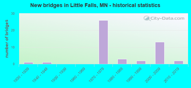
- New bridges - historical statistics
- 11930-1939
- 11940-1949
- 261970-1979
- 31980-1989
- 21990-1999
- 132000-2009
- 22010-2019

- Reconstructed bridges - Historical Statistics
- 11970-1979
- 01980-1989
- 01990-1999
- 52000-2009


- Bridge Condition - Deck
- 4.2%Very good
- 50.0%Good
- 41.7%Satisfactory
- 4.2%Fair

- Bridge Condition - Superstructure
- 4.2%Excellent
- 16.7%Very good
- 62.5%Good
- 12.5%Satisfactory
- 4.2%Fair

- Bridge Condition - Substructure
- 4.2%Excellent
- 8.3%Very good
- 41.7%Good
- 41.7%Satisfactory
- 4.2%Fair

- Bridge Condition - Channel
- 10.0%Excellent
- 10.0%Very good
- 35.0%Good
- 40.0%Satisfactory
- 5.0%Fair

- Bridge Condition - Culverts
- 20.0%Very good
- 50.0%Good
- 30.0%Satisfactory
Find on map >> Show street view
Structure Number: 49004, Location: 3.9 MI S OF JCT TH 371 (Lat: 45.944356, Lng: -94.356400), Route carried "on" structure: County highway 76, Year Built: 1973, Status: Open, Structure Length: 11.39m (37.37ft), Average Daily Traffic: 4,850 (year 2017), Truck Traffic: 3%, Average Future Daily Traffic: 4,850 (year 2039), Design Load: HS 20, Features Intersected: US 10
Minimum Vertical Clearance: 30+ m (98+ ft), Kilometerpoint: 0.000, Lanes on structure: 1, Lanes under structure: 4, Owner: State Highway Agency, Approaching Roadway Width: 8.2m (26.9ft), Skew: 4 degrees, Material/Design: Steel continuous, Design/Construction: Stringer/Multi-beam, Number Of Spans In Main Unit: 4, Length of Maximum Span: 34.4m (112.9ft), Curb-To-Curb Width: 7.9m (25.9ft), Out-to-Out Width: 9.1m (29.9ft)
Condition: Deck: Satisfactory, Superstructure: Satisfactory, Substructure: Satisfactory, Operating Rating: 59.8 metric tons, Method Used To Determine Operating Rating: Load Factor (LF), Inventory Rating: 35.9 metric tons, Method Used To Determine Inventory Rating: Load Factor (LF), Structural Evaluation: Equal to present minimum criteria, Deck Geometry: High priority of corrective action, Underclear: Equal to present minimum criteria, Approach Roadway Alignment: Better than present minimum criteria, Designated Inspection Frequency: Every 24 months, Inspection Date: October 2020, Deck Structure Type: Concrete Cast-file-Place, Wearing Surface/Protective System: Wearing Surface: Low Slump Concrete
Find on map >> Show street view
Structure Number: 49005, Location: AT THE JCT OF TH 27; 10 (Lat: 45.975553, Lng: -94.339683), Route carried "on" structure: US 10, Year Built: 1973, Status: Open, Structure Length: 3.22m (10.56ft), Average Daily Traffic: 10,000 (year 2017), Truck Traffic: 9%, Average Future Daily Traffic: 10,000 (year 2039), Design Load: HS 20, Features Intersected: MN 27
Minimum Vertical Clearance: 30+ m (98+ ft), Kilometerpoint: 0.000, Lanes on structure: 2, Lanes under structure: 4, Base Highway Network: Yes, Owner: State Highway Agency, Approaching Roadway Width: 11.3m (37.1ft), Material/Design: Steel, Design/Construction: Stringer/Multi-beam, Number Of Spans In Main Unit: 1, Length of Maximum Span: 30.5m (100.1ft), Curb-To-Curb Width: 12.3m (40.4ft), Out-to-Out Width: 13.4m (44.0ft)
Condition: Deck: Good, Superstructure: Good, Substructure: Good, Operating Rating: 72.7 metric tons, Method Used To Determine Operating Rating: Load Factor (LF), Inventory Rating: 43.6 metric tons, Method Used To Determine Inventory Rating: Load Factor (LF), Structural Evaluation: Better than present minimum criteria, Deck Geometry: Better than present minimum criteria, Underclear: Better than present minimum criteria, Approach Roadway Alignment: Better than present minimum criteria, Designated Inspection Frequency: Every 24 months, Inspection Date: October 2021, Deck Structure Type: Concrete Cast-file-Place, Wearing Surface/Protective System: Wearing Surface: Low Slump Concrete
Find on map >> Show street view
Structure Number: 49006, Location: AT THE JCT OF TH 27;10 (Lat: 45.975578, Lng: -94.340019), Route carried "on" structure: US 10, Year Built: 1973, Status: Open, Structure Length: 3.22m (10.56ft), Average Daily Traffic: 10,450 (year 2019), Truck Traffic: 8%, Average Future Daily Traffic: 10,000 (year 2039), Design Load: HS 20, Features Intersected: MN 27
Minimum Vertical Clearance: 30+ m (98+ ft), Kilometerpoint: 0.000, Lanes on structure: 2, Lanes under structure: 4, Base Highway Network: Yes, Owner: State Highway Agency, Approaching Roadway Width: 11.3m (37.1ft), Material/Design: Steel, Design/Construction: Stringer/Multi-beam, Number Of Spans In Main Unit: 1, Length of Maximum Span: 30.5m (100.1ft), Curb-To-Curb Width: 12.3m (40.4ft), Out-to-Out Width: 13.4m (44.0ft)
Condition: Deck: Good, Superstructure: Good, Substructure: Good, Operating Rating: 72.7 metric tons, Method Used To Determine Operating Rating: Load Factor (LF), Inventory Rating: 43.6 metric tons, Method Used To Determine Inventory Rating: Load Factor (LF), Structural Evaluation: Better than present minimum criteria, Deck Geometry: Better than present minimum criteria, Underclear: Better than present minimum criteria, Approach Roadway Alignment: Equal to present desirable criteria, Designated Inspection Frequency: Every 24 months, Inspection Date: October 2021, Deck Structure Type: Concrete Cast-file-Place, Wearing Surface/Protective System: Wearing Surface: Low Slump Concrete
Find on map >> Show street view
Structure Number: 49007, Location: 3.0 MI S OF LITTLE FALLS (Lat: 45.933753, Lng: -94.410103), Route carried "on" structure: State highway 238, Year Built: 2009, Status: Open, Structure Length: 3.18m (10.43ft), Average Daily Traffic: 1,500 (year 2019), Truck Traffic: 8%, Average Future Daily Traffic: 1,350 (year 2039), Design Load: HL 93, Features Intersected: SWAN RIVER
Minimum Vertical Clearance: 30+ m (98+ ft), Kilometerpoint: 0.000, Lanes on structure: 2, Owner: State Highway Agency, Approaching Roadway Width: 11.0m (36.1ft), Material/Design: Prestressed concrete, Design/Construction: Tee Beam, Number Of Spans In Main Unit: 3, Length of Maximum Span: 10.6m (34.8ft), Curb-To-Curb Width: 11.0m (36.1ft), Out-to-Out Width: 12.0m (39.4ft)
Condition: Deck: Satisfactory, Superstructure: Very good, Substructure: Very good, Channel: Very good, Operating Rating: 93.7 metric tons, Method Used To Determine Operating Rating: Load Factor (LF), Inventory Rating: 55.9 metric tons, Method Used To Determine Inventory Rating: Load Factor (LF), Structural Evaluation: Equal to present desirable criteria, Deck Geometry: Equal to present minimum criteria, Waterway Adequacy: Superior to present desirable criteria, Approach Roadway Alignment: Equal to present desirable criteria, Designated Inspection Frequency: Every 24 months, Inspection Date: September 2021, Deck Structure Type: Concrete Cast-file-Place, Wearing Surface/Protective System: Deck Protection: Epoxy Coated Reinforcing
Find on map >> Show street view
Structure Number: 49008, Location: AT JCT TH 371 (Lat: 45.994983, Lng: -94.341208), Route carried "on" structure: State highway 371, Year Built: 1972, Status: Open, Structure Length: 6.28m (20.60ft), Average Daily Traffic: 5,500 (year 2019), Truck Traffic: 8%, Average Future Daily Traffic: 5,000 (year 2039), Design Load: HS 20, Features Intersected: US 10 WB
Minimum Vertical Clearance: 30+ m (98+ ft), Kilometerpoint: 0.000, Lanes on structure: 2, Lanes under structure: 2, Base Highway Network: Yes, Owner: State Highway Agency, Approaching Roadway Width: 11.3m (37.1ft), Skew: 4 degrees, Material/Design: Prestressed concrete, Design/Construction: Stringer/Multi-beam, Number Of Spans In Main Unit: 3, Length of Maximum Span: 29.9m (98.1ft), Curb-To-Curb Width: 12.3m (40.4ft), Out-to-Out Width: 13.5m (44.3ft)
Condition: Deck: Good, Superstructure: Good, Substructure: Good, Operating Rating: 44.9 metric tons, Method Used To Determine Operating Rating: Load Factor (LF), Inventory Rating: 26.9 metric tons, Method Used To Determine Inventory Rating: Load Factor (LF), Structural Evaluation: Equal to present minimum criteria, Deck Geometry: Better than present minimum criteria, Underclear: Equal to present minimum criteria, Approach Roadway Alignment: Equal to present desirable criteria, Designated Inspection Frequency: Every 24 months, Inspection Date: October 2021, Deck Structure Type: Concrete Cast-file-Place, Wearing Surface/Protective System: Wearing Surface: Low Slump Concrete
Find on map >> Show street view
Structure Number: 49009, Location: 0.4 MI W OF JCT TH 371 (Lat: 45.998142, Lng: -94.348489), Route carried "on" structure: US 10, Year Built: 1974, Status: Open, Structure Length: 8.27m (27.13ft), Average Daily Traffic: 11,000 (year 2019), Truck Traffic: 11%, Average Future Daily Traffic: 10,100 (year 2039), Design Load: HS 20, Features Intersected: BNSF RR; CSAH 76
Minimum Vertical Clearance: 30+ m (98+ ft), Kilometerpoint: 0.000, Lanes on structure: 4, Lanes under structure: 2, Base Highway Network: Yes, Owner: State Highway Agency, Approaching Roadway Width: 25.3m (83.0ft), Skew: 31 degrees, Material/Design: Prestressed concrete, Design/Construction: Stringer/Multi-beam, Number Of Spans In Main Unit: 4, Length of Maximum Span: 27.1m (88.9ft), Curb-To-Curb Width: 24.9m (81.7ft), Out-to-Out Width: 27.0m (88.6ft)
Condition: Deck: Satisfactory, Superstructure: Good, Substructure: Satisfactory, Operating Rating: 69.6 metric tons, Method Used To Determine Operating Rating: Load Factor (LF), Inventory Rating: 35.9 metric tons, Method Used To Determine Inventory Rating: Load Factor (LF), Structural Evaluation: Equal to present minimum criteria, Deck Geometry: Superior to present desirable criteria, Underclear: Equal to present desirable criteria, Approach Roadway Alignment: Equal to present desirable criteria, Designated Inspection Frequency: Every 24 months, Inspection Date: October 2021, Deck Structure Type: Concrete Cast-file-Place, Wearing Surface/Protective System: Wearing Surface: Latex Concrete
Find on map >> Show street view
Structure Number: 4901, Location: 1.2 MI W OF JCT TH 371 (Lat: 45.999906, Lng: -94.366211), Route carried "on" structure: US 10, Year Built: 1973, Year Reconstructed: 2007, Status: Open, Structure Length: 30.40m (99.74ft), Average Daily Traffic: 11,000 (year 2019), Truck Traffic: 11%, Average Future Daily Traffic: 10,100 (year 2039), Design Load: HS 20, Features Intersected: MISSISSIPPI RIVER
Minimum Vertical Clearance: 30+ m (98+ ft), Kilometerpoint: 0.000, Lanes on structure: 4, Base Highway Network: Yes, Owner: State Highway Agency, Approaching Roadway Width: 26.0m (85.3ft), Skew: 31 degrees, Material/Design: Steel continuous, Design/Construction: Stringer/Multi-beam, Number Of Spans In Main Unit: 7, Length of Maximum Span: 47.0m (154.2ft), Curb-To-Curb Width: 25.5m (83.7ft), Out-to-Out Width: 27.2m (89.2ft)
Condition: Deck: Good, Superstructure: Good, Substructure: Good, Channel: Satisfactory, Operating Rating: 70.0 metric tons, Method Used To Determine Operating Rating: Load Factor (LF), Inventory Rating: 42.0 metric tons, Method Used To Determine Inventory Rating: Load Factor (LF), Structural Evaluation: Better than present minimum criteria, Deck Geometry: Superior to present desirable criteria, Waterway Adequacy: Equal to present desirable criteria, Approach Roadway Alignment: Equal to present desirable criteria, Length Of Structure Improvement: 9.27m (30.41ft), Designated Inspection Frequency: Every 24 months, Underwater Inspection Frequency: Every 60 months, Inspection Date: August 2020, Underwater Inspection Date: October 2020, Bridge Improvement Cost: $999,999,000, Total Project Cost: $1,000, Deck Structure Type: Concrete Cast-file-Place, Wearing Surface/Protective System: Wearing Surface: Low Slump Concrete, Deck Protection: Epoxy Coated Reinforcing
Find on map >> Show street view
Structure Number: 49011, Location: 2.2 MI W OF JCT TH 371 (Lat: 46.000814, Lng: -94.384964), Route carried "on" structure: US 10, Year Built: 1974, Year Reconstructed: 2007, Status: Open, Structure Length: 12.00m (39.37ft), Average Daily Traffic: 4,300 (year 2017), Truck Traffic: 10%, Average Future Daily Traffic: 4,300 (year 2039), Design Load: HS 20, Features Intersected: BNSF RR; CSAH 52
Minimum Vertical Clearance: 30+ m (98+ ft), Kilometerpoint: 0.000, Lanes on structure: 2, Lanes under structure: 2, Base Highway Network: Yes, Owner: State Highway Agency, Approaching Roadway Width: 11.3m (37.1ft), Skew: 4 degrees, Material/Design: Steel continuous, Design/Construction: Stringer/Multi-beam, Number Of Spans In Main Unit: 4, Length of Maximum Span: 35.8m (117.5ft), Curb-To-Curb Width: 12.3m (40.4ft), Out-to-Out Width: 13.5m (44.3ft)
Condition: Deck: Good, Superstructure: Good, Substructure: Good, Operating Rating: 78.0 metric tons, Method Used To Determine Operating Rating: Load Factor (LF), Inventory Rating: 46.9 metric tons, Method Used To Determine Inventory Rating: Load Factor (LF), Structural Evaluation: Better than present minimum criteria, Deck Geometry: Better than present minimum criteria, Underclear: Meets minimum limits, Approach Roadway Alignment: Equal to present desirable criteria, Designated Inspection Frequency: Every 24 months, Inspection Date: October 2020, Deck Structure Type: Concrete Cast-file-Place, Wearing Surface/Protective System: Wearing Surface: Low Slump Concrete
Find on map >> Show street view
Structure Number: 49012, Location: 2.2 MI W OF JCT TH 371 (Lat: 46.000575, Lng: -94.384750), Route carried "on" structure: US 10, Year Built: 1974, Year Reconstructed: 2007, Status: Open, Structure Length: 12.00m (39.37ft), Average Daily Traffic: 4,600 (year 2019), Truck Traffic: 12%, Average Future Daily Traffic: 4,300 (year 2039), Design Load: HS 20, Features Intersected: BNSF RR; CSAH 52
Minimum Vertical Clearance: 30+ m (98+ ft), Kilometerpoint: 0.000, Lanes on structure: 2, Lanes under structure: 2, Base Highway Network: Yes, Owner: State Highway Agency, Approaching Roadway Width: 11.3m (37.1ft), Skew: 4 degrees, Material/Design: Steel continuous, Design/Construction: Stringer/Multi-beam, Number Of Spans In Main Unit: 4, Length of Maximum Span: 35.8m (117.5ft), Curb-To-Curb Width: 12.3m (40.4ft), Out-to-Out Width: 13.5m (44.3ft)
Condition: Deck: Satisfactory, Superstructure: Good, Substructure: Satisfactory, Operating Rating: 78.0 metric tons, Method Used To Determine Operating Rating: Load Factor (LF), Inventory Rating: 46.9 metric tons, Method Used To Determine Inventory Rating: Load Factor (LF), Structural Evaluation: Equal to present minimum criteria, Deck Geometry: Better than present minimum criteria, Underclear: Meets minimum limits, Approach Roadway Alignment: Equal to present desirable criteria, Designated Inspection Frequency: Every 24 months, Inspection Date: October 2020, Deck Structure Type: Concrete Cast-file-Place, Wearing Surface/Protective System: Wearing Surface: Low Slump Concrete
Find on map >> Show street view
Structure Number: 49015, Location: 1.9 MI W OF JCT TH 371 (Lat: 46.000419, Lng: -94.378106), Route carried "on" structure: US 10, Year Built: 1974, Year Reconstructed: 2007, Status: Open, Structure Length: 5.41m (17.75ft), Average Daily Traffic: 4,300 (year 2017), Truck Traffic: 10%, Average Future Daily Traffic: 4,300 (year 2039), Design Load: HS 20, Features Intersected: CSAH 13
Minimum Vertical Clearance: 30+ m (98+ ft), Kilometerpoint: 0.000, Lanes on structure: 2, Lanes under structure: 2, Base Highway Network: Yes, Owner: State Highway Agency, Approaching Roadway Width: 11.3m (37.1ft), Material/Design: Prestressed concrete, Design/Construction: Stringer/Multi-beam, Number Of Spans In Main Unit: 3, Length of Maximum Span: 23.5m (77.1ft), Curb-To-Curb Width: 12.3m (40.4ft), Out-to-Out Width: 13.6m (44.6ft)
Condition: Deck: Good, Superstructure: Good, Substructure: Satisfactory, Operating Rating: 71.5 metric tons, Method Used To Determine Operating Rating: Load Factor (LF), Inventory Rating: 35.3 metric tons, Method Used To Determine Inventory Rating: Load Factor (LF), Structural Evaluation: Equal to present minimum criteria, Deck Geometry: Better than present minimum criteria, Underclear: Better than present minimum criteria, Approach Roadway Alignment: Equal to present desirable criteria, Designated Inspection Frequency: Every 24 months, Inspection Date: October 2020, Deck Structure Type: Concrete Cast-file-Place, Wearing Surface/Protective System: Wearing Surface: Low Slump Concrete
Find on map >> Show street view
Structure Number: 49016, Location: 1.9 MI W OF JCT TH 371 (Lat: 46.000203, Lng: -94.378119), Route carried "on" structure: US 10, Year Built: 1974, Year Reconstructed: 2007, Status: Open, Structure Length: 5.41m (17.75ft), Average Daily Traffic: 4,600 (year 2019), Truck Traffic: 12%, Average Future Daily Traffic: 4,300 (year 2039), Design Load: HS 20, Features Intersected: CSAH 13
Minimum Vertical Clearance: 30+ m (98+ ft), Kilometerpoint: 0.000, Lanes on structure: 2, Lanes under structure: 2, Base Highway Network: Yes, Owner: State Highway Agency, Approaching Roadway Width: 11.3m (37.1ft), Material/Design: Prestressed concrete, Design/Construction: Stringer/Multi-beam, Number Of Spans In Main Unit: 3, Length of Maximum Span: 23.5m (77.1ft), Curb-To-Curb Width: 12.3m (40.4ft), Out-to-Out Width: 13.6m (44.6ft)
Condition: Deck: Very good, Superstructure: Good, Substructure: Satisfactory, Operating Rating: 71.5 metric tons, Method Used To Determine Operating Rating: Load Factor (LF), Inventory Rating: 35.3 metric tons, Method Used To Determine Inventory Rating: Load Factor (LF), Structural Evaluation: Equal to present minimum criteria, Deck Geometry: Better than present minimum criteria, Underclear: Better than present minimum criteria, Approach Roadway Alignment: Equal to present desirable criteria, Designated Inspection Frequency: Every 24 months, Inspection Date: October 2020, Deck Structure Type: Concrete Cast-file-Place, Wearing Surface/Protective System: Wearing Surface: Low Slump Concrete
Find on map >> Show street view
Structure Number: 49019, Location: 2.2 MI S OF JCT TH 371 (Lat: 45.963408, Lng: -94.355606), Route carried "on" structure: County highway 257, Year Built: 1972, Status: Open, Structure Length: 8.69m (28.51ft), Average Daily Traffic: 390 (year 2017), Average Future Daily Traffic: 390 (year 2039), Design Load: HS 20, Features Intersected: US 10
Minimum Vertical Clearance: 30+ m (98+ ft), Kilometerpoint: 0.000, Lanes on structure: 2, Lanes under structure: 4, Owner: State Highway Agency, Approaching Roadway Width: 12.5m (41.0ft), Material/Design: Prestressed concrete, Design/Construction: Stringer/Multi-beam, Number Of Spans In Main Unit: 4, Length of Maximum Span: 26.1m (85.6ft), Curb or Sidewalk Widths: Left: 1.8m (5.9ft), Right: 1.8m (5.9ft), Curb-To-Curb Width: 11.0m (36.1ft), Out-to-Out Width: 15.3m (50.2ft)
Condition: Deck: Satisfactory, Superstructure: Good, Substructure: Satisfactory, Operating Rating: 63.7 metric tons, Method Used To Determine Operating Rating: Load Factor (LF), Inventory Rating: 25.7 metric tons, Method Used To Determine Inventory Rating: Load Factor (LF), Structural Evaluation: Equal to present minimum criteria, Deck Geometry: Equal to present desirable criteria, Underclear: Better than present minimum criteria, Approach Roadway Alignment: Better than present minimum criteria, Designated Inspection Frequency: Every 24 months, Inspection Date: October 2021, Deck Structure Type: Concrete Cast-file-Place, Wearing Surface/Protective System: Wearing Surface: Monolithic Concrete
Find on map >> Show street view
Structure Number: 49036, Location: 0.3 MI S OF LITTLE FALLS (Lat: 45.972039, Lng: -94.409294), Route carried "on" structure: State highway 238, Year Built: 2009, Status: Open, Structure Length: 2.20m (7.22ft), Average Daily Traffic: 1,900 (year 2019), Truck Traffic: 8%, Average Future Daily Traffic: 2,050 (year 2039), Design Load: HL 93, Features Intersected: PIKE CREEK
Minimum Vertical Clearance: 30+ m (98+ ft), Kilometerpoint: 0.000, Lanes on structure: 2, Owner: State Highway Agency, Approaching Roadway Width: 11.0m (36.1ft), Material/Design: Prestressed concrete, Design/Construction: Tee Beam, Number Of Spans In Main Unit: 3, Length of Maximum Span: 7.4m (24.3ft), Curb-To-Curb Width: 12.2m (40.0ft), Out-to-Out Width: 13.2m (43.3ft)
Condition: Deck: Satisfactory, Superstructure: Excellent, Substructure: Good, Channel: Excellent, Operating Rating: 99.6 metric tons, Method Used To Determine Operating Rating: Load Factor (LF), Inventory Rating: 70.7 metric tons, Method Used To Determine Inventory Rating: Load Factor (LF), Structural Evaluation: Better than present minimum criteria, Deck Geometry: Better than present minimum criteria, Waterway Adequacy: Better than present minimum criteria, Approach Roadway Alignment: Equal to present desirable criteria, Designated Inspection Frequency: Every 24 months, Inspection Date: September 2021, Deck Structure Type: Concrete Cast-file-Place, Wearing Surface/Protective System: Deck Protection: Epoxy Coated Reinforcing
Find on map >> Show street view
Structure Number: 49037, Location: 2.8 MI N OF JCT TH 10 (Lat: 46.026603, Lng: -94.335633), Route carried "on" structure: State highway 371, Year Built: 2005, Status: Open, Structure Length: 6.06m (19.88ft), Average Daily Traffic: 5,000 (year 2017), Truck Traffic: 8%, Average Future Daily Traffic: 5,000 (year 2039), Design Load: HL 93, Features Intersected: CSAH 46
Minimum Vertical Clearance: 30+ m (98+ ft), Kilometerpoint: 0.000, Lanes on structure: 2, Lanes under structure: 2, Base Highway Network: Yes, Owner: State Highway Agency, Approaching Roadway Width: 12.8m (42.0ft), Skew: 1 degrees, Material/Design: Prestressed concrete, Design/Construction: Stringer/Multi-beam, Number Of Spans In Main Unit: 3, Length of Maximum Span: 26.7m (87.6ft), Curb-To-Curb Width: 12.8m (42.0ft), Out-to-Out Width: 13.8m (45.3ft)
Condition: Deck: Good, Superstructure: Good, Substructure: Good, Operating Rating: 62.7 metric tons, Method Used To Determine Operating Rating: Load Factor (LF), Inventory Rating: 34.3 metric tons, Method Used To Determine Inventory Rating: Load Factor (LF), Structural Evaluation: Better than present minimum criteria, Deck Geometry: Equal to present desirable criteria, Underclear: Equal to present minimum criteria, Approach Roadway Alignment: Equal to present desirable criteria, Length Of Structure Improvement: 2.04m (6.69ft), Designated Inspection Frequency: Every 24 months, Inspection Date: October 2020, Bridge Improvement Cost: $981,000,000, Roadway Improvement Cost: $1,000, Total Project Cost: $1,000, Deck Structure Type: Concrete Cast-file-Place, Wearing Surface/Protective System: Wearing Surface: Monolithic Concrete, Deck Protection: Epoxy Coated Reinforcing
Find on map >> Show street view
Structure Number: 49038, Location: 2.8 MI N OF JCT TH 10 (Lat: 46.026578, Lng: -94.335214), Route carried "on" structure: State highway 371, Year Built: 2005, Status: Open, Structure Length: 6.06m (19.88ft), Average Daily Traffic: 5,500 (year 2019), Truck Traffic: 9%, Average Future Daily Traffic: 5,000 (year 2039), Design Load: HL 93, Features Intersected: CSAH 46
Minimum Vertical Clearance: 30+ m (98+ ft), Kilometerpoint: 0.000, Lanes on structure: 2, Lanes under structure: 2, Base Highway Network: Yes, Owner: State Highway Agency, Approaching Roadway Width: 12.8m (42.0ft), Skew: 1 degrees, Material/Design: Prestressed concrete, Design/Construction: Stringer/Multi-beam, Number Of Spans In Main Unit: 3, Length of Maximum Span: 26.7m (87.6ft), Curb-To-Curb Width: 12.8m (42.0ft), Out-to-Out Width: 13.8m (45.3ft)
Condition: Deck: Good, Superstructure: Very good, Substructure: Good, Operating Rating: 62.7 metric tons, Method Used To Determine Operating Rating: Load Factor (LF), Inventory Rating: 34.3 metric tons, Method Used To Determine Inventory Rating: Load Factor (LF), Structural Evaluation: Better than present minimum criteria, Deck Geometry: Equal to present desirable criteria, Underclear: Equal to present minimum criteria, Approach Roadway Alignment: Equal to present desirable criteria, Length Of Structure Improvement: 2.04m (6.69ft), Designated Inspection Frequency: Every 24 months, Inspection Date: October 2020, Bridge Improvement Cost: $981,000,000, Roadway Improvement Cost: $1,000, Total Project Cost: $1,000, Deck Structure Type: Concrete Cast-file-Place, Wearing Surface/Protective System: Wearing Surface: Monolithic Concrete, Deck Protection: Epoxy Coated Reinforcing
Find on map >> Show street view
Structure Number: 49039, Location: AT THE JCT TH 371; 115 (Lat: 46.071700, Lng: -94.325211), Route carried "on" structure: State highway 371, Year Built: 2005, Status: Open, Structure Length: 6.16m (20.21ft), Average Daily Traffic: 6,150 (year 2017), Truck Traffic: 8%, Average Future Daily Traffic: 6,150 (year 2039), Design Load: HL 93, Features Intersected: TH 115
Minimum Vertical Clearance: 30+ m (98+ ft), Kilometerpoint: 0.000, Lanes on structure: 2, Lanes under structure: 2, Base Highway Network: Yes, Owner: State Highway Agency, Approaching Roadway Width: 11.6m (38.1ft), Skew: 1 degrees, Material/Design: Prestressed concrete, Design/Construction: Stringer/Multi-beam, Number Of Spans In Main Unit: 3, Length of Maximum Span: 27.5m (90.2ft), Curb-To-Curb Width: 12.8m (42.0ft), Out-to-Out Width: 13.8m (45.3ft)
Condition: Deck: Good, Superstructure: Good, Substructure: Good, Operating Rating: 64.3 metric tons, Method Used To Determine Operating Rating: Load Factor (LF), Inventory Rating: 34.6 metric tons, Method Used To Determine Inventory Rating: Load Factor (LF), Structural Evaluation: Better than present minimum criteria, Deck Geometry: Equal to present desirable criteria, Underclear: Superior to present desirable criteria, Approach Roadway Alignment: Equal to present desirable criteria, Length Of Structure Improvement: 2.07m (6.79ft), Designated Inspection Frequency: Every 24 months, Inspection Date: October 2020, Bridge Improvement Cost: $997,000,000, Roadway Improvement Cost: $1,000, Total Project Cost: $1,000, Deck Structure Type: Concrete Cast-file-Place, Wearing Surface/Protective System: Wearing Surface: Monolithic Concrete, Deck Protection: Epoxy Coated Reinforcing
Find on map >> Show street view
Structure Number: 4904, Location: AT THE JCT TH 371; 115 (Lat: 46.071628, Lng: -94.324775), Route carried "on" structure: State highway 371, Year Built: 2005, Status: Open, Structure Length: 6.16m (20.21ft), Average Daily Traffic: 6,450 (year 2019), Truck Traffic: 8%, Average Future Daily Traffic: 6,150 (year 2039), Design Load: HL 93, Features Intersected: TH 115
Minimum Vertical Clearance: 30+ m (98+ ft), Kilometerpoint: 0.000, Lanes on structure: 2, Lanes under structure: 2, Base Highway Network: Yes, Owner: State Highway Agency, Approaching Roadway Width: 12.8m (42.0ft), Skew: 1 degrees, Material/Design: Prestressed concrete, Design/Construction: Stringer/Multi-beam, Number Of Spans In Main Unit: 3, Length of Maximum Span: 27.5m (90.2ft), Curb-To-Curb Width: 12.8m (42.0ft), Out-to-Out Width: 13.8m (45.3ft)
Condition: Deck: Good, Superstructure: Very good, Substructure: Good, Operating Rating: 64.3 metric tons, Method Used To Determine Operating Rating: Load Factor (LF), Inventory Rating: 34.6 metric tons, Method Used To Determine Inventory Rating: Load Factor (LF), Structural Evaluation: Better than present minimum criteria, Deck Geometry: Equal to present desirable criteria, Underclear: Superior to present desirable criteria, Approach Roadway Alignment: Equal to present desirable criteria, Length Of Structure Improvement: 2.07m (6.79ft), Designated Inspection Frequency: Every 24 months, Inspection Date: October 2020, Bridge Improvement Cost: $997,000,000, Roadway Improvement Cost: $1,000, Total Project Cost: $1,000, Deck Structure Type: Concrete Cast-file-Place, Wearing Surface/Protective System: Wearing Surface: Monolithic Concrete, Deck Protection: Epoxy Coated Reinforcing
Find on map >> Show street view
Structure Number: 49042, Location: 0.8 MI W OF JCT TH 371 (Lat: 45.999928, Lng: -94.370000), Route carried "on" structure: US 10, Year Built: 2010, Status: Open, Structure Length: 4.07m (13.35ft), Average Daily Traffic: 11,000 (year 2019), Truck Traffic: 11%, Average Future Daily Traffic: 10,100 (year 2039), Design Load: HL 93, Features Intersected: MISS. RIVER BACK CHANNEL
Minimum Vertical Clearance: 30+ m (98+ ft), Kilometerpoint: 0.000, Lanes on structure: 4, Base Highway Network: Yes, Owner: State Highway Agency, Approaching Roadway Width: 25.9m (85.0ft), Skew: 33 degrees, Material/Design: Prestressed concrete, Design/Construction: Stringer/Multi-beam, Number Of Spans In Main Unit: 1, Length of Maximum Span: 39.6m (129.9ft), Curb-To-Curb Width: 25.5m (83.7ft), Out-to-Out Width: 27.2m (89.2ft)
Condition: Deck: Good, Superstructure: Very good, Substructure: Excellent, Channel: Excellent, Operating Rating: 80.2 metric tons, Method Used To Determine Operating Rating: Load Factor (LF), Inventory Rating: 37.1 metric tons, Method Used To Determine Inventory Rating: Load Factor (LF), Structural Evaluation: Equal to present desirable criteria, Deck Geometry: Superior to present desirable criteria, Waterway Adequacy: Superior to present desirable criteria, Approach Roadway Alignment: Better than present minimum criteria, Designated Inspection Frequency: Every 24 months, Inspection Date: October 2021, Deck Structure Type: Concrete Cast-file-Place, Wearing Surface/Protective System: Deck Protection: Epoxy Coated Reinforcing
Find on map >> Show street view
Structure Number: 49521, Location: 0.9 MI N OF JCT CSAH 12 (Lat: 45.952786, Lng: -94.391031), Route carried "on" structure: County highway 52, Year Built: 1978, Status: Open, Structure Length: 3.84m (12.60ft), Average Daily Traffic: 640 (year 2017), Truck Traffic: 8%, Average Future Daily Traffic: 640 (year 2037), Design Load: HS 20, Features Intersected: PIKE CREEK
Minimum Vertical Clearance: 30+ m (98+ ft), Kilometerpoint: 0.000, Lanes on structure: 2, Owner: County Highway Agency, Approaching Roadway Width: 11.0m (36.1ft), Skew: 3 degrees, Material/Design: Wood or Timber, Design/Construction: Stringer/Multi-beam, Number Of Spans In Main Unit: 3, Length of Maximum Span: 12.8m (42.0ft), Curb or Sidewalk Widths: Left: 0.0m, Right: 3.0m (9.8ft), Curb-To-Curb Width: 11.3m (37.1ft), Out-to-Out Width: 14.4m (47.2ft)
Condition: Deck: Satisfactory, Superstructure: Good, Substructure: Satisfactory, Channel: Satisfactory, Operating Rating: 39.2 metric tons, Method Used To Determine Operating Rating: Allowable Stress (AS), Inventory Rating: 24.5 metric tons, Method Used To Determine Inventory Rating: Allowable Stress (AS), Structural Evaluation: Equal to present minimum criteria, Deck Geometry: Better than present minimum criteria, Waterway Adequacy: Superior to present desirable criteria, Approach Roadway Alignment: Better than present minimum criteria, Designated Inspection Frequency: Every 24 months, Underwater Inspection Frequency: Every 60 months, Inspection Date: October 2021, Underwater Inspection Date: November 2020, Deck Structure Type: Wood or Timber, Wearing Surface/Protective System: Wearing Surface: Bituminous
Find on map >> Show street view
Structure Number: 49523, Location: 5.7 MI S OF JCT CR 223 (Lat: 45.918664, Lng: -94.389161), Route carried "on" structure: County highway 52, Year Built: 1978, Status: Posted for load, Structure Length: 2.74m (8.99ft), Average Daily Traffic: 640 (year 2017), Truck Traffic: 4%, Average Future Daily Traffic: 640 (year 2037), Design Load: HS 20, Features Intersected: SWAN RIVER
Minimum Vertical Clearance: 30+ m (98+ ft), Kilometerpoint: 0.000, Lanes on structure: 2, Owner: County Highway Agency, Approaching Roadway Width: 9.8m (32.2ft), Material/Design: Wood or Timber, Design/Construction: Slab, Number Of Spans In Main Unit: 3, Length of Maximum Span: 9.1m (29.9ft), Curb-To-Curb Width: 9.8m (32.2ft), Out-to-Out Width: 10.4m (34.1ft)
Condition: Deck: Fair, Superstructure: Fair, Substructure: Satisfactory, Channel: Satisfactory, Operating Rating: 45.4 metric tons, Method Used To Determine Operating Rating: Allowable Stress (AS), Inventory Rating: 30.7 metric tons, Method Used To Determine Inventory Rating: Allowable Stress (AS), Structural Evaluation: Somewhat better than minimum adequacy, Deck Geometry: Equal to present minimum criteria, Waterway Adequacy: Better than present minimum criteria, Approach Roadway Alignment: Equal to present desirable criteria, Bridge Posting: Required (Relationship of Operating Rating to Maximum Legal Load: 10.0 - 19.9% below), Length Of Structure Improvement: 3.05m (10.01ft), Designated Inspection Frequency: Every 24 months, Inspection Date: October 2021, Bridge Improvement Cost: $800,000,000, Roadway Improvement Cost: $200,000,000, Total Project Cost: $999,999,000 ( Estimate for 2019), Deck Structure Type: Wood or Timber, Wearing Surface/Protective System: Wearing Surface: Bituminous
Find on map >> Show street view
Structure Number: 49529, Location: 0.6 MI E OF JCT CSAH 13 (Lat: 46.011653, Lng: -94.365386), Route carried "on" structure: County highway 213, Year Built: 1985, Status: Open, Structure Length: 2.96m (9.71ft), Average Daily Traffic: 870 (year 2017), Truck Traffic: 8%, Average Future Daily Traffic: 870 (year 2037), Design Load: HS 20, Features Intersected: LITTLE ELK RIVER
Minimum Vertical Clearance: 30+ m (98+ ft), Kilometerpoint: 0.000, Lanes on structure: 2, Owner: County Highway Agency, Approaching Roadway Width: 11.0m (36.1ft), Skew: 1 degrees, Material/Design: Prestressed concrete, Design/Construction: Stringer/Multi-beam, Number Of Spans In Main Unit: 1, Length of Maximum Span: 29.0m (95.1ft), Curb or Sidewalk Widths: Left: 0.0m, Right: 1.8m (5.9ft), Curb-To-Curb Width: 11.0m (36.1ft), Out-to-Out Width: 13.7m (44.9ft)
Condition: Deck: Satisfactory, Superstructure: Good, Substructure: Satisfactory, Channel: Fair, Operating Rating: 41.5 metric tons, Method Used To Determine Operating Rating: Load Factor (LF), Inventory Rating: 24.9 metric tons, Method Used To Determine Inventory Rating: Load Factor (LF), Structural Evaluation: Equal to present minimum criteria, Deck Geometry: Better than present minimum criteria, Waterway Adequacy: Better than present minimum criteria, Approach Roadway Alignment: Equal to present desirable criteria, Designated Inspection Frequency: Every 24 months, Inspection Date: October 2021, Deck Structure Type: Concrete Cast-file-Place, Wearing Surface/Protective System: Wearing Surface: Monolithic Concrete
Find on map >> Show street view
Structure Number: 49543, Location: 1.5 MI N OF JCT TH 10 (Lat: 46.020203, Lng: -94.377761), Route carried "on" structure: County highway 13, Year Built: 1995, Status: Open, Structure Length: 2.87m (9.42ft), Average Daily Traffic: 1,000 (year 2017), Truck Traffic: 3%, Average Future Daily Traffic: 1,000 (year 2037), Design Load: HS 25 or greater, Features Intersected: LITTLE ELK RIVER
Minimum Vertical Clearance: 30+ m (98+ ft), Kilometerpoint: 0.000, Lanes on structure: 2, Owner: County Highway Agency, Approaching Roadway Width: 11.0m (36.1ft), Skew: 3 degrees, Material/Design: Prestressed concrete, Design/Construction: Stringer/Multi-beam, Number Of Spans In Main Unit: 1, Length of Maximum Span: 28.6m (93.8ft), Curb-To-Curb Width: 12.2m (40.0ft), Out-to-Out Width: 13.2m (43.3ft)
Condition: Deck: Good, Superstructure: Good, Substructure: Very good, Channel: Good, Operating Rating: 59.0 metric tons, Method Used To Determine Operating Rating: Load and Resistance Factor Rating (LRFR) rating reported by rating factor(RF) method using HL-93 loadings, Inventory Rating: 45.4 metric tons, Method Used To Determine Inventory Rating: Load and Resistance Factor Rating (LRFR) rating reported by rating factor(RF) method using HL-93 loadings, Structural Evaluation: Better than present minimum criteria, Deck Geometry: Equal to present desirable criteria, Waterway Adequacy: Superior to present desirable criteria, Approach Roadway Alignment: Equal to present desirable criteria, Designated Inspection Frequency: Every 24 months, Inspection Date: November 2021, Deck Structure Type: Concrete Cast-file-Place, Wearing Surface/Protective System: Wearing Surface: Monolithic Concrete, Deck Protection: Epoxy Coated Reinforcing
Find on map >> Show street view
Structure Number: 4969, Location: AT CAMP RIPLEY (Lat: 46.074378, Lng: -94.334831), Route carried "on" structure: State highway 115, Year Built: 1930, Status: Open, Structure Length: 12.56m (41.21ft), Average Daily Traffic: 3,150 (year 2019), Truck Traffic: 8%, Average Future Daily Traffic: 2,900 (year 2039), Design Load: Railroad, Features Intersected: MISSISSIPPI RIVER
Minimum Vertical Clearance: 30+ m (98+ ft), Kilometerpoint: 0.000, Lanes on structure: 2, Owner: State Highway Agency, Approaching Roadway Width: 9.1m (29.9ft), Material/Design: Steel, Design/Construction: Stringer/Multi-beam, Number Of Spans In Main Unit: 5, Length of Maximum Span: 25.0m (82.0ft), Curb-To-Curb Width: 8.6m (28.2ft), Out-to-Out Width: 9.6m (31.5ft)
Condition: Deck: Satisfactory, Superstructure: Satisfactory, Substructure: Satisfactory, Channel: Good, Operating Rating: 91.2 metric tons, Method Used To Determine Operating Rating: Load Factor (LF), Inventory Rating: 54.7 metric tons, Method Used To Determine Inventory Rating: Load Factor (LF), Structural Evaluation: Equal to present minimum criteria, Deck Geometry: Meets minimum limits, Waterway Adequacy: Superior to present desirable criteria, Approach Roadway Alignment: Equal to present desirable criteria, Length Of Structure Improvement: 3.84m (12.60ft), Designated Inspection Frequency: Every 24 months, Underwater Inspection Frequency: Every 60 months, Inspection Date: August 2020, Underwater Inspection Date: August 2021, Bridge Improvement Cost: $999,999,000, Roadway Improvement Cost: $100,000,000, Total Project Cost: $999,999,000, Deck Structure Type: Concrete Cast-file-Place, Wearing Surface/Protective System: Wearing Surface: Monolithic Concrete, Deck Protection: Epoxy Coated Reinforcing
Find on map >> Show street view
Structure Number: 49J04, Location: 0.4 MI E OF JCT TH 10 (Lat: 46.034736, Lng: -94.423844), Route carried "on" structure: County highway 250, Year Built: 1999, Status: Open, Structure Length: 2.20m (7.22ft), Average Daily Traffic: 40 (year 1997), Average Future Daily Traffic: 40 (year 2029), Design Load: HS 25 or greater, Features Intersected: LITTLE ELK RIVER
Minimum Vertical Clearance: 30+ m (98+ ft), Kilometerpoint: 0.000, Lanes on structure: 2, Owner: Town or Township Highway Agency, Approaching Roadway Width: 8.5m (27.9ft), Skew: 3 degrees, Material/Design: Concrete, Design/Construction: Culvert, Number Of Spans In Main Unit: 3, Length of Maximum Span: 6.4m (21.0ft)
Condition: Channel: Good, Culverts: Good, Operating Rating: 68.6 metric tons, Method Used To Determine Operating Rating: Assigned ratings based on Allowable Stress Design (ASD) reported in metric tons, Inventory Rating: 40.8 metric tons, Method Used To Determine Inventory Rating: Assigned ratings based on Allowable Stress Design (ASD) reported in metric tons, Structural Evaluation: Better than present minimum criteria, Waterway Adequacy: Equal to present minimum criteria, Approach Roadway Alignment: Better than present minimum criteria, Designated Inspection Frequency: Every 24 months, Inspection Date: November 2021
Find on map >> Show street view
Structure Number: 49J08, Location: 0.5 MI S OF JCT TH 28 (Lat: 45.970131, Lng: -94.430503), Route carried "on" structure: County highway 139, Year Built: 2002, Status: Open, Structure Length: 1.07m (3.51ft), Average Daily Traffic: 40 (year 2000), Average Future Daily Traffic: 40 (year 2029), Design Load: HS 25 or greater, Features Intersected: PIKE CREEK
Minimum Vertical Clearance: 30+ m (98+ ft), Kilometerpoint: 0.000, Lanes on structure: 2, Owner: Town or Township Highway Agency, Approaching Roadway Width: 8.5m (27.9ft), Material/Design: Concrete, Design/Construction: Culvert, Number Of Spans In Main Unit: 3, Length of Maximum Span: 3.0m (9.8ft)
Condition: Channel: Satisfactory, Culverts: Good, Operating Rating: 68.6 metric tons, Method Used To Determine Operating Rating: Assigned rating based on Load Factor Design (LFD) reported in metric tons, Inventory Rating: 40.8 metric tons, Method Used To Determine Inventory Rating: Assigned rating based on Load Factor Design (LFD) reported in metric tons, Structural Evaluation: Better than present minimum criteria, Waterway Adequacy: Equal to present minimum criteria, Approach Roadway Alignment: Equal to present desirable criteria, Length Of Structure Improvement: 0.46m (1.51ft), Designated Inspection Frequency: Every 48 months, Inspection Date: October 2019, Bridge Improvement Cost: $69,000,000
Find on map >> Show street view
Structure Number: 49J61, Location: 0.6 MI NE OF JCT TH 238 (Lat: 45.967858, Lng: -94.399217), Route carried "on" structure: County highway 17, Year Built: 2010, Status: Open, Structure Length: 1.39m (4.56ft), Average Daily Traffic: 225 (year 2017), Truck Traffic: 8%, Average Future Daily Traffic: 225 (year 2037), Design Load: HS 25 or greater, Features Intersected: PIKE CREEK
Minimum Vertical Clearance: 30+ m (98+ ft), Kilometerpoint: 0.000, Lanes on structure: 2, Owner: County Highway Agency, Approaching Roadway Width: 10.4m (34.1ft), Material/Design: Concrete, Design/Construction: Culvert, Number Of Spans In Main Unit: 3, Length of Maximum Span: 4.3m (14.1ft)
Condition: Channel: Good, Culverts: Very good, Operating Rating: 58.8 metric tons, Method Used To Determine Operating Rating: Assigned rating based on Load Factor Design (LFD) reported in metric tons, Inventory Rating: 39.2 metric tons, Method Used To Determine Inventory Rating: Assigned rating based on Load Factor Design (LFD) reported in metric tons, Structural Evaluation: Equal to present desirable criteria, Waterway Adequacy: Equal to present desirable criteria, Approach Roadway Alignment: Equal to present desirable criteria, Designated Inspection Frequency: Every 48 months, Inspection Date: October 2019
Find on map >> Show street view
Structure Number: 49X04, Location: 0.5 MI S OF JCT TH 115 (Lat: 46.063342, Lng: -94.324919), Route carried "on" structure: State highway 371, Year Built: 2005, Status: Open, Structure Length: 1.13m (3.71ft), Average Daily Traffic: 12,900 (year 2019), Truck Traffic: 8%, Average Future Daily Traffic: 12,300 (year 2039), Design Load: HS 25 or greater, Features Intersected: FLETCHER CREEK
Minimum Vertical Clearance: 30+ m (98+ ft), Kilometerpoint: 0.000, Lanes on structure: 4, Base Highway Network: Yes, Owner: State Highway Agency, Approaching Roadway Width: 23.2m (76.1ft), Skew: 1 degrees, Material/Design: Concrete, Design/Construction: Culvert, Number Of Spans In Main Unit: 2, Length of Maximum Span: 5.1m (16.7ft)
Condition: Channel: Satisfactory, Culverts: Satisfactory, Operating Rating: 58.8 metric tons, Method Used To Determine Operating Rating: Assigned rating based on Load Factor Design (LFD) reported in metric tons, Inventory Rating: 39.2 metric tons, Method Used To Determine Inventory Rating: Assigned rating based on Load Factor Design (LFD) reported in metric tons, Structural Evaluation: Equal to present minimum criteria, Waterway Adequacy: Superior to present desirable criteria, Approach Roadway Alignment: Equal to present desirable criteria, Length Of Structure Improvement: 0.49m (1.61ft), Designated Inspection Frequency: Every 48 months, Inspection Date: October 2019, Bridge Improvement Cost: $343,000,000, Roadway Improvement Cost: $1,000, Total Project Cost: $1,000
Find on map >> Show street view
Structure Number: 49X05, Location: 0.5 MI S OF JCT TH 115 (Lat: 46.062958, Lng: -94.327933), Route carried "on" structure: County highway 76, Year Built: 2004, Status: Open, Structure Length: 1.06m (3.48ft), Average Daily Traffic: 3,150 (year 2017), Truck Traffic: 5%, Average Future Daily Traffic: 3,150 (year 2037), Design Load: HS 25 or greater, Features Intersected: FLETCHER CRK (CD # 14)
Minimum Vertical Clearance: 30+ m (98+ ft), Kilometerpoint: 0.000, Lanes on structure: 2, Owner: County Highway Agency, Approaching Roadway Width: 13.4m (44.0ft), Material/Design: Concrete, Design/Construction: Culvert, Number Of Spans In Main Unit: 2, Length of Maximum Span: 4.9m (16.1ft)
Condition: Channel: Satisfactory, Culverts: Very good, Operating Rating: 58.8 metric tons, Method Used To Determine Operating Rating: Assigned rating based on Load Factor Design (LFD) reported in metric tons, Inventory Rating: 39.2 metric tons, Method Used To Determine Inventory Rating: Assigned rating based on Load Factor Design (LFD) reported in metric tons, Structural Evaluation: Equal to present desirable criteria, Waterway Adequacy: Superior to present desirable criteria, Approach Roadway Alignment: Equal to present desirable criteria, Designated Inspection Frequency: Every 48 months, Inspection Date: November 2020
Find on map >> Show street view
Structure Number: 5907, Location: IN LITTLE FALLS (Lat: 45.977131, Lng: -94.368356), Route carried "on" structure: State highway 27, Year Built: 1941, Year Reconstructed: 1983, Status: Open, Structure Length: 16.63m (54.56ft), Average Daily Traffic: 14,200 (year 2019), Truck Traffic: 5%, Average Future Daily Traffic: 13,800 (year 2039), Design Load: H 15, Features Intersected: MISSISSIPPI RIVER
Minimum Vertical Clearance: 30+ m (98+ ft), Kilometerpoint: 0.000, Lanes on structure: 4, Owner: State Highway Agency, Approaching Roadway Width: 19.5m (64.0ft), Material/Design: Steel continuous, Design/Construction: Stringer/Multi-beam, Number Of Spans In Main Unit: 5, Number Of Approach Spans: 2, Length of Maximum Span: 30.6m (100.4ft), Curb or Sidewalk Widths: Left: 2.4m (7.9ft), Right: 2.4m (7.9ft), Curb-To-Curb Width: 15.9m (52.2ft), Out-to-Out Width: 21.4m (70.2ft)
Condition: Deck: Satisfactory, Superstructure: Satisfactory, Substructure: Fair, Channel: Satisfactory, Operating Rating: 32.7 metric tons, Method Used To Determine Operating Rating: Allowable Stress (AS), Inventory Rating: 24.5 metric tons, Method Used To Determine Inventory Rating: Allowable Stress (AS), Structural Evaluation: Somewhat better than minimum adequacy, Deck Geometry: Meets minimum limits, Waterway Adequacy: Equal to present desirable criteria, Approach Roadway Alignment: Equal to present desirable criteria, Designated Inspection Frequency: Every 24 months, Underwater Inspection Frequency: Every 60 months, Inspection Date: September 2020, Underwater Inspection Date: September 2021, Deck Structure Type: Concrete Cast-file-Place, Wearing Surface/Protective System: Wearing Surface: Low Slump Concrete
Find on map >> Show street view
Structure Number: 93095, Location: 0.4 MI E OF JCT CR 210 (Lat: 46.042028, Lng: -94.421792), Route carried "on" structure: County highway 211, Year Built: 1974, Status: Open, Structure Length: 1.78m (5.84ft), Average Daily Traffic: 140 (year 2017), Average Future Daily Traffic: 140 (year 2037), Design Load: HS 20, Features Intersected: LITTLE ELK RIVER
Minimum Vertical Clearance: 30+ m (98+ ft), Kilometerpoint: 0.000, Lanes on structure: 2, Owner: County Highway Agency, Approaching Roadway Width: 9.8m (32.2ft), Material/Design: Concrete, Design/Construction: Culvert, Number Of Spans In Main Unit: 3, Length of Maximum Span: 4.8m (15.7ft)
Condition: Channel: Good, Culverts: Satisfactory, Operating Rating: 53.9 metric tons, Method Used To Determine Operating Rating: Assigned ratings based on Allowable Stress Design (ASD) reported in metric tons, Inventory Rating: 35.9 metric tons, Method Used To Determine Inventory Rating: Assigned ratings based on Allowable Stress Design (ASD) reported in metric tons, Structural Evaluation: Equal to present minimum criteria, Waterway Adequacy: Equal to present desirable criteria, Approach Roadway Alignment: Equal to present desirable criteria, Designated Inspection Frequency: Every 48 months, Inspection Date: October 2020
Find on map >> Show street view
Structure Number: 93728, Location: 0.8 MI N OF JCT TH 27 (Lat: 45.987392, Lng: -94.365914), Route carried "on" structure: County highway 201, Year Built: 1977, Status: Open, Structure Length: 0.68m (2.23ft), Average Daily Traffic: 900 (year 2017), Truck Traffic: 5%, Average Future Daily Traffic: 900 (year 2037), Design Load: HS 20, Features Intersected: DITCH
Minimum Vertical Clearance: 30+ m (98+ ft), Kilometerpoint: 0.000, Lanes on structure: 2, Owner: County Highway Agency, Approaching Roadway Width: 11.0m (36.1ft), Skew: 3 degrees, Material/Design: Concrete, Design/Construction: Culvert, Number Of Spans In Main Unit: 1, Number Of Approach Spans: 1, Length of Maximum Span: 3.2m (10.5ft)
Condition: Channel: Satisfactory, Culverts: Satisfactory, Operating Rating: 53.9 metric tons, Method Used To Determine Operating Rating: Assigned ratings based on Allowable Stress Design (ASD) reported in metric tons, Inventory Rating: 35.9 metric tons, Method Used To Determine Inventory Rating: Assigned ratings based on Allowable Stress Design (ASD) reported in metric tons, Structural Evaluation: Equal to present minimum criteria, Waterway Adequacy: Better than present minimum criteria, Approach Roadway Alignment: Equal to present desirable criteria, Designated Inspection Frequency: Every 48 months, Inspection Date: November 2021
Find on map >> Show street view
Structure Number: 95183, Location: 0.4 MI E OF JCT CR 263 (Lat: 46.012433, Lng: -94.264050), Route carried "on" structure: County highway 371, Year Built: 1980, Status: Open, Structure Length: 0.76m (2.49ft), Average Daily Traffic: 40 (year 1985), Average Future Daily Traffic: 40 (year 2029), Design Load: HS 20, Features Intersected: STREAM
Minimum Vertical Clearance: 30+ m (98+ ft), Kilometerpoint: 0.000, Lanes on structure: 2, Owner: Town or Township Highway Agency, Approaching Roadway Width: 7.3m (24.0ft), Material/Design: Concrete, Design/Construction: Culvert, Number Of Spans In Main Unit: 2, Length of Maximum Span: 2.9m (9.5ft)
Condition: Channel: Very good, Culverts: Good, Operating Rating: 53.9 metric tons, Method Used To Determine Operating Rating: Assigned ratings based on Allowable Stress Design (ASD) reported in metric tons, Inventory Rating: 35.9 metric tons, Method Used To Determine Inventory Rating: Assigned ratings based on Allowable Stress Design (ASD) reported in metric tons, Structural Evaluation: Better than present minimum criteria, Waterway Adequacy: Better than present minimum criteria, Approach Roadway Alignment: Equal to present desirable criteria, Designated Inspection Frequency: Every 48 months, Inspection Date: November 2021
Find on map >> Show street view
Structure Number: 95319, Location: 0.3 MI S OF JCT CSAH 47 (Lat: 46.064472, Lng: -94.290711), Route carried "on" structure: County highway 262, Year Built: 1988, Status: Open, Structure Length: 1.39m (4.56ft), Average Daily Traffic: 220 (year 2017), Average Future Daily Traffic: 220 (year 2037), Design Load: HS 20, Features Intersected: FLETCHER CREEK
Minimum Vertical Clearance: 30+ m (98+ ft), Kilometerpoint: 0.000, Lanes on structure: 2, Owner: County Highway Agency, Approaching Roadway Width: 9.8m (32.2ft), Material/Design: Concrete, Design/Construction: Culvert, Number Of Spans In Main Unit: 3, Length of Maximum Span: 3.5m (11.5ft)
Condition: Channel: Good, Culverts: Good, Operating Rating: 53.9 metric tons, Method Used To Determine Operating Rating: Assigned ratings based on Allowable Stress Design (ASD) reported in metric tons, Inventory Rating: 35.9 metric tons, Method Used To Determine Inventory Rating: Assigned ratings based on Allowable Stress Design (ASD) reported in metric tons, Structural Evaluation: Better than present minimum criteria, Waterway Adequacy: Better than present minimum criteria, Approach Roadway Alignment: Equal to present desirable criteria, Designated Inspection Frequency: Every 48 months, Inspection Date: October 2021
Find on map >> Show street view
Structure Number: L9436, Location: 0.3 MI S OF JCT CSAH 47 (Lat: 46.065675, Lng: -94.313019), Route carried "on" structure: County highway 414, Year Built: 1972, Status: Open, Structure Length: 0.87m (2.85ft), Average Daily Traffic: 10 (year 1985), Average Future Daily Traffic: 10 (year 2029), Design Load: HS 20, Features Intersected: FLETCHER CREEK
Minimum Vertical Clearance: 30+ m (98+ ft), Kilometerpoint: 0.000, Lanes on structure: 2, Owner: Town or Township Highway Agency, Approaching Roadway Width: 6.7m (22.0ft), Skew: 1 degrees, Material/Design: Concrete, Design/Construction: Culvert, Number Of Spans In Main Unit: 2, Length of Maximum Span: 3.9m (12.8ft)
Condition: Channel: Good, Culverts: Good, Operating Rating: 53.9 metric tons, Method Used To Determine Operating Rating: Assigned ratings based on Allowable Stress Design (ASD) reported in metric tons, Inventory Rating: 35.9 metric tons, Method Used To Determine Inventory Rating: Assigned ratings based on Allowable Stress Design (ASD) reported in metric tons, Structural Evaluation: Better than present minimum criteria, Waterway Adequacy: Better than present minimum criteria, Approach Roadway Alignment: Equal to present desirable criteria, Designated Inspection Frequency: Every 48 months, Inspection Date: October 2021
Find on map >> Show street view
Structure Number: 49004, Location: 3.9 MI S OF JCT TH 371 (Lat: 45.944356, Lng: -94.356400), Route carried "under" structure: US 10, Year Built: 1973, Structure Length: 0. m, Average Daily Traffic: 20,900 (year 2019), Truck Traffic: 8%, Features Intersected: US 10, Facility Carried by Structure: CSAH 76
Minimum Vertical Clearance: 5.73m (18.80ft), Kilometerpoint: 0.000, Lanes on structure: 1, Lanes under structure: 4, Material/Design: Steel continuous, Design/Construction: Stringer/Multi-beam, Length of Maximum Span: 34.4m (112.9ft)
Find on map >> Show street view
Structure Number: 49005, Location: AT THE JCT OF TH 27; 10 (Lat: 45.975553, Lng: -94.339683), Route carried "under" structure: State highway 27, Year Built: 1973, Structure Length: 0. m, Average Daily Traffic: 14,800 (year 2019), Truck Traffic: 4%, Features Intersected: MN 27, Facility Carried by Structure: US 10
Minimum Vertical Clearance: 5.06m (16.60ft), Kilometerpoint: 0.000, Lanes on structure: 2, Lanes under structure: 4, Material/Design: Steel, Design/Construction: Stringer/Multi-beam, Length of Maximum Span: 30.5m (100.1ft)
Find on map >> Show street view
Structure Number: 49006, Location: AT THE JCT OF TH 27;10 (Lat: 45.975578, Lng: -94.340019), Route carried "under" structure: State highway 27, Year Built: 1973, Structure Length: 0. m, Average Daily Traffic: 14,800 (year 2019), Truck Traffic: 4%, Features Intersected: MN 27, Facility Carried by Structure: US 10
Minimum Vertical Clearance: 5.06m (16.60ft), Kilometerpoint: 0.000, Lanes on structure: 2, Lanes under structure: 4, Material/Design: Steel, Design/Construction: Stringer/Multi-beam, Length of Maximum Span: 30.5m (100.1ft)
Find on map >> Show street view
Structure Number: 49008, Location: AT JCT TH 371 (Lat: 45.994983, Lng: -94.341208), Route carried "under" structure: US 10, Year Built: 1972, Structure Length: 0. m, Average Daily Traffic: 5,100 (year 2004), Truck Traffic: 10%, Features Intersected: US 10 WB, Facility Carried by Structure: MN 371
Minimum Vertical Clearance: 5.40m (17.72ft), Kilometerpoint: 0.000, Lanes on structure: 2, Lanes under structure: 2, Material/Design: Prestressed concrete, Design/Construction: Stringer/Multi-beam, Length of Maximum Span: 29.9m (98.1ft)
Find on map >> Show street view
Structure Number: 49009, Location: 0.4 MI W OF JCT TH 371 (Lat: 45.998142, Lng: -94.348489), Route carried "under" structure: County highway 76, Year Built: 1974, Structure Length: 0. m, Average Daily Traffic: 7,500 (year 2005), Features Intersected: BNSF RR; CSAH 76, Facility Carried by Structure: US 10
Minimum Vertical Clearance: 6.46m (21.19ft), Kilometerpoint: 0.000, Lanes on structure: 4, Lanes under structure: 2, Material/Design: Prestressed concrete, Design/Construction: Stringer/Multi-beam, Length of Maximum Span: 27.1m (88.9ft)
Find on map >> Show street view
Structure Number: 49011, Location: 2.2 MI W OF JCT TH 371 (Lat: 46.000814, Lng: -94.384964), Route carried "under" structure: County highway 52, Year Built: 1974, Structure Length: 0. m, Average Daily Traffic: 1,450 (year 2005), Features Intersected: BNSF RR; CSAH 52, Facility Carried by Structure: US 10
Minimum Vertical Clearance: 7.19m (23.59ft), Kilometerpoint: 0.000, Lanes on structure: 2, Lanes under structure: 2, Material/Design: Steel continuous, Design/Construction: Stringer/Multi-beam, Length of Maximum Span: 35.8m (117.5ft)
Find on map >> Show street view
Structure Number: 49012, Location: 2.2 MI W OF JCT TH 371 (Lat: 46.000575, Lng: -94.384750), Route carried "under" structure: County highway 52, Year Built: 1974, Structure Length: 0. m, Average Daily Traffic: 1,450 (year 2005), Features Intersected: BNSF RR; CSAH 52, Facility Carried by Structure: US 10
Minimum Vertical Clearance: 7.44m (24.41ft), Kilometerpoint: 0.000, Lanes on structure: 2, Lanes under structure: 2, Material/Design: Steel continuous, Design/Construction: Stringer/Multi-beam, Length of Maximum Span: 35.8m (117.5ft)
Find on map >> Show street view
Structure Number: 49015, Location: 1.9 MI W OF JCT TH 371 (Lat: 46.000419, Lng: -94.378106), Route carried "under" structure: County highway 13, Year Built: 1974, Structure Length: 0. m, Average Daily Traffic: 1,050 (year 2005), Features Intersected: CSAH 13, Facility Carried by Structure: US 10
Minimum Vertical Clearance: 4.82m (15.81ft), Kilometerpoint: 0.000, Lanes on structure: 2, Lanes under structure: 2, Material/Design: Prestressed concrete, Design/Construction: Stringer/Multi-beam, Length of Maximum Span: 23.5m (77.1ft)
Find on map >> Show street view
Structure Number: 49016, Location: 1.9 MI W OF JCT TH 371 (Lat: 46.000203, Lng: -94.378119), Route carried "under" structure: County highway 13, Year Built: 1974, Structure Length: 0. m, Average Daily Traffic: 1,050 (year 2005), Features Intersected: CSAH 13, Facility Carried by Structure: US 10
Minimum Vertical Clearance: 4.82m (15.81ft), Kilometerpoint: 0.000, Lanes on structure: 2, Lanes under structure: 2, Material/Design: Prestressed concrete, Design/Construction: Stringer/Multi-beam, Length of Maximum Span: 23.5m (77.1ft)
Find on map >> Show street view
Structure Number: 49019, Location: 2.2 MI S OF JCT TH 371 (Lat: 45.963408, Lng: -94.355606), Route carried "under" structure: US 10, Year Built: 1972, Structure Length: 0. m, Average Daily Traffic: 20,900 (year 2019), Truck Traffic: 8%, Features Intersected: US 10, Facility Carried by Structure: CR 257
Minimum Vertical Clearance: 5.55m (18.21ft), Kilometerpoint: 0.000, Lanes on structure: 2, Lanes under structure: 4, Material/Design: Prestressed concrete, Design/Construction: Stringer/Multi-beam, Length of Maximum Span: 26.1m (85.6ft)
Find on map >> Show street view
Structure Number: 49037, Location: 2.8 MI N OF JCT TH 10 (Lat: 46.026603, Lng: -94.335633), Route carried "under" structure: County highway 46, Year Built: 2005, Structure Length: 0. m, Average Daily Traffic: 1,200 (year 2005), Features Intersected: CSAH 46, Facility Carried by Structure: MN 371
Minimum Vertical Clearance: 5.12m (16.80ft), Kilometerpoint: 0.000, Lanes on structure: 2, Lanes under structure: 2, Material/Design: Prestressed concrete, Design/Construction: Stringer/Multi-beam, Length of Maximum Span: 26.7m (87.6ft)
Find on map >> Show street view
Structure Number: 49038, Location: 2.8 MI N OF JCT TH 10 (Lat: 46.026578, Lng: -94.335214), Route carried "under" structure: County highway 46, Year Built: 2005, Structure Length: 0. m, Average Daily Traffic: 1,200 (year 2005), Features Intersected: CSAH 46, Facility Carried by Structure: MN 371
Minimum Vertical Clearance: 5.03m (16.50ft), Kilometerpoint: 0.000, Lanes on structure: 2, Lanes under structure: 2, Material/Design: Prestressed concrete, Design/Construction: Stringer/Multi-beam, Length of Maximum Span: 26.7m (87.6ft)
Find on map >> Show street view
Structure Number: 49039, Location: AT THE JCT TH 371; 115 (Lat: 46.071700, Lng: -94.325211), Route carried "under" structure: State highway 115, Year Built: 2005, Structure Length: 0. m, Average Daily Traffic: 2,000 (year 2004), Truck Traffic: 9%, Features Intersected: TH 115, Facility Carried by Structure: MN 371
Minimum Vertical Clearance: 5.03m (16.50ft), Kilometerpoint: 0.000, Lanes on structure: 2, Lanes under structure: 2, Material/Design: Prestressed concrete, Design/Construction: Stringer/Multi-beam, Length of Maximum Span: 27.5m (90.2ft)
Find on map >> Show street view
Structure Number: 4904, Location: AT THE JCT TH 371; 115 (Lat: 46.071628, Lng: -94.324775), Route carried "under" structure: County highway 47, Year Built: 2005, Structure Length: 0. m, Average Daily Traffic: 2,000 (year 2004), Truck Traffic: 9%, Features Intersected: TH 115, Facility Carried by Structure: MN 371
Minimum Vertical Clearance: 5.06m (16.60ft), Kilometerpoint: 0.000, Lanes on structure: 2, Lanes under structure: 2, Material/Design: Prestressed concrete, Design/Construction: Stringer/Multi-beam, Length of Maximum Span: 27.5m (90.2ft)