Bridge Statistics for Lincoln City, Oregon (OR)
Condition, Traffic, Stress, Structural Evaluation, Project Costs
- National Bridge Inventory (NBI) Statistics
- 14Number of bridges
- 230ft / 70.1mTotal length
- $3,288,000Total costs
- 92,449Total average daily traffic
- 7,307Total average daily truck traffic
- National Bridge Inventory (NBI) Registered Bridges for Lincoln City
- No street view available for this location
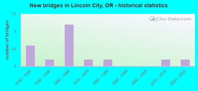
- New bridges - historical statistics
- 31940-1949
- 11950-1959
- 61960-1969
- 11970-1979
- 11980-1989
- 12010-2019
- 12020-2022


- Bridge Condition - Deck
- 8.3%Very good
- 41.7%Good
- 41.7%Satisfactory
- 8.3%Fair

- Bridge Condition - Superstructure
- 8.3%Very good
- 16.7%Good
- 66.7%Satisfactory
- 8.3%Fair

- Bridge Condition - Substructure
- 8.3%Very good
- 8.3%Good
- 41.7%Satisfactory
- 25.0%Fair
- 8.3%Poor
- 8.3%Serious

- Bridge Condition - Channel
- 8.3%Very good
- 33.3%Good
- 33.3%Satisfactory
- 16.7%Fair
- 8.3%Poor
Find on map >> Show street view
Structure Number: 922A009 11488, Location: 020 MI N LINCOLN C N C LT (Lat: 44.967583, Lng: -124.016200), Route carried "on" structure: US 101, Year Built: 1949, Status: Open, Structure Length: 3.05m (10.01ft), Average Daily Traffic: 19,538 (year 2020), Truck Traffic: 5%, Average Future Daily Traffic: 21,200 (year 2040), Design Load: HS 15, Features Intersected: Devils Lake Outlet
Minimum Vertical Clearance: 30+ m (98+ ft), Kilometerpoint: 184.881, Lanes on structure: 4, Base Highway Network: Yes, Owner: State Highway Agency, Approaching Roadway Width: 18.3m (60.0ft), Material/Design: Concrete continuous, Design/Construction: Tee Beam, Number Of Spans In Main Unit: 3, Length of Maximum Span: 18.3m (60.0ft), Curb or Sidewalk Widths: Left: 1.5m (4.9ft), Right: 1.5m (4.9ft), Curb-To-Curb Width: 18.3m (60.0ft), Out-to-Out Width: 22.3m (73.2ft)
Condition: Deck: Satisfactory, Superstructure: Satisfactory, Substructure: Satisfactory, Channel: Good, Operating Rating: 24.5 metric tons, Method Used To Determine Operating Rating: Load Factor (LF), Inventory Rating: 14.5 metric tons, Method Used To Determine Inventory Rating: Load Factor (LF), Structural Evaluation: High priority of corrective action, Deck Geometry: Somewhat better than minimum adequacy, Waterway Adequacy: Equal to present desirable criteria, Approach Roadway Alignment: Equal to present desirable criteria, Length Of Structure Improvement: 3.00m (9.84ft), Designated Inspection Frequency: Every 24 months, Inspection Date: January 2022, Bridge Improvement Cost: $320,000, Roadway Improvement Cost: $32,000, Total Project Cost: $512,000, Deck Structure Type: Concrete Cast-file-Place, Wearing Surface/Protective System: Wearing Surface: Monolithic Concrete
Find on map >> Show street view
Structure Number: 924A009 11817, Location: 005 MI W LINCOLN C S C LT (Lat: 44.925772, Lng: -124.013914), Route carried "on" structure: US 101, Year Built: 1945, Status: Open, Structure Length: 8.69m (28.51ft), Average Daily Traffic: 13,378 (year 2020), Truck Traffic: 5%, Average Future Daily Traffic: 14,900 (year 2040), Design Load: HS 15, Features Intersected: Schooner Creek
Minimum Vertical Clearance: 30+ m (98+ ft), Kilometerpoint: 190.176, Lanes on structure: 2, Base Highway Network: Yes, Owner: State Highway Agency, Approaching Roadway Width: 7.9m (25.9ft), Material/Design: Concrete continuous, Design/Construction: Tee Beam, Number Of Spans In Main Unit: 6, Length of Maximum Span: 21.3m (69.9ft), Curb or Sidewalk Widths: Left: 1.1m (3.6ft), Right: 1.1m (3.6ft), Curb-To-Curb Width: 7.9m (25.9ft), Out-to-Out Width: 11.0m (36.1ft)
Condition: Deck: Fair, Superstructure: Fair, Substructure: Fair, Channel: Good, Operating Rating: 21.1 metric tons, Method Used To Determine Operating Rating: Load and Resistance Factor Rating (LRFR) rating reported by rating factor(RF) method using HL-93 loadings, Inventory Rating: 16.2 metric tons, Method Used To Determine Inventory Rating: Load and Resistance Factor Rating (LRFR) rating reported by rating factor(RF) method using HL-93 loadings, Structural Evaluation: Meets minimum limits, Deck Geometry: High priority of corrective action, Waterway Adequacy: Equal to present desirable criteria, Approach Roadway Alignment: Equal to present desirable criteria, Length Of Structure Improvement: 8.70m (28.54ft), Designated Inspection Frequency: Every 24 months, Inspection Date: June 2021, Bridge Improvement Cost: $913,000, Roadway Improvement Cost: $91,000, Total Project Cost: $1,460,000, Deck Structure Type: Concrete Cast-file-Place, Wearing Surface/Protective System: Wearing Surface: Bituminous
Find on map >> Show street view
Structure Number: 925A009 11927, Location: 005 MI S LINCOLN CITY (Lat: 44.912400, Lng: -124.005047), Route carried "on" structure: US 101, Year Built: 1945, Status: Open, Structure Length: 6.40m (21.00ft), Average Daily Traffic: 12,177 (year 2020), Truck Traffic: 5%, Average Future Daily Traffic: 12,300 (year 2040), Design Load: HS 15, Features Intersected: Drift Creek
Minimum Vertical Clearance: 30+ m (98+ ft), Kilometerpoint: 191.946, Lanes on structure: 2, Base Highway Network: Yes, Owner: State Highway Agency, Approaching Roadway Width: 7.9m (25.9ft), Material/Design: Concrete continuous, Design/Construction: Tee Beam, Number Of Spans In Main Unit: 5, Length of Maximum Span: 21.3m (69.9ft), Curb or Sidewalk Widths: Left: 1.1m (3.6ft), Right: 1.1m (3.6ft), Curb-To-Curb Width: 7.9m (25.9ft), Out-to-Out Width: 10.7m (35.1ft)
Condition: Deck: Good, Superstructure: Satisfactory, Substructure: Fair, Channel: Satisfactory, Operating Rating: 40.8 metric tons, Method Used To Determine Operating Rating: Load Factor (LF), Inventory Rating: 24.5 metric tons, Method Used To Determine Inventory Rating: Load Factor (LF), Structural Evaluation: Somewhat better than minimum adequacy, Deck Geometry: High priority of corrective action, Waterway Adequacy: Equal to present desirable criteria, Approach Roadway Alignment: Equal to present desirable criteria, Length Of Structure Improvement: 6.40m (21.00ft), Designated Inspection Frequency: Every 24 months, Underwater Inspection Frequency: Every 36 months, Inspection Date: June 2021, Underwater Inspection Date: Febuary 2021, Bridge Improvement Cost: $672,000, Roadway Improvement Cost: $67,000, Total Project Cost: $1,076,000, Deck Structure Type: Concrete Cast-file-Place, Wearing Surface/Protective System: Wearing Surface: Bituminous
Find on map >> Show street view
Structure Number: 9463 009 1047, Location: 005 MI N HWY 9 JCT (Lat: 45.024272, Lng: -123.967619), Route carried "on" structure: US 101, Year Built: 1960, Status: Open, Structure Length: 5.18m (16.99ft), Average Daily Traffic: 4,307 (year 2020), Truck Traffic: 15%, Average Future Daily Traffic: 4,900 (year 2040), Design Load: HS 20, Features Intersected: Salmon River
Minimum Vertical Clearance: 30+ m (98+ ft), Kilometerpoint: 168.498, Lanes on structure: 2, Base Highway Network: Yes, Owner: State Highway Agency, Approaching Roadway Width: 9.1m (29.9ft), Material/Design: Concrete continuous, Design/Construction: Tee Beam, Number Of Spans In Main Unit: 3, Length of Maximum Span: 21.3m (69.9ft), Curb-To-Curb Width: 9.1m (29.9ft), Out-to-Out Width: 10.7m (35.1ft)
Condition: Deck: Satisfactory, Superstructure: Satisfactory, Substructure: Fair, Channel: Fair, Operating Rating: 22.4 metric tons, Method Used To Determine Operating Rating: Load and Resistance Factor Rating (LRFR) rating reported by rating factor(RF) method using HL-93 loadings, Inventory Rating: 17.2 metric tons, Method Used To Determine Inventory Rating: Load and Resistance Factor Rating (LRFR) rating reported by rating factor(RF) method using HL-93 loadings, Structural Evaluation: Meets minimum limits, Deck Geometry: Meets minimum limits, Waterway Adequacy: Equal to present desirable criteria, Approach Roadway Alignment: Equal to present desirable criteria, Designated Inspection Frequency: Every 24 months, Underwater Inspection Frequency: Every 24 months, Inspection Date: January 2021, Underwater Inspection Date: Febuary 2021, Deck Structure Type: Concrete Cast-file-Place, Wearing Surface/Protective System: Wearing Surface: Epoxy Overlay
Find on map >> Show street view
Structure Number: 9906 009 12016, Location: KERNVILLE (Lat: 44.899628, Lng: -124.007700), Route carried "on" structure: US 101, Year Built: 1973, Status: Open, Structure Length: 28.04m (91.99ft), Average Daily Traffic: 11,206 (year 2020), Truck Traffic: 6%, Average Future Daily Traffic: 12,500 (year 2040), Design Load: HS 20, Features Intersected: Siletz River
Minimum Vertical Clearance: 30+ m (98+ ft), Kilometerpoint: 193.379, Lanes on structure: 4, Base Highway Network: Yes, Owner: State Highway Agency, Approaching Roadway Width: 21.9m (71.9ft), Skew: 3 degrees, Navigation Control: Yes ( Vertical Clearance: 9.1m (29.9ft), Horizontal Clearance: 41.1m (134.8ft)), Material/Design: Prestressed concrete continuous, Design/Construction: Box Beam or Girders - Multiple, Number Of Spans In Main Unit: 6, Length of Maximum Span: 50.3m (165.0ft), Curb or Sidewalk Widths: Left: 1.5m (4.9ft), Right: 1.5m (4.9ft), Curb-To-Curb Width: 21.9m (71.9ft), Out-to-Out Width: 26.5m (86.9ft)
Condition: Deck: Satisfactory, Superstructure: Satisfactory, Substructure: Satisfactory, Channel: Good, Operating Rating: 33.0 metric tons, Method Used To Determine Operating Rating: Load and Resistance Factor Rating (LRFR) rating reported by rating factor(RF) method using HL-93 loadings, Inventory Rating: 25.6 metric tons, Method Used To Determine Inventory Rating: Load and Resistance Factor Rating (LRFR) rating reported by rating factor(RF) method using HL-93 loadings, Structural Evaluation: Equal to present minimum criteria, Deck Geometry: Superior to present desirable criteria, Waterway Adequacy: Equal to present desirable criteria, Approach Roadway Alignment: Equal to present desirable criteria, Designated Inspection Frequency: Every 24 months, Underwater Inspection Frequency: Every 60 months, Inspection Date: June 2021, Underwater Inspection Date: August 2020, Deck Structure Type: Concrete Cast-file-Place
Find on map >> Show street view
Structure Number: 12003 10102 386, Location: 010 MI EAST DELAKE (Lat: 44.961600, Lng: -124.002789), Route carried "on" structure: County highway , Year Built: 1968, Status: Temporarily open, Structure Length: 1.10m (3.61ft), Average Daily Traffic: 663 (year 2021), Truck Traffic: 10%, Average Future Daily Traffic: 849 (year 2041), Design Load: HS 20, Features Intersected: CREEK, Facility Carried by Structure: E DEVILS LAKE ROAD
Minimum Vertical Clearance: 30+ m (98+ ft), Kilometerpoint: 6.212, Lanes on structure: 2, Owner: County Highway Agency, Approaching Roadway Width: 6.7m (22.0ft), Material/Design: Prestressed concrete, Design/Construction: Slab, Number Of Spans In Main Unit: 1, Length of Maximum Span: 10.7m (35.1ft), Curb or Sidewalk Widths: Left: 0.2m (0.7ft), Right: 0.2m (0.7ft), Curb-To-Curb Width: 6.8m (22.3ft), Out-to-Out Width: 7.3m (24.0ft)
Condition: Deck: Satisfactory, Superstructure: Satisfactory, Substructure: Serious, Channel: Poor, Operating Rating: 54.4 metric tons, Method Used To Determine Operating Rating: Allowable Stress (AS), Inventory Rating: 49.9 metric tons, Method Used To Determine Inventory Rating: Allowable Stress (AS), Structural Evaluation: High priority of corrective action, Deck Geometry: Meets minimum limits, Waterway Adequacy: Meets minimum limits, Approach Roadway Alignment: Equal to present desirable criteria, Length Of Structure Improvement: 1.40m (4.59ft), Designated Inspection Frequency: Every 12 months, Underwater Inspection Frequency: Every 60 months, Inspection Date: July 2021, Underwater Inspection Date: April 2019, Bridge Improvement Cost: $150,000, Roadway Improvement Cost: $15,000, Total Project Cost: $240,000, Deck Structure Type: Other, Wearing Surface/Protective System: Wearing Surface: Bituminous
Find on map >> Show street view
Structure Number: 12010 101 22, Location: 030 MI NW OF OTIS JCTN (Lat: 45.042369, Lng: -123.990411), Route carried "on" structure: County highway , Year Built: 1958, Status: Open, Structure Length: 0.73m (2.40ft), Average Daily Traffic: 172 (year 2020), Truck Traffic: 10%, Average Future Daily Traffic: 225 (year 2040), Design Load: H 20, Features Intersected: CROWLEY CREEK, Facility Carried by Structure: THREE ROCKS ROAD
Minimum Vertical Clearance: 30+ m (98+ ft), Kilometerpoint: 3.541, Lanes on structure: 2, Owner: County Highway Agency, Approaching Roadway Width: 7.6m (24.9ft), Skew: 1 degrees, Material/Design: Wood or Timber, Design/Construction: Slab, Number Of Spans In Main Unit: 1, Length of Maximum Span: 7.0m (23.0ft), Curb-To-Curb Width: 6.9m (22.6ft), Out-to-Out Width: 7.3m (24.0ft)
Condition: Deck: Good, Superstructure: Satisfactory, Substructure: Poor, Channel: Satisfactory, Operating Rating: 44.4 metric tons, Method Used To Determine Operating Rating: Load and Resistance Factor Rating (LRFR) rating reported by rating factor(RF) method using HL-93 loadings, Inventory Rating: 34.3 metric tons, Method Used To Determine Inventory Rating: Load and Resistance Factor Rating (LRFR) rating reported by rating factor(RF) method using HL-93 loadings, Structural Evaluation: Meets minimum limits, Deck Geometry: Meets minimum limits, Waterway Adequacy: Equal to present minimum criteria, Approach Roadway Alignment: Equal to present desirable criteria, Designated Inspection Frequency: Every 24 months, Inspection Date: September 2020, Deck Structure Type: Wood or Timber, Wearing Surface/Protective System: Wearing Surface: Bituminous
Find on map >> Show street view
Structure Number: 12018A10801 006, Location: 020 MI EAST OF LINCOLN CT (Lat: 44.936500, Lng: -123.974681), Route carried "on" structure: County highway , Year Built: 1963, Status: Open, Structure Length: 2.07m (6.79ft), Average Daily Traffic: 231 (year 2020), Truck Traffic: 10%, Average Future Daily Traffic: 338 (year 2040), Design Load: HS 20, Features Intersected: SCHOONER CREEK, Facility Carried by Structure: ANDERSON CREEK RD
Minimum Vertical Clearance: 30+ m (98+ ft), Kilometerpoint: 0.097, Lanes on structure: 2, Owner: County Highway Agency, Approaching Roadway Width: 8.2m (26.9ft), Material/Design: Prestressed concrete, Design/Construction: Tee Beam, Number Of Spans In Main Unit: 1, Length of Maximum Span: 20.4m (66.9ft), Curb or Sidewalk Widths: Left: 0.2m (0.7ft), Right: 0.2m (0.7ft), Curb-To-Curb Width: 6.9m (22.6ft), Out-to-Out Width: 7.3m (24.0ft)
Condition: Deck: Good, Superstructure: Satisfactory, Substructure: Satisfactory, Channel: Satisfactory, Operating Rating: 78.0 metric tons, Method Used To Determine Operating Rating: Allowable Stress (AS), Inventory Rating: 47.2 metric tons, Method Used To Determine Inventory Rating: Allowable Stress (AS), Structural Evaluation: Equal to present minimum criteria, Deck Geometry: Meets minimum limits, Waterway Adequacy: Equal to present desirable criteria, Approach Roadway Alignment: Equal to present desirable criteria, Designated Inspection Frequency: Every 24 months, Inspection Date: September 2020, Deck Structure Type: Other, Wearing Surface/Protective System: Wearing Surface: Bituminous
Find on map >> Show street view
Structure Number: 12019A10901 202, Location: 010 MI E OF KERNVILLE (Lat: 44.916611, Lng: -123.981511), Route carried "on" structure: County highway , Year Built: 1968, Status: Open, Structure Length: 4.42m (14.50ft), Average Daily Traffic: 326 (year 2020), Truck Traffic: 10%, Average Future Daily Traffic: 382 (year 2040), Design Load: HS 20, Features Intersected: DRIFT CREEK NORTH, Facility Carried by Structure: DRIFT CREEK ROAD
Minimum Vertical Clearance: 30+ m (98+ ft), Kilometerpoint: 3.251, Lanes on structure: 2, Owner: County Highway Agency, Approaching Roadway Width: 8.5m (27.9ft), Material/Design: Prestressed concrete, Design/Construction: Tee Beam, Number Of Spans In Main Unit: 1, Number Of Approach Spans: 3, Length of Maximum Span: 20.1m (65.9ft), Curb-To-Curb Width: 6.8m (22.3ft), Out-to-Out Width: 7.3m (24.0ft)
Condition: Deck: Good, Superstructure: Good, Substructure: Satisfactory, Channel: Fair, Operating Rating: 89.8 metric tons, Method Used To Determine Operating Rating: Load Factor (LF), Inventory Rating: 53.5 metric tons, Method Used To Determine Inventory Rating: Load Factor (LF), Structural Evaluation: Equal to present minimum criteria, Deck Geometry: Meets minimum limits, Waterway Adequacy: Equal to present desirable criteria, Approach Roadway Alignment: Equal to present desirable criteria, Designated Inspection Frequency: Every 24 months, Underwater Inspection Frequency: Every 60 months, Inspection Date: September 2020, Underwater Inspection Date: June 2021, Deck Structure Type: Other, Wearing Surface/Protective System: Wearing Surface: Bituminous
Find on map >> Show street view
Structure Number: 13491 039 00004, Location: 001 MI E HWY 101 (Lat: 45.020853, Lng: -123.973894), Route carried "on" structure: State highway 18, Year Built: 1962, Status: Open, Structure Length: 5.68m (18.64ft), Average Daily Traffic: 10,419 (year 2020), Truck Traffic: 7%, Average Future Daily Traffic: 11,700 (year 2040), Design Load: HS 20, Features Intersected: US 101 (Hwy 9)
Minimum Vertical Clearance: 30+ m (98+ ft), Kilometerpoint: 0.064, Lanes on structure: 2, Lanes under structure: 2, Base Highway Network: Yes, Owner: State Highway Agency, Approaching Roadway Width: 15.2m (49.9ft), Skew: 3 degrees, Material/Design: Concrete continuous, Design/Construction: Tee Beam, Number Of Spans In Main Unit: 3, Length of Maximum Span: 25.9m (85.0ft), Curb-To-Curb Width: 15.2m (49.9ft), Out-to-Out Width: 16.8m (55.1ft)
Condition: Deck: Satisfactory, Superstructure: Satisfactory, Substructure: Good, Operating Rating: 27.9 metric tons, Method Used To Determine Operating Rating: Load and Resistance Factor Rating (LRFR) rating reported by rating factor(RF) method using HL-93 loadings, Inventory Rating: 21.4 metric tons, Method Used To Determine Inventory Rating: Load and Resistance Factor Rating (LRFR) rating reported by rating factor(RF) method using HL-93 loadings, Structural Evaluation: Somewhat better than minimum adequacy, Deck Geometry: Superior to present desirable criteria, Underclear: Equal to present minimum criteria, Approach Roadway Alignment: Equal to present desirable criteria, Designated Inspection Frequency: Every 24 months, Inspection Date: November 2020, Deck Structure Type: Concrete Cast-file-Place, Wearing Surface/Protective System: Wearing Surface: Epoxy Overlay
Find on map >> Show street view
Structure Number: 22244 009 10488, Location: MP 104.88 (Lat: 45.022861, Lng: -123.970772), Route carried "on" structure: US 101, Year Built: 2015, Status: Open, Structure Length: 0.82m (2.69ft), Average Daily Traffic: 4,307 (year 2020), Truck Traffic: 15%, Average Future Daily Traffic: 4,900 (year 2040), Design Load: HL 93, Features Intersected: Fraser Creek
Minimum Vertical Clearance: 30+ m (98+ ft), Kilometerpoint: 168.788, Lanes on structure: 2, Owner: State Highway Agency, Approaching Roadway Width: 11.0m (36.1ft), Material/Design: Concrete continuous, Design/Construction: Culvert, Number Of Spans In Main Unit: 1, Length of Maximum Span: 3.7m (12.1ft)
Condition: Channel: Good, Culverts: Good, Operating Rating: 60.9 metric tons, Method Used To Determine Operating Rating: Load and Resistance Factor Rating (LRFR) rating reported by rating factor(RF) method using HL-93 loadings, Inventory Rating: 47.0 metric tons, Method Used To Determine Inventory Rating: Load and Resistance Factor Rating (LRFR) rating reported by rating factor(RF) method using HL-93 loadings, Structural Evaluation: Better than present minimum criteria, Waterway Adequacy: Equal to present desirable criteria, Approach Roadway Alignment: Equal to present desirable criteria, Designated Inspection Frequency: Every 24 months, Inspection Date: January 2021
Find on map >> Show street view
Structure Number: 23921 000 00105, Location: 000 WEST SIDE DEVILS LAKE (Lat: 44.983056, Lng: -123.998056), Route carried "on" structure: County highway , Year Built: 2020, Status: Open, Structure Length: 1.22m (4.00ft), Average Daily Traffic: 2,472 (year 2019), Truck Traffic: 10%, Average Future Daily Traffic: 3,502 (year 2039), Design Load: HL 93, Features Intersected: Devils Lake Creek, Facility Carried by Structure: W Devils Lake Rd
Minimum Vertical Clearance: 30+ m (98+ ft), Kilometerpoint: 1.690, Lanes on structure: 2, Owner: City or Municipal Highway Agency, Approaching Roadway Width: 8.5m (27.9ft), Material/Design: Prestressed concrete, Design/Construction: Slab, Number Of Spans In Main Unit: 1, Length of Maximum Span: 12.2m (40.0ft), Curb-To-Curb Width: 8.5m (27.9ft), Out-to-Out Width: 8.5m (27.9ft)
Condition: Deck: Very good, Superstructure: Very good, Substructure: Very good, Channel: Very good, Operating Rating: 50.9 metric tons, Method Used To Determine Operating Rating: Load and Resistance Factor Rating (LRFR) rating reported by rating factor(RF) method using HL-93 loadings, Inventory Rating: 39.2 metric tons, Method Used To Determine Inventory Rating: Load and Resistance Factor Rating (LRFR) rating reported by rating factor(RF) method using HL-93 loadings, Structural Evaluation: Equal to present desirable criteria, Deck Geometry: Meets minimum limits, Waterway Adequacy: Equal to present desirable criteria, Approach Roadway Alignment: Equal to present desirable criteria, Designated Inspection Frequency: Every 24 months, Inspection Date: December 2020, Wearing Surface/Protective System: Wearing Surface: Bituminous, Membrane: Preformed Fabric
Find on map >> Show street view
Structure Number: 41C08A11001 001, Location: 006 MI E OF HWY101-CO#101 (Lat: 44.920761, Lng: -123.999431), Route carried "on" structure: County highway , Year Built: 1981, Status: Open, Structure Length: 2.71m (8.89ft), Average Daily Traffic: 72 (year 2020), Average Future Daily Traffic: 102 (year 2040), Design Load: HS 20, Features Intersected: DRIFT CREEK NORTH, Facility Carried by Structure: GORTON ROAD
Minimum Vertical Clearance: 30+ m (98+ ft), Kilometerpoint: 0.016, Lanes on structure: 1, Owner: County Highway Agency, Approaching Roadway Width: 4.9m (16.1ft), Material/Design: Prestressed concrete, Design/Construction: Box Beam or Girders - Multiple, Number Of Spans In Main Unit: 1, Length of Maximum Span: 26.8m (87.9ft), Curb-To-Curb Width: 4.7m (15.4ft), Out-to-Out Width: 4.9m (16.1ft)
Condition: Deck: Good, Superstructure: Good, Substructure: Satisfactory, Channel: Satisfactory, Operating Rating: 79.8 metric tons, Method Used To Determine Operating Rating: Load Factor (LF), Inventory Rating: 48.1 metric tons, Method Used To Determine Inventory Rating: Load Factor (LF), Structural Evaluation: Equal to present minimum criteria, Deck Geometry: Better than present minimum criteria, Waterway Adequacy: Equal to present desirable criteria, Approach Roadway Alignment: Equal to present desirable criteria, Designated Inspection Frequency: Every 24 months, Inspection Date: September 2020, Deck Structure Type: Other, Wearing Surface/Protective System: Wearing Surface: Bituminous
Find on map >> Show street view
Structure Number: 13491 039 00004, Location: 001 MI E HWY 101 (Lat: 45.020853, Lng: -123.973894), Route carried "under" structure: US 101, Year Built: 1962, Structure Length: 0. m, Average Daily Traffic: 13,181 (year 2020), Truck Traffic: 15%, Features Intersected: US 101 (Hwy 9), Facility Carried by Structure: OR 18 (Hwy 39)
Minimum Vertical Clearance: 5.08m (16.67ft), Kilometerpoint: 169.126, Lanes on structure: 2, Lanes under structure: 2, Material/Design: Concrete continuous, Design/Construction: Tee Beam, Length of Maximum Span: 25.9m (85.0ft)