Bridge Statistics for Lee Mont, Virginia (VA)
Condition, Traffic, Stress, Structural Evaluation, Project Costs
- National Bridge Inventory (NBI) Statistics
- 12Number of bridges
- 154ft / 46.7mTotal length
- $120,000Total costs
- 175,378Total average daily traffic
- 8,788Total average daily truck traffic
- 240,711Total future (year 2040) average daily traffic
- National Bridge Inventory (NBI) Registered Bridges for Lee Mont
- No street view available for this location
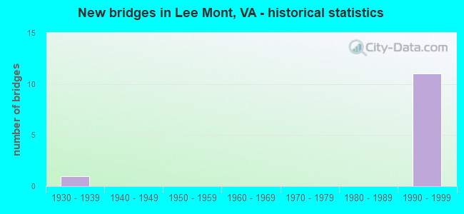
- New bridges - historical statistics
- 11930-1939
- 111990-1999


- Bridge Condition - Deck
- 44.4%Good
- 55.6%Satisfactory

- Bridge Condition - Superstructure
- 66.7%Good
- 33.3%Satisfactory

- Bridge Condition - Substructure
- 55.6%Good
- 33.3%Satisfactory
- 11.1%Fair

- Bridge Condition - Channel
- 11.1%Very good
- 22.2%Good
- 33.3%Satisfactory
- 33.3%Fair

- Bridge Condition - Culverts
- 66.7%Satisfactory
- 33.3%Fair
Find on map >> Show street view
Structure Number: 23278, Location: 3.35 MI. FR. CHESTFLD. CO (Lat: 37.268150, Lng: -77.324294), Route carried "on" structure: Interstate 295, Year Built: 1991, Status: Open, Structure Length: 5.85m (19.19ft), Average Daily Traffic: 9,586 (year 2020), Truck Traffic: 22%, Average Future Daily Traffic: 13,420 (year 2040), Design Load: HS 20+Mod, Features Intersected: WESTERN ST & NS RWY
Minimum Vertical Clearance: 30+ m (98+ ft), Kilometerpoint: 69.348, Lanes on structure: 2, Lanes under structure: 2, Base Highway Network: Yes, Owner: State Highway Agency, Approaching Roadway Width: 12.5m (41.0ft), Material/Design: Steel continuous, Design/Construction: Stringer/Multi-beam, Number Of Spans In Main Unit: 2, Length of Maximum Span: 30.2m (99.1ft), Curb-To-Curb Width: 12.3m (40.4ft), Out-to-Out Width: 13.4m (44.0ft)
Condition: Deck: Satisfactory, Superstructure: Good, Substructure: Satisfactory, Operating Rating: 84.4 metric tons, Method Used To Determine Operating Rating: Load and Resistance Factor (LRFR), Inventory Rating: 64.4 metric tons, Method Used To Determine Inventory Rating: Load and Resistance Factor (LRFR), Structural Evaluation: Equal to present minimum criteria, Deck Geometry: Better than present minimum criteria, Underclear: Meets minimum limits, Approach Roadway Alignment: Equal to present desirable criteria, Designated Inspection Frequency: Every 24 months, Inspection Date: October 2021, Deck Structure Type: Concrete Cast-file-Place, Wearing Surface/Protective System: Deck Protection: Epoxy Coated Reinforcing
Find on map >> Show street view
Structure Number: 23279, Location: 3.35 MI. FR. CHESTFEILD (Lat: 37.267928, Lng: -77.324536), Route carried "on" structure: Interstate 295, Year Built: 1991, Status: Open, Structure Length: 5.85m (19.19ft), Average Daily Traffic: 9,489 (year 2020), Truck Traffic: 24%, Average Future Daily Traffic: 13,285 (year 2040), Design Load: HS 20+Mod, Features Intersected: WESTERN ST & NS RWY
Minimum Vertical Clearance: 30+ m (98+ ft), Kilometerpoint: 69.348, Lanes on structure: 3, Lanes under structure: 2, Base Highway Network: Yes, Owner: State Highway Agency, Approaching Roadway Width: 18.0m (59.1ft), Material/Design: Steel continuous, Design/Construction: Stringer/Multi-beam, Number Of Spans In Main Unit: 2, Length of Maximum Span: 30.2m (99.1ft), Curb-To-Curb Width: 17.8m (58.4ft), Out-to-Out Width: 18.8m (61.7ft)
Condition: Deck: Satisfactory, Superstructure: Good, Substructure: Satisfactory, Operating Rating: 85.3 metric tons, Method Used To Determine Operating Rating: Load and Resistance Factor (LRFR), Inventory Rating: 65.3 metric tons, Method Used To Determine Inventory Rating: Load and Resistance Factor (LRFR), Structural Evaluation: Equal to present minimum criteria, Deck Geometry: Better than present minimum criteria, Underclear: High priority of corrective action, Approach Roadway Alignment: Equal to present desirable criteria, Designated Inspection Frequency: Every 24 months, Inspection Date: October 2021, Deck Structure Type: Concrete Cast-file-Place, Wearing Surface/Protective System: Deck Protection: Epoxy Coated Reinforcing
Find on map >> Show street view
Structure Number: 23337, Location: .25 From 732 & 1.9 To 632 (Lat: 37.985897, Lng: -78.050717), Route carried "on" structure: County highway 642, Year Built: 1992, Status: Open, Structure Length: 1.16m (3.81ft), Average Daily Traffic: 144 (year 2019), Average Future Daily Traffic: 159 (year 2040), Design Load: HS 20+Mod, Features Intersected: Br of South Anna River, Facility Carried by Structure: Bickley Road
Minimum Vertical Clearance: 30+ m (98+ ft), Kilometerpoint: 3.047, Lanes on structure: 2, Owner: State Highway Agency, Approaching Roadway Width: 5.2m (17.1ft), Material/Design: Concrete, Design/Construction: Culvert, Number Of Spans In Main Unit: 3, Length of Maximum Span: 3.7m (12.1ft)
Condition: Channel: Fair, Culverts: Fair, Operating Rating: 69.9 metric tons, Method Used To Determine Operating Rating: Load Factor (LF), Inventory Rating: 41.7 metric tons, Method Used To Determine Inventory Rating: Load Factor (LF), Structural Evaluation: Somewhat better than minimum adequacy, Waterway Adequacy: Better than present minimum criteria, Approach Roadway Alignment: Equal to present desirable criteria, Designated Inspection Frequency: Every 24 months, Inspection Date: March 2021
Find on map >> Show street view
Structure Number: 23338, Location: 00.35 2677 / 00.50 613 (Lat: 38.767094, Lng: -77.164083), Route carried "on" structure: County highway 289, Year Built: 1991, Status: Open, Structure Length: 1.43m (4.69ft), Average Daily Traffic: 39,370 (year 2020), Truck Traffic: 1%, Average Future Daily Traffic: 52,135 (year 2040), Design Load: HS 20, Features Intersected: LONG BRANCH, Facility Carried by Structure: FRAN/SPRNGFLD PKWY
Minimum Vertical Clearance: 30+ m (98+ ft), Kilometerpoint: 0.000, Lanes on structure: 6, Base Highway Network: Yes, Owner: State Highway Agency, Approaching Roadway Width: 41.5m (136.2ft), Skew: 32 degrees, Material/Design: Concrete, Design/Construction: Culvert, Number Of Spans In Main Unit: 4, Length of Maximum Span: 3.0m (9.8ft)
Condition: Channel: Satisfactory, Culverts: Satisfactory, Operating Rating: 89.8 metric tons, Method Used To Determine Operating Rating: Load Factor (LF), Inventory Rating: 89.7 metric tons, Method Used To Determine Inventory Rating: Load Factor (LF), Structural Evaluation: Equal to present minimum criteria, Waterway Adequacy: Equal to present minimum criteria, Approach Roadway Alignment: Equal to present desirable criteria, Length Of Structure Improvement: 0.30m (0.98ft), Designated Inspection Frequency: Every 24 months, Inspection Date: July 2020, Bridge Improvement Cost: $44,000, Roadway Improvement Cost: $66,000, Total Project Cost: $120,000 ( Estimate for 2014)
Find on map >> Show street view
Structure Number: 23339, Location: 2.05 TO R675&0.95 TO R650 (Lat: 37.387567, Lng: -82.032417), Route carried "on" structure: County highway 651, Year Built: 1992, Status: Open, Structure Length: 1.01m (3.31ft), Average Daily Traffic: 311 (year 2015), Average Future Daily Traffic: 350 (year 2040), Design Load: HS 20, Features Intersected: BUSHY CREEK, Facility Carried by Structure: OLD LESTER'S FORK
Minimum Vertical Clearance: 30+ m (98+ ft), Kilometerpoint: 7.321, Lanes on structure: 2, Owner: State Highway Agency, Approaching Roadway Width: 5.2m (17.1ft), Skew: 5 degrees, Material/Design: Concrete, Design/Construction: Slab, Number Of Spans In Main Unit: 1, Length of Maximum Span: 9.1m (29.9ft), Curb-To-Curb Width: 7.6m (24.9ft), Out-to-Out Width: 8.5m (27.9ft)
Condition: Deck: Satisfactory, Superstructure: Satisfactory, Substructure: Satisfactory, Channel: Fair, Operating Rating: 89.8 metric tons, Method Used To Determine Operating Rating: Load and Resistance Factor (LRFR), Inventory Rating: 88.9 metric tons, Method Used To Determine Inventory Rating: Load and Resistance Factor (LRFR), Structural Evaluation: Equal to present minimum criteria, Deck Geometry: Somewhat better than minimum adequacy, Waterway Adequacy: Better than present minimum criteria, Approach Roadway Alignment: Better than present minimum criteria, Designated Inspection Frequency: Every 24 months, Inspection Date: Febuary 2022, Deck Structure Type: Concrete Cast-file-Place
Find on map >> Show street view
Structure Number: 23442, Location: 0.10-Rt 850 / 0.70-Rt 662 (Lat: 37.347994, Lng: -79.051158), Route carried "on" structure: County highway 660, Year Built: 1992, Status: Open, Structure Length: 3.66m (12.01ft), Average Daily Traffic: 606 (year 2020), Truck Traffic: 1%, Average Future Daily Traffic: 667 (year 2040), Features Intersected: NS Railway, Facility Carried by Structure: Oxford Furnace Rd.
Minimum Vertical Clearance: 30+ m (98+ ft), Kilometerpoint: 7.691, Lanes on structure: 2, Owner: State Highway Agency, Approaching Roadway Width: 11.6m (38.1ft), Material/Design: Steel, Design/Construction: Stringer/Multi-beam, Number Of Spans In Main Unit: 1, Length of Maximum Span: 36.6m (120.1ft), Curb-To-Curb Width: 8.5m (27.9ft), Out-to-Out Width: 9.5m (31.2ft)
Condition: Deck: Good, Superstructure: Good, Substructure: Good, Operating Rating: 47.2 metric tons, Method Used To Determine Operating Rating: Load and Resistance Factor (LRFR), Inventory Rating: 36.3 metric tons, Method Used To Determine Inventory Rating: Load and Resistance Factor (LRFR), Structural Evaluation: Better than present minimum criteria, Deck Geometry: Somewhat better than minimum adequacy, Underclear: Better than present minimum criteria, Approach Roadway Alignment: Equal to present desirable criteria, Designated Inspection Frequency: Every 24 months, Inspection Date: May 2020, Deck Structure Type: Concrete Cast-file-Place, Wearing Surface/Protective System: Wearing Surface: Epoxy Overlay, Deck Protection: Epoxy Coated Reinforcing
Find on map >> Show street view
Structure Number: 23447, Location: 0.00ECL CHAR/0.00ALBEM CO (Lat: 38.034747, Lng: -78.459219), Route carried "on" structure: US 250, Year Built: 1992, Status: Open, Structure Length: 11.95m (39.21ft), Average Daily Traffic: 43,850 (year 2020), Truck Traffic: 2%, Average Future Daily Traffic: 61,390 (year 2040), Design Load: HS 20+Mod, Features Intersected: RIVANNA RIVER, Facility Carried by Structure: RICHMOND ROAD
Minimum Vertical Clearance: 30+ m (98+ ft), Kilometerpoint: 157.360, Lanes on structure: 7, Base Highway Network: Yes, Owner: State Highway Agency, Approaching Roadway Width: 20.1m (65.9ft), Skew: 21 degrees, Material/Design: Steel continuous, Design/Construction: Stringer/Multi-beam, Number Of Spans In Main Unit: 3, Length of Maximum Span: 41.5m (136.2ft), Curb or Sidewalk Widths: Left: 2.4m (7.9ft), Right: 2.4m (7.9ft), Curb-To-Curb Width: 27.4m (89.9ft), Out-to-Out Width: 34.4m (112.9ft)
Condition: Deck: Satisfactory, Superstructure: Satisfactory, Substructure: Good, Channel: Satisfactory, Operating Rating: 46.3 metric tons, Method Used To Determine Operating Rating: Load and Resistance Factor (LRFR), Inventory Rating: 35.4 metric tons, Method Used To Determine Inventory Rating: Load and Resistance Factor (LRFR), Structural Evaluation: Equal to present minimum criteria, Deck Geometry: Meets minimum limits, Waterway Adequacy: Equal to present minimum criteria, Approach Roadway Alignment: Equal to present desirable criteria, Designated Inspection Frequency: Every 24 months, Inspection Date: June 2020, Deck Structure Type: Concrete Cast-file-Place, Wearing Surface/Protective System: Wearing Surface: Epoxy Overlay, Deck Protection: Epoxy Coated Reinforcing
Find on map >> Show street view
Structure Number: 2345, Location: .23 From 701 & .07 To 627 (Lat: 38.304597, Lng: -77.965678), Route carried "on" structure: County highway 617, Year Built: 1992, Status: Open, Structure Length: 1.62m (5.31ft), Average Daily Traffic: 351 (year 2017), Average Future Daily Traffic: 367 (year 2040), Design Load: HS 20+Mod, Features Intersected: Mountain Run, Facility Carried by Structure: Everona Road
Minimum Vertical Clearance: 30+ m (98+ ft), Kilometerpoint: 5.310, Lanes on structure: 2, Owner: State Highway Agency, Approaching Roadway Width: 7.3m (24.0ft), Material/Design: Concrete, Design/Construction: Culvert, Number Of Spans In Main Unit: 4, Length of Maximum Span: 3.7m (12.1ft)
Condition: Channel: Fair, Culverts: Satisfactory, Operating Rating: 66.2 metric tons, Method Used To Determine Operating Rating: Load Factor (LF), Inventory Rating: 39.9 metric tons, Method Used To Determine Inventory Rating: Load Factor (LF), Structural Evaluation: Equal to present minimum criteria, Waterway Adequacy: Equal to present minimum criteria, Approach Roadway Alignment: Equal to present desirable criteria, Designated Inspection Frequency: Every 24 months, Inspection Date: August 2020
Find on map >> Show street view
Structure Number: 23546, Location: 1.34 Fr 702 & 0.56 To 652 (Lat: 37.414342, Lng: -77.644103), Route carried "on" structure: US 360, Year Built: 1992, Status: Open, Structure Length: 4.95m (16.24ft), Average Daily Traffic: 33,924 (year 2020), Truck Traffic: 7%, Average Future Daily Traffic: 47,494 (year 2040), Design Load: HS 20+Mod, Features Intersected: SWIFT CREEK
Minimum Vertical Clearance: 30+ m (98+ ft), Kilometerpoint: 202.718, Lanes on structure: 2, Base Highway Network: Yes, Owner: State Highway Agency, Approaching Roadway Width: 17.1m (56.1ft), Skew: 3 degrees, Material/Design: Steel continuous, Design/Construction: Stringer/Multi-beam, Number Of Spans In Main Unit: 3, Length of Maximum Span: 20.0m (65.6ft), Curb-To-Curb Width: 17.1m (56.1ft), Out-to-Out Width: 18.1m (59.4ft)
Condition: Deck: Good, Superstructure: Good, Substructure: Good, Channel: Satisfactory, Operating Rating: 52.6 metric tons, Method Used To Determine Operating Rating: Load and Resistance Factor (LRFR), Inventory Rating: 40.8 metric tons, Method Used To Determine Inventory Rating: Load and Resistance Factor (LRFR), Structural Evaluation: Better than present minimum criteria, Deck Geometry: Superior to present desirable criteria, Waterway Adequacy: Equal to present desirable criteria, Approach Roadway Alignment: Equal to present desirable criteria, Designated Inspection Frequency: Every 24 months, Inspection Date: Febuary 2021, Deck Structure Type: Concrete Cast-file-Place, Wearing Surface/Protective System: Deck Protection: Epoxy Coated Reinforcing
Find on map >> Show street view
Structure Number: 23547, Location: 4.9MTO80 & .78MTOECLLEBAN (Lat: 36.908647, Lng: -82.039542), Route carried "on" structure: Business US 19, Year Built: 1936, Year Reconstructed: 1995, Status: Open, Structure Length: 4.60m (15.09ft), Average Daily Traffic: 4,685 (year 2020), Truck Traffic: 2%, Average Future Daily Traffic: 5,154 (year 2040), Design Load: HS 20+Mod, Features Intersected: BIG CEDAR CREEK
Minimum Vertical Clearance: 30+ m (98+ ft), Kilometerpoint: 61.222, Lanes on structure: 2, Base Highway Network: Yes, Owner: State Highway Agency, Approaching Roadway Width: 7.3m (24.0ft), Material/Design: Steel, Design/Construction: Stringer/Multi-beam, Number Of Spans In Main Unit: 4, Length of Maximum Span: 11.6m (38.1ft), Curb-To-Curb Width: 7.9m (25.9ft), Out-to-Out Width: 8.5m (27.9ft)
Condition: Deck: Satisfactory, Superstructure: Satisfactory, Substructure: Fair, Channel: Very good, Operating Rating: 83.5 metric tons, Method Used To Determine Operating Rating: Load and Resistance Factor (LRFR), Inventory Rating: 64.4 metric tons, Method Used To Determine Inventory Rating: Load and Resistance Factor (LRFR), Structural Evaluation: Somewhat better than minimum adequacy, Deck Geometry: High priority of corrective action, Waterway Adequacy: Better than present minimum criteria, Approach Roadway Alignment: Better than present minimum criteria, Length Of Structure Improvement: 4.63m (15.19ft), Designated Inspection Frequency: Every 24 months, Inspection Date: March 2021, Deck Structure Type: Concrete Cast-file-Place
Find on map >> Show street view
Structure Number: 23548, Location: 0.50HOLLRD/1.10LND BR RD (Lat: 36.788128, Lng: -76.070764), Route carried "on" structure: City street , Year Built: 1992, Status: Open, Structure Length: 2.29m (7.51ft), Average Daily Traffic: 16,531 (year 2020), Truck Traffic: 2%, Average Future Daily Traffic: 23,145 (year 2040), Design Load: HS 20+Mod, Features Intersected: WEST NECK CREEK, Facility Carried by Structure: EBL DAM NECK ROAD
Minimum Vertical Clearance: 30+ m (98+ ft), Kilometerpoint: 0.000, Lanes on structure: 2, Base Highway Network: Yes, Owner: City or Municipal Highway Agency, Approaching Roadway Width: 8.5m (27.9ft), Skew: 3 degrees, Material/Design: Prestressed concrete, Design/Construction: Stringer/Multi-beam, Number Of Spans In Main Unit: 1, Length of Maximum Span: 22.9m (75.1ft), Curb or Sidewalk Widths: Left: 1.2m (3.9ft), Right: 0.0m, Curb-To-Curb Width: 9.8m (32.2ft), Out-to-Out Width: 12.4m (40.7ft)
Condition: Deck: Good, Superstructure: Good, Substructure: Good, Channel: Good, Operating Rating: 99.8 metric tons, Method Used To Determine Operating Rating: Load and Resistance Factor (LRFR), Inventory Rating: 79.6 metric tons, Method Used To Determine Inventory Rating: Load and Resistance Factor (LRFR), Structural Evaluation: Better than present minimum criteria, Deck Geometry: Meets minimum limits, Waterway Adequacy: Equal to present desirable criteria, Approach Roadway Alignment: Equal to present desirable criteria, Designated Inspection Frequency: Every 24 months, Inspection Date: Febuary 2021, Deck Structure Type: Concrete Cast-file-Place, Wearing Surface/Protective System: Wearing Surface: Monolithic Concrete, Deck Protection: Epoxy Coated Reinforcing
Find on map >> Show street view
Structure Number: 23549, Location: 0.50HOLLRD/1.10LDN BR RD (Lat: 36.788319, Lng: -76.070875), Route carried "on" structure: City street , Year Built: 1992, Status: Open, Structure Length: 2.29m (7.51ft), Average Daily Traffic: 16,531 (year 2020), Truck Traffic: 2%, Average Future Daily Traffic: 23,145 (year 2040), Design Load: HS 20+Mod, Features Intersected: WEST NECK CREEK, Facility Carried by Structure: WBL DAM NECK ROAD
Minimum Vertical Clearance: 30+ m (98+ ft), Kilometerpoint: 0.000, Lanes on structure: 2, Owner: City or Municipal Highway Agency, Approaching Roadway Width: 8.5m (27.9ft), Skew: 3 degrees, Material/Design: Prestressed concrete, Design/Construction: Stringer/Multi-beam, Number Of Spans In Main Unit: 1, Length of Maximum Span: 22.9m (75.1ft), Curb or Sidewalk Widths: Left: 0.0m, Right: 2.4m (7.9ft), Curb-To-Curb Width: 9.8m (32.2ft), Out-to-Out Width: 13.6m (44.6ft)
Condition: Deck: Good, Superstructure: Good, Substructure: Good, Channel: Good, Operating Rating: 99.8 metric tons, Method Used To Determine Operating Rating: Load and Resistance Factor (LRFR), Inventory Rating: 80.3 metric tons, Method Used To Determine Inventory Rating: Load and Resistance Factor (LRFR), Structural Evaluation: Better than present minimum criteria, Deck Geometry: Meets minimum limits, Waterway Adequacy: Equal to present desirable criteria, Approach Roadway Alignment: Equal to present desirable criteria, Designated Inspection Frequency: Every 24 months, Inspection Date: Febuary 2021, Deck Structure Type: Concrete Cast-file-Place, Wearing Surface/Protective System: Wearing Surface: Monolithic Concrete, Deck Protection: Epoxy Coated Reinforcing