Bridge Statistics for Lakeshore Gardens-Hidden Acres, Texas (TX)
Condition, Traffic, Stress, Structural Evaluation, Project Costs
- National Bridge Inventory (NBI) Statistics
- 16Number of bridges
- 131ft / 39.5mTotal length
- $476,000Total costs
- 76,873Total average daily traffic
- 15,947Total average daily truck traffic
- National Bridge Inventory (NBI) Registered Bridges for Lakeshore Gardens-Hidden Acres
- No street view available for this location
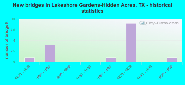
- New bridges - historical statistics
- 11920-1929
- 41930-1939
- 11960-1969
- 91970-1979
- 11990-1999

- Reconstructed bridges - Historical Statistics
- 11940-1949
- 21950-1959


- Bridge Condition - Deck
- 20.0%Very good
- 60.0%Good
- 20.0%Satisfactory

- Bridge Condition - Superstructure
- 20.0%Very good
- 60.0%Good
- 20.0%Poor

- Bridge Condition - Substructure
- 80.0%Good
- 20.0%Fair

- Bridge Condition - Channel
- 30.0%Good
- 60.0%Satisfactory
- 10.0%Fair

- Bridge Condition - Culverts
- 12.5%Good
- 75.0%Satisfactory
- 12.5%Fair
Find on map >> Show street view
Structure Number: 161490007402133, Location: 0.8 MI N OF SAN PAT C/L (Lat: 28.161783, Lng: -97.859272), Route carried "on" structure: Interstate 37, Year Built: 1971, Status: Open, Structure Length: 6.64m (21.78ft), Average Daily Traffic: 10,998 (year 2019), Truck Traffic: 20%, Average Future Daily Traffic: 11,190 (year 2033), Design Load: HS 20, Features Intersected: FM 888
Minimum Vertical Clearance: 30+ m (98+ ft), Kilometerpoint: 1.262, Lanes on structure: 2, Lanes under structure: 2, Base Highway Network: Yes, Owner: State Highway Agency, Approaching Roadway Width: 11.6m (38.1ft), Material/Design: Prestressed concrete, Design/Construction: Stringer/Multi-beam, Number Of Spans In Main Unit: 1, Number Of Approach Spans: 2, Length of Maximum Span: 26.8m (87.9ft), Curb-To-Curb Width: 13.0m (42.7ft), Out-to-Out Width: 13.5m (44.3ft)
Condition: Deck: Good, Superstructure: Good, Substructure: Good, Operating Rating: 68.0 metric tons, Method Used To Determine Operating Rating: Load Factor (LF), Inventory Rating: 39.9 metric tons, Method Used To Determine Inventory Rating: Load Factor (LF), Structural Evaluation: Better than present minimum criteria, Deck Geometry: Superior to present desirable criteria, Underclear: Superior to present desirable criteria, Approach Roadway Alignment: Equal to present desirable criteria, Designated Inspection Frequency: Every 24 months, Inspection Date: May 2020, Deck Structure Type: Concrete Cast-file-Place, Wearing Surface/Protective System: Wearing Surface: Bituminous
Find on map >> Show street view
Structure Number: 161490007402134, Location: 0.8 MI N OF SAN PAT C/L (Lat: 28.161836, Lng: -97.859178), Route carried "on" structure: Interstate 37, Year Built: 1971, Status: Open, Structure Length: 6.64m (21.78ft), Average Daily Traffic: 9,211 (year 2019), Truck Traffic: 20%, Average Future Daily Traffic: 11,190 (year 2033), Design Load: HS 20, Features Intersected: FM 888
Minimum Vertical Clearance: 30+ m (98+ ft), Kilometerpoint: 1.265, Lanes on structure: 2, Lanes under structure: 2, Base Highway Network: Yes, Owner: State Highway Agency, Approaching Roadway Width: 11.6m (38.1ft), Material/Design: Prestressed concrete, Design/Construction: Stringer/Multi-beam, Number Of Spans In Main Unit: 1, Number Of Approach Spans: 2, Length of Maximum Span: 26.8m (87.9ft), Curb-To-Curb Width: 13.0m (42.7ft), Out-to-Out Width: 13.5m (44.3ft)
Condition: Deck: Good, Superstructure: Good, Substructure: Good, Operating Rating: 68.0 metric tons, Method Used To Determine Operating Rating: Load Factor (LF), Inventory Rating: 36.3 metric tons, Method Used To Determine Inventory Rating: Load Factor (LF), Structural Evaluation: Better than present minimum criteria, Deck Geometry: Superior to present desirable criteria, Underclear: Better than present minimum criteria, Approach Roadway Alignment: Equal to present desirable criteria, Designated Inspection Frequency: Every 24 months, Inspection Date: May 2020, Deck Structure Type: Concrete Cast-file-Place, Wearing Surface/Protective System: Wearing Surface: Bituminous
Find on map >> Show street view
Structure Number: 161490007402136, Location: 3.2 MI N OF SAN PAT CO LN (Lat: 28.189436, Lng: -97.882092), Route carried "on" structure: Interstate 37, Year Built: 1971, Status: Open, Structure Length: 0.70m (2.30ft), Average Daily Traffic: 17,510 (year 2020), Truck Traffic: 25%, Average Future Daily Traffic: 22,230 (year 2033), Design Load: HS 20, Features Intersected: RUFE WILLIAMS HOLLOW
Minimum Vertical Clearance: 30+ m (98+ ft), Kilometerpoint: 5.076, Lanes on structure: 6, Owner: State Highway Agency, Approaching Roadway Width: 29.3m (96.1ft), Skew: 21 degrees, Material/Design: Concrete, Design/Construction: Culvert, Number Of Spans In Main Unit: 4, Length of Maximum Span: 1.5m (4.9ft)
Condition: Channel: Satisfactory, Culverts: Satisfactory, Operating Rating: 39.9 metric tons, Method Used To Determine Operating Rating: Load Factor (LF), Inventory Rating: 23.6 metric tons, Method Used To Determine Inventory Rating: Load Factor (LF), Structural Evaluation: Somewhat better than minimum adequacy, Waterway Adequacy: Superior to present desirable criteria, Approach Roadway Alignment: Equal to present desirable criteria, Length Of Structure Improvement: 0.70m (2.30ft), Designated Inspection Frequency: Every 24 months, Inspection Date: March 2020, Bridge Improvement Cost: $352,000, Roadway Improvement Cost: $88,000, Total Project Cost: $440,000
Find on map >> Show street view
Structure Number: 161490007410027, Location: 2.3 MI N OF FM 888 (Lat: 28.186125, Lng: -97.886542), Route carried "on" structure: State highway 3024, Year Built: 1937, Year Reconstructed: 1962, Status: Open, Structure Length: 2.26m (7.41ft), Average Daily Traffic: 811 (year 2020), Truck Traffic: 23%, Average Future Daily Traffic: 980 (year 2033), Design Load: H 15, Features Intersected: RUFE WILLIAMS HOLLOW
Minimum Vertical Clearance: 30+ m (98+ ft), Kilometerpoint: 17.703, Lanes on structure: 2, Owner: State Highway Agency, Approaching Roadway Width: 11.6m (38.1ft), Material/Design: Concrete, Design/Construction: Culvert, Number Of Spans In Main Unit: 7, Length of Maximum Span: 3.0m (9.8ft), Curb-To-Curb Width: 12.0m (39.4ft), Out-to-Out Width: 13.8m (45.3ft)
Condition: Channel: Satisfactory, Culverts: Satisfactory, Operating Rating: 39.9 metric tons, Method Used To Determine Operating Rating: Load Factor (LF), Inventory Rating: 23.6 metric tons, Method Used To Determine Inventory Rating: Load Factor (LF), Structural Evaluation: Equal to present minimum criteria, Deck Geometry: Better than present minimum criteria, Waterway Adequacy: Better than present minimum criteria, Approach Roadway Alignment: Equal to present desirable criteria, Designated Inspection Frequency: Every 24 months, Inspection Date: April 2020, Deck Structure Type: Concrete Cast-file-Place, Wearing Surface/Protective System: Wearing Surface: Bituminous
Find on map >> Show street view
Structure Number: 161490007410028, Location: 0.2 MI S OF FM 888 (Lat: 28.157172, Lng: -97.860308), Route carried "on" structure: State highway 3024, Year Built: 1938, Status: Open, Structure Length: 0.73m (2.40ft), Average Daily Traffic: 864 (year 2019), Truck Traffic: 23%, Average Future Daily Traffic: 1,230 (year 2033), Design Load: H 15, Features Intersected: DRAW
Minimum Vertical Clearance: 30+ m (98+ ft), Kilometerpoint: 21.847, Lanes on structure: 2, Owner: State Highway Agency, Approaching Roadway Width: 11.6m (38.1ft), Skew: 3 degrees, Material/Design: Concrete, Design/Construction: Culvert, Number Of Spans In Main Unit: 2, Length of Maximum Span: 3.0m (9.8ft), Curb-To-Curb Width: 12.2m (40.0ft), Out-to-Out Width: 14.2m (46.6ft)
Condition: Channel: Satisfactory, Culverts: Satisfactory, Operating Rating: 39.9 metric tons, Method Used To Determine Operating Rating: Load Factor (LF), Inventory Rating: 23.6 metric tons, Method Used To Determine Inventory Rating: Load Factor (LF), Structural Evaluation: Equal to present minimum criteria, Deck Geometry: Equal to present desirable criteria, Waterway Adequacy: Better than present minimum criteria, Approach Roadway Alignment: Equal to present desirable criteria, Designated Inspection Frequency: Every 24 months, Inspection Date: May 2020, Deck Structure Type: Concrete Cast-file-Place, Wearing Surface/Protective System: Wearing Surface: Bituminous
Find on map >> Show street view
Structure Number: 161490120702004, Location: 2.0 MI SW OF IH 37 (Lat: 28.141400, Lng: -97.883500), Route carried "on" structure: State highway 888, Year Built: 1930, Year Reconstructed: 1952, Status: Open, Structure Length: 0.70m (2.30ft), Average Daily Traffic: 234 (year 2020), Truck Traffic: 1%, Average Future Daily Traffic: 370 (year 2033), Features Intersected: DRAW
Minimum Vertical Clearance: 30+ m (98+ ft), Kilometerpoint: 9.860, Lanes on structure: 2, Owner: State Highway Agency, Approaching Roadway Width: 6.1m (20.0ft), Material/Design: Concrete, Design/Construction: Culvert, Number Of Spans In Main Unit: 4, Length of Maximum Span: 1.5m (4.9ft), Curb-To-Curb Width: 8.5m (27.9ft), Out-to-Out Width: 9.1m (29.9ft)
Condition: Channel: Satisfactory, Culverts: Fair, Operating Rating: 32.7 metric tons, Method Used To Determine Operating Rating: Field evaluation and documented engineering judgment, Inventory Rating: 24.5 metric tons, Method Used To Determine Inventory Rating: Field evaluation and documented engineering judgment, Structural Evaluation: Somewhat better than minimum adequacy, Deck Geometry: Equal to present minimum criteria, Waterway Adequacy: Equal to present minimum criteria, Approach Roadway Alignment: Equal to present desirable criteria, Length Of Structure Improvement: 0.67m (2.20ft), Designated Inspection Frequency: Every 24 months, Inspection Date: May 2020, Deck Structure Type: Concrete Cast-file-Place, Wearing Surface/Protective System: Wearing Surface: Bituminous
Find on map >> Show street view
Structure Number: 161490AA0352001, Location: 0.3 MI N OF CR 174 (Lat: 28.126244, Lng: -97.941636), Route carried "on" structure: County highway , Year Built: 1968, Status: Posted for load, Structure Length: 3.60m (11.81ft), Average Daily Traffic: 100 (year 2015), Truck Traffic: 1%, Average Future Daily Traffic: 100 (year 2035), Features Intersected: LAGARTO CREEK, Facility Carried by Structure: PORTER RD
Minimum Vertical Clearance: 30+ m (98+ ft), Kilometerpoint: 0.097, Lanes on structure: 1, Owner: County Highway Agency, Approaching Roadway Width: 4.3m (14.1ft), Material/Design: Steel continuous, Design/Construction: Truss - Deck, Number Of Spans In Main Unit: 3, Number Of Approach Spans: 2, Length of Maximum Span: 16.5m (54.1ft), Curb-To-Curb Width: 3.0m (9.8ft), Out-to-Out Width: 3.6m (11.8ft)
Condition: Deck: Satisfactory, Superstructure: Poor, Substructure: Fair, Channel: Satisfactory, Operating Rating: 29.9 metric tons, Method Used To Determine Operating Rating: Allowable Stress (AS), Inventory Rating: 17.2 metric tons, Method Used To Determine Inventory Rating: Allowable Stress (AS), Structural Evaluation: Meets minimum limits, Deck Geometry: High priority of replacement, Waterway Adequacy: Better than present minimum criteria, Approach Roadway Alignment: Somewhat better than minimum adequacy, Bridge Posting: Required (Relationship of Operating Rating to Maximum Legal Load: 20.0 - 29.9% below), Length Of Structure Improvement: 4.45m (14.60ft), Designated Inspection Frequency: Every 24 months, Critical Feature Inspection Frequency: Every 24 months, Inspection Date: May 2021, Critical Feature Inspection Date: December 2021, Bridge Improvement Cost: $5,000, Roadway Improvement Cost: $1,000, Total Project Cost: $6,000, Deck Structure Type: Concrete Cast-file-Place
Find on map >> Show street view
Structure Number: 16205000740313, Location: 1.8 MI NW OF SH 359 (Lat: 28.134456, Lng: -97.835394), Route carried "on" structure: State highway 3377, Year Built: 1971, Status: Open, Structure Length: 9.75m (31.99ft), Average Daily Traffic: 210 (year 2013), Truck Traffic: 17%, Average Future Daily Traffic: 290 (year 2033), Design Load: HS 20, Features Intersected: IH 37
Minimum Vertical Clearance: 30+ m (98+ ft), Kilometerpoint: 1.513, Lanes on structure: 2, Lanes under structure: 5, Owner: State Highway Agency, Approaching Roadway Width: 7.3m (24.0ft), Skew: 2 degrees, Material/Design: Prestressed concrete, Design/Construction: Stringer/Multi-beam, Number Of Spans In Main Unit: 2, Number Of Approach Spans: 2, Length of Maximum Span: 30.5m (100.1ft), Curb-To-Curb Width: 10.4m (34.1ft), Out-to-Out Width: 11.1m (36.4ft)
Condition: Deck: Good, Superstructure: Good, Substructure: Good, Operating Rating: 54.4 metric tons, Method Used To Determine Operating Rating: Assigned rating based on Load Factor Design (LFD) reported in metric tons, Inventory Rating: 32.7 metric tons, Method Used To Determine Inventory Rating: Assigned rating based on Load Factor Design (LFD) reported in metric tons, Structural Evaluation: Better than present minimum criteria, Deck Geometry: Better than present minimum criteria, Underclear: Somewhat better than minimum adequacy, Approach Roadway Alignment: Equal to present desirable criteria, Designated Inspection Frequency: Every 24 months, Inspection Date: April 2020, Deck Structure Type: Concrete Cast-file-Place
Find on map >> Show street view
Structure Number: 162050007403131, Location: 1.85 MI NW OF SH 359 (Lat: 28.135167, Lng: -97.836019), Route carried "on" structure: Interstate 37, Year Built: 1971, Status: Open, Structure Length: 1.80m (5.91ft), Average Daily Traffic: 17,922 (year 2020), Truck Traffic: 20%, Average Future Daily Traffic: 21,310 (year 2033), Features Intersected: JACK GREEN HOLLOW
Minimum Vertical Clearance: 30+ m (98+ ft), Kilometerpoint: 6.410, Lanes on structure: 4, Base Highway Network: Yes, Owner: State Highway Agency, Approaching Roadway Width: 23.2m (76.1ft), Skew: 23 degrees, Material/Design: Concrete, Design/Construction: Culvert, Number Of Spans In Main Unit: 6, Length of Maximum Span: 2.4m (7.9ft)
Condition: Channel: Good, Culverts: Good, Operating Rating: 32.7 metric tons, Method Used To Determine Operating Rating: Field evaluation and documented engineering judgment, Inventory Rating: 24.5 metric tons, Method Used To Determine Inventory Rating: Field evaluation and documented engineering judgment, Structural Evaluation: Equal to present minimum criteria, Waterway Adequacy: Equal to present minimum criteria, Approach Roadway Alignment: Equal to present desirable criteria, Designated Inspection Frequency: Every 24 months, Inspection Date: March 2020
Find on map >> Show street view
Structure Number: 162050007403132, Location: 0.3 MI NW OF FM 3377 (Lat: 28.138506, Lng: -97.838092), Route carried "on" structure: ServiceInterstate 37, Year Built: 1971, Status: Open, Structure Length: 1.80m (5.91ft), Average Daily Traffic: 70 (year 2013), Average Future Daily Traffic: 90 (year 2033), Features Intersected: JACK GREEN HOLLOW
Minimum Vertical Clearance: 30+ m (98+ ft), Kilometerpoint: 6.790, Lanes on structure: 2, Owner: State Highway Agency, Approaching Roadway Width: 6.1m (20.0ft), Skew: 3 degrees, Material/Design: Concrete, Design/Construction: Culvert, Number Of Spans In Main Unit: 6, Length of Maximum Span: 2.4m (7.9ft)
Condition: Channel: Good, Culverts: Satisfactory, Operating Rating: 32.7 metric tons, Method Used To Determine Operating Rating: Field evaluation and documented engineering judgment, Inventory Rating: 24.5 metric tons, Method Used To Determine Inventory Rating: Field evaluation and documented engineering judgment, Structural Evaluation: Equal to present minimum criteria, Waterway Adequacy: Better than present minimum criteria, Approach Roadway Alignment: Equal to present desirable criteria, Length Of Structure Improvement: 1.80m (5.91ft), Designated Inspection Frequency: Every 24 months, Inspection Date: March 2020, Bridge Improvement Cost: $24,000, Roadway Improvement Cost: $6,000, Total Project Cost: $30,000
Find on map >> Show street view
Structure Number: 162050007411017, Location: 0.2 MI NW OF FM 3377 (Lat: 28.132208, Lng: -97.839722), Route carried "on" structure: State highway 3024, Year Built: 1935, Year Reconstructed: 1962, Status: Open, Structure Length: 1.40m (4.59ft), Average Daily Traffic: 769 (year 2020), Truck Traffic: 23%, Average Future Daily Traffic: 1,140 (year 2033), Features Intersected: JACK GREEN HOLLOW
Minimum Vertical Clearance: 30+ m (98+ ft), Kilometerpoint: 2.451, Lanes on structure: 2, Owner: State Highway Agency, Approaching Roadway Width: 12.2m (40.0ft), Material/Design: Concrete, Design/Construction: Culvert, Number Of Spans In Main Unit: 4, Length of Maximum Span: 3.0m (9.8ft), Curb-To-Curb Width: 12.2m (40.0ft), Out-to-Out Width: 13.8m (45.3ft)
Condition: Channel: Good, Culverts: Satisfactory, Operating Rating: 39.9 metric tons, Method Used To Determine Operating Rating: Load Factor (LF), Inventory Rating: 23.6 metric tons, Method Used To Determine Inventory Rating: Load Factor (LF), Structural Evaluation: Equal to present minimum criteria, Deck Geometry: Equal to present desirable criteria, Waterway Adequacy: Better than present minimum criteria, Approach Roadway Alignment: Equal to present desirable criteria, Designated Inspection Frequency: Every 24 months, Inspection Date: April 2020, Deck Structure Type: Concrete Cast-file-Place, Wearing Surface/Protective System: Wearing Surface: Bituminous
Find on map >> Show street view
Structure Number: 162050AA0119001, Location: 2.05 MI NW OF FM 3377 (Lat: 28.130672, Lng: -97.855264), Route carried "on" structure: County highway 441, Year Built: 1925, Status: Open, Structure Length: 1.04m (3.41ft), Average Daily Traffic: 822 (year 2016), Average Future Daily Traffic: 1,370 (year 2035), Features Intersected: DRAW
Minimum Vertical Clearance: 30+ m (98+ ft), Kilometerpoint: 1.561, Lanes on structure: 2, Owner: County Highway Agency, Approaching Roadway Width: 6.1m (20.0ft), Material/Design: Concrete, Design/Construction: Culvert, Number Of Spans In Main Unit: 3, Length of Maximum Span: 3.0m (9.8ft), Curb-To-Curb Width: 7.3m (24.0ft), Out-to-Out Width: 8.2m (26.9ft)
Condition: Channel: Satisfactory, Culverts: Satisfactory, Operating Rating: 44.4 metric tons, Method Used To Determine Operating Rating: Field evaluation and documented engineering judgment, Inventory Rating: 24.5 metric tons, Method Used To Determine Inventory Rating: Field evaluation and documented engineering judgment, Structural Evaluation: Equal to present minimum criteria, Deck Geometry: Meets minimum limits, Waterway Adequacy: Better than present minimum criteria, Approach Roadway Alignment: Equal to present desirable criteria, Designated Inspection Frequency: Every 24 months, Inspection Date: June 2021, Deck Structure Type: Concrete Cast-file-Place, Wearing Surface/Protective System: Wearing Surface: Bituminous
Find on map >> Show street view
Structure Number: 162050AA0119002, Location: 1.75 MI NW OF FM 3377 (Lat: 28.127375, Lng: -97.851714), Route carried "on" structure: County highway 441, Year Built: 1995, Status: Open, Structure Length: 2.44m (8.01ft), Average Daily Traffic: 822 (year 2016), Average Future Daily Traffic: 1,370 (year 2035), Design Load: HS 20, Features Intersected: JACK GREEN HOLLOW
Minimum Vertical Clearance: 30+ m (98+ ft), Kilometerpoint: 2.173, Lanes on structure: 2, Owner: County Highway Agency, Approaching Roadway Width: 6.4m (21.0ft), Material/Design: Prestressed concrete, Number Of Spans In Main Unit: 2, Length of Maximum Span: 12.2m (40.0ft), Curb-To-Curb Width: 10.3m (33.8ft), Out-to-Out Width: 11.0m (36.1ft)
Condition: Deck: Very good, Superstructure: Very good, Substructure: Good, Channel: Fair, Operating Rating: 54.4 metric tons, Method Used To Determine Operating Rating: Assigned rating based on Load Factor Design (LFD) reported in metric tons, Inventory Rating: 32.7 metric tons, Method Used To Determine Inventory Rating: Assigned rating based on Load Factor Design (LFD) reported in metric tons, Structural Evaluation: Better than present minimum criteria, Deck Geometry: Equal to present minimum criteria, Waterway Adequacy: Superior to present desirable criteria, Approach Roadway Alignment: Equal to present desirable criteria, Designated Inspection Frequency: Every 24 months, Inspection Date: June 2021, Deck Structure Type: Concrete Precast Panels, Wearing Surface/Protective System: Wearing Surface: Bituminous
Find on map >> Show street view
Structure Number: 161490007402133, Location: 0.8 MI N OF SAN PAT C/L (Lat: 28.161783, Lng: -97.859272), Route carried "under" structure: State highway 888, Year Built: 1971, Structure Length: 0. m, Average Daily Traffic: 650 (year 2013), Truck Traffic: 35%, Features Intersected: FM 888, Facility Carried by Structure: IH 37 SB
Minimum Vertical Clearance: 5.36m (17.59ft), Kilometerpoint: 6.595, Lanes on structure: 2, Lanes under structure: 2, Material/Design: Prestressed concrete, Design/Construction: Stringer/Multi-beam, Length of Maximum Span: 26.8m (87.9ft)
Find on map >> Show street view
Structure Number: 161490007402134, Location: 0.8 MI N OF SAN PAT C/L (Lat: 28.161836, Lng: -97.859178), Route carried "under" structure: State highway 888, Year Built: 1971, Structure Length: 0. m, Average Daily Traffic: 290 (year 2013), Truck Traffic: 1%, Features Intersected: FM 888, Facility Carried by Structure: IH 37 NB
Minimum Vertical Clearance: 4.85m (15.91ft), Kilometerpoint: 6.563, Lanes on structure: 2, Lanes under structure: 2, Material/Design: Prestressed concrete, Design/Construction: Stringer/Multi-beam, Length of Maximum Span: 26.8m (87.9ft)
Find on map >> Show street view
Structure Number: 16205000740313, Location: 1.8 MI NW OF SH 359 (Lat: 28.134456, Lng: -97.835394), Route carried "under" structure: Interstate 37, Year Built: 1971, Structure Length: 0. m, Average Daily Traffic: 15,590 (year 2013), Truck Traffic: 20%, Features Intersected: IH 37
Minimum Vertical Clearance: 5.23m (17.16ft), Kilometerpoint: 6.297, Lanes on structure: 2, Lanes under structure: 5, Material/Design: Prestressed concrete, Design/Construction: Stringer/Multi-beam, Length of Maximum Span: 30.5m (100.1ft)