Bridge Statistics for Kennard, Texas (TX)
Condition, Traffic, Stress, Structural Evaluation, Project Costs
- National Bridge Inventory (NBI) Statistics
- 12Number of bridges
- 59ft / 17.8mTotal length
- $315,002,000Total costs
- 9,248Total average daily traffic
- 1,518Total average daily truck traffic
- 12,945Total future (year 2011) average daily traffic
- National Bridge Inventory (NBI) Registered Bridges for Kennard
- No street view available for this location
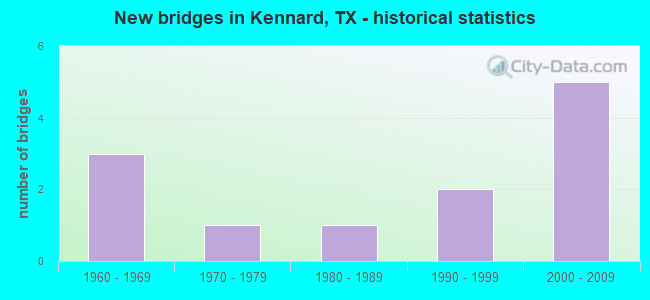
- New bridges - historical statistics
- 31960-1969
- 11970-1979
- 11980-1989
- 21990-1999
- 52000-2009


- Bridge Condition - Deck
- 10.0%Very good
- 40.0%Good
- 40.0%Satisfactory
- 10.0%Fair

- Bridge Condition - Superstructure
- 40.0%Very good
- 10.0%Good
- 30.0%Satisfactory
- 20.0%Fair

- Bridge Condition - Substructure
- 10.0%Very good
- 30.0%Good
- 20.0%Satisfactory
- 30.0%Fair
- 10.0%Poor

- Bridge Condition - Channel
- 16.7%Good
- 50.0%Satisfactory
- 33.3%Fair
Find on map >> Show street view
Structure Number: 81303000003033, Location: 1 MI N SH7 @KENNARD (Lat: 31.369747, Lng: -95.185758), Route carried "on" structure: Federal lands road 513.3, Year Built: 1966, Status: Open, Structure Length: 1.07m (3.51ft), Average Daily Traffic: 50 (year 1991), Average Future Daily Traffic: 50 (year 2011), Design Load: HS 20, Features Intersected: SOUTH COCHINO BAYOU, Facility Carried by Structure: FDR 513
Minimum Vertical Clearance: 30+ m (98+ ft), Kilometerpoint: 0.480, Lanes on structure: 1, Owner: U.S. Forest Service, Approaching Roadway Width: 5.2m (17.1ft), Material/Design: Concrete, Design/Construction: Channel Beam, Number Of Spans In Main Unit: 1, Length of Maximum Span: 10.4m (34.1ft), Curb-To-Curb Width: 5.2m (17.1ft), Out-to-Out Width: 5.5m (18.0ft)
Condition: Deck: Satisfactory, Superstructure: Satisfactory, Substructure: Fair, Channel: Fair, Operating Rating: 39.9 metric tons, Method Used To Determine Operating Rating: Load and Resistance Factor Rating (LRFR) rating reported by rating factor(RF) method using HL-93 loadings, Inventory Rating: 30.8 metric tons, Method Used To Determine Inventory Rating: Load and Resistance Factor Rating (LRFR) rating reported by rating factor(RF) method using HL-93 loadings, Structural Evaluation: Somewhat better than minimum adequacy, Deck Geometry: High priority of corrective action, Waterway Adequacy: Better than present minimum criteria, Approach Roadway Alignment: Equal to present desirable criteria, Length Of Structure Improvement: 1.12m (3.67ft), Designated Inspection Frequency: Every 24 months, Inspection Date: April 2021, Bridge Improvement Cost: $222,000,000, Total Project Cost: $222,000,000, Deck Structure Type: Concrete Precast Panels, Wearing Surface/Protective System: Wearing Surface: Other
Find on map >> Show street view
Structure Number: 81303000003034, Location: 0.9 MI NW OF SH7 (Lat: 31.393839, Lng: -95.159286), Route carried "on" structure: Federal lands road 520.9, Year Built: 1978, Status: Posted for load, Structure Length: 0.94m (3.08ft), Average Daily Traffic: 50 (year 1991), Average Future Daily Traffic: 50 (year 2011), Design Load: HS 20, Features Intersected: LEE CREEK, Facility Carried by Structure: RATCLIFF LAKE RD
Minimum Vertical Clearance: 30+ m (98+ ft), Kilometerpoint: 1.440, Lanes on structure: 2, Owner: U.S. Forest Service, Approaching Roadway Width: 7.3m (24.0ft), Material/Design: Concrete, Design/Construction: Stringer/Multi-beam, Number Of Spans In Main Unit: 1, Length of Maximum Span: 9.1m (29.9ft), Curb or Sidewalk Widths: Left: 0.3m (1.0ft), Right: 0.3m (1.0ft), Curb-To-Curb Width: 7.3m (24.0ft), Out-to-Out Width: 7.9m (25.9ft)
Condition: Deck: Good, Superstructure: Good, Substructure: Satisfactory, Channel: Satisfactory, Operating Rating: 18.5 metric tons, Method Used To Determine Operating Rating: Load and Resistance Factor Rating (LRFR) rating reported by rating factor(RF) method using HL-93 loadings, Inventory Rating: 14.3 metric tons, Method Used To Determine Inventory Rating: Load and Resistance Factor Rating (LRFR) rating reported by rating factor(RF) method using HL-93 loadings, Structural Evaluation: Meets minimum limits, Deck Geometry: Equal to present minimum criteria, Waterway Adequacy: Equal to present desirable criteria, Approach Roadway Alignment: Equal to present desirable criteria, Bridge Posting: Required (Relationship of Operating Rating to Maximum Legal Load: 0.1 - 9.9% below), Length Of Structure Improvement: 0.94m (3.08ft), Designated Inspection Frequency: Every 24 months, Inspection Date: April 2021, Bridge Improvement Cost: $93,000,000, Total Project Cost: $93,000,000, Deck Structure Type: Concrete Cast-file-Place, Wearing Surface/Protective System: Wearing Surface: Other
Find on map >> Show street view
Structure Number: 111140033601043, Location: 0.95 MI NE OF FM 357 (Lat: 31.368522, Lng: -95.171406), Route carried "on" structure: State highway 7, Year Built: 2006, Status: Open, Structure Length: 3.96m (12.99ft), Average Daily Traffic: 3,586 (year 2020), Truck Traffic: 18%, Average Future Daily Traffic: 5,220 (year 2033), Design Load: HS 20, Features Intersected: COCHINO BAYOU
Minimum Vertical Clearance: 30+ m (98+ ft), Kilometerpoint: 28.292, Lanes on structure: 2, Base Highway Network: Yes, Owner: State Highway Agency, Approaching Roadway Width: 13.4m (44.0ft), Material/Design: Prestressed concrete, Design/Construction: Stringer/Multi-beam, Number Of Spans In Main Unit: 3, Length of Maximum Span: 15.2m (49.9ft), Curb-To-Curb Width: 13.3m (43.6ft), Out-to-Out Width: 14.0m (45.9ft)
Condition: Deck: Very good, Superstructure: Very good, Substructure: Good, Channel: Fair, Operating Rating: 54.4 metric tons, Method Used To Determine Operating Rating: Assigned rating based on Load Factor Design (LFD) reported in metric tons, Inventory Rating: 32.7 metric tons, Method Used To Determine Inventory Rating: Assigned rating based on Load Factor Design (LFD) reported in metric tons, Structural Evaluation: Better than present minimum criteria, Deck Geometry: Equal to present minimum criteria, Waterway Adequacy: Superior to present desirable criteria, Approach Roadway Alignment: Equal to present desirable criteria, Designated Inspection Frequency: Every 24 months, Inspection Date: May 2020, Deck Structure Type: Concrete Precast Panels
Find on map >> Show street view
Structure Number: 111140033601044, Location: 1.1 MI NE OF FM 357 (Lat: 31.370383, Lng: -95.169053), Route carried "on" structure: State highway 7, Year Built: 2006, Status: Open, Structure Length: 1.52m (4.99ft), Average Daily Traffic: 3,586 (year 2020), Truck Traffic: 18%, Average Future Daily Traffic: 5,220 (year 2033), Design Load: HS 20, Features Intersected: E FORK OF COCHINO BAYOU
Minimum Vertical Clearance: 30+ m (98+ ft), Kilometerpoint: 28.577, Lanes on structure: 2, Base Highway Network: Yes, Owner: State Highway Agency, Approaching Roadway Width: 13.4m (44.0ft), Material/Design: Prestressed concrete, Design/Construction: Stringer/Multi-beam, Number Of Spans In Main Unit: 1, Length of Maximum Span: 15.2m (49.9ft), Curb-To-Curb Width: 13.3m (43.6ft), Out-to-Out Width: 14.0m (45.9ft)
Condition: Deck: Good, Superstructure: Very good, Substructure: Good, Channel: Satisfactory, Operating Rating: 54.4 metric tons, Method Used To Determine Operating Rating: Assigned rating based on Load Factor Design (LFD) reported in metric tons, Inventory Rating: 32.7 metric tons, Method Used To Determine Inventory Rating: Assigned rating based on Load Factor Design (LFD) reported in metric tons, Structural Evaluation: Better than present minimum criteria, Deck Geometry: Equal to present minimum criteria, Waterway Adequacy: Superior to present desirable criteria, Approach Roadway Alignment: Equal to present desirable criteria, Designated Inspection Frequency: Every 24 months, Inspection Date: May 2020, Deck Structure Type: Concrete Precast Panels
Find on map >> Show street view
Structure Number: 111140094001004, Location: 1.1 MI E OF SH 7 (Lat: 31.355778, Lng: -95.165936), Route carried "on" structure: State highway 357, Year Built: 2002, Status: Open, Structure Length: 2.44m (8.01ft), Average Daily Traffic: 356 (year 2019), Truck Traffic: 14%, Average Future Daily Traffic: 460 (year 2033), Design Load: HS 20, Features Intersected: ELM CREEK
Minimum Vertical Clearance: 30+ m (98+ ft), Kilometerpoint: 1.767, Lanes on structure: 2, Owner: State Highway Agency, Approaching Roadway Width: 7.9m (25.9ft), Material/Design: Prestressed concrete, Design/Construction: Stringer/Multi-beam, Number Of Spans In Main Unit: 1, Length of Maximum Span: 24.4m (80.1ft), Curb-To-Curb Width: 8.5m (27.9ft), Out-to-Out Width: 9.1m (29.9ft)
Condition: Deck: Good, Superstructure: Very good, Substructure: Good, Channel: Good, Operating Rating: 54.4 metric tons, Method Used To Determine Operating Rating: Assigned rating based on Load Factor Design (LFD) reported in metric tons, Inventory Rating: 32.7 metric tons, Method Used To Determine Inventory Rating: Assigned rating based on Load Factor Design (LFD) reported in metric tons, Structural Evaluation: Better than present minimum criteria, Deck Geometry: Equal to present minimum criteria, Waterway Adequacy: Superior to present desirable criteria, Approach Roadway Alignment: Equal to present desirable criteria, Designated Inspection Frequency: Every 24 months, Inspection Date: May 2020, Deck Structure Type: Concrete Precast Panels
Find on map >> Show street view
Structure Number: 111140094001005, Location: 2.1 MI E OF SH 7 (Lat: 31.348708, Lng: -95.151733), Route carried "on" structure: State highway 357, Year Built: 2005, Status: Open, Structure Length: 2.29m (7.51ft), Average Daily Traffic: 356 (year 2019), Truck Traffic: 14%, Average Future Daily Traffic: 460 (year 2033), Design Load: HS 20, Features Intersected: WALLACE CREEK
Minimum Vertical Clearance: 30+ m (98+ ft), Kilometerpoint: 3.331, Lanes on structure: 2, Owner: State Highway Agency, Approaching Roadway Width: 9.1m (29.9ft), Material/Design: Prestressed concrete, Design/Construction: Stringer/Multi-beam, Number Of Spans In Main Unit: 1, Length of Maximum Span: 22.9m (75.1ft), Curb-To-Curb Width: 9.1m (29.9ft), Out-to-Out Width: 9.8m (32.2ft)
Condition: Deck: Good, Superstructure: Very good, Substructure: Very good, Channel: Satisfactory, Operating Rating: 54.4 metric tons, Method Used To Determine Operating Rating: Assigned rating based on Load Factor Design (LFD) reported in metric tons, Inventory Rating: 32.7 metric tons, Method Used To Determine Inventory Rating: Assigned rating based on Load Factor Design (LFD) reported in metric tons, Structural Evaluation: Equal to present desirable criteria, Deck Geometry: Equal to present minimum criteria, Waterway Adequacy: Superior to present desirable criteria, Approach Roadway Alignment: Equal to present desirable criteria, Designated Inspection Frequency: Every 24 months, Inspection Date: May 2020, Deck Structure Type: Concrete Cast-file-Place
Find on map >> Show street view
Structure Number: 111140270701001, Location: 4.45 MI S OF SH 7 (Lat: 31.300292, Lng: -95.203433), Route carried "on" structure: State highway 2781, Year Built: 1965, Status: Open, Structure Length: 0.91m (2.99ft), Average Daily Traffic: 650 (year 2019), Truck Traffic: 20%, Average Future Daily Traffic: 700 (year 2033), Design Load: HS 20, Features Intersected: PINEY CREEK
Minimum Vertical Clearance: 30+ m (98+ ft), Kilometerpoint: 7.078, Lanes on structure: 2, Owner: State Highway Agency, Approaching Roadway Width: 7.3m (24.0ft), Material/Design: Concrete, Design/Construction: Culvert, Number Of Spans In Main Unit: 3, Length of Maximum Span: 2.7m (8.9ft), Curb-To-Curb Width: 7.3m (24.0ft), Out-to-Out Width: 10.5m (34.4ft)
Condition: Channel: Fair, Culverts: Satisfactory, Operating Rating: 39.9 metric tons, Method Used To Determine Operating Rating: Load Factor (LF), Inventory Rating: 23.6 metric tons, Method Used To Determine Inventory Rating: Load Factor (LF), Structural Evaluation: Equal to present minimum criteria, Deck Geometry: Meets minimum limits, Waterway Adequacy: Equal to present minimum criteria, Approach Roadway Alignment: Equal to present desirable criteria, Designated Inspection Frequency: Every 24 months, Inspection Date: May 2020, Deck Structure Type: Concrete Cast-file-Place, Wearing Surface/Protective System: Wearing Surface: Bituminous
Find on map >> Show street view
Structure Number: 111140AA0176002, Location: 1.1 MI SE OF SH7 (Lat: 31.367919, Lng: -95.147617), Route carried "on" structure: County highway 4700, Year Built: 1980, Status: Posted for load, Structure Length: 0.61m (2.00ft), Average Daily Traffic: 210 (year 2013), Average Future Daily Traffic: 155 (year 2033), Features Intersected: LEE CREEK
Minimum Vertical Clearance: 30+ m (98+ ft), Kilometerpoint: 1.851, Lanes on structure: 1, Owner: County Highway Agency, Approaching Roadway Width: 4.9m (16.1ft), Skew: 1 degrees, Material/Design: Steel, Design/Construction: Stringer/Multi-beam, Number Of Spans In Main Unit: 1, Length of Maximum Span: 5.8m (19.0ft), Curb-To-Curb Width: 4.2m (13.8ft), Out-to-Out Width: 4.2m (13.8ft)
Condition: Deck: Fair, Superstructure: Satisfactory, Substructure: Poor, Channel: Satisfactory, Operating Rating: 31.7 metric tons, Method Used To Determine Operating Rating: Allowable Stress (AS), Inventory Rating: 22.7 metric tons, Method Used To Determine Inventory Rating: Allowable Stress (AS), Structural Evaluation: Meets minimum limits, Deck Geometry: High priority of replacement, Waterway Adequacy: Meets minimum limits, Approach Roadway Alignment: Equal to present minimum criteria, Bridge Posting: Required (Relationship of Operating Rating to Maximum Legal Load: 20.0 - 29.9% below), Length Of Structure Improvement: 0.64m (2.10ft), Designated Inspection Frequency: Every 24 months, Inspection Date: June 2021, Bridge Improvement Cost: $1,000, Total Project Cost: $1,000, Deck Structure Type: Wood or Timber, Wearing Surface/Protective System: Wearing Surface: Wood or Timber
Find on map >> Show street view
Structure Number: 111140AA0182001, Location: 1.4 MI SW SH7 @ RATCLIFF (Lat: 31.373461, Lng: -95.149739), Route carried "on" structure: County highway 4710, Year Built: 1998, Status: Posted for load, Structure Length: 0.94m (3.08ft), Average Daily Traffic: 55 (year 2013), Average Future Daily Traffic: 60 (year 2033), Features Intersected: LEE CREEK
Minimum Vertical Clearance: 30+ m (98+ ft), Kilometerpoint: 1.609, Lanes on structure: 1, Owner: County Highway Agency, Approaching Roadway Width: 4.9m (16.1ft), Material/Design: Steel, Design/Construction: Stringer/Multi-beam, Number Of Spans In Main Unit: 1, Length of Maximum Span: 9.1m (29.9ft), Curb-To-Curb Width: 4.5m (14.8ft), Out-to-Out Width: 4.9m (16.1ft)
Condition: Deck: Satisfactory, Superstructure: Satisfactory, Substructure: Satisfactory, Channel: Good, Operating Rating: 24.5 metric tons, Method Used To Determine Operating Rating: Allowable Stress (AS), Inventory Rating: 16.3 metric tons, Method Used To Determine Inventory Rating: Allowable Stress (AS), Structural Evaluation: Somewhat better than minimum adequacy, Deck Geometry: Equal to present minimum criteria, Waterway Adequacy: Meets minimum limits, Approach Roadway Alignment: Equal to present desirable criteria, Bridge Posting: Required (Relationship of Operating Rating to Maximum Legal Load: > 39.9% below), Designated Inspection Frequency: Every 24 months, Inspection Date: June 2021, Deck Structure Type: Wood or Timber, Wearing Surface/Protective System: Wearing Surface: Wood or Timber
Find on map >> Show street view
Structure Number: 111140AA0194001, Location: 0.7 MI S OF SH7 @ KENNARD (Lat: 31.348878, Lng: -95.183119), Route carried "on" structure: County highway 4625, Year Built: 1960, Status: Open, Structure Length: 0.67m (2.20ft), Average Daily Traffic: 239 (year 2018), Average Future Daily Traffic: 450 (year 2033), Features Intersected: ELM CREEK
Minimum Vertical Clearance: 30+ m (98+ ft), Kilometerpoint: 11.748, Lanes on structure: 1, Owner: County Highway Agency, Approaching Roadway Width: 4.3m (14.1ft), Material/Design: Concrete, Design/Construction: Culvert, Number Of Spans In Main Unit: 2, Length of Maximum Span: 3.0m (9.8ft), Curb-To-Curb Width: 4.9m (16.1ft), Out-to-Out Width: 5.3m (17.4ft)
Condition: Channel: Fair, Culverts: Satisfactory, Operating Rating: 32.7 metric tons, Method Used To Determine Operating Rating: Field evaluation and documented engineering judgment, Inventory Rating: 24.5 metric tons, Method Used To Determine Inventory Rating: Field evaluation and documented engineering judgment, Structural Evaluation: Equal to present minimum criteria, Deck Geometry: High priority of replacement, Waterway Adequacy: Better than present minimum criteria, Approach Roadway Alignment: Equal to present desirable criteria, Length Of Structure Improvement: 0.67m (2.20ft), Designated Inspection Frequency: Every 24 months, Inspection Date: June 2021, Bridge Improvement Cost: $1,000, Total Project Cost: $1,000, Deck Structure Type: Concrete Cast-file-Place, Wearing Surface/Protective System: Wearing Surface: Bituminous
Find on map >> Show street view
Structure Number: 111140AA0194002, Location: 1.8 MI NW OF SH7 @ KENNAR (Lat: 31.376728, Lng: -95.199289), Route carried "on" structure: County highway 1095, Year Built: 2000, Status: Posted for load, Structure Length: 0.61m (2.00ft), Average Daily Traffic: 55 (year 2013), Average Future Daily Traffic: 60 (year 2033), Features Intersected: SOUTH FORK COCHINO BAYOU
Minimum Vertical Clearance: 30+ m (98+ ft), Kilometerpoint: 15.772, Lanes on structure: 1, Owner: County Highway Agency, Approaching Roadway Width: 4.9m (16.1ft), Material/Design: Steel, Design/Construction: Stringer/Multi-beam, Number Of Spans In Main Unit: 1, Length of Maximum Span: 5.8m (19.0ft), Curb-To-Curb Width: 4.5m (14.8ft), Out-to-Out Width: 4.9m (16.1ft)
Condition: Deck: Satisfactory, Superstructure: Fair, Substructure: Fair, Channel: Satisfactory, Operating Rating: 46.3 metric tons, Method Used To Determine Operating Rating: Allowable Stress (AS), Inventory Rating: 32.7 metric tons, Method Used To Determine Inventory Rating: Allowable Stress (AS), Structural Evaluation: Somewhat better than minimum adequacy, Deck Geometry: Equal to present minimum criteria, Waterway Adequacy: High priority of corrective action, Approach Roadway Alignment: Equal to present minimum criteria, Bridge Posting: Required (Relationship of Operating Rating to Maximum Legal Load: 0.1 - 9.9% below), Designated Inspection Frequency: Every 24 months, Inspection Date: June 2021, Deck Structure Type: Wood or Timber, Wearing Surface/Protective System: Wearing Surface: Wood or Timber
Find on map >> Show street view
Structure Number: 111140AA0196002, Location: 0.3 MI E OF JCT FM 2781 (Lat: 31.295650, Lng: -95.199478), Route carried "on" structure: County highway 4615, Year Built: 1991, Status: Posted for load, Structure Length: 1.86m (6.10ft), Average Daily Traffic: 55 (year 2015), Average Future Daily Traffic: 60 (year 2035), Features Intersected: PINEY CREEK
Minimum Vertical Clearance: 30+ m (98+ ft), Kilometerpoint: 9.656, Lanes on structure: 1, Owner: County Highway Agency, Approaching Roadway Width: 4.9m (16.1ft), Material/Design: Steel continuous, Design/Construction: Stringer/Multi-beam, Number Of Spans In Main Unit: 2, Length of Maximum Span: 9.1m (29.9ft), Curb-To-Curb Width: 4.9m (16.1ft), Out-to-Out Width: 4.9m (16.1ft)
Condition: Deck: Satisfactory, Superstructure: Fair, Substructure: Fair, Channel: Satisfactory, Operating Rating: 36.3 metric tons, Method Used To Determine Operating Rating: Allowable Stress (AS), Inventory Rating: 25.4 metric tons, Method Used To Determine Inventory Rating: Allowable Stress (AS), Structural Evaluation: Somewhat better than minimum adequacy, Deck Geometry: High priority of corrective action, Waterway Adequacy: Somewhat better than minimum adequacy, Approach Roadway Alignment: Better than present minimum criteria, Bridge Posting: Required (Relationship of Operating Rating to Maximum Legal Load: 20.0 - 29.9% below), Length Of Structure Improvement: 1.86m (6.10ft), Designated Inspection Frequency: Every 24 months, Inspection Date: June 2021, Deck Structure Type: Wood or Timber, Wearing Surface/Protective System: Wearing Surface: Wood or Timber