Bridge Statistics for Huber Ridge, Ohio (OH)
Condition, Traffic, Stress, Structural Evaluation, Project Costs
- National Bridge Inventory (NBI) Statistics
- 16Number of bridges
- 184ft / 55.9mTotal length
- 1,081,016Total average daily traffic
- 95,076Total average daily truck traffic
- National Bridge Inventory (NBI) Registered Bridges for Huber Ridge
- No street view available for this location
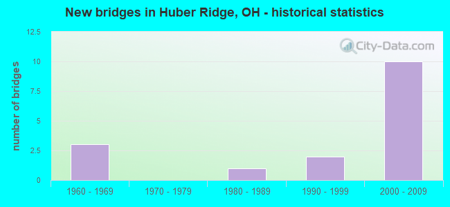
- New bridges - historical statistics
- 31960-1969
- 11980-1989
- 21990-1999
- 102000-2009


- Bridge Condition - Deck
- 57.1%Very good
- 28.6%Good
- 14.3%Satisfactory

- Bridge Condition - Superstructure
- 14.3%Excellent
- 42.9%Very good
- 42.9%Good

- Bridge Condition - Substructure
- 42.9%Very good
- 42.9%Good
- 14.3%Satisfactory

- Bridge Condition - Channel
- 50.0%Good
- 50.0%Satisfactory
Find on map >> Show street view
Structure Number: 2500256, Location: 7.82 MI N. OF 71 (Lat: 40.091400, Lng: -82.925600), Route carried "on" structure: State highway 3, Year Built: 1983, Status: Open, Structure Length: 4.50m (14.76ft), Average Daily Traffic: 17,046 (year 2015), Truck Traffic: 5%, Average Future Daily Traffic: 23,660 (year 2035), Design Load: HS 20+Mod, Features Intersected: ALUM CREEK
Minimum Vertical Clearance: 30+ m (98+ ft), Kilometerpoint: 40.684, Lanes on structure: 4, Base Highway Network: Yes, Owner: State Highway Agency, Approaching Roadway Width: 15.9m (52.2ft), Skew: 1 degrees, Material/Design: Prestressed concrete, Design/Construction: Box Beam or Girders - Multiple, Number Of Spans In Main Unit: 3, Length of Maximum Span: 14.6m (47.9ft), Curb-To-Curb Width: 15.9m (52.2ft), Out-to-Out Width: 15.9m (52.2ft)
Condition: Deck: Very good, Superstructure: Very good, Substructure: Good, Channel: Good, Operating Rating: 55.1 metric tons, Method Used To Determine Operating Rating: Load and Resistance Factor Rating (LRFR) rating reported by rating factor(RF) method using HL-93 loadings, Inventory Rating: 42.1 metric tons, Method Used To Determine Inventory Rating: Load and Resistance Factor Rating (LRFR) rating reported by rating factor(RF) method using HL-93 loadings, Structural Evaluation: Better than present minimum criteria, Deck Geometry: Meets minimum limits, Waterway Adequacy: Equal to present desirable criteria, Approach Roadway Alignment: Equal to present minimum criteria, Designated Inspection Frequency: Every 24 months, Inspection Date: January 2021, Deck Structure Type: Concrete Cast-file-Place, Wearing Surface/Protective System: Wearing Surface: Bituminous, Membrane: Built-up
Find on map >> Show street view
Structure Number: 2509059, Location: OVER I-270 (Lat: 40.082350, Lng: -82.907731), Route carried "on" structure: State highway 161, Year Built: 2007, Status: Open, Structure Length: 10.39m (34.09ft), Average Daily Traffic: 21,340 (year 2015), Truck Traffic: 3%, Average Future Daily Traffic: 29,620 (year 2035), Design Load: HS 25 or greater, Features Intersected: OVER I-270
Minimum Vertical Clearance: 30+ m (98+ ft), Kilometerpoint: 25.267, Lanes on structure: 5, Lanes under structure: 9, Base Highway Network: Yes, Owner: State Highway Agency, Approaching Roadway Width: 28.3m (92.8ft), Skew: 30 degrees, Material/Design: Steel continuous, Design/Construction: Stringer/Multi-beam, Number Of Spans In Main Unit: 2, Length of Maximum Span: 52.7m (172.9ft), Curb-To-Curb Width: 33.4m (109.6ft), Out-to-Out Width: 34.4m (112.9ft)
Condition: Deck: Very good, Superstructure: Excellent, Substructure: Very good, Operating Rating: 42.1 metric tons, Method Used To Determine Operating Rating: Load Factor (LF) rating reported by rating factor (RF) method using MS18 loading, Inventory Rating: 32.4 metric tons, Method Used To Determine Inventory Rating: Load Factor (LF) rating reported by rating factor (RF) method using MS18 loading, Structural Evaluation: Equal to present desirable criteria, Deck Geometry: Superior to present desirable criteria, Underclear: Meets minimum limits, Approach Roadway Alignment: Equal to present desirable criteria, Designated Inspection Frequency: Every 24 months, Inspection Date: July 2020, Deck Structure Type: Concrete Cast-file-Place, Wearing Surface/Protective System: Wearing Surface: Monolithic Concrete, Deck Protection: Epoxy Coated Reinforcing
Find on map >> Show street view
Structure Number: 2509113, Location: 161/270 NE SIDE (Lat: 40.082411, Lng: -82.908700), Route carried "on" structure: Ramp Interstate 270, Year Built: 2005, Status: Open, Structure Length: 8.51m (27.92ft), Average Daily Traffic: 132,501 (year 2010), Truck Traffic: 9%, Average Future Daily Traffic: 183,911 (year 2030), Design Load: HS 25 or greater, Features Intersected: RAMP F OVER 161/RAMP B, Facility Carried by Structure: RAMP F
Minimum Vertical Clearance: 30+ m (98+ ft), Kilometerpoint: 49.069, Lanes on structure: 2, Lanes under structure: 5, Owner: State Highway Agency, Approaching Roadway Width: 12.2m (40.0ft), Material/Design: Steel continuous, Design/Construction: Stringer/Multi-beam, Number Of Spans In Main Unit: 3, Length of Maximum Span: 30.4m (99.7ft), Curb-To-Curb Width: 12.6m (41.3ft), Out-to-Out Width: 13.5m (44.3ft)
Condition: Deck: Very good, Superstructure: Very good, Substructure: Very good, Operating Rating: 77.8 metric tons, Method Used To Determine Operating Rating: Load Factor (LF) rating reported by rating factor (RF) method using MS18 loading, Inventory Rating: 48.6 metric tons, Method Used To Determine Inventory Rating: Load Factor (LF) rating reported by rating factor (RF) method using MS18 loading, Structural Evaluation: Equal to present desirable criteria, Deck Geometry: Superior to present desirable criteria, Underclear: Equal to present minimum criteria, Approach Roadway Alignment: Somewhat better than minimum adequacy, Designated Inspection Frequency: Every 24 months, Inspection Date: June 2021, Deck Structure Type: Concrete Cast-file-Place, Wearing Surface/Protective System: Wearing Surface: Monolithic Concrete, Deck Protection: Epoxy Coated Reinforcing
Find on map >> Show street view
Structure Number: 2511797, Location: 6.45 MI N OF US62 (Lat: 40.100631, Lng: -82.925419), Route carried "on" structure: Ramp Interstate 270, Year Built: 1968, Status: Open, Structure Length: 6.40m (21.00ft), Average Daily Traffic: 62,830 (year 1990), Average Future Daily Traffic: 87,208 (year 2010), Design Load: HS 20+Mod, Features Intersected: RT CD ROAD OVER SR 3
Minimum Vertical Clearance: 30+ m (98+ ft), Kilometerpoint: 46.204, Lanes on structure: 1, Lanes under structure: 4, Owner: State Highway Agency, Approaching Roadway Width: 12.2m (40.0ft), Skew: 1 degrees, Material/Design: Steel continuous, Design/Construction: Stringer/Multi-beam, Number Of Spans In Main Unit: 4, Length of Maximum Span: 19.2m (63.0ft), Curb-To-Curb Width: 10.4m (34.1ft), Out-to-Out Width: 11.6m (38.1ft)
Condition: Deck: Good, Superstructure: Good, Substructure: Satisfactory, Operating Rating: 42.1 metric tons, Method Used To Determine Operating Rating: Load Factor (LF) rating reported by rating factor (RF) method using MS18 loading, Inventory Rating: 32.4 metric tons, Method Used To Determine Inventory Rating: Load Factor (LF) rating reported by rating factor (RF) method using MS18 loading, Structural Evaluation: Equal to present minimum criteria, Deck Geometry: Superior to present desirable criteria, Underclear: Somewhat better than minimum adequacy, Approach Roadway Alignment: Equal to present minimum criteria, Designated Inspection Frequency: Every 24 months, Inspection Date: November 2021, Deck Structure Type: Concrete Cast-file-Place, Wearing Surface/Protective System: Wearing Surface: Integral Concrete
Find on map >> Show street view
Structure Number: 2511878, Location: 6.45 MI N OF US 62 (Lat: 40.100819, Lng: -82.925400), Route carried "on" structure: Interstate 270, Year Built: 1999, Status: Open, Structure Length: 5.89m (19.32ft), Average Daily Traffic: 133,464 (year 2015), Truck Traffic: 13%, Average Future Daily Traffic: 185,248 (year 2035), Design Load: HS 20+Mod, Features Intersected: OVER ST RT 3
Minimum Vertical Clearance: 30+ m (98+ ft), Kilometerpoint: 46.204, Lanes on structure: 8, Lanes under structure: 4, Base Highway Network: Yes, Owner: State Highway Agency, Approaching Roadway Width: 22.5m (73.8ft), Skew: 1 degrees, Material/Design: Steel continuous, Design/Construction: Stringer/Multi-beam, Number Of Spans In Main Unit: 4, Length of Maximum Span: 18.1m (59.4ft), Curb-To-Curb Width: 43.4m (142.4ft), Out-to-Out Width: 45.2m (148.3ft)
Condition: Deck: Satisfactory, Superstructure: Good, Substructure: Good, Operating Rating: 94.0 metric tons, Method Used To Determine Operating Rating: Load Factor (LF) rating reported by rating factor (RF) method using MS18 loading, Inventory Rating: 58.3 metric tons, Method Used To Determine Inventory Rating: Load Factor (LF) rating reported by rating factor (RF) method using MS18 loading, Structural Evaluation: Better than present minimum criteria, Deck Geometry: Superior to present desirable criteria, Underclear: High priority of corrective action, Approach Roadway Alignment: Better than present minimum criteria, Designated Inspection Frequency: Every 24 months, Inspection Date: November 2021, Deck Structure Type: Concrete Cast-file-Place, Wearing Surface/Protective System: Wearing Surface: Monolithic Concrete, Deck Protection: Epoxy Coated Reinforcing
Find on map >> Show street view
Structure Number: 2512351, Location: 161/270 NE SIDE (Lat: 40.083131, Lng: -82.907069), Route carried "on" structure: Ramp Interstate 270, Year Built: 2006, Status: Open, Structure Length: 17.24m (56.56ft), Average Daily Traffic: 132,501 (year 2010), Truck Traffic: 9%, Average Future Daily Traffic: 183,911 (year 2030), Design Load: HS 25 or greater, Features Intersected: RIR270NB-SR161WBOIR270&R
Minimum Vertical Clearance: 30+ m (98+ ft), Kilometerpoint: 49.037, Lanes on structure: 1, Lanes under structure: 8, Owner: State Highway Agency, Approaching Roadway Width: 8.5m (27.9ft), Skew: 1 degrees, Material/Design: Prestressed concrete continuous, Design/Construction: Stringer/Multi-beam, Number Of Spans In Main Unit: 5, Length of Maximum Span: 35.6m (116.8ft), Curb-To-Curb Width: 9.0m (29.5ft), Out-to-Out Width: 9.9m (32.5ft)
Condition: Deck: Very good, Superstructure: Very good, Substructure: Very good, Operating Rating: 48.6 metric tons, Method Used To Determine Operating Rating: Load Factor (LF) rating reported by rating factor (RF) method using MS18 loading, Inventory Rating: 25.9 metric tons, Method Used To Determine Inventory Rating: Load Factor (LF) rating reported by rating factor (RF) method using MS18 loading, Structural Evaluation: Equal to present minimum criteria, Deck Geometry: Superior to present desirable criteria, Underclear: High priority of corrective action, Approach Roadway Alignment: Somewhat better than minimum adequacy, Designated Inspection Frequency: Every 24 months, Inspection Date: June 2021, Deck Structure Type: Concrete Cast-file-Place, Wearing Surface/Protective System: Wearing Surface: Monolithic Concrete, Deck Protection: Epoxy Coated Reinforcing
Find on map >> Show street view
Structure Number: 2512378, Location: AT SR-161 (Lat: 40.082750, Lng: -82.906600), Route carried "on" structure: Interstate 270, Year Built: 2007, Status: Open, Structure Length: 2.28m (7.48ft), Average Daily Traffic: 181,641 (year 2017), Truck Traffic: 9%, Average Future Daily Traffic: 252,118 (year 2037), Features Intersected: OVER RAMP (161WB-270SB)
Minimum Vertical Clearance: 5.51m (18.08ft), Kilometerpoint: 49.133, Lanes on structure: 9, Lanes under structure: 2, Base Highway Network: Yes, Owner: State Highway Agency, Approaching Roadway Width: 15.0m (49.2ft), Skew: 4 degrees, Material/Design: Concrete, Design/Construction: Slab, Number Of Spans In Main Unit: 1, Length of Maximum Span: 15.9m (52.2ft), Curb-To-Curb Width: 62.5m (205.1ft), Out-to-Out Width: 99.0m (324.8ft)
Condition: Deck: Good, Superstructure: Good, Substructure: Good, Operating Rating: 42.1 metric tons, Method Used To Determine Operating Rating: Load Factor (LF) rating reported by rating factor (RF) method using MS18 loading, Inventory Rating: 32.4 metric tons, Method Used To Determine Inventory Rating: Load Factor (LF) rating reported by rating factor (RF) method using MS18 loading, Structural Evaluation: Better than present minimum criteria, Deck Geometry: Superior to present desirable criteria, Underclear: Equal to present minimum criteria, Approach Roadway Alignment: Equal to present desirable criteria, Designated Inspection Frequency: Every 24 months, Inspection Date: June 2021, Deck Structure Type: Concrete Cast-file-Place, Wearing Surface/Protective System: Wearing Surface: Bituminous, Membrane: Preformed Fabric, Deck Protection: Epoxy Coated Reinforcing
Find on map >> Show street view
Structure Number: 2531542, Location: 0.2 MI NORTH OF S.R. 161 (Lat: 40.083369, Lng: -82.916861), Route carried "on" structure: County highway T2092, Year Built: 1962, Status: Open, Structure Length: 0.73m (2.40ft), Average Daily Traffic: 5,922 (year 2015), Truck Traffic: 5%, Average Future Daily Traffic: 8,220 (year 2035), Features Intersected: SPRING RUN(BUENOS AIRES), Facility Carried by Structure: BUENOS AIRES BLVD
Minimum Vertical Clearance: 30+ m (98+ ft), Kilometerpoint: 0.032, Lanes on structure: 2, Owner: County Highway Agency, Approaching Roadway Width: 10.4m (34.1ft), Skew: 2 degrees, Material/Design: Steel, Design/Construction: Culvert, Number Of Spans In Main Unit: 1, Length of Maximum Span: 7.3m (24.0ft)
Condition: Channel: Satisfactory, Culverts: Good, Operating Rating: 97.2 metric tons, Method Used To Determine Operating Rating: Allowable Stress (AS) rating reported by rating factor (RF) method using MS18 loading, Inventory Rating: 68.0 metric tons, Method Used To Determine Inventory Rating: Allowable Stress (AS) rating reported by rating factor (RF) method using MS18 loading, Structural Evaluation: Better than present minimum criteria, Waterway Adequacy: Equal to present desirable criteria, Approach Roadway Alignment: Equal to present minimum criteria, Designated Inspection Frequency: Every 24 months, Inspection Date: November 2021
Find on map >> Show street view
Structure Number: 2509059, Location: OVER I-270 (Lat: 40.082350, Lng: -82.907731), Route carried "under" structure: Interstate 270, Year Built: 2007, Structure Length: 0. m, Average Daily Traffic: 154,140 (year 2015), Truck Traffic: 13%, Features Intersected: UNDER SR-161 WB, Facility Carried by Structure: SR-161
Minimum Vertical Clearance: 5.56m (18.24ft), Kilometerpoint: 49.117, Lanes on structure: 5, Lanes under structure: 9, Material/Design: Steel continuous, Design/Construction: Stringer/Multi-beam, Length of Maximum Span: 52.7m (172.9ft)
Find on map >> Show street view
Structure Number: 2509113, Location: 161/270 NE SIDE (Lat: 40.082411, Lng: -82.908700), Route carried "under" structure: State highway 161, Year Built: 2005, Structure Length: 0. m, Average Daily Traffic: 21,340 (year 2015), Truck Traffic: 3%, Features Intersected: UNDER RAMP 270SB TO 161E, Facility Carried by Structure: RAMP F
Minimum Vertical Clearance: 5.26m (17.26ft), Kilometerpoint: 25.186, Lanes on structure: 2, Lanes under structure: 5, Material/Design: Steel continuous, Design/Construction: Stringer/Multi-beam, Length of Maximum Span: 30.4m (99.7ft)
Find on map >> Show street view
Structure Number: 2509113, Location: 161/270 NE SIDE (Lat: 40.082411, Lng: -82.908700), Route carried "under" structure: Ramp State highway RAMPB, Year Built: 2005, Structure Length: 0. m, Features Intersected: UNDER RAMP 270SB TO 161E, Facility Carried by Structure: RAMP F
Minimum Vertical Clearance: 5.11m (16.77ft), Kilometerpoint: 0.000, Lanes on structure: 2, Lanes under structure: 5, Material/Design: Steel continuous, Design/Construction: Stringer/Multi-beam, Length of Maximum Span: 30.4m (99.7ft)
Find on map >> Show street view
Structure Number: 2511797, Location: 6.45 MI N OF US62 (Lat: 40.100631, Lng: -82.925419), Route carried "under" structure: State highway 3, Year Built: 1968, Structure Length: 0. m, Average Daily Traffic: 32,683 (year 2015), Truck Traffic: 5%, Features Intersected: CD ROAD FROM 270EB, Facility Carried by Structure: I270 C-D ROAD
Minimum Vertical Clearance: 4.55m (14.93ft), Kilometerpoint: 41.698, Lanes on structure: 1, Lanes under structure: 4, Material/Design: Steel continuous, Design/Construction: Stringer/Multi-beam, Length of Maximum Span: 19.2m (63.0ft)
Find on map >> Show street view
Structure Number: 2511878, Location: 6.45 MI N OF US 62 (Lat: 40.100819, Lng: -82.925400), Route carried "under" structure: State highway 3, Year Built: 1999, Structure Length: 0. m, Average Daily Traffic: 32,683 (year 2015), Truck Traffic: 5%, Features Intersected: I270, Facility Carried by Structure: I270
Minimum Vertical Clearance: 4.55m (14.93ft), Kilometerpoint: 41.714, Lanes on structure: 8, Lanes under structure: 4, Material/Design: Steel continuous, Design/Construction: Stringer/Multi-beam, Length of Maximum Span: 18.1m (59.4ft)
Find on map >> Show street view
Structure Number: 2512351, Location: 161/270 NE SIDE (Lat: 40.083131, Lng: -82.907069), Route carried "under" structure: Interstate 270, Year Built: 2006, Structure Length: 0. m, Average Daily Traffic: 38,591 (year 2015), Truck Traffic: 18%, Features Intersected: UNDER RAMP 270NB-161WB
Minimum Vertical Clearance: 7.26m (23.82ft), Kilometerpoint: 49.037, Lanes on structure: 1, Lanes under structure: 8, Material/Design: Prestressed concrete continuous, Design/Construction: Stringer/Multi-beam, Length of Maximum Span: 35.6m (116.8ft)
Find on map >> Show street view
Structure Number: 2512351, Location: 161/270 NE SIDE (Lat: 40.083131, Lng: -82.907069), Route carried "under" structure: Ramp State highway 161, Year Built: 2006, Structure Length: 0. m, Average Daily Traffic: 86,598 (year 2010), Truck Traffic: 4%, Features Intersected: UNDER RAMP 270NB-161WB
Minimum Vertical Clearance: 15.29m (50.16ft), Kilometerpoint: 25.315, Lanes on structure: 1, Lanes under structure: 8, Material/Design: Prestressed concrete continuous, Design/Construction: Stringer/Multi-beam, Length of Maximum Span: 35.6m (116.8ft)
Find on map >> Show street view
Structure Number: 2512378, Location: AT SR-161 (Lat: 40.082750, Lng: -82.906600), Route carried "under" structure: Ramp Interstate 270, Year Built: 2007, Structure Length: 0. m, Average Daily Traffic: 27,736 (year 2017), Truck Traffic: 5%, Features Intersected: IR-270
Minimum Vertical Clearance: 5.03m (16.50ft), Kilometerpoint: 49.133, Lanes on structure: 9, Lanes under structure: 2, Material/Design: Concrete, Design/Construction: Slab, Length of Maximum Span: 15.9m (52.2ft)