Bridge Statistics for Hooverson Heights, West Virginia (WV)
Condition, Traffic, Stress, Structural Evaluation, Project Costs
- National Bridge Inventory (NBI) Statistics
- 12Number of bridges
- 89ft / 27.2mTotal length
- $3,869,000Total costs
- 8,950Total average daily traffic
- 267Total average daily truck traffic
- National Bridge Inventory (NBI) Registered Bridges for Hooverson Heights
- No street view available for this location
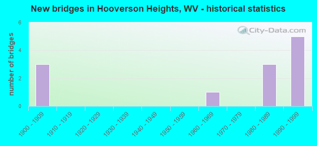
- New bridges - historical statistics
- 31900-1909
- 11960-1969
- 31980-1989
- 51990-1999

- Bridge Condition - Deck
- 62.5%Good
- 12.5%Satisfactory
- 25.0%Fair

- Bridge Condition - Superstructure
- 75.0%Good
- 12.5%Satisfactory
- 12.5%Fair

- Bridge Condition - Substructure
- 37.5%Good
- 50.0%Fair
- 12.5%Poor

- Bridge Condition - Channel
- 11.1%Good
- 11.1%Satisfactory
- 55.6%Fair
- 22.2%Poor
Find on map >> Show street view
Structure Number: 5A016, Location: 0.28 mi. East jct WV 2 (Lat: 40.306261, Lng: -80.594811), Route carried "on" structure: County highway 7, Year Built: 1960, Year Reconstructed: 1988, Status: Open, Structure Length: 3.87m (12.70ft), Average Daily Traffic: 3,000 (year 2019), Truck Traffic: 3%, Average Future Daily Traffic: 4,470 (year 2039), Design Load: HS 25 or greater, Features Intersected: Cross Creek
Minimum Vertical Clearance: 30+ m (98+ ft), Kilometerpoint: 0.451, Lanes on structure: 2, Owner: State Highway Agency, Approaching Roadway Width: 9.8m (32.2ft), Material/Design: Prestressed concrete, Design/Construction: Box Beam or Girders - Multiple, Number Of Spans In Main Unit: 1, Number Of Approach Spans: 2, Length of Maximum Span: 15.0m (49.2ft), Curb-To-Curb Width: 8.0m (26.2ft), Out-to-Out Width: 8.3m (27.2ft)
Condition: Deck: Good, Superstructure: Good, Substructure: Poor, Channel: Poor, Operating Rating: 79.8 metric tons, Method Used To Determine Operating Rating: Load Factor (LF), Inventory Rating: 48.1 metric tons, Method Used To Determine Inventory Rating: Load Factor (LF), Structural Evaluation: Meets minimum limits, Deck Geometry: High priority of corrective action, Waterway Adequacy: Superior to present desirable criteria, Approach Roadway Alignment: Equal to present minimum criteria, Length Of Structure Improvement: 4.63m (15.19ft), Designated Inspection Frequency: Every 24 months, Underwater Inspection Frequency: Every 60 months, Inspection Date: July 2020, Underwater Inspection Date: August 2020, Bridge Improvement Cost: $506,000, Roadway Improvement Cost: $486,000, Total Project Cost: $992,000 ( Estimate for 2018), Deck Structure Type: Other, Wearing Surface/Protective System: Wearing Surface: Bituminous
Find on map >> Show street view
Structure Number: 5A02, Location: 0.01 mi. West jct CR 7/2 (Lat: 40.309969, Lng: -80.571781), Route carried "on" structure: County highway 7, Year Built: 1989, Status: Open, Structure Length: 0.96m (3.15ft), Average Daily Traffic: 900 (year 2020), Truck Traffic: 3%, Average Future Daily Traffic: 1,341 (year 2040), Design Load: HS 20, Features Intersected: Bosley Run
Minimum Vertical Clearance: 30+ m (98+ ft), Kilometerpoint: 3.219, Lanes on structure: 2, Owner: State Highway Agency, Approaching Roadway Width: 7.0m (23.0ft), Material/Design: Prestressed concrete, Design/Construction: Box Beam or Girders - Multiple, Number Of Spans In Main Unit: 1, Length of Maximum Span: 9.1m (29.9ft), Curb-To-Curb Width: 6.6m (21.7ft), Out-to-Out Width: 7.4m (24.3ft)
Condition: Deck: Satisfactory, Superstructure: Satisfactory, Substructure: Fair, Channel: Fair, Operating Rating: 84.4 metric tons, Method Used To Determine Operating Rating: Load Factor (LF), Inventory Rating: 50.8 metric tons, Method Used To Determine Inventory Rating: Load Factor (LF), Structural Evaluation: Somewhat better than minimum adequacy, Deck Geometry: High priority of corrective action, Waterway Adequacy: Equal to present minimum criteria, Approach Roadway Alignment: Meets minimum limits, Length Of Structure Improvement: 1.65m (5.41ft), Designated Inspection Frequency: Every 24 months, Other Special Inspection Frequency: Every 12 months, Inspection Date: April 2021, Other Special Inspection Date: April 2021, Bridge Improvement Cost: $170,000, Roadway Improvement Cost: $168,000, Total Project Cost: $338,000 ( Estimate for 2019), Deck Structure Type: Other, Wearing Surface/Protective System: Wearing Surface: Bituminous, Deck Protection: Epoxy Coated Reinforcing
Find on map >> Show street view
Structure Number: 5A021, Location: 0.18 mi. East jct CR 14 (Lat: 40.305781, Lng: -80.561761), Route carried "on" structure: County highway 7, Year Built: 1995, Status: Open, Structure Length: 1.68m (5.51ft), Average Daily Traffic: 450 (year 2020), Truck Traffic: 3%, Average Future Daily Traffic: 671 (year 2040), Design Load: HS 25 or greater, Features Intersected: Ebenezer Run
Minimum Vertical Clearance: 30+ m (98+ ft), Kilometerpoint: 4.281, Lanes on structure: 2, Owner: State Highway Agency, Approaching Roadway Width: 4.9m (16.1ft), Skew: 5 degrees, Material/Design: Concrete, Design/Construction: Culvert, Number Of Spans In Main Unit: 2, Length of Maximum Span: 7.1m (23.3ft), Out-to-Out Width: 8.2m (26.9ft)
Condition: Channel: Satisfactory, Culverts: Good, Operating Rating: 88.9 metric tons, Method Used To Determine Operating Rating: Field evaluation and documented engineering judgment, Inventory Rating: 40.8 metric tons, Method Used To Determine Inventory Rating: Field evaluation and documented engineering judgment, Structural Evaluation: Better than present minimum criteria, Waterway Adequacy: Somewhat better than minimum adequacy, Approach Roadway Alignment: Equal to present minimum criteria, Length Of Structure Improvement: 2.93m (9.61ft), Designated Inspection Frequency: Every 24 months, Inspection Date: April 2021, Bridge Improvement Cost: $263,000, Roadway Improvement Cost: $15,000, Total Project Cost: $350,000 ( Estimate for 2019)
Find on map >> Show street view
Structure Number: 5A022, Location: 0.01 mi. East jct CR7/4 (Lat: 40.299850, Lng: -80.532231), Route carried "on" structure: County highway 7, Year Built: 1989, Status: Open, Structure Length: 1.08m (3.54ft), Average Daily Traffic: 150 (year 2020), Truck Traffic: 3%, Average Future Daily Traffic: 224 (year 2040), Design Load: HS 25 or greater, Features Intersected: Scott Run
Minimum Vertical Clearance: 30+ m (98+ ft), Kilometerpoint: 7.435, Lanes on structure: 1, Owner: State Highway Agency, Approaching Roadway Width: 6.4m (21.0ft), Material/Design: Prestressed concrete, Design/Construction: Box Beam or Girders - Multiple, Number Of Spans In Main Unit: 1, Length of Maximum Span: 9.3m (30.5ft), Curb-To-Curb Width: 4.6m (15.1ft), Out-to-Out Width: 4.6m (15.1ft)
Condition: Deck: Good, Superstructure: Good, Substructure: Fair, Channel: Good, Operating Rating: 88.9 metric tons, Method Used To Determine Operating Rating: Load Factor (LF), Inventory Rating: 60.8 metric tons, Method Used To Determine Inventory Rating: Load Factor (LF), Structural Evaluation: Somewhat better than minimum adequacy, Deck Geometry: High priority of replacement, Waterway Adequacy: Better than present minimum criteria, Approach Roadway Alignment: Somewhat better than minimum adequacy, Length Of Structure Improvement: 1.86m (6.10ft), Designated Inspection Frequency: Every 24 months, Inspection Date: July 2021, Bridge Improvement Cost: $129,000, Roadway Improvement Cost: $128,000, Total Project Cost: $257,000 ( Estimate for 2019), Deck Structure Type: Other, Wearing Surface/Protective System: Wearing Surface: Bituminous, Deck Protection: Epoxy Coated Reinforcing
Find on map >> Show street view
Structure Number: 5A023, Location: 0.04 mi. South jct CR 7 (Lat: 40.306000, Lng: -80.565650), Route carried "on" structure: County highway 76, Year Built: 1986, Status: Open, Structure Length: 3.78m (12.40ft), Average Daily Traffic: 100 (year 2019), Truck Traffic: 3%, Average Future Daily Traffic: 149 (year 2039), Design Load: HS 20, Features Intersected: Cross Creek, Facility Carried by Structure: County Route 7/6
Minimum Vertical Clearance: 30+ m (98+ ft), Kilometerpoint: 0.064, Lanes on structure: 2, Owner: State Highway Agency, Approaching Roadway Width: 7.6m (24.9ft), Material/Design: Steel continuous, Design/Construction: Stringer/Multi-beam, Number Of Spans In Main Unit: 2, Length of Maximum Span: 18.3m (60.0ft), Curb or Sidewalk Widths: Left: 0.2m (0.7ft), Right: 0.2m (0.7ft), Curb-To-Curb Width: 7.3m (24.0ft), Out-to-Out Width: 8.4m (27.6ft)
Condition: Deck: Good, Superstructure: Good, Substructure: Fair, Channel: Fair, Operating Rating: 87.1 metric tons, Method Used To Determine Operating Rating: Load Factor (LF), Inventory Rating: 52.6 metric tons, Method Used To Determine Inventory Rating: Load Factor (LF), Structural Evaluation: Somewhat better than minimum adequacy, Deck Geometry: Equal to present minimum criteria, Waterway Adequacy: Equal to present minimum criteria, Approach Roadway Alignment: Equal to present minimum criteria, Length Of Structure Improvement: 3.78m (12.40ft), Designated Inspection Frequency: Every 24 months, Inspection Date: October 2020, Bridge Improvement Cost: $89,000, Total Project Cost: $89,000 ( Estimate for 2020), Deck Structure Type: Concrete Cast-file-Place, Wearing Surface/Protective System: Wearing Surface: Monolithic Concrete, Deck Protection: Epoxy Coated Reinforcing
Find on map >> Show street view
Structure Number: 5A033, Location: 0.02 mi. South jct CR 7 (Lat: 40.302181, Lng: -80.545161), Route carried "on" structure: County highway 275, Year Built: 1996, Status: Open, Structure Length: 3.69m (12.11ft), Average Daily Traffic: 300 (year 2019), Truck Traffic: 3%, Average Future Daily Traffic: 447 (year 2039), Design Load: HS 25 or greater, Features Intersected: Cross Creek, Facility Carried by Structure: County Route 27/5
Minimum Vertical Clearance: 30+ m (98+ ft), Kilometerpoint: 3.235, Lanes on structure: 2, Owner: State Highway Agency, Approaching Roadway Width: 8.2m (26.9ft), Material/Design: Prestressed concrete, Design/Construction: Box Beam or Girders - Multiple, Number Of Spans In Main Unit: 2, Length of Maximum Span: 17.7m (58.1ft), Curb-To-Curb Width: 7.9m (25.9ft), Out-to-Out Width: 8.4m (27.6ft)
Condition: Deck: Good, Superstructure: Good, Substructure: Good, Channel: Poor, Operating Rating: 88.9 metric tons, Method Used To Determine Operating Rating: Load Factor (LF), Inventory Rating: 61.7 metric tons, Method Used To Determine Inventory Rating: Load Factor (LF), Structural Evaluation: Better than present minimum criteria, Deck Geometry: Somewhat better than minimum adequacy, Waterway Adequacy: Equal to present desirable criteria, Approach Roadway Alignment: High priority of corrective action, Length Of Structure Improvement: 3.72m (12.20ft), Designated Inspection Frequency: Every 24 months, Inspection Date: June 2020, Bridge Improvement Cost: $436,000, Roadway Improvement Cost: $427,000, Total Project Cost: $900,000 ( Estimate for 2020), Deck Structure Type: Other, Wearing Surface/Protective System: Wearing Surface: Bituminous, Deck Protection: Epoxy Coated Reinforcing
Find on map >> Show street view
Structure Number: 5A076, Location: 0.20 mi. West jct CR7/1 (Lat: 40.305450, Lng: -80.577250), Route carried "on" structure: County highway 7, Year Built: 1998, Status: Open, Structure Length: 5.04m (16.54ft), Average Daily Traffic: 950 (year 2019), Truck Traffic: 3%, Average Future Daily Traffic: 1,416 (year 2039), Design Load: HS 25 or greater, Features Intersected: Cross Creek
Minimum Vertical Clearance: 30+ m (98+ ft), Kilometerpoint: 2.076, Lanes on structure: 2, Owner: State Highway Agency, Approaching Roadway Width: 10.7m (35.1ft), Material/Design: Steel continuous, Design/Construction: Stringer/Multi-beam, Number Of Spans In Main Unit: 1, Number Of Approach Spans: 2, Length of Maximum Span: 21.0m (68.9ft), Curb-To-Curb Width: 9.8m (32.2ft), Out-to-Out Width: 10.6m (34.8ft)
Condition: Deck: Good, Superstructure: Good, Substructure: Good, Channel: Fair, Operating Rating: 88.9 metric tons, Method Used To Determine Operating Rating: Load Factor (LF), Inventory Rating: 56.2 metric tons, Method Used To Determine Inventory Rating: Load Factor (LF), Structural Evaluation: Better than present minimum criteria, Deck Geometry: Equal to present minimum criteria, Waterway Adequacy: Equal to present minimum criteria, Approach Roadway Alignment: Meets minimum limits, Length Of Structure Improvement: 4.91m (16.11ft), Designated Inspection Frequency: Every 24 months, Inspection Date: September 2020, Bridge Improvement Cost: $183,000, Roadway Improvement Cost: $100,000, Total Project Cost: $300,000 ( Estimate for 2020), Deck Structure Type: Concrete Cast-file-Place, Wearing Surface/Protective System: Wearing Surface: Monolithic Concrete, Deck Protection: Epoxy Coated Reinforcing
Find on map >> Show street view
Structure Number: 5A077, Location: 0.03 mi. West jct CR18/1 (Lat: 40.304400, Lng: -80.580789), Route carried "on" structure: County highway 7, Year Built: 1998, Status: Open, Structure Length: 4.34m (14.24ft), Average Daily Traffic: 3,000 (year 2019), Truck Traffic: 3%, Average Future Daily Traffic: 4,470 (year 2039), Design Load: HS 25 or greater, Features Intersected: Cross Creek
Minimum Vertical Clearance: 30+ m (98+ ft), Kilometerpoint: 1.706, Lanes on structure: 2, Owner: State Highway Agency, Approaching Roadway Width: 10.7m (35.1ft), Skew: 9 degrees, Material/Design: Steel continuous, Design/Construction: Box Beam or Girders - Multiple, Number Of Spans In Main Unit: 1, Number Of Approach Spans: 1, Length of Maximum Span: 22.8m (74.8ft), Curb-To-Curb Width: 9.6m (31.5ft), Out-to-Out Width: 10.6m (34.8ft)
Condition: Deck: Fair, Superstructure: Good, Substructure: Fair, Channel: Fair, Operating Rating: 88.9 metric tons, Method Used To Determine Operating Rating: Load Factor (LF), Inventory Rating: 88.9 metric tons, Method Used To Determine Inventory Rating: Load Factor (LF), Structural Evaluation: Somewhat better than minimum adequacy, Deck Geometry: Meets minimum limits, Waterway Adequacy: Superior to present desirable criteria, Approach Roadway Alignment: Somewhat better than minimum adequacy, Length Of Structure Improvement: 4.36m (14.30ft), Designated Inspection Frequency: Every 24 months, Inspection Date: August 2020, Bridge Improvement Cost: $136,000, Roadway Improvement Cost: $50,000, Total Project Cost: $186,000 ( Estimate for 2020), Deck Structure Type: Concrete Cast-file-Place, Wearing Surface/Protective System: Wearing Surface: Monolithic Concrete, Deck Protection: Epoxy Coated Reinforcing
Find on map >> Show street view
Structure Number: 5A08, Location: 0.20 mi. South jct CR 7 (Lat: 40.302139, Lng: -80.584139), Route carried "on" structure: Other road 953, Year Built: 1991, Status: Posted for load, Structure Length: 2.73m (8.96ft), Average Daily Traffic: 100 (year 2019), Truck Traffic: 3%, Average Future Daily Traffic: 149 (year 2039), Features Intersected: Cross Creek
Minimum Vertical Clearance: 30+ m (98+ ft), Kilometerpoint: 0.322, Lanes on structure: 1, Owner: State Highway Agency, Approaching Roadway Width: 4.9m (16.1ft), Material/Design: Steel continuous, Design/Construction: Stringer/Multi-beam, Number Of Spans In Main Unit: 2, Length of Maximum Span: 13.3m (43.6ft), Curb-To-Curb Width: 4.8m (15.7ft), Out-to-Out Width: 4.9m (16.1ft)
Condition: Deck: Fair, Superstructure: Fair, Substructure: Good, Channel: Fair, Operating Rating: 25.4 metric tons, Method Used To Determine Operating Rating: Load Factor (LF), Inventory Rating: 15.4 metric tons, Method Used To Determine Inventory Rating: Load Factor (LF), Structural Evaluation: Meets minimum limits, Deck Geometry: Equal to present desirable criteria, Waterway Adequacy: Meets minimum limits, Approach Roadway Alignment: Meets minimum limits, Bridge Posting: Required (Relationship of Operating Rating to Maximum Legal Load: 0.1 - 9.9% below), Length Of Structure Improvement: 3.05m (10.01ft), Designated Inspection Frequency: Every 24 months, Other Special Inspection Frequency: Every 12 months, Inspection Date: July 2021, Other Special Inspection Date: July 2021, Bridge Improvement Cost: $211,000, Roadway Improvement Cost: $206,000, Total Project Cost: $457,000 ( Estimate for 2016), Deck Structure Type: Wood or Timber, Wearing Surface/Protective System: Wearing Surface: Wood or Timber
Find on map >> Show street view
Structure Number: 5A01, Location: 0.23 mi. North jct CR 7 (Lat: 40.310389, Lng: -80.601669), Route carried "under" structure: State highway 2, Year Built: 1902, Structure Length: 0. m, Features Intersected: West Virginia Route 2, Facility Carried by Structure: Whg & Lake Erie RR
Minimum Vertical Clearance: 10.06m (33.01ft), Kilometerpoint: 16.464, Lanes under structure: 2, Length of Maximum Span: 12.2m (40.0ft)
Find on map >> Show street view
Structure Number: 5A018, Location: 0.01 mi. East jct CR18/1 (Lat: 40.304800, Lng: -80.580561), Route carried "under" structure: County highway 7, Year Built: 1902, Structure Length: 0. m, Features Intersected: County Rt. 7 & Cross Crk, Facility Carried by Structure: Whg & Lake Erie RR
Minimum Vertical Clearance: 8.84m (29.00ft), Kilometerpoint: 1.770, Lanes under structure: 2, Length of Maximum Span: 9.9m (32.5ft)
Find on map >> Show street view
Structure Number: 5A031, Location: 0.04 mi. South jct CR 7 (Lat: 40.301819, Lng: -80.546200), Route carried "under" structure: County highway 275, Year Built: 1902, Structure Length: 0. m, Features Intersected: County Route 27/5, Facility Carried by Structure: Whg & Lake Erie RR
Minimum Vertical Clearance: 3.81m (12.50ft), Kilometerpoint: 3.187, Lanes under structure: 2, Length of Maximum Span: 11.4m (37.4ft)