Bridge Statistics for Highlands-Baywood Park, California (CA)
Condition, Traffic, Stress, Structural Evaluation, Project Costs
- National Bridge Inventory (NBI) Statistics
- 19Number of bridges
- 499ft / 152mTotal length
- $231,000Total costs
- 977,542Total average daily traffic
- 28,002Total average daily truck traffic
- National Bridge Inventory (NBI) Registered Bridges for Highlands-Baywood Park
- No street view available for this location
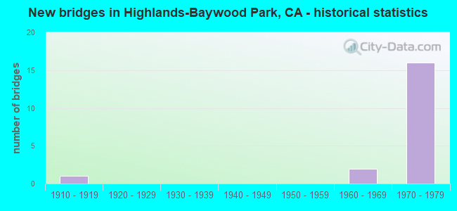
- New bridges - historical statistics
- 11910-1919
- 21960-1969
- 161970-1979


- Bridge Condition - Deck
- 60.0%Good
- 40.0%Fair

- Bridge Condition - Superstructure
- 16.7%Good
- 66.7%Fair
- 16.7%Poor

- Bridge Condition - Substructure
- 83.3%Good
- 16.7%Poor

- Bridge Condition - Channel
- 50.0%Good
- 50.0%Serious
Find on map >> Show street view
Structure Number: 35 0199, Location: 04-SM-280-R12.73 (Lat: 37.528344, Lng: -122.359478), Route carried "on" structure: Interstate 280, Year Built: 1967, Status: Open, Structure Length: 50.15m (164.53ft), Average Daily Traffic: 106,000 (year 2009), Truck Traffic: 3%, Average Future Daily Traffic: 339,637 (year 2038), Design Load: HS 20+Mod, Features Intersected: SAN MATEO CR,CRYSTAL SPR
Minimum Vertical Clearance: 30+ m (98+ ft), Kilometerpoint: 12.730, Lanes on structure: 8, Base Highway Network: Yes (Inventory Route: 2, Subroute: 1), Owner: State Highway Agency, Approaching Roadway Width: 20.7m (67.9ft), Skew: 30 degrees, Material/Design: Steel continuous, Design/Construction: Stringer/Multi-beam, Number Of Spans In Main Unit: 5, Length of Maximum Span: 109.8m (360.2ft), Curb-To-Curb Width: 41.5m (136.2ft), Out-to-Out Width: 43.2m (141.7ft)
Condition: Deck: Good, Superstructure: Fair, Substructure: Good, Channel: Good, Operating Rating: 55.7 metric tons, Method Used To Determine Operating Rating: Load Factor (LF), Inventory Rating: 33.4 metric tons, Method Used To Determine Inventory Rating: Load Factor (LF), Structural Evaluation: Somewhat better than minimum adequacy, Deck Geometry: Superior to present desirable criteria, Waterway Adequacy: Equal to present desirable criteria, Approach Roadway Alignment: Equal to present desirable criteria, Designated Inspection Frequency: Every 24 months, Other Special Inspection Frequency: Every 48 months, Inspection Date: July 2021, Other Special Inspection Date: September 2018, Deck Structure Type: Concrete Cast-file-Place
Find on map >> Show street view
Structure Number: 35 0243L, Location: 04-SM-280-10.81 (Lat: 37.506603, Lng: -122.338106), Route carried "on" structure: Interstate 280, Year Built: 1973, Status: Open, Structure Length: 10.01m (32.84ft), Average Daily Traffic: 53,500 (year 1998), Truck Traffic: 3%, Average Future Daily Traffic: 80,137 (year 2038), Design Load: HS 20, Features Intersected: STATE ROUTE 92
Minimum Vertical Clearance: 30+ m (98+ ft), Kilometerpoint: 10.810, Lanes on structure: 4, Lanes under structure: 5, Base Highway Network: Yes (Inventory Route: 2, Subroute: 1), Owner: State Highway Agency, Approaching Roadway Width: 20.1m (65.9ft), Skew: 4 degrees, Material/Design: Prestressed concrete continuous, Design/Construction: Box Beam or Girders - Multiple, Number Of Spans In Main Unit: 2, Length of Maximum Span: 55.0m (180.4ft), Curb-To-Curb Width: 20.1m (65.9ft), Out-to-Out Width: 21.2m (69.6ft)
Condition: Deck: Good, Superstructure: Good, Substructure: Good, Operating Rating: 92.7 metric tons, Method Used To Determine Operating Rating: Load Factor (LF), Inventory Rating: 32.4 metric tons, Method Used To Determine Inventory Rating: Load Factor (LF), Structural Evaluation: Better than present minimum criteria, Deck Geometry: Equal to present minimum criteria, Underclear: Somewhat better than minimum adequacy, Approach Roadway Alignment: Equal to present desirable criteria, Designated Inspection Frequency: Every 24 months, Inspection Date: October 2021, Deck Structure Type: Concrete Cast-file-Place
Find on map >> Show street view
Structure Number: 35 0243R, Location: 04-SM-280-10.81 (Lat: 37.506856, Lng: -122.337789), Route carried "on" structure: Interstate 280, Year Built: 1973, Status: Open, Structure Length: 9.80m (32.15ft), Average Daily Traffic: 52,000 (year 2009), Truck Traffic: 3%, Average Future Daily Traffic: 80,137 (year 2038), Design Load: HS 20, Features Intersected: STATE ROUTE 92
Minimum Vertical Clearance: 30+ m (98+ ft), Kilometerpoint: 10.810, Lanes on structure: 5, Lanes under structure: 5, Base Highway Network: Yes (Inventory Route: 2, Subroute: 1), Owner: State Highway Agency, Approaching Roadway Width: 23.8m (78.1ft), Skew: 4 degrees, Material/Design: Prestressed concrete continuous, Design/Construction: Box Beam or Girders - Multiple, Number Of Spans In Main Unit: 2, Length of Maximum Span: 55.4m (181.8ft), Curb-To-Curb Width: 23.8m (78.1ft), Out-to-Out Width: 24.9m (81.7ft)
Condition: Deck: Good, Superstructure: Fair, Substructure: Good, Operating Rating: 72.9 metric tons, Method Used To Determine Operating Rating: Load Factor (LF), Inventory Rating: 32.4 metric tons, Method Used To Determine Inventory Rating: Load Factor (LF), Structural Evaluation: Somewhat better than minimum adequacy, Deck Geometry: Equal to present minimum criteria, Underclear: Somewhat better than minimum adequacy, Approach Roadway Alignment: Equal to present desirable criteria, Designated Inspection Frequency: Every 24 months, Inspection Date: October 2021, Deck Structure Type: Concrete Cast-file-Place
Find on map >> Show street view
Structure Number: 35 0244G, Location: 04-SM-280-10.91 (Lat: 37.506347, Lng: -122.336367), Route carried "on" structure: Ramp Interstate 280, Year Built: 1974, Status: Open, Structure Length: 43.78m (143.64ft), Average Daily Traffic: 3,700 (year 2003), Truck Traffic: 2%, Average Future Daily Traffic: 11,757 (year 2038), Design Load: HS 20+Mod, Features Intersected: INTERSTATE 280, SR 92
Minimum Vertical Clearance: 30+ m (98+ ft), Kilometerpoint: 10.910, Lanes on structure: 1, Lanes under structure: 20, Base Highway Network: Yes (Inventory Route: 2, Subroute: 1), Owner: State Highway Agency, Approaching Roadway Width: 12.5m (41.0ft), Skew: 2 degrees, Material/Design: Prestressed concrete continuous, Design/Construction: Box Beam or Girders - Multiple, Number Of Spans In Main Unit: 6, Number Of Approach Spans: 4, Length of Maximum Span: 57.1m (187.3ft), Curb-To-Curb Width: 12.2m (40.0ft), Out-to-Out Width: 13.3m (43.6ft)
Condition: Deck: Fair, Superstructure: Fair, Substructure: Good, Operating Rating: 90.4 metric tons, Method Used To Determine Operating Rating: Load Factor (LF), Inventory Rating: 32.4 metric tons, Method Used To Determine Inventory Rating: Load Factor (LF), Structural Evaluation: Somewhat better than minimum adequacy, Deck Geometry: Superior to present desirable criteria, Underclear: Superior to present desirable criteria, Approach Roadway Alignment: Equal to present minimum criteria, Designated Inspection Frequency: Every 24 months, Inspection Date: October 2021, Deck Structure Type: Concrete Cast-file-Place
Find on map >> Show street view
Structure Number: 35 0245F, Location: 04-SM-280-10.80 (Lat: 37.507153, Lng: -122.336158), Route carried "on" structure: Ramp Interstate 280, Year Built: 1973, Status: Open, Structure Length: 37.96m (124.54ft), Average Daily Traffic: 14,500 (year 1998), Truck Traffic: 2%, Average Future Daily Traffic: 26,721 (year 2038), Design Load: HS 20+Mod, Features Intersected: INTERSTATE 280, SR 92
Minimum Vertical Clearance: 5.33m (17.49ft), Kilometerpoint: 10.800, Lanes on structure: 2, Lanes under structure: 14, Base Highway Network: Yes (Inventory Route: 2, Subroute: 1), Owner: State Highway Agency, Approaching Roadway Width: 12.2m (40.0ft), Skew: 2 degrees, Material/Design: Prestressed concrete continuous, Design/Construction: Box Beam or Girders - Multiple, Number Of Spans In Main Unit: 3, Number Of Approach Spans: 5, Length of Maximum Span: 59.2m (194.2ft), Curb-To-Curb Width: 12.2m (40.0ft), Out-to-Out Width: 13.3m (43.6ft)
Condition: Deck: Fair, Superstructure: Fair, Substructure: Good, Operating Rating: 99.8 metric tons, Method Used To Determine Operating Rating: Load Factor (LF), Inventory Rating: 32.4 metric tons, Method Used To Determine Inventory Rating: Load Factor (LF), Structural Evaluation: Somewhat better than minimum adequacy, Deck Geometry: Superior to present desirable criteria, Underclear: Somewhat better than minimum adequacy, Approach Roadway Alignment: Equal to present minimum criteria, Designated Inspection Frequency: Every 24 months, Inspection Date: October 2021, Deck Structure Type: Concrete Cast-file-Place
Find on map >> Show street view
Structure Number: 35C0111, Location: 0.46 MI N OF S.H. 92 (Lat: 37.498589, Lng: -122.384992), Route carried "on" structure: County highway , Year Built: 1910, Status: Open, Structure Length: 0.79m (2.59ft), Average Daily Traffic: 42 (year 2017), Truck Traffic: 22%, Average Future Daily Traffic: 100 (year 2040), Design Load: H 10, Features Intersected: PILARCITOS CREEK, Facility Carried by Structure: PILARCITOS CREEK R
Minimum Vertical Clearance: 30+ m (98+ ft), Kilometerpoint: 0.000, Lanes on structure: 2, Owner: County Highway Agency, Approaching Roadway Width: 5.2m (17.1ft), Material/Design: Concrete, Design/Construction: Arch - Deck, Number Of Spans In Main Unit: 1, Length of Maximum Span: 6.1m (20.0ft), Curb-To-Curb Width: 7.6m (24.9ft), Out-to-Out Width: 8.2m (26.9ft)
Condition: Superstructure: Poor, Substructure: Poor, Channel: Serious, Operating Rating: 27.2 metric tons, Method Used To Determine Operating Rating: Field evaluation and documented engineering judgment, Inventory Rating: 16.2 metric tons, Method Used To Determine Inventory Rating: Field evaluation and documented engineering judgment, Structural Evaluation: Meets minimum limits, Deck Geometry: Equal to present minimum criteria, Waterway Adequacy: Equal to present minimum criteria, Approach Roadway Alignment: Equal to present minimum criteria, Length Of Structure Improvement: 0.79m (2.59ft), Designated Inspection Frequency: Every 24 months, Inspection Date: May 2021, Bridge Improvement Cost: $60,000, Roadway Improvement Cost: $27,000, Total Project Cost: $231,000 ( Estimate for 2017)
Find on map >> Show street view
Structure Number: 35 004, Location: 04-SM-280-R12.32 (Lat: 37.523061, Lng: -122.356419), Route carried "under" structure: Interstate 280, Year Built: 1969, Structure Length: 0. m, Average Daily Traffic: 111,000 (year 1998), Truck Traffic: 2%, Features Intersected: INTERSTATE 280, Facility Carried by Structure: BUNKER HILL DRIVE
Minimum Vertical Clearance: 5.11m (16.77ft), Kilometerpoint: 12.320, Lanes on structure: 2, Lanes under structure: 8, Material/Design: Prestressed concrete continuous, Design/Construction: Box Beam or Girders - Multiple, Length of Maximum Span: 39.6m (129.9ft)
Find on map >> Show street view
Structure Number: 35 0243L, Location: 04-SM-280-10.81 (Lat: 37.506603, Lng: -122.338106), Route carried "under" structure: State highway 92, Year Built: 1973, Structure Length: 0. m, Average Daily Traffic: 22,200 (year 2009), Features Intersected: STATE ROUTE 92, Facility Carried by Structure: INTERSTATE 280 SB
Minimum Vertical Clearance: 7.32m (24.02ft), Kilometerpoint: 7.300, Lanes on structure: 4, Lanes under structure: 5, Material/Design: Prestressed concrete continuous, Design/Construction: Box Beam or Girders - Multiple, Length of Maximum Span: 55.0m (180.4ft)
Find on map >> Show street view
Structure Number: 35 0243R, Location: 04-SM-280-10.81 (Lat: 37.506856, Lng: -122.337789), Route carried "under" structure: State highway 92, Year Built: 1973, Structure Length: 0. m, Average Daily Traffic: 72,000 (year 2009), Truck Traffic: 5%, Features Intersected: STATE ROUTE 92, Facility Carried by Structure: INTERSTATE 280 NB
Minimum Vertical Clearance: 5.28m (17.32ft), Kilometerpoint: 7.320, Lanes on structure: 5, Lanes under structure: 5, Material/Design: Prestressed concrete continuous, Design/Construction: Box Beam or Girders - Multiple, Length of Maximum Span: 55.4m (181.8ft)
Find on map >> Show street view
Structure Number: 35 0244G, Location: 04-SM-280-10.91 (Lat: 37.506347, Lng: -122.336367), Route carried "under" structure: Ramp Interstate 92, Year Built: 1974, Structure Length: 0. m, Average Daily Traffic: 14,500 (year 2003), Truck Traffic: 3%, Features Intersected: INTERSTATE 280, SR 92
Minimum Vertical Clearance: 7.62m (25.00ft), Kilometerpoint: 10.910, Lanes on structure: 1, Lanes under structure: 1, Material/Design: Prestressed concrete continuous, Design/Construction: Box Beam or Girders - Multiple, Length of Maximum Span: 57.1m (187.3ft)
Find on map >> Show street view
Structure Number: 35 0244G, Location: 04-SM-280-10.91 (Lat: 37.506347, Lng: -122.336367), Route carried "under" structure: Ramp Interstate 280, Year Built: 1974, Structure Length: 0. m, Average Daily Traffic: 14,500 (year 2003), Truck Traffic: 3%, Features Intersected: INTERSTATE 280, SR 92
Minimum Vertical Clearance: 5.89m (19.32ft), Kilometerpoint: 10.800, Lanes on structure: 1, Lanes under structure: 2, Material/Design: Prestressed concrete continuous, Design/Construction: Box Beam or Girders - Multiple, Length of Maximum Span: 57.1m (187.3ft)
Find on map >> Show street view
Structure Number: 35 0244G, Location: 04-SM-280-10.91 (Lat: 37.506347, Lng: -122.336367), Route carried "under" structure: Ramp Interstate 280, Year Built: 1974, Structure Length: 0. m, Average Daily Traffic: 14,500 (year 2003), Truck Traffic: 3%, Features Intersected: INTERSTATE 280, SR 92
Minimum Vertical Clearance: 5.92m (19.42ft), Kilometerpoint: 10.910, Lanes on structure: 1, Lanes under structure: 2, Material/Design: Prestressed concrete continuous, Design/Construction: Box Beam or Girders - Multiple, Length of Maximum Span: 57.1m (187.3ft)
Find on map >> Show street view
Structure Number: 35 0244G, Location: 04-SM-280-10.91 (Lat: 37.506347, Lng: -122.336367), Route carried "under" structure: State highway 92, Year Built: 1974, Structure Length: 0. m, Average Daily Traffic: 82,000 (year 2003), Truck Traffic: 5%, Features Intersected: INTERSTATE 280, SR 92
Minimum Vertical Clearance: 7.62m (25.00ft), Kilometerpoint: 7.360, Lanes on structure: 1, Lanes under structure: 7, Material/Design: Prestressed concrete continuous, Design/Construction: Box Beam or Girders - Multiple, Length of Maximum Span: 57.1m (187.3ft)
Find on map >> Show street view
Structure Number: 35 0244G, Location: 04-SM-280-10.91 (Lat: 37.506347, Lng: -122.336367), Route carried "under" structure: Interstate 280, Year Built: 1974, Structure Length: 0. m, Average Daily Traffic: 111,000 (year 2003), Truck Traffic: 2%, Features Intersected: INTERSTATE 280, SR 92
Minimum Vertical Clearance: 7.62m (25.00ft), Kilometerpoint: 10.910, Lanes on structure: 1, Lanes under structure: 8, Material/Design: Prestressed concrete continuous, Design/Construction: Box Beam or Girders - Multiple, Length of Maximum Span: 57.1m (187.3ft)
Find on map >> Show street view
Structure Number: 35 0245F, Location: 04-SM-280-10.80 (Lat: 37.507153, Lng: -122.336158), Route carried "under" structure: State highway 92, Year Built: 1973, Structure Length: 0. m, Average Daily Traffic: 23,400 (year 1998), Truck Traffic: 2%, Features Intersected: INTERSTATE 280, SR 92
Minimum Vertical Clearance: 7.62m (25.00ft), Kilometerpoint: 7.280, Lanes on structure: 2, Lanes under structure: 4, Material/Design: Prestressed concrete continuous, Design/Construction: Box Beam or Girders - Multiple, Length of Maximum Span: 59.2m (194.2ft)
Find on map >> Show street view
Structure Number: 35 0245F, Location: 04-SM-280-10.80 (Lat: 37.507153, Lng: -122.336158), Route carried "under" structure: Interstate 280, Year Built: 1973, Structure Length: 0. m, Average Daily Traffic: 111,000 (year 1998), Truck Traffic: 2%, Features Intersected: INTERSTATE 280, SR 92
Minimum Vertical Clearance: 5.34m (17.52ft), Kilometerpoint: 10.800, Lanes on structure: 2, Lanes under structure: 9, Material/Design: Prestressed concrete continuous, Design/Construction: Box Beam or Girders - Multiple, Length of Maximum Span: 59.2m (194.2ft)
Find on map >> Show street view
Structure Number: 35 0245F, Location: 04-SM-280-10.80 (Lat: 37.507153, Lng: -122.336158), Route carried "under" structure: State highway 92, Year Built: 1973, Structure Length: 0. m, Average Daily Traffic: 11,700 (year 1997), Truck Traffic: 3%, Features Intersected: INTERSTATE 280, SR 92
Minimum Vertical Clearance: 5.45m (17.88ft), Kilometerpoint: 7.300, Lanes on structure: 2, Lanes under structure: 1, Material/Design: Prestressed concrete continuous, Design/Construction: Box Beam or Girders - Multiple, Length of Maximum Span: 59.2m (194.2ft)
Find on map >> Show street view
Structure Number: 35 0285, Location: 04-SM-280-10.56 (Lat: 37.504344, Lng: -122.335033), Route carried "under" structure: Ramp Interstate 280, Year Built: 1973, Structure Length: 0. m, Average Daily Traffic: 51,000 (year 2009), Truck Traffic: 3%, Features Intersected: INTERSTATE 280, Facility Carried by Structure: CRYSTAL SP BIKE OC
Minimum Vertical Clearance: 5.64m (18.50ft), Kilometerpoint: 10.560, Lanes under structure: 2, Material/Design: Prestressed concrete continuous, Design/Construction: Box Beam or Girders - Multiple, Length of Maximum Span: 39.6m (129.9ft)
Find on map >> Show street view
Structure Number: 35 0285, Location: 04-SM-280-10.56 (Lat: 37.504344, Lng: -122.335033), Route carried "under" structure: Interstate 280, Year Built: 1973, Structure Length: 0. m, Average Daily Traffic: 109,000 (year 2001), Truck Traffic: 3%, Features Intersected: INTERSTATE 280, Facility Carried by Structure: CRYSTAL SP BIKE OC
Minimum Vertical Clearance: 5.64m (18.50ft), Kilometerpoint: 10.560, Lanes under structure: 8, Material/Design: Prestressed concrete continuous, Design/Construction: Box Beam or Girders - Multiple, Length of Maximum Span: 39.6m (129.9ft)