Bridge Statistics for Hawley, Texas (TX)
Condition, Traffic, Stress, Structural Evaluation, Project Costs
- National Bridge Inventory (NBI) Statistics
- 15Number of bridges
- 171ft / 52.2mTotal length
- 57,273Total average daily traffic
- 8,520Total average daily truck traffic
- National Bridge Inventory (NBI) Registered Bridges for Hawley
- No street view available for this location
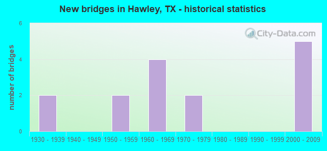
- New bridges - historical statistics
- 21930-1939
- 21950-1959
- 41960-1969
- 21970-1979
- 52000-2009

- Reconstructed bridges - Historical Statistics
- 21970-1979
- 01980-1989
- 21990-1999


- Bridge Condition - Deck
- 12.5%Very good
- 62.5%Good
- 25.0%Satisfactory

- Bridge Condition - Superstructure
- 25.0%Very good
- 75.0%Good

- Bridge Condition - Substructure
- 50.0%Good
- 25.0%Satisfactory
- 25.0%Fair

- Bridge Condition - Channel
- 72.7%Good
- 27.3%Satisfactory

- Bridge Condition - Culverts
- 60.0%Good
- 40.0%Satisfactory
Find on map >> Show street view
Structure Number: 81280003305016, Location: 3.00 MI NW OF FM 3034 (Lat: 32.557394, Lng: -99.783647), Route carried "on" structure: US 83, Year Built: 1931, Year Reconstructed: 1990, Status: Open, Structure Length: 0.82m (2.69ft), Average Daily Traffic: 11,780 (year 2020), Truck Traffic: 14%, Average Future Daily Traffic: 13,420 (year 2033), Design Load: H 15, Features Intersected: MULBERRY CREEK TRIBUTARY
Minimum Vertical Clearance: 30+ m (98+ ft), Kilometerpoint: 59.008, Lanes on structure: 6, Owner: State Highway Agency, Approaching Roadway Width: 29.9m (98.1ft), Skew: 20 degrees, Material/Design: Concrete, Design/Construction: Culvert, Number Of Spans In Main Unit: 3, Length of Maximum Span: 2.4m (7.9ft)
Condition: Channel: Good, Culverts: Satisfactory, Operating Rating: 39.9 metric tons, Method Used To Determine Operating Rating: Load Factor (LF), Inventory Rating: 23.6 metric tons, Method Used To Determine Inventory Rating: Load Factor (LF), Structural Evaluation: Somewhat better than minimum adequacy, Waterway Adequacy: Equal to present minimum criteria, Approach Roadway Alignment: Equal to present desirable criteria, Designated Inspection Frequency: Every 24 months, Inspection Date: June 2021
Find on map >> Show street view
Structure Number: 8128000330503, Location: 3.90 MI NW OF FM 3034 (Lat: 32.567500, Lng: -99.793211), Route carried "on" structure: US 83, Year Built: 1956, Year Reconstructed: 1984, Status: Open, Structure Length: 5.55m (18.21ft), Average Daily Traffic: 5,499 (year 2020), Truck Traffic: 13%, Average Future Daily Traffic: 7,060 (year 2033), Design Load: HS 20, Features Intersected: MULBERRY CREEK
Minimum Vertical Clearance: 30+ m (98+ ft), Kilometerpoint: 57.539, Lanes on structure: 2, Owner: State Highway Agency, Approaching Roadway Width: 11.6m (38.1ft), Material/Design: Concrete, Design/Construction: Stringer/Multi-beam, Number Of Spans In Main Unit: 6, Length of Maximum Span: 9.1m (29.9ft), Curb-To-Curb Width: 11.5m (37.7ft), Out-to-Out Width: 12.3m (40.4ft)
Condition: Deck: Satisfactory, Superstructure: Good, Substructure: Satisfactory, Channel: Satisfactory, Operating Rating: 68.0 metric tons, Method Used To Determine Operating Rating: Load Factor (LF), Inventory Rating: 40.8 metric tons, Method Used To Determine Inventory Rating: Load Factor (LF), Structural Evaluation: Equal to present minimum criteria, Deck Geometry: Equal to present minimum criteria, Waterway Adequacy: Superior to present desirable criteria, Approach Roadway Alignment: Equal to present desirable criteria, Designated Inspection Frequency: Every 24 months, Inspection Date: June 2021, Deck Structure Type: Concrete Cast-file-Place, Wearing Surface/Protective System: Wearing Surface: Bituminous
Find on map >> Show street view
Structure Number: 81280003305031, Location: 0.80 MI SE OF FM 1082 (Lat: 32.598425, Lng: -99.814603), Route carried "on" structure: US 83, Year Built: 1956, Year Reconstructed: 1981, Status: Open, Structure Length: 7.68m (25.20ft), Average Daily Traffic: 3,975 (year 2019), Truck Traffic: 13%, Average Future Daily Traffic: 4,340 (year 2033), Design Load: HS 20, Features Intersected: CLEAR FORK BRAZOS RIVER
Minimum Vertical Clearance: 30+ m (98+ ft), Kilometerpoint: 53.533, Lanes on structure: 2, Owner: State Highway Agency, Approaching Roadway Width: 11.6m (38.1ft), Material/Design: Steel continuous, Design/Construction: Stringer/Multi-beam, Number Of Spans In Main Unit: 3, Number Of Approach Spans: 2, Length of Maximum Span: 15.5m (50.9ft), Curb-To-Curb Width: 11.5m (37.7ft), Out-to-Out Width: 12.2m (40.0ft)
Condition: Deck: Good, Superstructure: Good, Substructure: Fair, Channel: Good, Operating Rating: 56.2 metric tons, Method Used To Determine Operating Rating: Load Factor (LF), Inventory Rating: 33.6 metric tons, Method Used To Determine Inventory Rating: Load Factor (LF), Structural Evaluation: Somewhat better than minimum adequacy, Deck Geometry: Equal to present minimum criteria, Waterway Adequacy: Superior to present desirable criteria, Approach Roadway Alignment: Equal to present desirable criteria, Designated Inspection Frequency: Every 24 months, Inspection Date: June 2021, Deck Structure Type: Concrete Cast-file-Place, Wearing Surface/Protective System: Wearing Surface: Bituminous
Find on map >> Show street view
Structure Number: 81280003305033, Location: 0.40 MI SE OF FM 1082 (Lat: 32.604569, Lng: -99.817564), Route carried "on" structure: US 83, Year Built: 1931, Year Reconstructed: 1996, Status: Open, Structure Length: 2.23m (7.32ft), Average Daily Traffic: 7,266 (year 2020), Truck Traffic: 13%, Average Future Daily Traffic: 8,680 (year 2033), Design Load: H 15, Features Intersected: CLEAR FK BRAZOS RI TRIB
Minimum Vertical Clearance: 30+ m (98+ ft), Kilometerpoint: 52.835, Lanes on structure: 6, Owner: State Highway Agency, Approaching Roadway Width: 23.2m (76.1ft), Skew: 20 degrees, Material/Design: Concrete, Design/Construction: Culvert, Number Of Spans In Main Unit: 11, Length of Maximum Span: 1.8m (5.9ft), Curb-To-Curb Width: 30.5m (100.1ft), Out-to-Out Width: 39.7m (130.2ft)
Condition: Channel: Good, Culverts: Good, Operating Rating: 39.9 metric tons, Method Used To Determine Operating Rating: Load Factor (LF), Inventory Rating: 23.6 metric tons, Method Used To Determine Inventory Rating: Load Factor (LF), Structural Evaluation: Somewhat better than minimum adequacy, Deck Geometry: Superior to present desirable criteria, Waterway Adequacy: Equal to present minimum criteria, Approach Roadway Alignment: Equal to present desirable criteria, Designated Inspection Frequency: Every 24 months, Inspection Date: June 2021, Deck Structure Type: Concrete Cast-file-Place, Wearing Surface/Protective System: Wearing Surface: Bituminous
Find on map >> Show street view
Structure Number: 81280003305081, Location: 3.90 MI NW OF FM 3034 (Lat: 32.567631, Lng: -99.792947), Route carried "on" structure: US 83, Year Built: 1978, Status: Open, Structure Length: 5.49m (18.01ft), Average Daily Traffic: 5,330 (year 2020), Truck Traffic: 13%, Average Future Daily Traffic: 7,060 (year 2033), Design Load: HS 20, Features Intersected: MULBERRY CREEK
Minimum Vertical Clearance: 30+ m (98+ ft), Kilometerpoint: 57.544, Lanes on structure: 2, Owner: State Highway Agency, Approaching Roadway Width: 11.6m (38.1ft), Material/Design: Prestressed concrete, Design/Construction: Box Beam or Girders - Multiple, Number Of Spans In Main Unit: 3, Length of Maximum Span: 18.3m (60.0ft), Curb-To-Curb Width: 11.5m (37.7ft), Out-to-Out Width: 12.3m (40.4ft)
Condition: Deck: Very good, Superstructure: Very good, Substructure: Satisfactory, Channel: Good, Operating Rating: 54.4 metric tons, Method Used To Determine Operating Rating: Assigned rating based on Load Factor Design (LFD) reported in metric tons, Inventory Rating: 32.7 metric tons, Method Used To Determine Inventory Rating: Assigned rating based on Load Factor Design (LFD) reported in metric tons, Structural Evaluation: Equal to present minimum criteria, Deck Geometry: Equal to present minimum criteria, Waterway Adequacy: Superior to present desirable criteria, Approach Roadway Alignment: Equal to present desirable criteria, Designated Inspection Frequency: Every 24 months, Inspection Date: June 2021, Deck Structure Type: Concrete Cast-file-Place, Wearing Surface/Protective System: Wearing Surface: Bituminous
Find on map >> Show street view
Structure Number: 81280003305082, Location: 0.80 MI SE OF FM 1082 (Lat: 32.598506, Lng: -99.814878), Route carried "on" structure: US 83, Year Built: 1978, Status: Open, Structure Length: 7.68m (25.20ft), Average Daily Traffic: 4,318 (year 2019), Truck Traffic: 13%, Average Future Daily Traffic: 4,340 (year 2033), Design Load: HS 20, Features Intersected: CLEAR FORK BRAZOS RIVER
Minimum Vertical Clearance: 30+ m (98+ ft), Kilometerpoint: 53.533, Lanes on structure: 2, Owner: State Highway Agency, Approaching Roadway Width: 11.6m (38.1ft), Material/Design: Prestressed concrete, Design/Construction: Stringer/Multi-beam, Number Of Spans In Main Unit: 2, Number Of Approach Spans: 2, Length of Maximum Span: 22.9m (75.1ft), Curb-To-Curb Width: 11.5m (37.7ft), Out-to-Out Width: 12.2m (40.0ft)
Condition: Deck: Good, Superstructure: Good, Substructure: Good, Channel: Good, Operating Rating: 54.4 metric tons, Method Used To Determine Operating Rating: Assigned rating based on Load Factor Design (LFD) reported in metric tons, Inventory Rating: 32.7 metric tons, Method Used To Determine Inventory Rating: Assigned rating based on Load Factor Design (LFD) reported in metric tons, Structural Evaluation: Better than present minimum criteria, Deck Geometry: Equal to present minimum criteria, Waterway Adequacy: Superior to present desirable criteria, Approach Roadway Alignment: Equal to present desirable criteria, Designated Inspection Frequency: Every 24 months, Inspection Date: June 2021, Deck Structure Type: Concrete Cast-file-Place, Wearing Surface/Protective System: Wearing Surface: Bituminous
Find on map >> Show street view
Structure Number: 81280003305092, Location: 1.39 MI N OF FM 605 (Lat: 32.609619, Lng: -99.819964), Route carried "on" structure: US 83, Year Built: 2002, Status: Open, Structure Length: 4.57m (14.99ft), Average Daily Traffic: 3,975 (year 2019), Truck Traffic: 14%, Average Future Daily Traffic: 5,860 (year 2027), Design Load: HS 20, Features Intersected: FM 1082
Minimum Vertical Clearance: 30+ m (98+ ft), Kilometerpoint: 52.835, Lanes on structure: 2, Lanes under structure: 2, Owner: State Highway Agency, Approaching Roadway Width: 11.6m (38.1ft), Material/Design: Prestressed concrete, Design/Construction: Stringer/Multi-beam, Number Of Spans In Main Unit: 1, Number Of Approach Spans: 2, Length of Maximum Span: 21.3m (69.9ft), Curb-To-Curb Width: 11.3m (37.1ft), Out-to-Out Width: 12.2m (40.0ft)
Condition: Deck: Good, Superstructure: Very good, Substructure: Good, Operating Rating: 54.4 metric tons, Method Used To Determine Operating Rating: Assigned rating based on Load Factor Design (LFD) reported in metric tons, Inventory Rating: 32.7 metric tons, Method Used To Determine Inventory Rating: Assigned rating based on Load Factor Design (LFD) reported in metric tons, Structural Evaluation: Better than present minimum criteria, Deck Geometry: Equal to present minimum criteria, Underclear: Better than present minimum criteria, Approach Roadway Alignment: Equal to present desirable criteria, Designated Inspection Frequency: Every 24 months, Inspection Date: June 2021, Deck Structure Type: Concrete Precast Panels, Wearing Surface/Protective System: Membrane: Built-up, Deck Protection: Epoxy Coated Reinforcing
Find on map >> Show street view
Structure Number: 81280003305093, Location: 1.39 MI N OF FM 605 (Lat: 32.609519, Lng: -99.820239), Route carried "on" structure: US 83, Year Built: 2002, Status: Open, Structure Length: 4.57m (14.99ft), Average Daily Traffic: 4,318 (year 2019), Truck Traffic: 14%, Average Future Daily Traffic: 5,860 (year 2027), Design Load: HS 20, Features Intersected: FM 1082
Minimum Vertical Clearance: 30+ m (98+ ft), Kilometerpoint: 52.835, Lanes on structure: 2, Lanes under structure: 2, Owner: State Highway Agency, Approaching Roadway Width: 11.6m (38.1ft), Material/Design: Prestressed concrete, Design/Construction: Stringer/Multi-beam, Number Of Spans In Main Unit: 1, Number Of Approach Spans: 2, Length of Maximum Span: 21.3m (69.9ft), Curb-To-Curb Width: 11.3m (37.1ft), Out-to-Out Width: 12.2m (40.0ft)
Condition: Deck: Good, Superstructure: Good, Substructure: Good, Operating Rating: 54.4 metric tons, Method Used To Determine Operating Rating: Assigned rating based on Load Factor Design (LFD) reported in metric tons, Inventory Rating: 32.7 metric tons, Method Used To Determine Inventory Rating: Assigned rating based on Load Factor Design (LFD) reported in metric tons, Structural Evaluation: Better than present minimum criteria, Deck Geometry: Equal to present minimum criteria, Underclear: Better than present minimum criteria, Approach Roadway Alignment: Equal to present desirable criteria, Designated Inspection Frequency: Every 24 months, Inspection Date: June 2021, Deck Structure Type: Concrete Precast Panels, Wearing Surface/Protective System: Membrane: Built-up, Deck Protection: Epoxy Coated Reinforcing
Find on map >> Show street view
Structure Number: 81280247401001, Location: 2.28 MI E OF FM 605 (Lat: 32.558542, Lng: -99.838539), Route carried "on" structure: State highway 2404, Year Built: 1961, Status: Open, Structure Length: 0.91m (2.99ft), Average Daily Traffic: 893 (year 2020), Truck Traffic: 26%, Average Future Daily Traffic: 780 (year 2033), Design Load: HS 20, Features Intersected: DRAW
Minimum Vertical Clearance: 30+ m (98+ ft), Kilometerpoint: 3.684, Lanes on structure: 2, Owner: State Highway Agency, Approaching Roadway Width: 6.7m (22.0ft), Skew: 3 degrees, Material/Design: Concrete, Design/Construction: Culvert, Number Of Spans In Main Unit: 3, Length of Maximum Span: 2.4m (7.9ft), Curb-To-Curb Width: 12.2m (40.0ft), Out-to-Out Width: 12.6m (41.3ft)
Condition: Channel: Satisfactory, Culverts: Good, Operating Rating: 39.9 metric tons, Method Used To Determine Operating Rating: Load Factor (LF), Inventory Rating: 23.6 metric tons, Method Used To Determine Inventory Rating: Load Factor (LF), Structural Evaluation: Equal to present minimum criteria, Deck Geometry: Equal to present desirable criteria, Waterway Adequacy: Equal to present minimum criteria, Approach Roadway Alignment: Equal to present desirable criteria, Designated Inspection Frequency: Every 24 months, Inspection Date: June 2021, Deck Structure Type: Concrete Cast-file-Place, Wearing Surface/Protective System: Wearing Surface: Bituminous
Find on map >> Show street view
Structure Number: 81280247401002, Location: 3.11 MI E OF FM 605 (Lat: 32.551256, Lng: -99.827533), Route carried "on" structure: State highway 2404, Year Built: 1961, Status: Open, Structure Length: 1.98m (6.50ft), Average Daily Traffic: 893 (year 2020), Truck Traffic: 26%, Average Future Daily Traffic: 780 (year 2033), Design Load: HS 20, Features Intersected: MULBERRY CREEK RELIEF
Minimum Vertical Clearance: 30+ m (98+ ft), Kilometerpoint: 5.016, Lanes on structure: 2, Owner: State Highway Agency, Approaching Roadway Width: 7.6m (24.9ft), Material/Design: Concrete, Design/Construction: Culvert, Number Of Spans In Main Unit: 6, Length of Maximum Span: 3.0m (9.8ft), Curb-To-Curb Width: 11.9m (39.0ft), Out-to-Out Width: 12.6m (41.3ft)
Condition: Channel: Good, Culverts: Satisfactory, Operating Rating: 39.9 metric tons, Method Used To Determine Operating Rating: Load Factor (LF), Inventory Rating: 23.6 metric tons, Method Used To Determine Inventory Rating: Load Factor (LF), Structural Evaluation: Equal to present minimum criteria, Deck Geometry: Better than present minimum criteria, Waterway Adequacy: Equal to present minimum criteria, Approach Roadway Alignment: Equal to present desirable criteria, Designated Inspection Frequency: Every 24 months, Inspection Date: June 2021, Deck Structure Type: Concrete Cast-file-Place, Wearing Surface/Protective System: Wearing Surface: Bituminous
Find on map >> Show street view
Structure Number: 81280247401003, Location: 3.21 MI E OF FM 605 (Lat: 32.550114, Lng: -99.826528), Route carried "on" structure: State highway 2404, Year Built: 1961, Status: Open, Structure Length: 3.90m (12.80ft), Average Daily Traffic: 893 (year 2020), Truck Traffic: 26%, Average Future Daily Traffic: 780 (year 2033), Design Load: H 20, Features Intersected: MULBERRY CREEK
Minimum Vertical Clearance: 30+ m (98+ ft), Kilometerpoint: 5.168, Lanes on structure: 2, Owner: State Highway Agency, Approaching Roadway Width: 7.9m (25.9ft), Material/Design: Steel continuous, Design/Construction: Stringer/Multi-beam, Number Of Spans In Main Unit: 3, Length of Maximum Span: 16.8m (55.1ft), Curb-To-Curb Width: 8.5m (27.9ft), Out-to-Out Width: 9.5m (31.2ft)
Condition: Deck: Satisfactory, Superstructure: Good, Substructure: Fair, Channel: Satisfactory, Operating Rating: 42.6 metric tons, Method Used To Determine Operating Rating: Load Factor (LF), Inventory Rating: 25.4 metric tons, Method Used To Determine Inventory Rating: Load Factor (LF), Structural Evaluation: Somewhat better than minimum adequacy, Deck Geometry: Somewhat better than minimum adequacy, Waterway Adequacy: Better than present minimum criteria, Approach Roadway Alignment: Equal to present desirable criteria, Designated Inspection Frequency: Every 24 months, Inspection Date: June 2021, Deck Structure Type: Concrete Cast-file-Place, Wearing Surface/Protective System: Wearing Surface: Bituminous
Find on map >> Show street view
Structure Number: 81280247401004, Location: 3.36 MI E OF FM 605 (Lat: 32.548389, Lng: -99.825006), Route carried "on" structure: State highway 2404, Year Built: 1961, Status: Open, Structure Length: 1.95m (6.40ft), Average Daily Traffic: 893 (year 2020), Truck Traffic: 26%, Average Future Daily Traffic: 780 (year 2033), Design Load: HS 20, Features Intersected: MULBERRY CREEK RELIEF
Minimum Vertical Clearance: 30+ m (98+ ft), Kilometerpoint: 5.412, Lanes on structure: 2, Owner: State Highway Agency, Approaching Roadway Width: 7.6m (24.9ft), Material/Design: Concrete, Design/Construction: Culvert, Number Of Spans In Main Unit: 6, Length of Maximum Span: 3.0m (9.8ft), Curb-To-Curb Width: 11.9m (39.0ft), Out-to-Out Width: 12.6m (41.3ft)
Condition: Channel: Good, Culverts: Good, Operating Rating: 39.9 metric tons, Method Used To Determine Operating Rating: Load Factor (LF), Inventory Rating: 23.6 metric tons, Method Used To Determine Inventory Rating: Load Factor (LF), Structural Evaluation: Equal to present minimum criteria, Deck Geometry: Better than present minimum criteria, Waterway Adequacy: Equal to present minimum criteria, Approach Roadway Alignment: Equal to present desirable criteria, Designated Inspection Frequency: Every 24 months, Inspection Date: June 2021, Deck Structure Type: Concrete Cast-file-Place, Wearing Surface/Protective System: Wearing Surface: Bituminous
Find on map >> Show street view
Structure Number: 81280AA0274001, Location: 0.8 MI W OF US 83 (Lat: 32.610117, Lng: -99.832761), Route carried "on" structure: County highway 509, Year Built: 2009, Status: Open, Structure Length: 4.88m (16.01ft), Average Daily Traffic: 100 (year 2020), Average Future Daily Traffic: 100 (year 2027), Design Load: HL 93, Features Intersected: CLEAR FORK BRAZOS RIVER
Minimum Vertical Clearance: 30+ m (98+ ft), Kilometerpoint: 2.897, Lanes on structure: 2, Owner: County Highway Agency, Approaching Roadway Width: 6.1m (20.0ft), Skew: 3 degrees, Material/Design: Prestressed concrete, Design/Construction: Stringer/Multi-beam, Number Of Spans In Main Unit: 2, Length of Maximum Span: 25.9m (85.0ft), Curb-To-Curb Width: 7.2m (23.6ft), Out-to-Out Width: 7.9m (25.9ft)
Condition: Deck: Good, Superstructure: Good, Substructure: Good, Channel: Good, Operating Rating: 54.4 metric tons, Method Used To Determine Operating Rating: Assigned ratings based on Load and Resistance Factor Design (LRFD) reported in metric tons, Inventory Rating: 32.7 metric tons, Method Used To Determine Inventory Rating: Assigned ratings based on Load and Resistance Factor Design (LRFD) reported in metric tons, Structural Evaluation: Better than present minimum criteria, Deck Geometry: Somewhat better than minimum adequacy, Waterway Adequacy: Better than present minimum criteria, Approach Roadway Alignment: Somewhat better than minimum adequacy, Designated Inspection Frequency: Every 24 months, Inspection Date: April 2020, Deck Structure Type: Concrete Cast-file-Place
Find on map >> Show street view
Structure Number: 81280003305092, Location: 1.39 MI N OF FM 605 (Lat: 32.609619, Lng: -99.819964), Route carried "under" structure: State highway 1082, Year Built: 2002, Structure Length: 0. m, Average Daily Traffic: 3,570 (year 2013), Truck Traffic: 19%, Features Intersected: FM 1082, Facility Carried by Structure: US 83 NB
Minimum Vertical Clearance: 5.05m (16.57ft), Kilometerpoint: 1.572, Lanes on structure: 2, Lanes under structure: 2, Material/Design: Prestressed concrete, Design/Construction: Stringer/Multi-beam, Length of Maximum Span: 21.3m (69.9ft)
Find on map >> Show street view
Structure Number: 81280003305093, Location: 1.39 MI N OF FM 605 (Lat: 32.609519, Lng: -99.820239), Route carried "under" structure: State highway 1082, Year Built: 2002, Structure Length: 0. m, Average Daily Traffic: 3,570 (year 2013), Truck Traffic: 19%, Features Intersected: FM 1082, Facility Carried by Structure: US 83 SB
Minimum Vertical Clearance: 5.05m (16.57ft), Kilometerpoint: 1.572, Lanes on structure: 2, Lanes under structure: 2, Material/Design: Prestressed concrete, Design/Construction: Stringer/Multi-beam, Length of Maximum Span: 21.3m (69.9ft)