Bridge Statistics for Harpersville, Alabama (AL)
Condition, Traffic, Stress, Structural Evaluation, Project Costs
- National Bridge Inventory (NBI) Statistics
- 19Number of bridges
- 390ft / 119mTotal length
- $39,028,000Total costs
- 62,218Total average daily traffic
- 7,072Total average daily truck traffic
- 82,956Total future (year 2034) average daily traffic
- National Bridge Inventory (NBI) Registered Bridges for Harpersville
- No street view available for this location
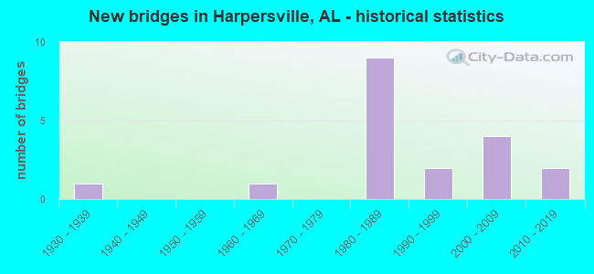
- New bridges - historical statistics
- 11930-1939
- 11960-1969
- 91980-1989
- 21990-1999
- 42000-2009
- 22010-2019


- Bridge Condition - Deck
- 14.3%Very good
- 42.9%Good
- 42.9%Satisfactory

- Bridge Condition - Superstructure
- 14.3%Very good
- 28.6%Good
- 57.1%Satisfactory

- Bridge Condition - Substructure
- 14.3%Very good
- 42.9%Good
- 42.9%Satisfactory

- Bridge Condition - Channel
- 23.5%Very good
- 41.2%Good
- 17.6%Satisfactory
- 17.6%Fair

- Bridge Condition - Culverts
- 83.3%Good
- 16.7%Satisfactory
Find on map >> Show street view
Structure Number: 9755, Location: 1.9 MI N JCT AL 25 (Lat: 33.287833, Lng: -86.418833), Route carried "on" structure: State highway 76, Year Built: 1968, Status: Open, Structure Length: 2.01m (6.59ft), Average Daily Traffic: 2,890 (year 2022), Truck Traffic: 16%, Average Future Daily Traffic: 3,561 (year 2042), Design Load: HS 20, Features Intersected: BRANCH
Minimum Vertical Clearance: 30+ m (98+ ft), Kilometerpoint: 3.075, Lanes on structure: 2, Owner: State Highway Agency, Approaching Roadway Width: 7.3m (24.0ft), Material/Design: Concrete, Design/Construction: Culvert, Number Of Spans In Main Unit: 5, Length of Maximum Span: 3.7m (12.1ft)
Condition: Channel: Satisfactory, Culverts: Satisfactory, Operating Rating: 38.4 metric tons, Method Used To Determine Operating Rating: Load Factor (LF), Inventory Rating: 23.0 metric tons, Method Used To Determine Inventory Rating: Load Factor (LF), Structural Evaluation: Equal to present minimum criteria, Waterway Adequacy: Better than present minimum criteria, Approach Roadway Alignment: Equal to present desirable criteria, Length Of Structure Improvement: 2.76m (9.06ft), Designated Inspection Frequency: Every 24 months, Inspection Date: January 2022, Bridge Improvement Cost: $1,196,000, Roadway Improvement Cost: $120,000, Total Project Cost: $1,316,000 ( Estimate for 2022), Wearing Surface/Protective System: Wearing Surface: Bituminous
Find on map >> Show street view
Structure Number: 11532, Location: .1 MI. E. CO RD 280 (Lat: 33.350450, Lng: -86.467250), Route carried "on" structure: US 280, Year Built: 1931, Year Reconstructed: 1976, Status: Open, Structure Length: 0.98m (3.22ft), Average Daily Traffic: 18,130 (year 2021), Truck Traffic: 14%, Average Future Daily Traffic: 23,848 (year 2041), Design Load: HS 20, Features Intersected: MORGAN CREEK
Minimum Vertical Clearance: 7.56m (24.80ft), Kilometerpoint: 39.257, Lanes on structure: 4, Base Highway Network: Yes, Owner: State Highway Agency, Approaching Roadway Width: 12.2m (40.0ft), Skew: 10 degrees, Material/Design: Concrete, Design/Construction: Culvert, Number Of Spans In Main Unit: 3, Length of Maximum Span: 3.0m (9.8ft)
Condition: Channel: Good, Culverts: Satisfactory, Operating Rating: 63.7 metric tons, Method Used To Determine Operating Rating: Load Factor (LF), Inventory Rating: 38.2 metric tons, Method Used To Determine Inventory Rating: Load Factor (LF), Structural Evaluation: Equal to present minimum criteria, Waterway Adequacy: Equal to present desirable criteria, Approach Roadway Alignment: Equal to present desirable criteria, Length Of Structure Improvement: 1.64m (5.38ft), Designated Inspection Frequency: Every 24 months, Inspection Date: April 2021, Bridge Improvement Cost: $1,481,000, Roadway Improvement Cost: $148,000, Total Project Cost: $1,629,000 ( Estimate for 2022), Wearing Surface/Protective System: Wearing Surface: Bituminous
Find on map >> Show street view
Structure Number: 13006, Location: 0.5 MI. S. OF WEDGEWORTH (Lat: 32.966667, Lng: -87.750000), Route carried "on" structure: County highway 30, Year Built: 1983, Status: Open, Structure Length: 0.64m (2.10ft), Average Daily Traffic: 100 (year 1989), Average Future Daily Traffic: 300 (year 2034), Design Load: H 10, Features Intersected: TRIB. TO DRY CREEK, Facility Carried by Structure: TREE LIMB ROAD
Minimum Vertical Clearance: 30+ m (98+ ft), Kilometerpoint: 0.010, Lanes on structure: 2, Owner: County Highway Agency, Approaching Roadway Width: 8.5m (27.9ft), Material/Design: Concrete, Design/Construction: Culvert, Number Of Spans In Main Unit: 2, Length of Maximum Span: 3.0m (9.8ft), Curb-To-Curb Width: 9.4m (30.8ft), Out-to-Out Width: 9.8m (32.2ft)
Condition: Channel: Good, Culverts: Good, Operating Rating: 68.9 metric tons, Method Used To Determine Operating Rating: Load Factor (LF), Inventory Rating: 41.4 metric tons, Method Used To Determine Inventory Rating: Load Factor (LF), Structural Evaluation: Better than present minimum criteria, Deck Geometry: Better than present minimum criteria, Waterway Adequacy: Better than present minimum criteria, Approach Roadway Alignment: Equal to present minimum criteria, Length Of Structure Improvement: 1.26m (4.13ft), Designated Inspection Frequency: Every 24 months, Inspection Date: June 2020, Bridge Improvement Cost: $233,000, Roadway Improvement Cost: $23,000, Total Project Cost: $256,000 ( Estimate for 2022)
Find on map >> Show street view
Structure Number: 13007, Location: CRAIGMONT * LAUDERDALE (Lat: 34.655000, Lng: -86.578333), Route carried "on" structure: City street , Year Built: 1983, Status: Open, Structure Length: 0.82m (2.69ft), Average Daily Traffic: 460 (year 2017), Truck Traffic: 1%, Average Future Daily Traffic: 644 (year 2037), Design Load: H 20, Features Intersected: BRANCH, Facility Carried by Structure: CRAIGMONT DR
Minimum Vertical Clearance: 30+ m (98+ ft), Kilometerpoint: 0.010, Lanes on structure: 2, Owner: City or Municipal Highway Agency, Approaching Roadway Width: 9.1m (29.9ft), Material/Design: Concrete, Design/Construction: Culvert, Number Of Spans In Main Unit: 2, Length of Maximum Span: 3.7m (12.1ft), Curb or Sidewalk Widths: Left: 2.6m (8.5ft), Right: 2.6m (8.5ft)
Condition: Channel: Very good, Culverts: Good, Operating Rating: 63.7 metric tons, Method Used To Determine Operating Rating: Load Factor (LF), Inventory Rating: 38.2 metric tons, Method Used To Determine Inventory Rating: Load Factor (LF), Structural Evaluation: Better than present minimum criteria, Waterway Adequacy: Better than present minimum criteria, Approach Roadway Alignment: Better than present minimum criteria, Length Of Structure Improvement: 1.48m (4.86ft), Designated Inspection Frequency: Every 24 months, Inspection Date: March 2020, Bridge Improvement Cost: $444,000, Roadway Improvement Cost: $44,000, Total Project Cost: $488,000 ( Estimate for 2022)
Find on map >> Show street view
Structure Number: 13015, Location: .5 MI E.OF US 231 (Lat: 32.270603, Lng: -86.161436), Route carried "on" structure: County highway 101, Year Built: 1983, Status: Open, Structure Length: 2.93m (9.61ft), Average Daily Traffic: 300 (year 1988), Truck Traffic: 1%, Average Future Daily Traffic: 500 (year 2040), Design Load: H 10, Features Intersected: CREEK, Facility Carried by Structure: MERIWETHER ROAD
Minimum Vertical Clearance: 30+ m (98+ ft), Kilometerpoint: 0.010, Lanes on structure: 2, Owner: County Highway Agency, Approaching Roadway Width: 11.0m (36.1ft), Material/Design: Concrete, Design/Construction: Channel Beam, Number Of Spans In Main Unit: 4, Length of Maximum Span: 7.3m (24.0ft), Curb-To-Curb Width: 8.5m (27.9ft), Out-to-Out Width: 9.3m (30.5ft)
Condition: Deck: Good, Superstructure: Good, Substructure: Good, Channel: Satisfactory, Operating Rating: 71.9 metric tons, Method Used To Determine Operating Rating: Allowable Stress (AS), Inventory Rating: 47.1 metric tons, Method Used To Determine Inventory Rating: Allowable Stress (AS), Structural Evaluation: Better than present minimum criteria, Deck Geometry: Equal to present minimum criteria, Waterway Adequacy: Better than present minimum criteria, Approach Roadway Alignment: Equal to present desirable criteria, Length Of Structure Improvement: 3.84m (12.60ft), Designated Inspection Frequency: Every 24 months, Inspection Date: July 2020, Bridge Improvement Cost: $789,000, Roadway Improvement Cost: $79,000, Total Project Cost: $868,000 ( Estimate for 2022), Deck Structure Type: Concrete Precast Panels
Find on map >> Show street view
Structure Number: 13071, Location: 100' S BRIGHTON CL (Lat: 33.425456, Lng: -86.953144), Route carried "on" structure: County highway 59, Year Built: 1983, Status: Open, Structure Length: 3.33m (10.93ft), Average Daily Traffic: 8,378 (year 2019), Truck Traffic: 5%, Average Future Daily Traffic: 11,800 (year 2039), Design Load: HS 20, Features Intersected: VALLEY CREEK, Facility Carried by Structure: JAYBIRD ROAD
Minimum Vertical Clearance: 30+ m (98+ ft), Kilometerpoint: 0.010, Lanes on structure: 2, Owner: County Highway Agency, Approaching Roadway Width: 9.0m (29.5ft), Material/Design: Prestressed concrete, Design/Construction: Box Beam or Girders - Multiple, Number Of Spans In Main Unit: 1, Number Of Approach Spans: 2, Length of Maximum Span: 18.4m (60.4ft), Curb or Sidewalk Widths: Left: 0.3m (1.0ft), Right: 0.3m (1.0ft), Curb-To-Curb Width: 12.7m (41.7ft), Out-to-Out Width: 13.6m (44.6ft)
Condition: Deck: Satisfactory, Superstructure: Satisfactory, Substructure: Satisfactory, Channel: Satisfactory, Operating Rating: 62.7 metric tons, Method Used To Determine Operating Rating: Load Factor (LF), Inventory Rating: 37.6 metric tons, Method Used To Determine Inventory Rating: Load Factor (LF), Structural Evaluation: Equal to present minimum criteria, Deck Geometry: Somewhat better than minimum adequacy, Waterway Adequacy: Somewhat better than minimum adequacy, Approach Roadway Alignment: Equal to present minimum criteria, Length Of Structure Improvement: 4.21m (13.81ft), Designated Inspection Frequency: Every 24 months, Inspection Date: September 2021, Bridge Improvement Cost: $1,271,000, Roadway Improvement Cost: $127,000, Total Project Cost: $1,398,000 ( Estimate for 2022), Deck Structure Type: Concrete Precast Panels
Find on map >> Show street view
Structure Number: 13073, Location: 1000' E OLD TUSC HWY (Lat: 33.334875, Lng: -87.011150), Route carried "on" structure: County highway 451, Year Built: 1983, Status: Open, Structure Length: 0.98m (3.22ft), Average Daily Traffic: 5,180 (year 2022), Truck Traffic: 5%, Average Future Daily Traffic: 7,275 (year 2042), Design Load: HS 20, Features Intersected: CREEK, Facility Carried by Structure: MCADORY SCHOOL RD
Minimum Vertical Clearance: 30+ m (98+ ft), Kilometerpoint: 0.010, Lanes on structure: 2, Owner: County Highway Agency, Approaching Roadway Width: 7.4m (24.3ft), Skew: 1 degrees, Material/Design: Concrete continuous, Design/Construction: Culvert, Number Of Spans In Main Unit: 3, Length of Maximum Span: 3.2m (10.5ft)
Condition: Channel: Fair, Culverts: Good, Operating Rating: 86.7 metric tons, Method Used To Determine Operating Rating: Load Factor (LF), Inventory Rating: 51.9 metric tons, Method Used To Determine Inventory Rating: Load Factor (LF), Structural Evaluation: Better than present minimum criteria, Waterway Adequacy: Equal to present minimum criteria, Approach Roadway Alignment: Better than present minimum criteria, Length Of Structure Improvement: 1.66m (5.45ft), Designated Inspection Frequency: Every 24 months, Inspection Date: January 2022, Bridge Improvement Cost: $728,000, Roadway Improvement Cost: $73,000, Total Project Cost: $801,000 ( Estimate for 2022)
Find on map >> Show street view
Structure Number: 13277, Location: 1.5 MI W JCT I-59 (Lat: 32.874600, Lng: -87.928800), Route carried "on" structure: State highway 14, Year Built: 1984, Status: Open, Structure Length: 1.77m (5.81ft), Average Daily Traffic: 2,207 (year 2020), Truck Traffic: 15%, Average Future Daily Traffic: 3,111 (year 2041), Design Load: HS 20, Features Intersected: Brushy Creek
Minimum Vertical Clearance: 30+ m (98+ ft), Kilometerpoint: 69.097, Lanes on structure: 2, Base Highway Network: Yes, Owner: State Highway Agency, Approaching Roadway Width: 12.8m (42.0ft), Material/Design: Concrete, Design/Construction: Culvert, Number Of Spans In Main Unit: 4, Length of Maximum Span: 4.3m (14.1ft)
Condition: Channel: Fair, Culverts: Good, Operating Rating: 37.3 metric tons, Method Used To Determine Operating Rating: Load Factor (LF), Inventory Rating: 22.3 metric tons, Method Used To Determine Inventory Rating: Load Factor (LF), Structural Evaluation: Somewhat better than minimum adequacy, Waterway Adequacy: Somewhat better than minimum adequacy, Approach Roadway Alignment: Equal to present minimum criteria, Length Of Structure Improvement: 2.47m (8.10ft), Designated Inspection Frequency: Every 24 months, Inspection Date: November 2021, Bridge Improvement Cost: $1,356,000, Roadway Improvement Cost: $136,000, Total Project Cost: $1,492,000 ( Estimate for 2022)
Find on map >> Show street view
Structure Number: 13355, Location: 1.5 MI W PICKENSVILLE (Lat: 33.225725, Lng: -88.292072), Route carried "on" structure: State highway 86, Year Built: 1984, Status: Open, Structure Length: 84.98m (278.81ft), Average Daily Traffic: 1,653 (year 2020), Truck Traffic: 14%, Average Future Daily Traffic: 1,891 (year 2040), Design Load: HS 20, Features Intersected: Tombigbee River
Minimum Vertical Clearance: 30+ m (98+ ft), Kilometerpoint: 2.055, Lanes on structure: 2, Owner: State Highway Agency, Approaching Roadway Width: 11.0m (36.1ft), Navigation Control: Yes ( Vertical Clearance: 15.8m (51.8ft), Horizontal Clearance: 109.7m (359.9ft)), Material/Design: Steel continuous, Design/Construction: Girder and Floorbeam System, Number Of Spans In Main Unit: 3, Number Of Approach Spans: 18, Length of Maximum Span: 114.3m (375.0ft), Curb-To-Curb Width: 10.4m (34.1ft), Out-to-Out Width: 11.2m (36.7ft)
Condition: Deck: Satisfactory, Superstructure: Satisfactory, Substructure: Satisfactory, Channel: Good, Operating Rating: 52.1 metric tons, Method Used To Determine Operating Rating: Load Factor (LF), Inventory Rating: 31.2 metric tons, Method Used To Determine Inventory Rating: Load Factor (LF), Structural Evaluation: Equal to present minimum criteria, Deck Geometry: Equal to present minimum criteria, Waterway Adequacy: Equal to present desirable criteria, Approach Roadway Alignment: Equal to present minimum criteria, Length Of Structure Improvement: 84.98m (278.81ft), Designated Inspection Frequency: Every 24 months, Critical Feature Inspection Frequency: Every 24 months, Underwater Inspection Frequency: Every 24 months, Inspection Date: March 2020, Critical Feature Inspection Date: March 2020, Underwater Inspection Date: August 2020, Bridge Improvement Cost: $20,978,000, Roadway Improvement Cost: $2,098,000, Total Project Cost: $23,076,000 ( Estimate for 2022), Deck Structure Type: Concrete Cast-file-Place
Find on map >> Show street view
Structure Number: 13646, Location: .8 MI W. AL 25 (Lat: 33.346900, Lng: -86.450500), Route carried "on" structure: US 280, Year Built: 1985, Status: Open, Structure Length: 4.94m (16.21ft), Average Daily Traffic: 8,810 (year 2019), Truck Traffic: 13%, Average Future Daily Traffic: 11,588 (year 2039), Design Load: HS 20, Features Intersected: SCL RR, Facility Carried by Structure: AL - 38 WEST
Minimum Vertical Clearance: 30+ m (98+ ft), Kilometerpoint: 42.326, Lanes on structure: 2, Base Highway Network: Yes, Owner: State Highway Agency, Approaching Roadway Width: 12.2m (40.0ft), Skew: 4 degrees, Material/Design: Prestressed concrete, Design/Construction: Stringer/Multi-beam, Number Of Spans In Main Unit: 3, Length of Maximum Span: 18.3m (60.0ft), Curb-To-Curb Width: 12.2m (40.0ft), Out-to-Out Width: 13.1m (43.0ft)
Condition: Deck: Good, Superstructure: Satisfactory, Substructure: Satisfactory, Operating Rating: 66.2 metric tons, Method Used To Determine Operating Rating: Load Factor (LF), Inventory Rating: 37.1 metric tons, Method Used To Determine Inventory Rating: Load Factor (LF), Structural Evaluation: Equal to present minimum criteria, Deck Geometry: Better than present minimum criteria, Underclear: Superior to present desirable criteria, Approach Roadway Alignment: Equal to present desirable criteria, Length Of Structure Improvement: 5.95m (19.52ft), Designated Inspection Frequency: Every 24 months, Inspection Date: January 2022, Bridge Improvement Cost: $1,755,000, Roadway Improvement Cost: $176,000, Total Project Cost: $1,931,000 ( Estimate for 2022), Deck Structure Type: Concrete Cast-file-Place
Find on map >> Show street view
Structure Number: 13647, Location: US 280 * SCL RR (Lat: 33.346817, Lng: -86.451383), Route carried "on" structure: US 280, Year Built: 1985, Status: Open, Structure Length: 4.94m (16.21ft), Average Daily Traffic: 8,810 (year 2022), Truck Traffic: 13%, Average Future Daily Traffic: 11,588 (year 2042), Design Load: HS 20, Features Intersected: SCL RR, Facility Carried by Structure: AL - 38 EAST
Minimum Vertical Clearance: 30+ m (98+ ft), Kilometerpoint: 42.326, Lanes on structure: 2, Base Highway Network: Yes, Owner: State Highway Agency, Approaching Roadway Width: 12.2m (40.0ft), Skew: 4 degrees, Material/Design: Prestressed concrete continuous, Design/Construction: Stringer/Multi-beam, Number Of Spans In Main Unit: 3, Length of Maximum Span: 18.3m (60.0ft), Curb-To-Curb Width: 12.2m (40.0ft), Out-to-Out Width: 13.1m (43.0ft)
Condition: Deck: Good, Superstructure: Satisfactory, Substructure: Good, Operating Rating: 66.2 metric tons, Method Used To Determine Operating Rating: Load Factor (LF), Inventory Rating: 37.2 metric tons, Method Used To Determine Inventory Rating: Load Factor (LF), Structural Evaluation: Equal to present minimum criteria, Deck Geometry: Better than present minimum criteria, Underclear: Superior to present desirable criteria, Approach Roadway Alignment: Equal to present desirable criteria, Length Of Structure Improvement: 5.95m (19.52ft), Designated Inspection Frequency: Every 24 months, Inspection Date: January 2022, Bridge Improvement Cost: $1,755,000, Roadway Improvement Cost: $176,000, Total Project Cost: $1,931,000 ( Estimate for 2022), Deck Structure Type: Concrete Cast-file-Place
Find on map >> Show street view
Structure Number: 1556, Location: AL 76 * LOGAN BRANCH (Lat: 33.300483, Lng: -86.386933), Route carried "on" structure: State highway 76, Year Built: 1992, Status: Open, Structure Length: 1.04m (3.41ft), Average Daily Traffic: 3,170 (year 2020), Truck Traffic: 16%, Average Future Daily Traffic: 3,906 (year 2040), Design Load: HS 20, Features Intersected: LOGAN BRANCH
Minimum Vertical Clearance: 30+ m (98+ ft), Kilometerpoint: 6.280, Lanes on structure: 2, Owner: State Highway Agency, Approaching Roadway Width: 7.3m (24.0ft), Skew: 10 degrees, Material/Design: Concrete, Design/Construction: Culvert, Number Of Spans In Main Unit: 3, Length of Maximum Span: 3.0m (9.8ft), Out-to-Out Width: 7.3m (24.0ft)
Condition: Channel: Very good, Culverts: Good, Operating Rating: 56.2 metric tons, Method Used To Determine Operating Rating: Load Factor (LF), Inventory Rating: 33.7 metric tons, Method Used To Determine Inventory Rating: Load Factor (LF), Structural Evaluation: Better than present minimum criteria, Waterway Adequacy: Equal to present desirable criteria, Approach Roadway Alignment: Equal to present desirable criteria, Length Of Structure Improvement: 1.71m (5.61ft), Designated Inspection Frequency: Every 24 months, Inspection Date: December 2020, Bridge Improvement Cost: $485,000, Roadway Improvement Cost: $49,000, Total Project Cost: $534,000 ( Estimate for 2022), Wearing Surface/Protective System: Wearing Surface: Bituminous
Find on map >> Show street view
Structure Number: 17396, Location: .5 MI. W JCT. ST 25 (Lat: 33.290272, Lng: -86.455867), Route carried "on" structure: County highway , Year Built: 1998, Status: Open, Structure Length: 1.13m (3.71ft), Average Daily Traffic: 202 (year 2020), Truck Traffic: 10%, Average Future Daily Traffic: 349 (year 2040), Design Load: HS 20, Features Intersected: MORGAN CREEK, Facility Carried by Structure: DEAD HOLLOW ROAD
Minimum Vertical Clearance: 30+ m (98+ ft), Kilometerpoint: 0.000, Lanes on structure: 2, Owner: County Highway Agency, Approaching Roadway Width: 6.2m (20.3ft), Material/Design: Concrete, Design/Construction: Culvert, Number Of Spans In Main Unit: 4, Length of Maximum Span: 2.4m (7.9ft)
Condition: Channel: Fair, Culverts: Good, Operating Rating: 88.9 metric tons, Method Used To Determine Operating Rating: Load Factor (LF), Inventory Rating: 53.5 metric tons, Method Used To Determine Inventory Rating: Load Factor (LF), Structural Evaluation: Better than present minimum criteria, Waterway Adequacy: Better than present minimum criteria, Approach Roadway Alignment: Somewhat better than minimum adequacy, Length Of Structure Improvement: 1.80m (5.91ft), Designated Inspection Frequency: Every 24 months, Inspection Date: May 2020, Bridge Improvement Cost: $385,000, Roadway Improvement Cost: $39,000, Total Project Cost: $424,000 ( Estimate for 2022)
Find on map >> Show street view
Structure Number: 18185, Location: .2 MI FROM INT CR 85 *463 (Lat: 33.336906, Lng: -86.382319), Route carried "on" structure: County highway 85, Year Built: 2003, Status: Open, Structure Length: 3.66m (12.01ft), Average Daily Traffic: 1,278 (year 2021), Average Future Daily Traffic: 1,790 (year 2041), Design Load: HS 20, Features Intersected: LOCUST CREEK
Minimum Vertical Clearance: 30+ m (98+ ft), Kilometerpoint: 0.000, Lanes on structure: 2, Owner: County Highway Agency, Approaching Roadway Width: 7.0m (23.0ft), Material/Design: Prestressed concrete, Design/Construction: Stringer/Multi-beam, Number Of Spans In Main Unit: 3, Length of Maximum Span: 12.2m (40.0ft), Curb-To-Curb Width: 8.5m (27.9ft), Out-to-Out Width: 9.4m (30.8ft)
Condition: Deck: Satisfactory, Superstructure: Good, Substructure: Very good, Channel: Good, Operating Rating: 65.1 metric tons, Method Used To Determine Operating Rating: Load Factor (LF), Inventory Rating: 39.0 metric tons, Method Used To Determine Inventory Rating: Load Factor (LF), Structural Evaluation: Better than present minimum criteria, Deck Geometry: Somewhat better than minimum adequacy, Waterway Adequacy: Equal to present minimum criteria, Approach Roadway Alignment: Equal to present desirable criteria, Length Of Structure Improvement: 4.58m (15.03ft), Designated Inspection Frequency: Every 24 months, Inspection Date: September 2021, Bridge Improvement Cost: $942,000, Roadway Improvement Cost: $94,000, Total Project Cost: $1,036,000 ( Estimate for 2022), Deck Structure Type: Concrete Cast-file-Place
Find on map >> Show street view
Structure Number: 19452, Location: .25 MI. FROM AL 25 (Lat: 33.336250, Lng: -86.442425), Route carried "on" structure: County highway 444, Year Built: 2004, Status: Open, Structure Length: 1.22m (4.00ft), Average Daily Traffic: 250 (year 2020), Truck Traffic: 2%, Average Future Daily Traffic: 245 (year 2040), Design Load: HS 20, Features Intersected: TANYARD BRANCH
Minimum Vertical Clearance: 30+ m (98+ ft), Kilometerpoint: 0.000, Lanes on structure: 2, Owner: County Highway Agency, Approaching Roadway Width: 6.7m (22.0ft), Material/Design: Concrete, Design/Construction: Channel Beam, Number Of Spans In Main Unit: 1, Length of Maximum Span: 12.2m (40.0ft), Curb-To-Curb Width: 8.6m (28.2ft), Out-to-Out Width: 9.2m (30.2ft)
Condition: Deck: Very good, Superstructure: Very good, Substructure: Good, Channel: Very good, Operating Rating: 88.9 metric tons, Method Used To Determine Operating Rating: Load Factor (LF), Inventory Rating: 55.1 metric tons, Method Used To Determine Inventory Rating: Load Factor (LF), Structural Evaluation: Better than present minimum criteria, Deck Geometry: Equal to present minimum criteria, Waterway Adequacy: Equal to present desirable criteria, Approach Roadway Alignment: Equal to present desirable criteria, Length Of Structure Improvement: 1.89m (6.20ft), Designated Inspection Frequency: Every 24 months, Inspection Date: September 2020, Bridge Improvement Cost: $389,000, Roadway Improvement Cost: $39,000, Total Project Cost: $428,000 ( Estimate for 2022), Deck Structure Type: Concrete Precast Panels
Find on map >> Show street view
Structure Number: 19935, Location: 0.4 MI WEST AL 25 (Lat: 33.342364, Lng: -86.445253), Route carried "on" structure: County highway 434, Year Built: 2007, Status: Open, Structure Length: 0.72m (2.36ft), Average Daily Traffic: 100 (year 2021), Average Future Daily Traffic: 140 (year 2041), Design Load: HS 20, Features Intersected: W. FORK TANYARD BRANCH
Minimum Vertical Clearance: 30+ m (98+ ft), Kilometerpoint: 0.000, Lanes on structure: 2, Owner: County Highway Agency, Approaching Roadway Width: 6.7m (22.0ft), Skew: 3 degrees, Material/Design: Concrete, Design/Construction: Culvert, Number Of Spans In Main Unit: 2, Length of Maximum Span: 3.0m (9.8ft)
Condition: Channel: Good, Culverts: Good, Operating Rating: 84.6 metric tons, Method Used To Determine Operating Rating: Load Factor (LF), Inventory Rating: 50.8 metric tons, Method Used To Determine Inventory Rating: Load Factor (LF), Structural Evaluation: Better than present minimum criteria, Waterway Adequacy: Equal to present desirable criteria, Approach Roadway Alignment: Equal to present desirable criteria, Length Of Structure Improvement: 1.35m (4.43ft), Designated Inspection Frequency: Every 24 months, Inspection Date: June 2021, Bridge Improvement Cost: $375,000, Roadway Improvement Cost: $38,000, Total Project Cost: $413,000 ( Estimate for 2022)
Find on map >> Show street view
Structure Number: 20227, Location: 0.6 MI FROM AL 25 (Lat: 33.302303, Lng: -86.455503), Route carried "on" structure: County highway , Year Built: 2009, Status: Open, Structure Length: 1.13m (3.71ft), Average Daily Traffic: 100 (year 2021), Truck Traffic: 1%, Average Future Daily Traffic: 140 (year 2041), Design Load: HS 20, Features Intersected: MORGAN CREEK, Facility Carried by Structure: DEAD HOLLOW ROAD
Minimum Vertical Clearance: 30+ m (98+ ft), Kilometerpoint: 0.000, Lanes on structure: 2, Owner: County Highway Agency, Approaching Roadway Width: 6.1m (20.0ft), Material/Design: Concrete, Design/Construction: Culvert, Number Of Spans In Main Unit: 3, Length of Maximum Span: 3.7m (12.1ft)
Condition: Channel: Good, Culverts: Good, Operating Rating: 57.7 metric tons, Method Used To Determine Operating Rating: Load Factor (LF), Inventory Rating: 34.7 metric tons, Method Used To Determine Inventory Rating: Load Factor (LF), Structural Evaluation: Better than present minimum criteria, Waterway Adequacy: Equal to present minimum criteria, Approach Roadway Alignment: Better than present minimum criteria, Length Of Structure Improvement: 1.80m (5.91ft), Designated Inspection Frequency: Every 24 months, Inspection Date: April 2021, Bridge Improvement Cost: $416,000, Roadway Improvement Cost: $42,000, Total Project Cost: $458,000 ( Estimate for 2022)
Find on map >> Show street view
Structure Number: 21276, Location: 0.1 MI. West JCT AL 25 (Lat: 33.302272, Lng: -86.446825), Route carried "on" structure: County highway , Year Built: 2016, Status: Open, Structure Length: 0.84m (2.76ft), Average Daily Traffic: 150 (year 2020), Truck Traffic: 2%, Average Future Daily Traffic: 210 (year 2040), Design Load: HS 20, Features Intersected: Tanyard Branch, Facility Carried by Structure: Dead Hollow Road
Minimum Vertical Clearance: 30+ m (98+ ft), Kilometerpoint: 0.010, Lanes on structure: 1, Owner: County Highway Agency, Approaching Roadway Width: 4.9m (16.1ft), Material/Design: Concrete, Design/Construction: Culvert, Number Of Spans In Main Unit: 3, Length of Maximum Span: 2.4m (7.9ft)
Condition: Channel: Very good, Culverts: Good, Operating Rating: 55.2 metric tons, Method Used To Determine Operating Rating: Load Factor (LF), Inventory Rating: 33.1 metric tons, Method Used To Determine Inventory Rating: Load Factor (LF), Structural Evaluation: Better than present minimum criteria, Waterway Adequacy: Meets minimum limits, Approach Roadway Alignment: Equal to present minimum criteria, Length Of Structure Improvement: 1.50m (4.92ft), Designated Inspection Frequency: Every 24 months, Inspection Date: July 2020, Bridge Improvement Cost: $243,000, Roadway Improvement Cost: $24,000, Total Project Cost: $267,000 ( Estimate for 2022)
Find on map >> Show street view
Structure Number: 21546, Location: _0.25 MI from Narrow Road (Lat: 33.314600, Lng: -86.456853), Route carried "on" structure: County highway , Year Built: 2019, Status: Open, Structure Length: 0.68m (2.23ft), Average Daily Traffic: 50 (year 2021), Truck Traffic: 1%, Average Future Daily Traffic: 70 (year 2041), Design Load: HS 20, Features Intersected: _MORGAN CREEK, Facility Carried by Structure: Dead Holl. Rd. N
Minimum Vertical Clearance: 30+ m (98+ ft), Kilometerpoint: 0.000, Lanes on structure: 2, Owner: County Highway Agency, Approaching Roadway Width: 4.3m (14.1ft), Material/Design: Concrete, Design/Construction: Culvert, Number Of Spans In Main Unit: 2, Length of Maximum Span: 3.0m (9.8ft)
Condition: Channel: Good, Culverts: Good, Operating Rating: 56.3 metric tons, Method Used To Determine Operating Rating: Load Factor (LF), Inventory Rating: 33.7 metric tons, Method Used To Determine Inventory Rating: Load Factor (LF), Structural Evaluation: Better than present minimum criteria, Waterway Adequacy: Equal to present minimum criteria, Approach Roadway Alignment: Equal to present minimum criteria, Length Of Structure Improvement: 1.31m (4.30ft), Designated Inspection Frequency: Every 24 months, Inspection Date: December 2021, Bridge Improvement Cost: $256,000, Roadway Improvement Cost: $26,000, Total Project Cost: $282,000 ( Estimate for 2022)