Bridge Statistics for Glenrock, Wyoming (WY)
Condition, Traffic, Stress, Structural Evaluation, Project Costs
- National Bridge Inventory (NBI) Statistics
- 24Number of bridges
- 246ft / 75.0mTotal length
- 74,938Total average daily traffic
- 13,741Total average daily truck traffic
- National Bridge Inventory (NBI) Registered Bridges for Glenrock
- No street view available for this location
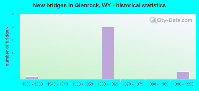
- New bridges - historical statistics
- 11930-1939
- 201960-1969
- 31990-1999


- Bridge Condition - Deck
- 12.5%Good
- 50.0%Satisfactory
- 37.5%Fair

- Bridge Condition - Superstructure
- 62.5%Good
- 31.3%Satisfactory
- 6.3%Fair

- Bridge Condition - Substructure
- 75.0%Good
- 25.0%Satisfactory

- Bridge Condition - Channel
- 16.7%Very good
- 50.0%Good
- 16.7%Satisfactory
- 16.7%Fair
Find on map >> Show street view
Structure Number: AGX, Location: Douglas - Casper (Lat: 42.824153, Lng: -105.797286), Route carried "on" structure: Interstate 25, Year Built: 1967, Status: Open, Structure Length: 3.66m (12.01ft), Average Daily Traffic: 4,707 (year 2021), Truck Traffic: 33%, Average Future Daily Traffic: 6,590 (year 2041), Design Load: HS 20+Mod, Features Intersected: East Glenrock Intg
Minimum Vertical Clearance: 30+ m (98+ ft), Kilometerpoint: 258.438, Lanes on structure: 2, Lanes under structure: 2, Base Highway Network: Yes, Owner: State Highway Agency, Approaching Roadway Width: 11.6m (38.1ft), Skew: 10 degrees, Material/Design: Concrete continuous, Design/Construction: Tee Beam, Number Of Spans In Main Unit: 3, Length of Maximum Span: 14.3m (46.9ft), Curb-To-Curb Width: 11.6m (38.1ft), Out-to-Out Width: 12.4m (40.7ft)
Condition: Deck: Satisfactory, Superstructure: Good, Substructure: Satisfactory, Operating Rating: 50.0 metric tons, Method Used To Determine Operating Rating: Load Factor (LF), Inventory Rating: 29.8 metric tons, Method Used To Determine Inventory Rating: Load Factor (LF), Structural Evaluation: Equal to present minimum criteria, Deck Geometry: Equal to present minimum criteria, Underclear: Meets minimum limits, Approach Roadway Alignment: Equal to present desirable criteria, Designated Inspection Frequency: Every 24 months, Inspection Date: April 2021, Deck Structure Type: Concrete Cast-file-Place
Find on map >> Show street view
Structure Number: AGY, Location: Douglas - Casper (Lat: 42.823964, Lng: -105.797333), Route carried "on" structure: Interstate 25, Year Built: 1967, Status: Open, Structure Length: 3.66m (12.01ft), Average Daily Traffic: 4,530 (year 2021), Truck Traffic: 20%, Average Future Daily Traffic: 6,342 (year 2041), Design Load: HS 20+Mod, Features Intersected: East Glenrock Intg
Minimum Vertical Clearance: 30.48m (100.00ft), Kilometerpoint: 258.446, Lanes on structure: 2, Lanes under structure: 2, Base Highway Network: Yes, Owner: State Highway Agency, Approaching Roadway Width: 11.6m (38.1ft), Skew: 10 degrees, Material/Design: Concrete continuous, Design/Construction: Tee Beam, Number Of Spans In Main Unit: 3, Length of Maximum Span: 14.3m (46.9ft), Curb-To-Curb Width: 11.6m (38.1ft), Out-to-Out Width: 12.4m (40.7ft)
Condition: Deck: Good, Superstructure: Satisfactory, Substructure: Satisfactory, Operating Rating: 50.0 metric tons, Method Used To Determine Operating Rating: Load Factor (LF), Inventory Rating: 29.8 metric tons, Method Used To Determine Inventory Rating: Load Factor (LF), Structural Evaluation: Equal to present minimum criteria, Deck Geometry: Equal to present minimum criteria, Underclear: Meets minimum limits, Approach Roadway Alignment: Equal to present desirable criteria, Designated Inspection Frequency: Every 24 months, Inspection Date: April 2021, Deck Structure Type: Concrete Cast-file-Place, Wearing Surface/Protective System: Wearing Surface: Bituminous, Membrane: Preformed Fabric
Find on map >> Show street view
Structure Number: AGZ, Location: Douglas - Casper (Lat: 42.826914, Lng: -105.819906), Route carried "on" structure: Interstate 25, Year Built: 1967, Status: Open, Structure Length: 3.54m (11.61ft), Average Daily Traffic: 4,659 (year 2021), Truck Traffic: 20%, Average Future Daily Traffic: 6,523 (year 2041), Design Load: HS 20+Mod, Features Intersected: WYO 90
Minimum Vertical Clearance: 30+ m (98+ ft), Kilometerpoint: 260.313, Lanes on structure: 2, Lanes under structure: 2, Base Highway Network: Yes, Owner: State Highway Agency, Approaching Roadway Width: 11.6m (38.1ft), Skew: 12 degrees, Material/Design: Steel continuous, Design/Construction: Stringer/Multi-beam, Number Of Spans In Main Unit: 3, Length of Maximum Span: 13.4m (44.0ft), Curb-To-Curb Width: 11.6m (38.1ft), Out-to-Out Width: 12.4m (40.7ft)
Condition: Deck: Satisfactory, Superstructure: Good, Substructure: Good, Operating Rating: 48.1 metric tons, Method Used To Determine Operating Rating: Load Factor (LF), Inventory Rating: 28.1 metric tons, Method Used To Determine Inventory Rating: Load Factor (LF), Structural Evaluation: Better than present minimum criteria, Deck Geometry: Equal to present minimum criteria, Underclear: Somewhat better than minimum adequacy, Approach Roadway Alignment: Equal to present desirable criteria, Designated Inspection Frequency: Every 24 months, Inspection Date: April 2021, Deck Structure Type: Concrete Cast-file-Place
Find on map >> Show street view
Structure Number: AHA, Location: Douglas - Casper (Lat: 42.826739, Lng: -105.820050), Route carried "on" structure: Interstate 25, Year Built: 1967, Status: Open, Structure Length: 3.54m (11.61ft), Average Daily Traffic: 4,505 (year 2021), Truck Traffic: 20%, Average Future Daily Traffic: 6,307 (year 2041), Design Load: HS 20+Mod, Features Intersected: WYO 90
Minimum Vertical Clearance: 30+ m (98+ ft), Kilometerpoint: 260.329, Lanes on structure: 2, Lanes under structure: 2, Base Highway Network: Yes, Owner: State Highway Agency, Approaching Roadway Width: 11.6m (38.1ft), Skew: 12 degrees, Material/Design: Steel continuous, Design/Construction: Stringer/Multi-beam, Number Of Spans In Main Unit: 3, Length of Maximum Span: 13.4m (44.0ft), Curb-To-Curb Width: 11.6m (38.1ft), Out-to-Out Width: 12.4m (40.7ft)
Condition: Deck: Satisfactory, Superstructure: Satisfactory, Substructure: Good, Operating Rating: 48.1 metric tons, Method Used To Determine Operating Rating: Load Factor (LF), Inventory Rating: 28.1 metric tons, Method Used To Determine Inventory Rating: Load Factor (LF), Structural Evaluation: Equal to present minimum criteria, Deck Geometry: Equal to present minimum criteria, Underclear: Somewhat better than minimum adequacy, Approach Roadway Alignment: Equal to present desirable criteria, Designated Inspection Frequency: Every 24 months, Inspection Date: April 2021, Deck Structure Type: Concrete Cast-file-Place
Find on map >> Show street view
Structure Number: AHB, Location: Douglas - Casper (Lat: 42.836297, Lng: -105.855286), Route carried "on" structure: Interstate 25, Year Built: 1967, Status: Open, Structure Length: 2.96m (9.71ft), Average Daily Traffic: 4,659 (year 2021), Truck Traffic: 20%, Average Future Daily Traffic: 6,523 (year 2041), Design Load: HS 20+Mod, Features Intersected: CR 18/Mormon Canyon Rd
Minimum Vertical Clearance: 30+ m (98+ ft), Kilometerpoint: 263.390, Lanes on structure: 2, Lanes under structure: 2, Base Highway Network: Yes, Owner: State Highway Agency, Approaching Roadway Width: 11.6m (38.1ft), Skew: 10 degrees, Material/Design: Concrete continuous, Design/Construction: Tee Beam, Number Of Spans In Main Unit: 3, Length of Maximum Span: 11.3m (37.1ft), Curb-To-Curb Width: 11.6m (38.1ft), Out-to-Out Width: 12.3m (40.4ft)
Condition: Deck: Satisfactory, Superstructure: Good, Substructure: Good, Operating Rating: 51.7 metric tons, Method Used To Determine Operating Rating: Load Factor (LF), Inventory Rating: 30.8 metric tons, Method Used To Determine Inventory Rating: Load Factor (LF), Structural Evaluation: Better than present minimum criteria, Deck Geometry: Equal to present minimum criteria, Underclear: Somewhat better than minimum adequacy, Approach Roadway Alignment: Equal to present desirable criteria, Designated Inspection Frequency: Every 24 months, Inspection Date: June 2020, Deck Structure Type: Concrete Cast-file-Place, Wearing Surface/Protective System: Membrane: Preformed Fabric
Find on map >> Show street view
Structure Number: AHC, Location: Douglas - Casper (Lat: 42.835903, Lng: -105.855489), Route carried "on" structure: Interstate 25, Year Built: 1967, Status: Open, Structure Length: 2.96m (9.71ft), Average Daily Traffic: 4,505 (year 2021), Truck Traffic: 20%, Average Future Daily Traffic: 6,307 (year 2041), Design Load: HS 20+Mod, Features Intersected: CR 18/Mormon Canyon Rd
Minimum Vertical Clearance: 30+ m (98+ ft), Kilometerpoint: 263.403, Lanes on structure: 2, Lanes under structure: 2, Base Highway Network: Yes, Owner: State Highway Agency, Approaching Roadway Width: 11.6m (38.1ft), Skew: 10 degrees, Material/Design: Concrete continuous, Design/Construction: Tee Beam, Number Of Spans In Main Unit: 3, Length of Maximum Span: 11.3m (37.1ft), Curb-To-Curb Width: 11.6m (38.1ft), Out-to-Out Width: 12.3m (40.4ft)
Condition: Deck: Good, Superstructure: Good, Substructure: Good, Operating Rating: 51.7 metric tons, Method Used To Determine Operating Rating: Load Factor (LF), Inventory Rating: 30.8 metric tons, Method Used To Determine Inventory Rating: Load Factor (LF), Structural Evaluation: Better than present minimum criteria, Deck Geometry: Equal to present minimum criteria, Underclear: Somewhat better than minimum adequacy, Approach Roadway Alignment: Equal to present desirable criteria, Designated Inspection Frequency: Every 24 months, Inspection Date: June 2020, Deck Structure Type: Concrete Cast-file-Place, Wearing Surface/Protective System: Membrane: Preformed Fabric
Find on map >> Show street view
Structure Number: AHD, Location: Douglas - Casper (Lat: 42.837375, Lng: -105.867544), Route carried "on" structure: Interstate 25, Year Built: 1967, Status: Open, Structure Length: 1.89m (6.20ft), Average Daily Traffic: 4,659 (year 2021), Truck Traffic: 20%, Average Future Daily Traffic: 6,523 (year 2041), Design Load: HS 20+Mod, Features Intersected: Machinery Pass
Minimum Vertical Clearance: 30+ m (98+ ft), Kilometerpoint: 264.409, Lanes on structure: 2, Base Highway Network: Yes, Owner: State Highway Agency, Approaching Roadway Width: 11.6m (38.1ft), Skew: 10 degrees, Material/Design: Concrete continuous, Design/Construction: Tee Beam, Number Of Spans In Main Unit: 3, Length of Maximum Span: 7.2m (23.6ft), Curb-To-Curb Width: 11.6m (38.1ft), Out-to-Out Width: 12.4m (40.7ft)
Condition: Deck: Fair, Superstructure: Satisfactory, Substructure: Good, Operating Rating: 48.1 metric tons, Method Used To Determine Operating Rating: Load Factor (LF), Inventory Rating: 28.1 metric tons, Method Used To Determine Inventory Rating: Load Factor (LF), Structural Evaluation: Equal to present minimum criteria, Deck Geometry: Equal to present minimum criteria, Approach Roadway Alignment: Equal to present desirable criteria, Designated Inspection Frequency: Every 24 months, Inspection Date: March 2020, Deck Structure Type: Concrete Cast-file-Place
Find on map >> Show street view
Structure Number: AHE, Location: Douglas - Casper (Lat: 42.836964, Lng: -105.867547), Route carried "on" structure: Interstate 25, Year Built: 1967, Status: Open, Structure Length: 1.89m (6.20ft), Average Daily Traffic: 4,505 (year 2021), Truck Traffic: 20%, Average Future Daily Traffic: 6,307 (year 2041), Design Load: HS 20+Mod, Features Intersected: Machinery Pass
Minimum Vertical Clearance: 30+ m (98+ ft), Kilometerpoint: 264.404, Lanes on structure: 2, Base Highway Network: Yes, Owner: State Highway Agency, Approaching Roadway Width: 11.6m (38.1ft), Skew: 10 degrees, Material/Design: Concrete continuous, Design/Construction: Tee Beam, Number Of Spans In Main Unit: 3, Length of Maximum Span: 7.2m (23.6ft), Curb-To-Curb Width: 11.6m (38.1ft), Out-to-Out Width: 12.4m (40.7ft)
Condition: Deck: Satisfactory, Superstructure: Satisfactory, Substructure: Good, Operating Rating: 48.1 metric tons, Method Used To Determine Operating Rating: Load Factor (LF), Inventory Rating: 28.1 metric tons, Method Used To Determine Inventory Rating: Load Factor (LF), Structural Evaluation: Equal to present minimum criteria, Deck Geometry: Equal to present minimum criteria, Approach Roadway Alignment: Equal to present desirable criteria, Designated Inspection Frequency: Every 24 months, Inspection Date: March 2020, Deck Structure Type: Concrete Cast-file-Place
Find on map >> Show street view
Structure Number: AHF, Location: Douglas - Casper (Lat: 42.837342, Lng: -105.872533), Route carried "on" structure: Interstate 25, Year Built: 1967, Status: Open, Structure Length: 5.70m (18.70ft), Average Daily Traffic: 4,659 (year 2021), Truck Traffic: 20%, Average Future Daily Traffic: 6,523 (year 2041), Design Load: HS 20+Mod, Features Intersected: Deer Creek
Minimum Vertical Clearance: 30+ m (98+ ft), Kilometerpoint: 264.816, Lanes on structure: 2, Base Highway Network: Yes, Owner: State Highway Agency, Approaching Roadway Width: 11.6m (38.1ft), Skew: 14 degrees, Material/Design: Steel continuous, Design/Construction: Stringer/Multi-beam, Number Of Spans In Main Unit: 3, Length of Maximum Span: 23.7m (77.8ft), Curb-To-Curb Width: 11.6m (38.1ft), Out-to-Out Width: 12.4m (40.7ft)
Condition: Deck: Satisfactory, Superstructure: Good, Substructure: Good, Channel: Good, Operating Rating: 49.0 metric tons, Method Used To Determine Operating Rating: Load Factor (LF), Inventory Rating: 29.0 metric tons, Method Used To Determine Inventory Rating: Load Factor (LF), Structural Evaluation: Better than present minimum criteria, Deck Geometry: Equal to present minimum criteria, Waterway Adequacy: Equal to present desirable criteria, Approach Roadway Alignment: Equal to present desirable criteria, Designated Inspection Frequency: Every 24 months, Inspection Date: March 2020, Deck Structure Type: Concrete Cast-file-Place, Wearing Surface/Protective System: Wearing Surface: Other
Find on map >> Show street view
Structure Number: AHG, Location: Douglas - Casper (Lat: 42.836914, Lng: -105.873014), Route carried "on" structure: Interstate 25, Year Built: 1967, Status: Open, Structure Length: 5.70m (18.70ft), Average Daily Traffic: 4,505 (year 2021), Truck Traffic: 20%, Average Future Daily Traffic: 6,307 (year 2041), Design Load: HS 20+Mod, Features Intersected: Deer Creek
Minimum Vertical Clearance: 30+ m (98+ ft), Kilometerpoint: 264.851, Lanes on structure: 2, Base Highway Network: Yes, Owner: State Highway Agency, Approaching Roadway Width: 11.6m (38.1ft), Skew: 14 degrees, Material/Design: Steel continuous, Design/Construction: Stringer/Multi-beam, Number Of Spans In Main Unit: 3, Length of Maximum Span: 23.7m (77.8ft), Curb-To-Curb Width: 11.6m (38.1ft), Out-to-Out Width: 12.4m (40.7ft)
Condition: Deck: Fair, Superstructure: Good, Substructure: Good, Channel: Good, Operating Rating: 47.2 metric tons, Method Used To Determine Operating Rating: Load Factor (LF), Inventory Rating: 28.1 metric tons, Method Used To Determine Inventory Rating: Load Factor (LF), Structural Evaluation: Better than present minimum criteria, Deck Geometry: Equal to present minimum criteria, Waterway Adequacy: Equal to present desirable criteria, Approach Roadway Alignment: Equal to present desirable criteria, Designated Inspection Frequency: Every 24 months, Inspection Date: March 2020, Deck Structure Type: Concrete Cast-file-Place, Wearing Surface/Protective System: Wearing Surface: Latex Concrete
Find on map >> Show street view
Structure Number: AHH, Location: Douglas - Casper (Lat: 42.837153, Lng: -105.893317), Route carried "on" structure: Interstate 25, Year Built: 1967, Status: Open, Structure Length: 5.88m (19.29ft), Average Daily Traffic: 4,659 (year 2021), Truck Traffic: 20%, Average Future Daily Traffic: 6,523 (year 2041), Design Load: HS 20+Mod, Features Intersected: Deer Creek Road
Minimum Vertical Clearance: 30+ m (98+ ft), Kilometerpoint: 266.515, Lanes on structure: 2, Lanes under structure: 2, Base Highway Network: Yes, Owner: State Highway Agency, Approaching Roadway Width: 11.6m (38.1ft), Skew: 14 degrees, Material/Design: Steel continuous, Design/Construction: Stringer/Multi-beam, Number Of Spans In Main Unit: 3, Length of Maximum Span: 22.3m (73.2ft), Curb-To-Curb Width: 11.6m (38.1ft), Out-to-Out Width: 12.4m (40.7ft)
Condition: Deck: Fair, Superstructure: Good, Substructure: Good, Operating Rating: 49.0 metric tons, Method Used To Determine Operating Rating: Load Factor (LF), Inventory Rating: 29.0 metric tons, Method Used To Determine Inventory Rating: Load Factor (LF), Structural Evaluation: Better than present minimum criteria, Deck Geometry: Equal to present minimum criteria, Underclear: Somewhat better than minimum adequacy, Approach Roadway Alignment: Equal to present desirable criteria, Designated Inspection Frequency: Every 24 months, Inspection Date: March 2020, Deck Structure Type: Concrete Cast-file-Place, Wearing Surface/Protective System: Wearing Surface: Latex Concrete
Find on map >> Show street view
Structure Number: AHI, Location: Douglas - Casper (Lat: 42.836742, Lng: -105.893967), Route carried "on" structure: Interstate 25, Year Built: 1967, Status: Open, Structure Length: 5.88m (19.29ft), Average Daily Traffic: 4,505 (year 2021), Truck Traffic: 20%, Average Future Daily Traffic: 6,307 (year 2041), Design Load: HS 20+Mod, Features Intersected: Deer Creek Road
Minimum Vertical Clearance: 30+ m (98+ ft), Kilometerpoint: 266.564, Lanes on structure: 2, Lanes under structure: 2, Base Highway Network: Yes, Owner: State Highway Agency, Approaching Roadway Width: 11.6m (38.1ft), Skew: 14 degrees, Material/Design: Steel continuous, Design/Construction: Stringer/Multi-beam, Number Of Spans In Main Unit: 3, Length of Maximum Span: 22.3m (73.2ft), Curb-To-Curb Width: 11.6m (38.1ft), Out-to-Out Width: 12.4m (40.7ft)
Condition: Deck: Fair, Superstructure: Satisfactory, Substructure: Good, Operating Rating: 49.0 metric tons, Method Used To Determine Operating Rating: Load Factor (LF), Inventory Rating: 29.0 metric tons, Method Used To Determine Inventory Rating: Load Factor (LF), Structural Evaluation: Equal to present minimum criteria, Deck Geometry: Equal to present minimum criteria, Underclear: Somewhat better than minimum adequacy, Approach Roadway Alignment: Equal to present desirable criteria, Designated Inspection Frequency: Every 24 months, Inspection Date: March 2020, Deck Structure Type: Concrete Cast-file-Place, Wearing Surface/Protective System: Wearing Surface: Latex Concrete
Find on map >> Show street view
Structure Number: CNW, Location: Glenrock (Lat: 42.861406, Lng: -105.866778), Route carried "on" structure: Business US 25, Year Built: 1961, Status: Open, Structure Length: 3.55m (11.65ft), Average Daily Traffic: 1,420 (year 2021), Truck Traffic: 12%, Average Future Daily Traffic: 1,988 (year 2041), Design Load: HS 20, Features Intersected: Deer Creek, Facility Carried by Structure: US 20/26/87
Minimum Vertical Clearance: 30+ m (98+ ft), Kilometerpoint: 266.226, Lanes on structure: 2, Owner: State Highway Agency, Approaching Roadway Width: 12.8m (42.0ft), Material/Design: Concrete continuous, Design/Construction: Slab, Number Of Spans In Main Unit: 4, Length of Maximum Span: 9.4m (30.8ft), Curb or Sidewalk Widths: Left: 0.5m (1.6ft), Right: 1.2m (3.9ft), Curb-To-Curb Width: 12.8m (42.0ft), Out-to-Out Width: 15.0m (49.2ft)
Condition: Deck: Fair, Superstructure: Fair, Substructure: Satisfactory, Channel: Good, Operating Rating: 44.5 metric tons, Method Used To Determine Operating Rating: Load Factor (LF), Inventory Rating: 26.3 metric tons, Method Used To Determine Inventory Rating: Load Factor (LF), Structural Evaluation: Somewhat better than minimum adequacy, Deck Geometry: Better than present minimum criteria, Waterway Adequacy: Better than present minimum criteria, Approach Roadway Alignment: Equal to present desirable criteria, Designated Inspection Frequency: Every 24 months, Inspection Date: March 2020, Deck Structure Type: Concrete Cast-file-Place
Find on map >> Show street view
Structure Number: CWO, Location: Jct I-25 - Glenrock (Lat: 42.845800, Lng: -105.822289), Route carried "on" structure: Business US 25, Year Built: 1964, Status: Open, Structure Length: 0.89m (2.92ft), Average Daily Traffic: 1,224 (year 2021), Truck Traffic: 14%, Average Future Daily Traffic: 1,714 (year 2041), Design Load: HS 20, Features Intersected: M Fork Dry Creek, Facility Carried by Structure: US 20/26/87
Minimum Vertical Clearance: 30+ m (98+ ft), Kilometerpoint: 262.103, Lanes on structure: 2, Owner: State Highway Agency, Approaching Roadway Width: 12.8m (42.0ft), Skew: 3 degrees, Material/Design: Concrete continuous, Design/Construction: Culvert, Number Of Spans In Main Unit: 3, Length of Maximum Span: 2.4m (7.9ft)
Condition: Channel: Satisfactory, Culverts: Good, Operating Rating: 32.7 metric tons, Method Used To Determine Operating Rating: Field evaluation and documented engineering judgment, Inventory Rating: 32.7 metric tons, Method Used To Determine Inventory Rating: Field evaluation and documented engineering judgment, Structural Evaluation: Better than present minimum criteria, Waterway Adequacy: Equal to present desirable criteria, Approach Roadway Alignment: Equal to present desirable criteria, Designated Inspection Frequency: Every 24 months, Inspection Date: March 2020
Find on map >> Show street view
Structure Number: JDN, Location: Glenrock-Ross (Lat: 42.869958, Lng: -105.869281), Route carried "on" structure: State highway 95, Year Built: 1994, Status: Open, Structure Length: 5.94m (19.49ft), Average Daily Traffic: 2,776 (year 2021), Truck Traffic: 17%, Average Future Daily Traffic: 3,886 (year 2041), Design Load: HS 20, Features Intersected: N Platte River Overflow
Minimum Vertical Clearance: 30+ m (98+ ft), Kilometerpoint: 4.315, Lanes on structure: 2, Owner: State Highway Agency, Approaching Roadway Width: 11.6m (38.1ft), Skew: 3 degrees, Material/Design: Steel continuous, Design/Construction: Stringer/Multi-beam, Number Of Spans In Main Unit: 3, Length of Maximum Span: 23.2m (76.1ft), Curb-To-Curb Width: 11.0m (36.1ft), Out-to-Out Width: 11.8m (38.7ft)
Condition: Deck: Satisfactory, Superstructure: Good, Substructure: Good, Channel: Very good, Operating Rating: 59.0 metric tons, Method Used To Determine Operating Rating: Load Factor (LF), Inventory Rating: 35.4 metric tons, Method Used To Determine Inventory Rating: Load Factor (LF), Structural Evaluation: Better than present minimum criteria, Deck Geometry: Somewhat better than minimum adequacy, Waterway Adequacy: Equal to present desirable criteria, Approach Roadway Alignment: Equal to present desirable criteria, Designated Inspection Frequency: Every 24 months, Inspection Date: April 2021, Deck Structure Type: Concrete Cast-file-Place
Find on map >> Show street view
Structure Number: JDO, Location: Glenrock-Ross (Lat: 42.870911, Lng: -105.867303), Route carried "on" structure: State highway 95, Year Built: 1994, Status: Open, Structure Length: 8.35m (27.40ft), Average Daily Traffic: 2,776 (year 2021), Truck Traffic: 17%, Average Future Daily Traffic: 3,886 (year 2041), Design Load: HS 20, Features Intersected: North Platte River
Minimum Vertical Clearance: 30+ m (98+ ft), Kilometerpoint: 4.508, Lanes on structure: 2, Owner: State Highway Agency, Approaching Roadway Width: 11.0m (36.1ft), Skew: 3 degrees, Material/Design: Steel continuous, Design/Construction: Stringer/Multi-beam, Number Of Spans In Main Unit: 3, Length of Maximum Span: 32.6m (107.0ft), Curb-To-Curb Width: 11.0m (36.1ft), Out-to-Out Width: 11.8m (38.7ft)
Condition: Deck: Satisfactory, Superstructure: Good, Substructure: Satisfactory, Channel: Fair, Operating Rating: 57.2 metric tons, Method Used To Determine Operating Rating: Load Factor (LF), Inventory Rating: 34.5 metric tons, Method Used To Determine Inventory Rating: Load Factor (LF), Structural Evaluation: Equal to present minimum criteria, Deck Geometry: Somewhat better than minimum adequacy, Waterway Adequacy: Equal to present desirable criteria, Approach Roadway Alignment: Equal to present desirable criteria, Designated Inspection Frequency: Every 24 months, Underwater Inspection Frequency: Every 60 months, Inspection Date: April 2021, Underwater Inspection Date: October 2019, Deck Structure Type: Concrete Cast-file-Place
Find on map >> Show street view
Structure Number: JDP, Location: Glenrock-Ross (Lat: 42.872719, Lng: -105.863536), Route carried "on" structure: State highway 95, Year Built: 1994, Status: Open, Structure Length: 8.99m (29.49ft), Average Daily Traffic: 446 (year 2021), Truck Traffic: 10%, Average Future Daily Traffic: 624 (year 2041), Design Load: HS 20, Features Intersected: BNSF Railway
Minimum Vertical Clearance: 30+ m (98+ ft), Kilometerpoint: 4.876, Lanes on structure: 2, Owner: State Highway Agency, Approaching Roadway Width: 11.0m (36.1ft), Skew: 3 degrees, Material/Design: Steel continuous, Design/Construction: Stringer/Multi-beam, Number Of Spans In Main Unit: 3, Length of Maximum Span: 35.1m (115.2ft), Curb-To-Curb Width: 11.0m (36.1ft), Out-to-Out Width: 11.8m (38.7ft)
Condition: Deck: Fair, Superstructure: Good, Substructure: Good, Operating Rating: 55.3 metric tons, Method Used To Determine Operating Rating: Load Factor (LF), Inventory Rating: 32.7 metric tons, Method Used To Determine Inventory Rating: Load Factor (LF), Structural Evaluation: Better than present minimum criteria, Deck Geometry: Better than present minimum criteria, Underclear: Superior to present desirable criteria, Approach Roadway Alignment: Equal to present desirable criteria, Designated Inspection Frequency: Every 24 months, Inspection Date: March 2020, Deck Structure Type: Concrete Cast-file-Place
Find on map >> Show street view
Structure Number: AGX, Location: Douglas - Casper (Lat: 42.824153, Lng: -105.797286), Route carried "under" structure: Business US 505, Year Built: 1967, Structure Length: 0. m, Average Daily Traffic: 3,246 (year 2021), Truck Traffic: 5%, Features Intersected: East Glenrock Intg, Facility Carried by Structure: I-25 NBL
Minimum Vertical Clearance: 5.74m (18.83ft), Kilometerpoint: 258.905, Lanes on structure: 2, Lanes under structure: 2, Material/Design: Concrete continuous, Design/Construction: Tee Beam, Length of Maximum Span: 14.3m (46.9ft)
Find on map >> Show street view
Structure Number: AGY, Location: Douglas - Casper (Lat: 42.823964, Lng: -105.797333), Route carried "under" structure: County highway 9097, Year Built: 1967, Structure Length: 0. m, Average Daily Traffic: 3,246 (year 2021), Truck Traffic: 5%, Features Intersected: East Glenrock Intg, Facility Carried by Structure: I-25 SBL
Minimum Vertical Clearance: 4.88m (16.01ft), Kilometerpoint: 0.011, Lanes on structure: 2, Lanes under structure: 2, Material/Design: Concrete continuous, Design/Construction: Tee Beam, Length of Maximum Span: 14.3m (46.9ft)
Find on map >> Show street view
Structure Number: AGZ, Location: Douglas - Casper (Lat: 42.826914, Lng: -105.819906), Route carried "under" structure: State highway 90, Year Built: 1967, Structure Length: 0. m, Average Daily Traffic: 359 (year 2021), Truck Traffic: 10%, Features Intersected: WYO 90, Facility Carried by Structure: I-25 NBL
Minimum Vertical Clearance: 4.98m (16.34ft), Kilometerpoint: 1.360, Lanes on structure: 2, Lanes under structure: 2, Material/Design: Steel continuous, Design/Construction: Stringer/Multi-beam, Length of Maximum Span: 13.4m (44.0ft)
Find on map >> Show street view
Structure Number: AHA, Location: Douglas - Casper (Lat: 42.826739, Lng: -105.820050), Route carried "under" structure: State highway 90, Year Built: 1967, Structure Length: 0. m, Average Daily Traffic: 359 (year 2021), Truck Traffic: 10%, Features Intersected: WYO 90, Facility Carried by Structure: I-25 SBL
Minimum Vertical Clearance: 5.13m (16.83ft), Kilometerpoint: 1.384, Lanes on structure: 2, Lanes under structure: 2, Material/Design: Steel continuous, Design/Construction: Stringer/Multi-beam, Length of Maximum Span: 13.4m (44.0ft)
Find on map >> Show street view
Structure Number: AHH, Location: Douglas - Casper (Lat: 42.837153, Lng: -105.893317), Route carried "under" structure: Business US 504, Year Built: 1967, Structure Length: 0. m, Average Daily Traffic: 2,002 (year 2021), Truck Traffic: 10%, Features Intersected: Deer Creek Road, Facility Carried by Structure: I-25 NBL
Minimum Vertical Clearance: 5.11m (16.77ft), Kilometerpoint: 0.058, Lanes on structure: 2, Lanes under structure: 2, Material/Design: Steel continuous, Design/Construction: Stringer/Multi-beam, Length of Maximum Span: 22.3m (73.2ft)
Find on map >> Show street view
Structure Number: AHI, Location: Douglas - Casper (Lat: 42.836742, Lng: -105.893967), Route carried "under" structure: Business US 9099, Year Built: 1967, Structure Length: 0. m, Average Daily Traffic: 2,002 (year 2021), Truck Traffic: 10%, Features Intersected: Deer Creek Road, Facility Carried by Structure: I-25 SBL
Minimum Vertical Clearance: 5.11m (16.77ft), Kilometerpoint: 0.010, Lanes on structure: 2, Lanes under structure: 2, Material/Design: Steel continuous, Design/Construction: Stringer/Multi-beam, Length of Maximum Span: 22.3m (73.2ft)
Find on map >> Show street view
Structure Number: CMJ, Location: T34N R75W S33 (Lat: 42.873028, Lng: -105.867881), Route carried "under" structure: County highway 25, Year Built: 1930, Structure Length: 0. m, Average Daily Traffic: 25 (year 2021), Truck Traffic: 5%, Features Intersected: Unnamed Road, Facility Carried by Structure: BNSF Railway
Minimum Vertical Clearance: 4.77m (15.65ft), Kilometerpoint: 160.973, Lanes under structure: 2, Material/Design: Steel, Design/Construction: Stringer/Multi-beam, Length of Maximum Span: 7.0m (23.0ft)