Bridge Statistics for Glenmoor, Ohio (OH)
Condition, Traffic, Stress, Structural Evaluation, Project Costs
- National Bridge Inventory (NBI) Statistics
- 26Number of bridges
- 220ft / 66.7mTotal length
- $475,000Total costs
- 160,518Total average daily traffic
- 17,456Total average daily truck traffic
- National Bridge Inventory (NBI) Registered Bridges for Glenmoor
- No street view available for this location
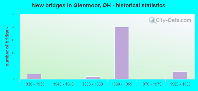
- New bridges - historical statistics
- 21930-1939
- 11950-1959
- 201960-1969
- 31980-1989

- Reconstructed bridges - Historical Statistics
- 31980-1989
- 11990-1999
- 42000-2009
- 12010-2019


- Bridge Condition - Deck
- 25.0%Very good
- 37.5%Good
- 25.0%Satisfactory
- 12.5%Fair

- Bridge Condition - Superstructure
- 6.3%Excellent
- 31.3%Very good
- 43.8%Good
- 12.5%Satisfactory
- 6.3%Fair

- Bridge Condition - Substructure
- 31.3%Very good
- 43.8%Good
- 18.8%Satisfactory
- 6.3%Fair

- Bridge Condition - Channel
- 50.0%Very good
- 25.0%Good
- 25.0%Satisfactory
Find on map >> Show street view
Structure Number: 1500252, Location: 2.18 MI N OF US 30 (Lat: 40.718111, Lng: -80.634989), Route carried "on" structure: State highway 7, Year Built: 1986, Status: Open, Structure Length: 6.10m (20.01ft), Average Daily Traffic: 4,676 (year 2015), Truck Traffic: 11%, Average Future Daily Traffic: 6,490 (year 2035), Design Load: HS 20+Mod, Features Intersected: WEST FORK BEAVER CREEK
Minimum Vertical Clearance: 30+ m (98+ ft), Kilometerpoint: 23.416, Lanes on structure: 2, Base Highway Network: Yes, Owner: State Highway Agency, Approaching Roadway Width: 13.4m (44.0ft), Material/Design: Steel continuous, Design/Construction: Stringer/Multi-beam, Number Of Spans In Main Unit: 3, Length of Maximum Span: 23.2m (76.1ft), Curb-To-Curb Width: 13.4m (44.0ft), Out-to-Out Width: 13.8m (45.3ft)
Condition: Deck: Good, Superstructure: Good, Substructure: Good, Channel: Very good, Operating Rating: 42.1 metric tons, Method Used To Determine Operating Rating: Allowable Stress (AS) rating reported by rating factor (RF) method using MS18 loading, Inventory Rating: 32.4 metric tons, Method Used To Determine Inventory Rating: Allowable Stress (AS) rating reported by rating factor (RF) method using MS18 loading, Structural Evaluation: Better than present minimum criteria, Deck Geometry: Better than present minimum criteria, Waterway Adequacy: Superior to present desirable criteria, Approach Roadway Alignment: Superior to present desirable criteria, Designated Inspection Frequency: Every 24 months, Inspection Date: June 2021, Deck Structure Type: Concrete Cast-file-Place, Wearing Surface/Protective System: Wearing Surface: Monolithic Concrete, Deck Protection: Epoxy Coated Reinforcing
Find on map >> Show street view
Structure Number: 1500279, Location: 2.51 MI N OF US 30 (Lat: 40.722611, Lng: -80.634411), Route carried "on" structure: State highway 7, Year Built: 1960, Year Reconstructed: 2000, Status: Open, Structure Length: 5.21m (17.09ft), Average Daily Traffic: 4,676 (year 2015), Truck Traffic: 11%, Average Future Daily Traffic: 6,490 (year 2035), Design Load: HS 20, Features Intersected: MIDDLE FK LI'L BEAVER CR
Minimum Vertical Clearance: 30+ m (98+ ft), Kilometerpoint: 23.931, Lanes on structure: 2, Base Highway Network: Yes, Owner: State Highway Agency, Approaching Roadway Width: 13.4m (44.0ft), Skew: 1 degrees, Material/Design: Steel continuous, Design/Construction: Stringer/Multi-beam, Number Of Spans In Main Unit: 3, Length of Maximum Span: 19.8m (65.0ft), Curb-To-Curb Width: 13.4m (44.0ft), Out-to-Out Width: 13.4m (44.0ft)
Condition: Deck: Good, Superstructure: Very good, Substructure: Good, Channel: Good, Operating Rating: 42.1 metric tons, Method Used To Determine Operating Rating: Allowable Stress (AS) rating reported by rating factor (RF) method using MS18 loading, Inventory Rating: 32.4 metric tons, Method Used To Determine Inventory Rating: Allowable Stress (AS) rating reported by rating factor (RF) method using MS18 loading, Structural Evaluation: Better than present minimum criteria, Deck Geometry: Better than present minimum criteria, Waterway Adequacy: Equal to present desirable criteria, Approach Roadway Alignment: Equal to present desirable criteria, Designated Inspection Frequency: Every 24 months, Inspection Date: June 2021, Deck Structure Type: Concrete Cast-file-Place, Wearing Surface/Protective System: Wearing Surface: Monolithic Concrete, Deck Protection: Epoxy Coated Reinforcing
Find on map >> Show street view
Structure Number: 1501895, Location: .63 MI E OF SR 11 (Lat: 40.704069, Lng: -80.677011), Route carried "on" structure: US 30, Year Built: 1968, Status: Open, Structure Length: 3.61m (11.84ft), Average Daily Traffic: 6,959 (year 2018), Truck Traffic: 10%, Average Future Daily Traffic: 9,659 (year 2038), Design Load: HS 20, Features Intersected: TWP RD 915
Minimum Vertical Clearance: 30+ m (98+ ft), Kilometerpoint: 41.489, Lanes on structure: 2, Lanes under structure: 2, Base Highway Network: Yes, Owner: State Highway Agency, Approaching Roadway Width: 19.5m (64.0ft), Skew: 1 degrees, Material/Design: Concrete continuous, Design/Construction: Slab, Number Of Spans In Main Unit: 3, Length of Maximum Span: 13.7m (44.9ft), Curb-To-Curb Width: 11.6m (38.1ft), Out-to-Out Width: 12.9m (42.3ft)
Condition: Deck: Satisfactory, Superstructure: Satisfactory, Substructure: Good, Operating Rating: 42.1 metric tons, Method Used To Determine Operating Rating: Load Factor (LF) rating reported by rating factor (RF) method using MS18 loading, Inventory Rating: 32.4 metric tons, Method Used To Determine Inventory Rating: Load Factor (LF) rating reported by rating factor (RF) method using MS18 loading, Structural Evaluation: Equal to present minimum criteria, Deck Geometry: Better than present minimum criteria, Underclear: Equal to present minimum criteria, Approach Roadway Alignment: Equal to present desirable criteria, Designated Inspection Frequency: Every 12 months, Inspection Date: April 2021, Deck Structure Type: Concrete Cast-file-Place, Wearing Surface/Protective System: Wearing Surface: Bituminous
Find on map >> Show street view
Structure Number: 1501925, Location: .63 MI E OF SR 11 (Lat: 40.703839, Lng: -80.677100), Route carried "on" structure: US 30, Year Built: 1968, Status: Open, Structure Length: 3.23m (10.60ft), Average Daily Traffic: 6,959 (year 2018), Truck Traffic: 10%, Average Future Daily Traffic: 9,659 (year 2038), Design Load: HS 20, Features Intersected: TWP RD 915
Minimum Vertical Clearance: 30+ m (98+ ft), Kilometerpoint: 41.489, Lanes on structure: 2, Lanes under structure: 2, Base Highway Network: Yes, Owner: State Highway Agency, Approaching Roadway Width: 19.5m (64.0ft), Skew: 1 degrees, Material/Design: Concrete continuous, Design/Construction: Slab, Number Of Spans In Main Unit: 3, Length of Maximum Span: 12.2m (40.0ft), Curb-To-Curb Width: 11.6m (38.1ft), Out-to-Out Width: 12.9m (42.3ft)
Condition: Deck: Satisfactory, Superstructure: Satisfactory, Substructure: Good, Operating Rating: 35.6 metric tons, Method Used To Determine Operating Rating: Load and Resistance Factor Rating (LRFR) rating reported by rating factor(RF) method using HL-93 loadings, Inventory Rating: 29.2 metric tons, Method Used To Determine Inventory Rating: Load and Resistance Factor Rating (LRFR) rating reported by rating factor(RF) method using HL-93 loadings, Structural Evaluation: Equal to present minimum criteria, Deck Geometry: Better than present minimum criteria, Underclear: Equal to present minimum criteria, Approach Roadway Alignment: Equal to present desirable criteria, Designated Inspection Frequency: Every 12 months, Inspection Date: April 2021, Deck Structure Type: Concrete Cast-file-Place, Wearing Surface/Protective System: Wearing Surface: Bituminous
Find on map >> Show street view
Structure Number: 1501984, Location: 1.55 MI E OF SR 11 (Lat: 40.695181, Lng: -80.664761), Route carried "on" structure: US 30, Year Built: 1969, Year Reconstructed: 2012, Status: Open, Structure Length: 5.39m (17.68ft), Average Daily Traffic: 6,959 (year 2018), Truck Traffic: 10%, Average Future Daily Traffic: 9,659 (year 2038), Design Load: HS 20, Features Intersected: CO ROAD 424
Minimum Vertical Clearance: 30+ m (98+ ft), Kilometerpoint: 42.969, Lanes on structure: 2, Lanes under structure: 2, Base Highway Network: Yes, Owner: State Highway Agency, Approaching Roadway Width: 19.5m (64.0ft), Skew: 5 degrees, Material/Design: Steel continuous, Design/Construction: Stringer/Multi-beam, Number Of Spans In Main Unit: 3, Length of Maximum Span: 19.8m (65.0ft), Curb-To-Curb Width: 11.6m (38.1ft), Out-to-Out Width: 13.1m (43.0ft)
Condition: Deck: Good, Superstructure: Very good, Substructure: Very good, Operating Rating: 87.5 metric tons, Method Used To Determine Operating Rating: Allowable Stress (AS) rating reported by rating factor (RF) method using MS18 loading, Inventory Rating: 51.8 metric tons, Method Used To Determine Inventory Rating: Allowable Stress (AS) rating reported by rating factor (RF) method using MS18 loading, Structural Evaluation: Equal to present desirable criteria, Deck Geometry: Better than present minimum criteria, Underclear: Meets minimum limits, Approach Roadway Alignment: Equal to present desirable criteria, Length Of Structure Improvement: 5.27m (17.29ft), Designated Inspection Frequency: Every 24 months, Inspection Date: April 2021, Roadway Improvement Cost: $25,000, Total Project Cost: $475,000, Deck Structure Type: Concrete Cast-file-Place, Wearing Surface/Protective System: Wearing Surface: Monolithic Concrete, Deck Protection: Epoxy Coated Reinforcing
Find on map >> Show street view
Structure Number: 1502018, Location: 1.55 MI E OF SR 11 (Lat: 40.694819, Lng: -80.664811), Route carried "on" structure: US 30, Year Built: 1969, Year Reconstructed: 2011, Status: Open, Structure Length: 5.39m (17.68ft), Average Daily Traffic: 6,959 (year 2018), Truck Traffic: 10%, Average Future Daily Traffic: 9,659 (year 2038), Design Load: HS 20, Features Intersected: CO ROAD 424, Facility Carried by Structure: US 20
Minimum Vertical Clearance: 30+ m (98+ ft), Kilometerpoint: 42.969, Lanes on structure: 2, Lanes under structure: 2, Base Highway Network: Yes, Owner: State Highway Agency, Approaching Roadway Width: 19.5m (64.0ft), Skew: 5 degrees, Material/Design: Steel continuous, Design/Construction: Stringer/Multi-beam, Number Of Spans In Main Unit: 3, Length of Maximum Span: 19.8m (65.0ft), Curb-To-Curb Width: 12.2m (40.0ft), Out-to-Out Width: 13.1m (43.0ft)
Condition: Deck: Good, Superstructure: Very good, Substructure: Very good, Operating Rating: 42.1 metric tons, Method Used To Determine Operating Rating: Allowable Stress (AS) rating reported by rating factor (RF) method using MS18 loading, Inventory Rating: 32.4 metric tons, Method Used To Determine Inventory Rating: Allowable Stress (AS) rating reported by rating factor (RF) method using MS18 loading, Structural Evaluation: Equal to present desirable criteria, Deck Geometry: Better than present minimum criteria, Underclear: Meets minimum limits, Approach Roadway Alignment: Equal to present desirable criteria, Designated Inspection Frequency: Every 24 months, Inspection Date: April 2021, Deck Structure Type: Concrete Cast-file-Place, Wearing Surface/Protective System: Wearing Surface: Monolithic Concrete, Deck Protection: Epoxy Coated Reinforcing
Find on map >> Show street view
Structure Number: 1502042, Location: .42 MI W OF SR 267 (Lat: 40.685711, Lng: -80.642211), Route carried "on" structure: County highway 451, Year Built: 1967, Year Reconstructed: 1985, Status: Open, Structure Length: 8.90m (29.20ft), Average Daily Traffic: 797 (year 2018), Truck Traffic: 8%, Average Future Daily Traffic: 1,106 (year 2038), Design Load: H 20, Features Intersected: USR-30
Minimum Vertical Clearance: 30+ m (98+ ft), Kilometerpoint: 0.906, Lanes on structure: 2, Lanes under structure: 4, Owner: State Highway Agency, Approaching Roadway Width: 9.8m (32.2ft), Skew: 3 degrees, Material/Design: Steel continuous, Design/Construction: Stringer/Multi-beam, Number Of Spans In Main Unit: 4, Length of Maximum Span: 25.9m (85.0ft), Curb-To-Curb Width: 8.6m (28.2ft), Out-to-Out Width: 9.2m (30.2ft)
Condition: Deck: Satisfactory, Superstructure: Good, Substructure: Good, Operating Rating: 42.1 metric tons, Method Used To Determine Operating Rating: Load Factor (LF) rating reported by rating factor (RF) method using MS18 loading, Inventory Rating: 25.9 metric tons, Method Used To Determine Inventory Rating: Load Factor (LF) rating reported by rating factor (RF) method using MS18 loading, Structural Evaluation: Equal to present minimum criteria, Deck Geometry: Somewhat better than minimum adequacy, Underclear: High priority of corrective action, Approach Roadway Alignment: Equal to present desirable criteria, Designated Inspection Frequency: Every 12 months, Inspection Date: April 2021, Deck Structure Type: Concrete Cast-file-Place, Wearing Surface/Protective System: Wearing Surface: Monolithic Concrete, Deck Protection: Epoxy Coated Reinforcing
Find on map >> Show street view
Structure Number: 1502107, Location: 1.5U MI W OF SR 170 (Lat: 40.674889, Lng: -80.621689), Route carried "on" structure: US 30, Year Built: 1967, Status: Open, Structure Length: 0.98m (3.22ft), Average Daily Traffic: 13,918 (year 2018), Truck Traffic: 10%, Average Future Daily Traffic: 19,318 (year 2038), Design Load: H 20, Features Intersected: LONGS RUN
Minimum Vertical Clearance: 30+ m (98+ ft), Kilometerpoint: 47.347, Lanes on structure: 4, Base Highway Network: Yes, Owner: State Highway Agency, Approaching Roadway Width: 22.6m (74.1ft), Skew: 2 degrees, Material/Design: Steel, Design/Construction: Culvert, Number Of Spans In Main Unit: 2, Length of Maximum Span: 4.3m (14.1ft)
Condition: Channel: Satisfactory, Culverts: Satisfactory, Operating Rating: 97.2 metric tons, Method Used To Determine Operating Rating: Load Factor (LF) rating reported by rating factor (RF) method using MS18 loading, Inventory Rating: 68.0 metric tons, Method Used To Determine Inventory Rating: Load Factor (LF) rating reported by rating factor (RF) method using MS18 loading, Structural Evaluation: Equal to present minimum criteria, Waterway Adequacy: Equal to present desirable criteria, Approach Roadway Alignment: Equal to present desirable criteria, Designated Inspection Frequency: Every 12 months, Inspection Date: April 2021
Find on map >> Show street view
Structure Number: 1502166, Location: 1 MI W OF SR 170 (Lat: 40.673139, Lng: -80.609739), Route carried "on" structure: County highway 963, Year Built: 1967, Status: Open, Structure Length: 5.30m (17.39ft), Average Daily Traffic: 1,300 (year 2015), Truck Traffic: 5%, Average Future Daily Traffic: 1,509 (year 2035), Design Load: H 15, Features Intersected: US 30
Minimum Vertical Clearance: 30+ m (98+ ft), Kilometerpoint: 4.394, Lanes on structure: 2, Lanes under structure: 4, Owner: State Highway Agency, Approaching Roadway Width: 22.6m (74.1ft), Skew: 1 degrees, Material/Design: Steel continuous, Design/Construction: Stringer/Multi-beam, Number Of Spans In Main Unit: 4, Length of Maximum Span: 14.6m (47.9ft), Curb or Sidewalk Widths: Left: 0.5m (1.6ft), Right: 0.5m (1.6ft), Curb-To-Curb Width: 7.3m (24.0ft), Out-to-Out Width: 9.2m (30.2ft)
Condition: Deck: Good, Superstructure: Good, Substructure: Good, Operating Rating: 42.1 metric tons, Method Used To Determine Operating Rating: Load Factor (LF) rating reported by rating factor (RF) method using MS18 loading, Inventory Rating: 29.2 metric tons, Method Used To Determine Inventory Rating: Load Factor (LF) rating reported by rating factor (RF) method using MS18 loading, Structural Evaluation: Better than present minimum criteria, Deck Geometry: Meets minimum limits, Underclear: High priority of corrective action, Approach Roadway Alignment: Equal to present desirable criteria, Designated Inspection Frequency: Every 24 months, Inspection Date: March 2021, Deck Structure Type: Concrete Cast-file-Place, Wearing Surface/Protective System: Wearing Surface: Integral Concrete
Find on map >> Show street view
Structure Number: 1502255, Location: .68 MI E OF SR 170 (Lat: 40.655861, Lng: -80.588289), Route carried "on" structure: US 30, Year Built: 1964, Year Reconstructed: 1985, Status: Open, Structure Length: 4.10m (13.45ft), Average Daily Traffic: 20,444 (year 2015), Truck Traffic: 10%, Average Future Daily Traffic: 28,376 (year 2035), Design Load: HS 20, Features Intersected: HILL AVE TWP RD 1082
Minimum Vertical Clearance: 30+ m (98+ ft), Kilometerpoint: 51.209, Lanes on structure: 4, Lanes under structure: 2, Base Highway Network: Yes, Owner: State Highway Agency, Approaching Roadway Width: 26.8m (87.9ft), Skew: 30 degrees, Material/Design: Steel continuous, Design/Construction: Stringer/Multi-beam, Number Of Spans In Main Unit: 3, Length of Maximum Span: 15.2m (49.9ft), Curb-To-Curb Width: 24.0m (78.7ft), Out-to-Out Width: 26.1m (85.6ft)
Condition: Deck: Fair, Superstructure: Good, Substructure: Fair, Operating Rating: 42.1 metric tons, Method Used To Determine Operating Rating: Allowable Stress (AS) rating reported by rating factor (RF) method using MS18 loading, Inventory Rating: 32.4 metric tons, Method Used To Determine Inventory Rating: Allowable Stress (AS) rating reported by rating factor (RF) method using MS18 loading, Structural Evaluation: Somewhat better than minimum adequacy, Deck Geometry: Superior to present desirable criteria, Underclear: Equal to present minimum criteria, Approach Roadway Alignment: Equal to present desirable criteria, Designated Inspection Frequency: Every 12 months, Inspection Date: March 2021, Deck Structure Type: Concrete Cast-file-Place, Wearing Surface/Protective System: Wearing Surface: Integral Concrete
Find on map >> Show street view
Structure Number: 150432, Location: AT INTERCHANGE W/ US30 (Lat: 40.665131, Lng: -80.592289), Route carried "on" structure: State highway 170, Year Built: 1964, Year Reconstructed: 2002, Status: Open, Structure Length: 5.33m (17.49ft), Average Daily Traffic: 12,761 (year 2015), Truck Traffic: 9%, Average Future Daily Traffic: 17,712 (year 2035), Design Load: HS 20+Mod, Features Intersected: OVER US30 & SR7
Minimum Vertical Clearance: 30+ m (98+ ft), Kilometerpoint: 0.402, Lanes on structure: 4, Lanes under structure: 4, Owner: State Highway Agency, Approaching Roadway Width: 20.7m (67.9ft), Skew: 22 degrees, Material/Design: Steel continuous, Design/Construction: Stringer/Multi-beam, Number Of Spans In Main Unit: 4, Length of Maximum Span: 15.2m (49.9ft), Curb-To-Curb Width: 22.3m (73.2ft), Out-to-Out Width: 23.3m (76.4ft)
Condition: Deck: Satisfactory, Superstructure: Good, Substructure: Satisfactory, Operating Rating: 42.1 metric tons, Method Used To Determine Operating Rating: Allowable Stress (AS) rating reported by rating factor (RF) method using MS18 loading, Inventory Rating: 32.4 metric tons, Method Used To Determine Inventory Rating: Allowable Stress (AS) rating reported by rating factor (RF) method using MS18 loading, Structural Evaluation: Equal to present minimum criteria, Deck Geometry: Superior to present desirable criteria, Underclear: High priority of corrective action, Approach Roadway Alignment: Equal to present minimum criteria, Designated Inspection Frequency: Every 12 months, Inspection Date: March 2021, Deck Structure Type: Concrete Cast-file-Place, Wearing Surface/Protective System: Wearing Surface: Monolithic Concrete, Deck Protection: Epoxy Coated Reinforcing
Find on map >> Show street view
Structure Number: 1504843, Location: .86 MI W OF SR 7 (Lat: 40.672711, Lng: -80.628350), Route carried "on" structure: State highway 267, Year Built: 1986, Status: Open, Structure Length: 1.46m (4.79ft), Average Daily Traffic: 2,346 (year 2018), Truck Traffic: 10%, Average Future Daily Traffic: 3,256 (year 2038), Design Load: HS 20+Mod, Features Intersected: LONGS RUN
Minimum Vertical Clearance: 30+ m (98+ ft), Kilometerpoint: 7.145, Lanes on structure: 2, Owner: State Highway Agency, Approaching Roadway Width: 11.0m (36.1ft), Skew: 4 degrees, Material/Design: Concrete, Design/Construction: Slab, Number Of Spans In Main Unit: 1, Length of Maximum Span: 13.7m (44.9ft), Curb-To-Curb Width: 11.0m (36.1ft), Out-to-Out Width: 11.4m (37.4ft)
Condition: Deck: Fair, Superstructure: Fair, Substructure: Satisfactory, Channel: Satisfactory, Operating Rating: 42.1 metric tons, Method Used To Determine Operating Rating: Load Factor (LF) rating reported by rating factor (RF) method using MS18 loading, Inventory Rating: 32.4 metric tons, Method Used To Determine Inventory Rating: Load Factor (LF) rating reported by rating factor (RF) method using MS18 loading, Structural Evaluation: Somewhat better than minimum adequacy, Deck Geometry: Somewhat better than minimum adequacy, Waterway Adequacy: Equal to present desirable criteria, Approach Roadway Alignment: Better than present minimum criteria, Designated Inspection Frequency: Every 12 months, Inspection Date: April 2021, Deck Structure Type: Concrete Cast-file-Place, Wearing Surface/Protective System: Wearing Surface: Monolithic Concrete, Deck Protection: Epoxy Coated Reinforcing
Find on map >> Show street view
Structure Number: 1504894, Location: .09 MI W OF SR 7 (Lat: 40.682489, Lng: -80.635661), Route carried "on" structure: State highway 267, Year Built: 1967, Year Reconstructed: 2014, Status: Open, Structure Length: 4.86m (15.94ft), Average Daily Traffic: 4,000 (year 2011), Truck Traffic: 6%, Average Future Daily Traffic: 5,552 (year 2031), Design Load: HS 20, Features Intersected: OVER US 30
Minimum Vertical Clearance: 30+ m (98+ ft), Kilometerpoint: 8.530, Lanes on structure: 2, Lanes under structure: 4, Owner: State Highway Agency, Approaching Roadway Width: 13.4m (44.0ft), Material/Design: Steel continuous, Design/Construction: Stringer/Multi-beam, Number Of Spans In Main Unit: 4, Length of Maximum Span: 13.9m (45.6ft), Curb-To-Curb Width: 13.1m (43.0ft), Out-to-Out Width: 14.0m (45.9ft)
Condition: Deck: Very good, Superstructure: Excellent, Substructure: Very good, Operating Rating: 97.2 metric tons, Method Used To Determine Operating Rating: Load Factor (LF) rating reported by rating factor (RF) method using MS18 loading, Inventory Rating: 55.1 metric tons, Method Used To Determine Inventory Rating: Load Factor (LF) rating reported by rating factor (RF) method using MS18 loading, Structural Evaluation: Equal to present desirable criteria, Deck Geometry: Equal to present minimum criteria, Underclear: High priority of corrective action, Approach Roadway Alignment: Equal to present desirable criteria, Designated Inspection Frequency: Every 24 months, Inspection Date: April 2021, Deck Structure Type: Concrete Cast-file-Place, Wearing Surface/Protective System: Wearing Surface: Monolithic Concrete, Deck Protection: Epoxy Coated Reinforcing
Find on map >> Show street view
Structure Number: 1532812, Location: 0.6 MI S C429 (Lat: 40.662039, Lng: -80.647761), Route carried "on" structure: County highway C0424, Year Built: 1939, Year Reconstructed: 1994, Status: Open, Structure Length: 1.16m (3.81ft), Average Daily Traffic: 711 (year 2015), Truck Traffic: 5%, Average Future Daily Traffic: 987 (year 2035), Design Load: HS 20, Features Intersected: NO NAME STREAM, Facility Carried by Structure: Y & O RD 424
Minimum Vertical Clearance: 30+ m (98+ ft), Kilometerpoint: 1.947, Lanes on structure: 2, Owner: County Highway Agency, Approaching Roadway Width: 9.1m (29.9ft), Material/Design: Prestressed concrete, Design/Construction: Box Beam or Girders - Multiple, Number Of Spans In Main Unit: 1, Length of Maximum Span: 11.3m (37.1ft), Curb-To-Curb Width: 9.1m (29.9ft), Out-to-Out Width: 9.8m (32.2ft)
Condition: Deck: Very good, Superstructure: Very good, Substructure: Good, Channel: Very good, Operating Rating: 68.0 metric tons, Method Used To Determine Operating Rating: Load Factor (LF) rating reported by rating factor (RF) method using MS18 loading, Inventory Rating: 42.1 metric tons, Method Used To Determine Inventory Rating: Load Factor (LF) rating reported by rating factor (RF) method using MS18 loading, Structural Evaluation: Better than present minimum criteria, Deck Geometry: Equal to present minimum criteria, Waterway Adequacy: Equal to present desirable criteria, Approach Roadway Alignment: Equal to present desirable criteria, Designated Inspection Frequency: Every 24 months, Inspection Date: August 2021, Deck Structure Type: Concrete Cast-file-Place, Wearing Surface/Protective System: Wearing Surface: Bituminous, Membrane: Preformed Fabric, Deck Protection: Epoxy Coated Reinforcing
Find on map >> Show street view
Structure Number: 1537644, Location: 0.4 MI N C425 (Lat: 40.709650, Lng: -80.667081), Route carried "on" structure: County highway T0914, Year Built: 1950, Year Reconstructed: 2018, Status: Open, Structure Length: 3.11m (10.20ft), Average Daily Traffic: 77 (year 2015), Truck Traffic: 6%, Average Future Daily Traffic: 107 (year 2035), Design Load: HS 20, Features Intersected: WEST FORK LITTLE BEAVER, Facility Carried by Structure: Y-CAMP RD 914
Minimum Vertical Clearance: 30+ m (98+ ft), Kilometerpoint: 1.094, Lanes on structure: 1, Owner: County Highway Agency, Approaching Roadway Width: 7.3m (24.0ft), Material/Design: Steel, Design/Construction: Truss - Thru, Number Of Spans In Main Unit: 1, Length of Maximum Span: 30.8m (101.0ft), Curb-To-Curb Width: 5.3m (17.4ft), Out-to-Out Width: 5.3m (17.4ft)
Condition: Deck: Good, Superstructure: Very good, Substructure: Satisfactory, Channel: Good, Operating Rating: 58.3 metric tons, Method Used To Determine Operating Rating: Load Factor (LF) rating reported by rating factor (RF) method using MS18 loading, Inventory Rating: 45.4 metric tons, Method Used To Determine Inventory Rating: Load Factor (LF) rating reported by rating factor (RF) method using MS18 loading, Structural Evaluation: Equal to present minimum criteria, Deck Geometry: High priority of corrective action, Waterway Adequacy: Superior to present desirable criteria, Approach Roadway Alignment: Equal to present desirable criteria, Designated Inspection Frequency: Every 12 months, Critical Feature Inspection Frequency: Every 24 months, Inspection Date: August 2021, Critical Feature Inspection Date: August 2020, Deck Structure Type: Open Grating
Find on map >> Show street view
Structure Number: 1538284, Location: 0.1 MI E C424 (Lat: 40.661989, Lng: -80.645681), Route carried "on" structure: County highway T1061, Year Built: 1939, Status: Open, Structure Length: 1.04m (3.41ft), Average Daily Traffic: 951 (year 2015), Truck Traffic: 5%, Average Future Daily Traffic: 1,320 (year 2035), Features Intersected: NO NAME, Facility Carried by Structure: YEAGER DR 1061
Minimum Vertical Clearance: 30+ m (98+ ft), Kilometerpoint: 2.253, Lanes on structure: 1, Owner: County Highway Agency, Approaching Roadway Width: 6.4m (21.0ft), Material/Design: Concrete, Design/Construction: Tee Beam, Number Of Spans In Main Unit: 1, Length of Maximum Span: 9.8m (32.2ft), Curb-To-Curb Width: 4.6m (15.1ft), Out-to-Out Width: 5.2m (17.1ft)
Condition: Deck: Very good, Superstructure: Good, Substructure: Very good, Channel: Very good, Operating Rating: 71.3 metric tons, Method Used To Determine Operating Rating: Load Factor (LF) rating reported by rating factor (RF) method using MS18 loading, Inventory Rating: 42.1 metric tons, Method Used To Determine Inventory Rating: Load Factor (LF) rating reported by rating factor (RF) method using MS18 loading, Structural Evaluation: Better than present minimum criteria, Deck Geometry: High priority of replacement, Waterway Adequacy: Equal to present desirable criteria, Approach Roadway Alignment: Somewhat better than minimum adequacy, Designated Inspection Frequency: Every 24 months, Inspection Date: August 2021, Deck Structure Type: Concrete Cast-file-Place, Wearing Surface/Protective System: Wearing Surface: Bituminous
Find on map >> Show street view
Structure Number: 1538446, Location: 0.1 MI N C424 (Lat: 40.663711, Lng: -80.639969), Route carried "on" structure: County highway T2611, Year Built: 1981, Status: Open, Structure Length: 1.52m (4.99ft), Average Daily Traffic: 1,295 (year 2015), Truck Traffic: 5%, Average Future Daily Traffic: 1,797 (year 2035), Design Load: H 20, Features Intersected: LONGS RUN, Facility Carried by Structure: ECHO VALLEY 2611
Minimum Vertical Clearance: 30+ m (98+ ft), Kilometerpoint: 4.554, Lanes on structure: 2, Owner: County Highway Agency, Approaching Roadway Width: 9.1m (29.9ft), Material/Design: Steel, Design/Construction: Stringer/Multi-beam, Number Of Spans In Main Unit: 1, Length of Maximum Span: 14.6m (47.9ft), Curb-To-Curb Width: 7.3m (24.0ft), Out-to-Out Width: 7.3m (24.0ft)
Condition: Deck: Very good, Superstructure: Good, Substructure: Very good, Channel: Very good, Operating Rating: 68.0 metric tons, Method Used To Determine Operating Rating: Load Factor (LF) rating reported by rating factor (RF) method using MS18 loading, Inventory Rating: 42.1 metric tons, Method Used To Determine Inventory Rating: Load Factor (LF) rating reported by rating factor (RF) method using MS18 loading, Structural Evaluation: Better than present minimum criteria, Deck Geometry: Meets minimum limits, Waterway Adequacy: Superior to present desirable criteria, Approach Roadway Alignment: Equal to present desirable criteria, Designated Inspection Frequency: Every 24 months, Inspection Date: August 2021, Deck Structure Type: Open Grating
Find on map >> Show street view
Structure Number: 1501895, Location: .63 MI E OF SR 11 (Lat: 40.704069, Lng: -80.677011), Route carried "under" structure: County highway 915, Year Built: 1968, Structure Length: 0. m, Average Daily Traffic: 209 (year 2015), Truck Traffic: 7%, Features Intersected: US 30, Facility Carried by Structure: US 30
Minimum Vertical Clearance: 4.50m (14.76ft), Kilometerpoint: 46.204, Lanes on structure: 2, Lanes under structure: 2, Material/Design: Concrete continuous, Design/Construction: Slab, Length of Maximum Span: 13.7m (44.9ft)
Find on map >> Show street view
Structure Number: 1501925, Location: .63 MI E OF SR 11 (Lat: 40.703839, Lng: -80.677100), Route carried "under" structure: County highway 915, Year Built: 1968, Structure Length: 0. m, Average Daily Traffic: 209 (year 2015), Truck Traffic: 7%, Features Intersected: US 30, Facility Carried by Structure: US 30
Minimum Vertical Clearance: 4.50m (14.76ft), Kilometerpoint: 46.204, Lanes on structure: 2, Lanes under structure: 2, Material/Design: Concrete continuous, Design/Construction: Slab, Length of Maximum Span: 12.2m (40.0ft)
Find on map >> Show street view
Structure Number: 1501984, Location: 1.55 MI E OF SR 11 (Lat: 40.695181, Lng: -80.664761), Route carried "under" structure: County highway 424, Year Built: 1969, Structure Length: 0. m, Average Daily Traffic: 711 (year 2015), Truck Traffic: 7%, Features Intersected: US 30, Facility Carried by Structure: US 30
Minimum Vertical Clearance: 4.47m (14.67ft), Kilometerpoint: 46.050, Lanes on structure: 2, Lanes under structure: 2, Material/Design: Steel continuous, Design/Construction: Stringer/Multi-beam, Length of Maximum Span: 19.8m (65.0ft)
Find on map >> Show street view
Structure Number: 1502018, Location: 1.55 MI E OF SR 11 (Lat: 40.694819, Lng: -80.664811), Route carried "under" structure: County highway 424, Year Built: 1969, Structure Length: 0. m, Average Daily Traffic: 711 (year 2015), Truck Traffic: 7%, Features Intersected: US 30, Facility Carried by Structure: US 20
Minimum Vertical Clearance: 4.47m (14.67ft), Kilometerpoint: 46.050, Lanes on structure: 2, Lanes under structure: 2, Material/Design: Steel continuous, Design/Construction: Stringer/Multi-beam, Length of Maximum Span: 19.8m (65.0ft)
Find on map >> Show street view
Structure Number: 1502042, Location: .42 MI W OF SR 267 (Lat: 40.685711, Lng: -80.642211), Route carried "under" structure: US 30, Year Built: 1967, Structure Length: 0. m, Average Daily Traffic: 12,584 (year 2016), Truck Traffic: 14%, Features Intersected: CR-451 OLD LINCOLN HWY, Facility Carried by Structure: CR-451 OLD LINCOLN
Minimum Vertical Clearance: 4.65m (15.26ft), Kilometerpoint: 45.174, Lanes on structure: 2, Lanes under structure: 4, Material/Design: Steel continuous, Design/Construction: Stringer/Multi-beam, Length of Maximum Span: 25.9m (85.0ft)
Find on map >> Show street view
Structure Number: 1502166, Location: 1 MI W OF SR 170 (Lat: 40.673139, Lng: -80.609739), Route carried "under" structure: US 30, Year Built: 1967, Structure Length: 0. m, Average Daily Traffic: 13,717 (year 2016), Truck Traffic: 21%, Features Intersected: TR-963 ANNESLEY RD, Facility Carried by Structure: TR 963 ANNESLEY RD
Minimum Vertical Clearance: 5.72m (18.77ft), Kilometerpoint: 48.345, Lanes on structure: 2, Lanes under structure: 4, Material/Design: Steel continuous, Design/Construction: Stringer/Multi-beam, Length of Maximum Span: 14.6m (47.9ft)
Find on map >> Show street view
Structure Number: 1502255, Location: .68 MI E OF SR 170 (Lat: 40.655861, Lng: -80.588289), Route carried "under" structure: City street 1082, Year Built: 1964, Structure Length: 0. m, Average Daily Traffic: 2,227 (year 2015), Truck Traffic: 5%, Features Intersected: US 30, Facility Carried by Structure: US 30 & SR 7
Minimum Vertical Clearance: 4.42m (14.50ft), Kilometerpoint: 1.513, Lanes on structure: 4, Lanes under structure: 2, Material/Design: Steel continuous, Design/Construction: Stringer/Multi-beam, Length of Maximum Span: 15.2m (49.9ft)
Find on map >> Show street view
Structure Number: 150432, Location: AT INTERCHANGE W/ US30 (Lat: 40.665131, Lng: -80.592289), Route carried "under" structure: US 30, Year Built: 1964, Structure Length: 0. m, Average Daily Traffic: 20,444 (year 2015), Truck Traffic: 10%, Features Intersected: SR 170, Facility Carried by Structure: SR 170
Minimum Vertical Clearance: 4.67m (15.32ft), Kilometerpoint: 51.515, Lanes on structure: 4, Lanes under structure: 4, Material/Design: Steel continuous, Design/Construction: Stringer/Multi-beam, Length of Maximum Span: 15.2m (49.9ft)
Find on map >> Show street view
Structure Number: 1504894, Location: .09 MI W OF SR 7 (Lat: 40.682489, Lng: -80.635661), Route carried "under" structure: US 30, Year Built: 1967, Structure Length: 0. m, Average Daily Traffic: 13,918 (year 2015), Truck Traffic: 10%, Features Intersected: SR 267, Facility Carried by Structure: SR 267
Minimum Vertical Clearance: 4.98m (16.34ft), Kilometerpoint: 47.266, Lanes on structure: 2, Lanes under structure: 4, Material/Design: Steel continuous, Design/Construction: Stringer/Multi-beam, Length of Maximum Span: 13.9m (45.6ft)