Bridge Statistics for Gilbert, South Carolina (SC)
Condition, Traffic, Stress, Structural Evaluation, Project Costs
- National Bridge Inventory (NBI) Statistics
- 12Number of bridges
- 92ft / 27.6mTotal length
- $176,000Total costs
- 143,625Total average daily traffic
- 25,463Total average daily truck traffic
- National Bridge Inventory (NBI) Registered Bridges for Gilbert
- No street view available for this location
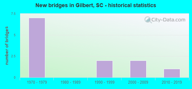
- New bridges - historical statistics
- 71970-1979
- 21990-1999
- 22000-2009
- 12010-2019


- Bridge Condition - Deck
- 50.0%Very good
- 33.3%Good
- 16.7%Satisfactory

- Bridge Condition - Superstructure
- 33.3%Very good
- 33.3%Good
- 33.3%Satisfactory

- Bridge Condition - Substructure
- 33.3%Very good
- 66.7%Satisfactory

- Bridge Condition - Culverts
- 33.3%Very good
- 33.3%Good
- 33.3%Satisfactory
Find on map >> Show street view
Structure Number: 5118, Location: TOWN OF GILBERT (Lat: 33.933953, Lng: -81.389911), Route carried "on" structure: State highway 880, Year Built: 2005, Status: Open, Structure Length: 1.52m (4.99ft), Average Daily Traffic: 125 (year 2020), Truck Traffic: 8%, Average Future Daily Traffic: 243 (year 2040), Design Load: HS 20, Features Intersected: TWELVEMILE CREEK
Minimum Vertical Clearance: 30+ m (98+ ft), Kilometerpoint: 8.866, Lanes on structure: 2, Owner: State Highway Agency, Approaching Roadway Width: 10.1m (33.1ft), Material/Design: Prestressed concrete, Design/Construction: Slab, Number Of Spans In Main Unit: 1, Length of Maximum Span: 15.2m (49.9ft), Curb-To-Curb Width: 10.1m (33.1ft), Out-to-Out Width: 11.0m (36.1ft)
Condition: Deck: Very good, Superstructure: Very good, Substructure: Very good, Channel: Very good, Operating Rating: 45.4 metric tons, Method Used To Determine Operating Rating: Load and Resistance Factor Rating (LRFR) rating reported by rating factor(RF) method using HL-93 loadings, Inventory Rating: 34.3 metric tons, Method Used To Determine Inventory Rating: Load and Resistance Factor Rating (LRFR) rating reported by rating factor(RF) method using HL-93 loadings, Structural Evaluation: Equal to present desirable criteria, Deck Geometry: Better than present minimum criteria, Waterway Adequacy: Better than present minimum criteria, Approach Roadway Alignment: Equal to present desirable criteria, Length Of Structure Improvement: 1.52m (4.99ft), Designated Inspection Frequency: Every 24 months, Inspection Date: September 2020, Deck Structure Type: Concrete Precast Panels, Wearing Surface/Protective System: Wearing Surface: Bituminous
Find on map >> Show street view
Structure Number: 5798, Location: 3MI SE OF GILBERT (Lat: 33.891517, Lng: -81.358189), Route carried "on" structure: Interstate 20, Year Built: 1970, Status: Open, Structure Length: 0.66m (2.17ft), Average Daily Traffic: 36,300 (year 2021), Truck Traffic: 20%, Average Future Daily Traffic: 58,080 (year 2041), Design Load: H 15, Features Intersected: BLACK CREEK
Minimum Vertical Clearance: 30+ m (98+ ft), Kilometerpoint: 74.440, Lanes on structure: 4, Base Highway Network: Yes, Owner: State Highway Agency, Approaching Roadway Width: 42.1m (138.1ft), Skew: 1 degrees, Material/Design: Concrete, Design/Construction: Culvert, Number Of Spans In Main Unit: 2, Length of Maximum Span: 3.0m (9.8ft), Curb-To-Curb Width: 42.1m (138.1ft), Out-to-Out Width: 45.7m (149.9ft)
Condition: Channel: Very good, Culverts: Good, Operating Rating: 78.4 metric tons, Method Used To Determine Operating Rating: Load and Resistance Factor Rating (LRFR) rating reported by rating factor(RF) method using HL-93 loadings, Inventory Rating: 60.6 metric tons, Method Used To Determine Inventory Rating: Load and Resistance Factor Rating (LRFR) rating reported by rating factor(RF) method using HL-93 loadings, Structural Evaluation: Better than present minimum criteria, Deck Geometry: Superior to present desirable criteria, Waterway Adequacy: Equal to present minimum criteria, Approach Roadway Alignment: Equal to present desirable criteria, Length Of Structure Improvement: 0.66m (2.17ft), Designated Inspection Frequency: Every 24 months, Inspection Date: October 2021
Find on map >> Show street view
Structure Number: 58, Location: 8 MI SE LEESVILLE (Lat: 33.871014, Lng: -81.385025), Route carried "on" structure: State highway 34, Year Built: 1970, Status: Open, Structure Length: 9.14m (29.99ft), Average Daily Traffic: 3,700 (year 2020), Truck Traffic: 9%, Average Future Daily Traffic: 5,402 (year 2040), Design Load: HS 20+Mod, Features Intersected: I-20
Minimum Vertical Clearance: 5.13m (16.83ft), Kilometerpoint: 14.072, Lanes on structure: 2, Lanes under structure: 4, Owner: State Highway Agency, Approaching Roadway Width: 13.4m (44.0ft), Skew: 3 degrees, Material/Design: Steel, Design/Construction: Stringer/Multi-beam, Number Of Spans In Main Unit: 4, Length of Maximum Span: 30.8m (101.0ft), Curb-To-Curb Width: 13.4m (44.0ft), Out-to-Out Width: 14.6m (47.9ft)
Condition: Deck: Good, Superstructure: Satisfactory, Substructure: Satisfactory, Operating Rating: 53.1 metric tons, Method Used To Determine Operating Rating: Load and Resistance Factor Rating (LRFR) rating reported by rating factor(RF) method using HL-93 loadings, Inventory Rating: 41.1 metric tons, Method Used To Determine Inventory Rating: Load and Resistance Factor Rating (LRFR) rating reported by rating factor(RF) method using HL-93 loadings, Structural Evaluation: Equal to present minimum criteria, Deck Geometry: Better than present minimum criteria, Underclear: Somewhat better than minimum adequacy, Approach Roadway Alignment: Equal to present desirable criteria, Length Of Structure Improvement: 9.14m (29.99ft), Designated Inspection Frequency: Every 24 months, Inspection Date: November 2020, Deck Structure Type: Concrete Cast-file-Place, Wearing Surface/Protective System: Wearing Surface: Monolithic Concrete
Find on map >> Show street view
Structure Number: 5805, Location: 7 MI SW LEXINGTON (Lat: 33.911503, Lng: -81.325911), Route carried "on" structure: State highway 278, Year Built: 1970, Year Reconstructed: 2017, Status: Open, Structure Length: 10.55m (34.61ft), Average Daily Traffic: 3,200 (year 2020), Truck Traffic: 8%, Average Future Daily Traffic: 6,208 (year 2040), Design Load: HS 15, Features Intersected: I-20
Minimum Vertical Clearance: 30+ m (98+ ft), Kilometerpoint: 6.703, Lanes on structure: 2, Lanes under structure: 4, Owner: State Highway Agency, Approaching Roadway Width: 11.3m (37.1ft), Material/Design: Steel, Design/Construction: Stringer/Multi-beam, Number Of Spans In Main Unit: 5, Length of Maximum Span: 28.3m (92.8ft), Curb-To-Curb Width: 11.4m (37.4ft), Out-to-Out Width: 11.6m (38.1ft)
Condition: Deck: Very good, Superstructure: Good, Substructure: Satisfactory, Operating Rating: 49.6 metric tons, Method Used To Determine Operating Rating: Load and Resistance Factor Rating (LRFR) rating reported by rating factor(RF) method using HL-93 loadings, Inventory Rating: 38.2 metric tons, Method Used To Determine Inventory Rating: Load and Resistance Factor Rating (LRFR) rating reported by rating factor(RF) method using HL-93 loadings, Structural Evaluation: Equal to present minimum criteria, Deck Geometry: Somewhat better than minimum adequacy, Underclear: Equal to present minimum criteria, Approach Roadway Alignment: Equal to present desirable criteria, Length Of Structure Improvement: 10.55m (34.61ft), Designated Inspection Frequency: Every 24 months, Inspection Date: November 2020, Deck Structure Type: Concrete Cast-file-Place, Wearing Surface/Protective System: Wearing Surface: Monolithic Concrete
Find on map >> Show street view
Structure Number: 5807, Location: 3 MI SE OF GILBERT (Lat: 33.891183, Lng: -81.357853), Route carried "on" structure: State highway 774, Year Built: 1970, Status: Open, Structure Length: 0.64m (2.10ft), Average Daily Traffic: 125 (year 2020), Truck Traffic: 5%, Average Future Daily Traffic: 160 (year 2040), Design Load: H 20, Features Intersected: BLACK CREEK
Minimum Vertical Clearance: 30+ m (98+ ft), Kilometerpoint: 17.048, Lanes on structure: 2, Owner: State Highway Agency, Approaching Roadway Width: 8.8m (28.9ft), Material/Design: Concrete, Design/Construction: Culvert, Number Of Spans In Main Unit: 2, Length of Maximum Span: 3.0m (9.8ft), Curb-To-Curb Width: 9.0m (29.5ft), Out-to-Out Width: 15.5m (50.9ft)
Condition: Channel: Very good, Culverts: Satisfactory, Operating Rating: 76.1 metric tons, Method Used To Determine Operating Rating: Load and Resistance Factor Rating (LRFR) rating reported by rating factor(RF) method using HL-93 loadings, Inventory Rating: 58.6 metric tons, Method Used To Determine Inventory Rating: Load and Resistance Factor Rating (LRFR) rating reported by rating factor(RF) method using HL-93 loadings, Structural Evaluation: Equal to present minimum criteria, Deck Geometry: Equal to present minimum criteria, Waterway Adequacy: Better than present minimum criteria, Approach Roadway Alignment: Equal to present desirable criteria, Length Of Structure Improvement: 0.64m (2.10ft), Designated Inspection Frequency: Every 24 months, Inspection Date: September 2020
Find on map >> Show street view
Structure Number: 7138, Location: 2 MI SE OF GILBERT (Lat: 33.895572, Lng: -81.371003), Route carried "on" structure: State highway 37, Year Built: 2005, Status: Open, Structure Length: 1.22m (4.00ft), Average Daily Traffic: 3,500 (year 2020), Truck Traffic: 9%, Average Future Daily Traffic: 5,110 (year 2040), Design Load: HS 25 or greater, Features Intersected: BLACK CREEK
Minimum Vertical Clearance: 30+ m (98+ ft), Kilometerpoint: 4.394, Lanes on structure: 2, Owner: State Highway Agency, Approaching Roadway Width: 10.1m (33.1ft), Material/Design: Prestressed concrete, Design/Construction: Slab, Number Of Spans In Main Unit: 1, Length of Maximum Span: 12.2m (40.0ft), Curb-To-Curb Width: 10.1m (33.1ft), Out-to-Out Width: 11.0m (36.1ft)
Condition: Deck: Very good, Superstructure: Very good, Substructure: Very good, Channel: Very good, Operating Rating: 71.6 metric tons, Method Used To Determine Operating Rating: Load and Resistance Factor Rating (LRFR) rating reported by rating factor(RF) method using HL-93 loadings, Inventory Rating: 55.1 metric tons, Method Used To Determine Inventory Rating: Load and Resistance Factor Rating (LRFR) rating reported by rating factor(RF) method using HL-93 loadings, Structural Evaluation: Equal to present desirable criteria, Deck Geometry: Meets minimum limits, Waterway Adequacy: Better than present minimum criteria, Approach Roadway Alignment: Equal to present desirable criteria, Length Of Structure Improvement: 1.22m (4.00ft), Designated Inspection Frequency: Every 24 months, Inspection Date: September 2020, Deck Structure Type: Concrete Precast Panels, Wearing Surface/Protective System: Wearing Surface: Bituminous
Find on map >> Show street view
Structure Number: 8367, Location: 6 MI SW OF LEXINGTON (Lat: 33.944586, Lng: -81.331508), Route carried "on" structure: State highway 278, Year Built: 1990, Status: Open, Structure Length: 1.83m (6.00ft), Average Daily Traffic: 3,200 (year 2020), Truck Traffic: 8%, Average Future Daily Traffic: 6,208 (year 2040), Design Load: HS 20, Features Intersected: TWELVEMILE CREEK
Minimum Vertical Clearance: 30+ m (98+ ft), Kilometerpoint: 2.897, Lanes on structure: 2, Owner: State Highway Agency, Approaching Roadway Width: 11.9m (39.0ft), Material/Design: Concrete, Design/Construction: Slab, Number Of Spans In Main Unit: 4, Length of Maximum Span: 4.6m (15.1ft), Curb-To-Curb Width: 10.4m (34.1ft), Out-to-Out Width: 11.9m (39.0ft)
Condition: Deck: Satisfactory, Superstructure: Satisfactory, Substructure: Satisfactory, Channel: Very good, Operating Rating: 48.9 metric tons, Method Used To Determine Operating Rating: Load and Resistance Factor Rating (LRFR) rating reported by rating factor(RF) method using HL-93 loadings, Inventory Rating: 37.9 metric tons, Method Used To Determine Inventory Rating: Load and Resistance Factor Rating (LRFR) rating reported by rating factor(RF) method using HL-93 loadings, Structural Evaluation: Equal to present minimum criteria, Deck Geometry: Somewhat better than minimum adequacy, Waterway Adequacy: Better than present minimum criteria, Approach Roadway Alignment: Equal to present desirable criteria, Length Of Structure Improvement: 1.83m (6.00ft), Designated Inspection Frequency: Every 24 months, Inspection Date: September 2020, Deck Structure Type: Concrete Cast-file-Place, Wearing Surface/Protective System: Wearing Surface: Bituminous
Find on map >> Show street view
Structure Number: 8467, Location: 5 MI W LEXINGTON (Lat: 33.951108, Lng: -81.335481), Route carried "on" structure: State highway 604, Year Built: 1991, Status: Open, Structure Length: 1.37m (4.49ft), Average Daily Traffic: 400 (year 2020), Truck Traffic: 5%, Average Future Daily Traffic: 512 (year 2040), Design Load: HS 20, Features Intersected: HOGPEN BRANCH
Minimum Vertical Clearance: 30+ m (98+ ft), Kilometerpoint: 1.194, Lanes on structure: 2, Owner: State Highway Agency, Approaching Roadway Width: 10.4m (34.1ft), Material/Design: Concrete, Design/Construction: Slab, Number Of Spans In Main Unit: 3, Length of Maximum Span: 4.6m (15.1ft), Curb-To-Curb Width: 10.4m (34.1ft), Out-to-Out Width: 11.8m (38.7ft)
Condition: Deck: Good, Superstructure: Good, Substructure: Satisfactory, Channel: Very good, Operating Rating: 48.6 metric tons, Method Used To Determine Operating Rating: Load and Resistance Factor Rating (LRFR) rating reported by rating factor(RF) method using HL-93 loadings, Inventory Rating: 37.6 metric tons, Method Used To Determine Inventory Rating: Load and Resistance Factor Rating (LRFR) rating reported by rating factor(RF) method using HL-93 loadings, Structural Evaluation: Equal to present minimum criteria, Deck Geometry: Better than present minimum criteria, Waterway Adequacy: Better than present minimum criteria, Approach Roadway Alignment: Equal to present desirable criteria, Length Of Structure Improvement: 1.37m (4.49ft), Designated Inspection Frequency: Every 24 months, Inspection Date: September 2020, Deck Structure Type: Concrete Precast Panels, Wearing Surface/Protective System: Wearing Surface: Bituminous
Find on map >> Show street view
Structure Number: 10327, Location: 5 MI NE OF GILBERT (Lat: 33.953917, Lng: -81.350797), Route carried "on" structure: State highway 944, Year Built: 2016, Status: Open, Structure Length: 0.71m (2.33ft), Average Daily Traffic: 275 (year 2021), Truck Traffic: 5%, Average Future Daily Traffic: 352 (year 2041), Design Load: HS 20, Features Intersected: LONGS CREEK
Minimum Vertical Clearance: 30+ m (98+ ft), Kilometerpoint: 0.349, Lanes on structure: 2, Owner: State Highway Agency, Approaching Roadway Width: 9.9m (32.5ft), Material/Design: Concrete, Design/Construction: Culvert, Number Of Spans In Main Unit: 2, Length of Maximum Span: 3.0m (9.8ft), Curb-To-Curb Width: 9.9m (32.5ft), Out-to-Out Width: 13.6m (44.6ft)
Condition: Channel: Very good, Culverts: Very good, Operating Rating: 71.9 metric tons, Method Used To Determine Operating Rating: Load and Resistance Factor Rating (LRFR) rating reported by rating factor(RF) method using HL-93 loadings, Inventory Rating: 71.9 metric tons, Method Used To Determine Inventory Rating: Load and Resistance Factor Rating (LRFR) rating reported by rating factor(RF) method using HL-93 loadings, Structural Evaluation: Equal to present desirable criteria, Deck Geometry: Better than present minimum criteria, Waterway Adequacy: Better than present minimum criteria, Approach Roadway Alignment: Better than present minimum criteria, Bridge Posting: Required (Relationship of Operating Rating to Maximum Legal Load: > 39.9% below), Length Of Structure Improvement: 1.33m (4.36ft), Designated Inspection Frequency: Every 24 months, Inspection Date: September 2020, Bridge Improvement Cost: $117,000, Roadway Improvement Cost: $29,000, Total Project Cost: $176,000 ( Estimate for 2022), Deck Structure Type: Concrete Precast Panels, Wearing Surface/Protective System: Wearing Surface: Monolithic Concrete
Find on map >> Show street view
Structure Number: 58, Location: 8 MI SE LEESVILLE (Lat: 33.871014, Lng: -81.385025), Route carried "under" structure: Interstate 20, Year Built: 1970, Structure Length: 0. m, Average Daily Traffic: 29,000 (year 2020), Truck Traffic: 19%, Features Intersected: I-20, Facility Carried by Structure: S-32-34
Minimum Vertical Clearance: 5.13m (16.83ft), Kilometerpoint: 71.117, Lanes on structure: 2, Lanes under structure: 4, Material/Design: Steel, Design/Construction: Stringer/Multi-beam, Length of Maximum Span: 30.8m (101.0ft)
Find on map >> Show street view
Structure Number: 5805, Location: 7 MI SW LEXINGTON (Lat: 33.911503, Lng: -81.325911), Route carried "under" structure: Interstate 20, Year Built: 1970, Structure Length: 0. m, Average Daily Traffic: 31,900 (year 2020), Truck Traffic: 18%, Features Intersected: I-20, Facility Carried by Structure: S-32-278
Minimum Vertical Clearance: 6.27m (20.57ft), Kilometerpoint: 78.262, Lanes on structure: 2, Lanes under structure: 4, Material/Design: Steel, Design/Construction: Stringer/Multi-beam, Length of Maximum Span: 28.3m (92.8ft)
Find on map >> Show street view
Structure Number: 5806, Location: 3 MI SE OF GILBERT (Lat: 33.893433, Lng: -81.355325), Route carried "under" structure: Interstate 20, Year Built: 1970, Structure Length: 0. m, Average Daily Traffic: 31,900 (year 2020), Truck Traffic: 18%, Features Intersected: I-20, Facility Carried by Structure: S-32-625
Minimum Vertical Clearance: 5.28m (17.32ft), Kilometerpoint: 74.867, Lanes on structure: 2, Lanes under structure: 4, Material/Design: Steel, Design/Construction: Stringer/Multi-beam, Length of Maximum Span: 26.2m (86.0ft)