Bridge Statistics for Garden View, Pennsylvania (PA)
Condition, Traffic, Stress, Structural Evaluation, Project Costs
- National Bridge Inventory (NBI) Statistics
- 37Number of bridges
- 236ft / 72.2mTotal length
- $4,192,000Total costs
- 223,547Total average daily traffic
- 31,168Total average daily truck traffic
- National Bridge Inventory (NBI) Registered Bridges for Garden View
- No street view available for this location
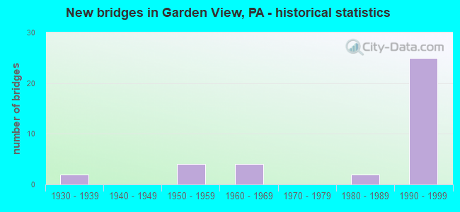
- New bridges - historical statistics
- 21930-1939
- 41950-1959
- 41960-1969
- 21980-1989
- 251990-1999

- Reconstructed bridges - Historical Statistics
- 11940-1949
- 01950-1959
- 01960-1969
- 11970-1979
- 11980-1989
- 01990-1999
- 22000-2009
- 12010-2019


- Bridge Condition - Deck
- 4.5%Very good
- 63.6%Good
- 27.3%Satisfactory
- 4.5%Fair

- Bridge Condition - Superstructure
- 13.6%Very good
- 68.2%Good
- 9.1%Satisfactory
- 9.1%Fair

- Bridge Condition - Substructure
- 72.7%Good
- 4.5%Satisfactory
- 18.2%Fair
- 4.5%Poor

- Bridge Condition - Channel
- 33.3%Good
- 20.0%Satisfactory
- 46.7%Fair
Find on map >> Show street view
Structure Number: 24539, Location: 2.5 MI N OF WILLIAMSPORT (Lat: 41.261375, Lng: -77.044094), Route carried "on" structure: State highway , Year Built: 1954, Year Reconstructed: 2005, Status: Open, Structure Length: 1.95m (6.40ft), Average Daily Traffic: 10,168 (year 2020), Truck Traffic: 6%, Average Future Daily Traffic: 11,623 (year 2032), Design Load: HL 93, Features Intersected: BOTTLE RUN, Facility Carried by Structure: JOHN GROSS MEM BR
Minimum Vertical Clearance: 30+ m (98+ ft), Kilometerpoint: 0.278, Lanes on structure: 4, Owner: State Highway Agency, Approaching Roadway Width: 14.6m (47.9ft), Material/Design: Steel, Design/Construction: Stringer/Multi-beam, Number Of Spans In Main Unit: 1, Length of Maximum Span: 18.6m (61.0ft), Curb or Sidewalk Widths: Left: 1.6m (5.2ft), Right: 1.6m (5.2ft), Curb-To-Curb Width: 19.0m (62.3ft), Out-to-Out Width: 22.8m (74.8ft)
Condition: Deck: Good, Superstructure: Satisfactory, Substructure: Satisfactory, Channel: Good, Operating Rating: 68.9 metric tons, Method Used To Determine Operating Rating: Load and Resistance Factor (LRFR), Inventory Rating: 52.6 metric tons, Method Used To Determine Inventory Rating: Load and Resistance Factor (LRFR), Structural Evaluation: Equal to present minimum criteria, Deck Geometry: Equal to present minimum criteria, Waterway Adequacy: Equal to present minimum criteria, Approach Roadway Alignment: Equal to present desirable criteria, Length Of Structure Improvement: 2.00m (6.56ft), Designated Inspection Frequency: Every 48 months, Inspection Date: December 2019, Bridge Improvement Cost: $81,000, Roadway Improvement Cost: $237,000, Total Project Cost: $1,088,000, Deck Structure Type: Concrete Cast-file-Place, Wearing Surface/Protective System: Wearing Surface: Epoxy Overlay, Deck Protection: Epoxy Coated Reinforcing
Find on map >> Show street view
Structure Number: 2454, Location: 3 MI N OF WILLIAMSPORT (Lat: 41.267492, Lng: -77.047636), Route carried "on" structure: State highway , Year Built: 1957, Year Reconstructed: 1984, Status: Open, Structure Length: 8.32m (27.30ft), Average Daily Traffic: 5,775 (year 2022), Truck Traffic: 6%, Average Future Daily Traffic: 11,623 (year 2032), Design Load: HS 20+Mod, Features Intersected: OVER LYCOMING CREEK, Facility Carried by Structure: SR 1017 #2 LYC CK
Minimum Vertical Clearance: 30+ m (98+ ft), Kilometerpoint: 1.184, Lanes on structure: 4, Owner: State Highway Agency, Approaching Roadway Width: 18.3m (60.0ft), Skew: 23 degrees, Material/Design: Steel continuous, Design/Construction: Stringer/Multi-beam, Number Of Spans In Main Unit: 4, Length of Maximum Span: 21.9m (71.9ft), Curb or Sidewalk Widths: Left: 0.2m (0.7ft), Right: 1.6m (5.2ft), Curb-To-Curb Width: 18.6m (61.0ft), Out-to-Out Width: 21.0m (68.9ft)
Condition: Deck: Satisfactory, Superstructure: Good, Substructure: Fair, Channel: Fair, Operating Rating: 70.8 metric tons, Method Used To Determine Operating Rating: Load Factor (LF), Inventory Rating: 42.6 metric tons, Method Used To Determine Inventory Rating: Load Factor (LF), Structural Evaluation: Somewhat better than minimum adequacy, Deck Geometry: Equal to present minimum criteria, Waterway Adequacy: Equal to present minimum criteria, Approach Roadway Alignment: Equal to present desirable criteria, Length Of Structure Improvement: 8.30m (27.23ft), Designated Inspection Frequency: Every 24 months, Underwater Inspection Frequency: Every 48 months, Inspection Date: June 2020, Underwater Inspection Date: June 2020, Deck Structure Type: Concrete Cast-file-Place, Wearing Surface/Protective System: Wearing Surface: Monolithic Concrete, Deck Protection: Epoxy Coated Reinforcing
Find on map >> Show street view
Structure Number: 24541, Location: 0.5 MI S OF HEPBURNVILLE (Lat: 41.287372, Lng: -77.055333), Route carried "on" structure: State highway , Year Built: 1967, Year Reconstructed: 1988, Status: Open, Structure Length: 7.62m (25.00ft), Average Daily Traffic: 5,775 (year 2022), Truck Traffic: 6%, Average Future Daily Traffic: 11,623 (year 2032), Design Load: HS 25 or greater, Features Intersected: OVER LYCOMING CREEK, Facility Carried by Structure: SR 1017 #3 LYC CK.
Minimum Vertical Clearance: 30+ m (98+ ft), Kilometerpoint: 3.819, Lanes on structure: 4, Owner: State Highway Agency, Approaching Roadway Width: 16.8m (55.1ft), Skew: 3 degrees, Material/Design: Steel continuous, Design/Construction: Stringer/Multi-beam, Number Of Spans In Main Unit: 3, Length of Maximum Span: 28.3m (92.8ft), Curb or Sidewalk Widths: Left: 1.5m (4.9ft), Right: 1.5m (4.9ft), Curb-To-Curb Width: 16.5m (54.1ft), Out-to-Out Width: 20.9m (68.6ft)
Condition: Deck: Good, Superstructure: Good, Substructure: Fair, Channel: Satisfactory, Operating Rating: 59.9 metric tons, Method Used To Determine Operating Rating: Load Factor (LF), Inventory Rating: 36.3 metric tons, Method Used To Determine Inventory Rating: Load Factor (LF), Structural Evaluation: Somewhat better than minimum adequacy, Deck Geometry: Meets minimum limits, Waterway Adequacy: Equal to present desirable criteria, Approach Roadway Alignment: Equal to present desirable criteria, Length Of Structure Improvement: 7.60m (24.93ft), Designated Inspection Frequency: Every 24 months, Underwater Inspection Frequency: Every 24 months, Inspection Date: June 2020, Underwater Inspection Date: June 2020, Bridge Improvement Cost: $115,000, Roadway Improvement Cost: $338,000, Total Project Cost: $1,551,000, Deck Structure Type: Concrete Cast-file-Place, Wearing Surface/Protective System: Wearing Surface: Monolithic Concrete, Deck Protection: Epoxy Coated Reinforcing
Find on map >> Show street view
Structure Number: 24542, Location: VILLAGE OF HEPBURNVILLE (Lat: 41.302917, Lng: -77.063500), Route carried "on" structure: State highway , Year Built: 1967, Status: Open, Structure Length: 5.15m (16.90ft), Average Daily Traffic: 6,791 (year 2020), Truck Traffic: 6%, Average Future Daily Traffic: 8,614 (year 2032), Design Load: HS 20, Features Intersected: OVER LYCOMING CREEK, Facility Carried by Structure: SR 1017 #4 LYC CK
Minimum Vertical Clearance: 30+ m (98+ ft), Kilometerpoint: 5.932, Lanes on structure: 2, Owner: State Highway Agency, Approaching Roadway Width: 20.1m (65.9ft), Skew: 20 degrees, Material/Design: Steel continuous, Design/Construction: Stringer/Multi-beam, Number Of Spans In Main Unit: 3, Length of Maximum Span: 19.2m (63.0ft), Curb or Sidewalk Widths: Left: 1.5m (4.9ft), Right: 1.5m (4.9ft), Curb-To-Curb Width: 21.9m (71.9ft), Out-to-Out Width: 25.8m (84.6ft)
Condition: Deck: Good, Superstructure: Good, Substructure: Fair, Channel: Good, Operating Rating: 55.3 metric tons, Method Used To Determine Operating Rating: Load Factor (LF), Inventory Rating: 32.7 metric tons, Method Used To Determine Inventory Rating: Load Factor (LF), Structural Evaluation: Somewhat better than minimum adequacy, Deck Geometry: Superior to present desirable criteria, Waterway Adequacy: Better than present minimum criteria, Approach Roadway Alignment: Better than present minimum criteria, Length Of Structure Improvement: 5.20m (17.06ft), Designated Inspection Frequency: Every 24 months, Underwater Inspection Frequency: Every 24 months, Inspection Date: June 2020, Underwater Inspection Date: June 2020, Bridge Improvement Cost: $25,000, Roadway Improvement Cost: $73,000, Total Project Cost: $335,000, Deck Structure Type: Concrete Cast-file-Place, Wearing Surface/Protective System: Wearing Surface: Latex Concrete, Deck Protection: Cathodic Protection
Find on map >> Show street view
Structure Number: 24795, Location: 1 MI EAST OF HEPBURNVILLE (Lat: 41.305442, Lng: -77.049750), Route carried "on" structure: State highway 973, Year Built: 1990, Status: Open, Structure Length: 1.74m (5.71ft), Average Daily Traffic: 1,634 (year 2020), Truck Traffic: 9%, Average Future Daily Traffic: 1,649 (year 2032), Design Load: HS 25 or greater, Features Intersected: OVER MILL CREEK
Minimum Vertical Clearance: 30+ m (98+ ft), Kilometerpoint: 30.475, Lanes on structure: 2, Owner: State Highway Agency, Approaching Roadway Width: 11.0m (36.1ft), Skew: 3 degrees, Material/Design: Prestressed concrete, Design/Construction: Box Beam or Girders - Single/Spread, Number Of Spans In Main Unit: 1, Length of Maximum Span: 17.1m (56.1ft), Curb or Sidewalk Widths: Left: 0.2m (0.7ft), Right: 0.2m (0.7ft), Curb-To-Curb Width: 11.6m (38.1ft), Out-to-Out Width: 12.6m (41.3ft)
Condition: Deck: Very good, Superstructure: Good, Substructure: Good, Channel: Good, Inventory Rating: 58.1 metric tons, Method Used To Determine Inventory Rating: Load Factor (LF), Structural Evaluation: Better than present minimum criteria, Deck Geometry: Equal to present minimum criteria, Waterway Adequacy: Superior to present desirable criteria, Approach Roadway Alignment: Equal to present desirable criteria, Length Of Structure Improvement: 1.70m (5.58ft), Designated Inspection Frequency: Every 48 months, Inspection Date: January 2020, Deck Structure Type: Concrete Cast-file-Place, Wearing Surface/Protective System: Wearing Surface: Epoxy Overlay, Deck Protection: Epoxy Coated Reinforcing
Find on map >> Show street view
Structure Number: 24796, Location: 1.5 MI E OF HEPBURNVILLE (Lat: 41.309483, Lng: -77.049808), Route carried "on" structure: State highway 973, Year Built: 1933, Year Reconstructed: 1954, Status: Open, Structure Length: 1.86m (6.10ft), Average Daily Traffic: 1,634 (year 2020), Truck Traffic: 9%, Average Future Daily Traffic: 1,649 (year 2032), Design Load: HS 20, Features Intersected: OVER MILL CREEK
Minimum Vertical Clearance: 30+ m (98+ ft), Kilometerpoint: 30.978, Lanes on structure: 2, Owner: State Highway Agency, Approaching Roadway Width: 7.0m (23.0ft), Skew: 3 degrees, Material/Design: Steel, Design/Construction: Stringer/Multi-beam, Number Of Spans In Main Unit: 1, Length of Maximum Span: 16.5m (54.1ft), Curb or Sidewalk Widths: Left: 0.2m (0.7ft), Right: 0.2m (0.7ft), Curb-To-Curb Width: 7.1m (23.3ft), Out-to-Out Width: 7.3m (24.0ft)
Condition: Deck: Satisfactory, Superstructure: Fair, Substructure: Fair, Channel: Fair, Operating Rating: 39.9 metric tons, Method Used To Determine Operating Rating: Load Factor (LF), Inventory Rating: 23.6 metric tons, Method Used To Determine Inventory Rating: Load Factor (LF), Structural Evaluation: Somewhat better than minimum adequacy, Deck Geometry: High priority of corrective action, Waterway Adequacy: Equal to present minimum criteria, Approach Roadway Alignment: Equal to present minimum criteria, Length Of Structure Improvement: 1.90m (6.23ft), Designated Inspection Frequency: Every 24 months, Inspection Date: January 2020, Bridge Improvement Cost: $56,000, Total Project Cost: $754,000, Deck Structure Type: Closed Grating, Wearing Surface/Protective System: Wearing Surface: Bituminous
Find on map >> Show street view
Structure Number: 24797, Location: 0.5 MI W OF BALLS MILLS (Lat: 41.313700, Lng: -77.042633), Route carried "on" structure: State highway 973, Year Built: 1954, Status: Open, Structure Length: 0.82m (2.69ft), Average Daily Traffic: 1,634 (year 2020), Truck Traffic: 9%, Average Future Daily Traffic: 1,649 (year 2032), Design Load: HS 20, Features Intersected: TRIBUTARY MILL CREEK
Minimum Vertical Clearance: 30+ m (98+ ft), Kilometerpoint: 30.978, Lanes on structure: 2, Owner: State Highway Agency, Approaching Roadway Width: 8.2m (26.9ft), Material/Design: Concrete, Design/Construction: Tee Beam, Number Of Spans In Main Unit: 1, Length of Maximum Span: 7.9m (25.9ft), Curb or Sidewalk Widths: Left: 0.2m (0.7ft), Right: 0.2m (0.7ft), Curb-To-Curb Width: 9.2m (30.2ft), Out-to-Out Width: 10.2m (33.5ft)
Condition: Deck: Good, Superstructure: Good, Substructure: Good, Channel: Fair, Operating Rating: 59.9 metric tons, Method Used To Determine Operating Rating: Load Factor (LF), Inventory Rating: 36.3 metric tons, Method Used To Determine Inventory Rating: Load Factor (LF), Structural Evaluation: Better than present minimum criteria, Deck Geometry: Somewhat better than minimum adequacy, Waterway Adequacy: Superior to present desirable criteria, Approach Roadway Alignment: Equal to present desirable criteria, Length Of Structure Improvement: 1.40m (4.59ft), Designated Inspection Frequency: Every 24 months, Inspection Date: January 2020, Deck Structure Type: Concrete Cast-file-Place, Wearing Surface/Protective System: Wearing Surface: Bituminous
Find on map >> Show street view
Structure Number: 24896, Location: 2 MI E OF HEPBURNVILLE (Lat: 41.319425, Lng: -77.042806), Route carried "on" structure: State highway , Year Built: 1935, Year Reconstructed: 2009, Status: Open, Structure Length: 0.64m (2.10ft), Average Daily Traffic: 212 (year 2020), Truck Traffic: 6%, Average Future Daily Traffic: 320 (year 2032), Features Intersected: TRIBUTARY MILL CREEK, Facility Carried by Structure: SR 2020
Minimum Vertical Clearance: 30+ m (98+ ft), Kilometerpoint: 0.000, Lanes on structure: 2, Owner: State Highway Agency, Approaching Roadway Width: 6.1m (20.0ft), Skew: 3 degrees, Material/Design: Concrete, Design/Construction: Channel Beam, Number Of Spans In Main Unit: 1, Length of Maximum Span: 5.8m (19.0ft), Curb-To-Curb Width: 6.8m (22.3ft), Out-to-Out Width: 7.3m (24.0ft)
Condition: Deck: Good, Superstructure: Very good, Substructure: Good, Channel: Good, Inventory Rating: 92.5 metric tons, Method Used To Determine Inventory Rating: Load Factor (LF), Structural Evaluation: Better than present minimum criteria, Deck Geometry: Meets minimum limits, Waterway Adequacy: Better than present minimum criteria, Approach Roadway Alignment: Equal to present desirable criteria, Length Of Structure Improvement: 0.60m (1.97ft), Designated Inspection Frequency: Every 48 months, Inspection Date: January 2020, Bridge Improvement Cost: $14,000, Roadway Improvement Cost: $50,000, Total Project Cost: $187,000, Wearing Surface/Protective System: Wearing Surface: Bituminous, Membrane: Preformed Fabric
Find on map >> Show street view
Structure Number: 24903, Location: VILLAGE OF BALLS MILLS (Lat: 41.318500, Lng: -77.028267), Route carried "on" structure: State highway , Year Built: 1960, Status: Open, Structure Length: 1.01m (3.31ft), Average Daily Traffic: 1,007 (year 2020), Truck Traffic: 1%, Average Future Daily Traffic: 1,415 (year 2032), Design Load: HS 20, Features Intersected: MILL CREEK, Facility Carried by Structure: SR 2023
Minimum Vertical Clearance: 30+ m (98+ ft), Kilometerpoint: 9.368, Lanes on structure: 2, Owner: State Highway Agency, Approaching Roadway Width: 8.5m (27.9ft), Skew: 1 degrees, Material/Design: Concrete, Design/Construction: Slab, Number Of Spans In Main Unit: 1, Length of Maximum Span: 9.8m (32.2ft), Curb-To-Curb Width: 9.9m (32.5ft), Out-to-Out Width: 11.4m (37.4ft)
Condition: Deck: Satisfactory, Superstructure: Satisfactory, Substructure: Good, Channel: Fair, Operating Rating: 54.4 metric tons, Method Used To Determine Operating Rating: Field evaluation and documented engineering judgment, Inventory Rating: 32.7 metric tons, Method Used To Determine Inventory Rating: Field evaluation and documented engineering judgment, Structural Evaluation: Equal to present minimum criteria, Deck Geometry: Somewhat better than minimum adequacy, Waterway Adequacy: Better than present minimum criteria, Approach Roadway Alignment: Equal to present desirable criteria, Length Of Structure Improvement: 1.60m (5.25ft), Designated Inspection Frequency: Every 24 months, Inspection Date: January 2020, Bridge Improvement Cost: $2,000, Roadway Improvement Cost: $6,000, Total Project Cost: $27,000, Wearing Surface/Protective System: Wearing Surface: Monolithic Concrete
Find on map >> Show street view
Structure Number: 24989, Location: 2 MI NW OF WILLIAMSPORT (Lat: 41.259678, Lng: -77.062728), Route carried "on" structure: State highway , Year Built: 1961, Year Reconstructed: 2010, Status: Open, Structure Length: 1.04m (3.41ft), Average Daily Traffic: 3,040 (year 2022), Truck Traffic: 4%, Average Future Daily Traffic: 4,443 (year 2032), Features Intersected: BOTTLE RUN, Facility Carried by Structure: SR 3014
Minimum Vertical Clearance: 30+ m (98+ ft), Kilometerpoint: 4.699, Lanes on structure: 2, Owner: State Highway Agency, Approaching Roadway Width: 7.6m (24.9ft), Skew: 4 degrees, Material/Design: Concrete, Design/Construction: Tee Beam, Number Of Spans In Main Unit: 1, Length of Maximum Span: 10.1m (33.1ft), Curb-To-Curb Width: 10.2m (33.5ft), Out-to-Out Width: 11.5m (37.7ft)
Condition: Deck: Good, Superstructure: Good, Substructure: Good, Channel: Satisfactory, Operating Rating: 58.1 metric tons, Method Used To Determine Operating Rating: Load Factor (LF), Inventory Rating: 34.5 metric tons, Method Used To Determine Inventory Rating: Load Factor (LF), Structural Evaluation: Better than present minimum criteria, Deck Geometry: Meets minimum limits, Waterway Adequacy: Superior to present desirable criteria, Approach Roadway Alignment: Equal to present desirable criteria, Length Of Structure Improvement: 1.00m (3.28ft), Designated Inspection Frequency: Every 24 months, Inspection Date: April 2020, Bridge Improvement Cost: $12,000, Roadway Improvement Cost: $53,000, Total Project Cost: $160,000, Deck Structure Type: Concrete Cast-file-Place, Wearing Surface/Protective System: Wearing Surface: Epoxy Overlay, Deck Protection: Epoxy Coated Reinforcing
Find on map >> Show street view
Structure Number: 25031, Location: .5 MI NORTH OF WMSPT. (Lat: 41.248700, Lng: -77.046983), Route carried "on" structure: US 15, Year Built: 1990, Status: Open, Structure Length: 3.63m (11.91ft), Average Daily Traffic: 11,573 (year 2021), Truck Traffic: 16%, Average Future Daily Traffic: 16,916 (year 2032), Design Load: HS 25 or greater, Features Intersected: OVER FOY AVE-3036
Minimum Vertical Clearance: 30+ m (98+ ft), Kilometerpoint: 18.073, Lanes on structure: 2, Lanes under structure: 8, Base Highway Network: Yes, Owner: State Highway Agency, Approaching Roadway Width: 11.6m (38.1ft), Skew: 30 degrees, Material/Design: Prestressed concrete, Design/Construction: Stringer/Multi-beam, Number Of Spans In Main Unit: 1, Length of Maximum Span: 35.1m (115.2ft), Curb or Sidewalk Widths: Left: 0.2m (0.7ft), Right: 0.2m (0.7ft), Curb-To-Curb Width: 12.4m (40.7ft), Out-to-Out Width: 13.2m (43.3ft)
Condition: Deck: Good, Superstructure: Good, Substructure: Good, Operating Rating: 93.4 metric tons, Method Used To Determine Operating Rating: Load Factor (LF), Inventory Rating: 27.2 metric tons, Method Used To Determine Inventory Rating: Load Factor (LF), Structural Evaluation: Equal to present minimum criteria, Deck Geometry: Better than present minimum criteria, Underclear: High priority of corrective action, Approach Roadway Alignment: Equal to present desirable criteria, Length Of Structure Improvement: 4.50m (14.76ft), Designated Inspection Frequency: Every 24 months, Inspection Date: April 2020, Deck Structure Type: Concrete Cast-file-Place, Wearing Surface/Protective System: Wearing Surface: Epoxy Overlay, Deck Protection: Epoxy Coated Reinforcing
Find on map >> Show street view
Structure Number: 25032, Location: .5 MI NORTH OF WMSPT. (Lat: 41.248719, Lng: -77.047142), Route carried "on" structure: US 15, Year Built: 1990, Status: Open, Structure Length: 3.63m (11.91ft), Average Daily Traffic: 12,707 (year 2021), Truck Traffic: 14%, Average Future Daily Traffic: 8,532 (year 2032), Design Load: HS 25 or greater, Features Intersected: OVER FOY AVE-3036
Minimum Vertical Clearance: 30+ m (98+ ft), Kilometerpoint: 18.234, Lanes on structure: 2, Lanes under structure: 8, Base Highway Network: Yes, Owner: State Highway Agency, Approaching Roadway Width: 11.6m (38.1ft), Skew: 30 degrees, Material/Design: Prestressed concrete, Design/Construction: Stringer/Multi-beam, Number Of Spans In Main Unit: 1, Length of Maximum Span: 35.1m (115.2ft), Curb or Sidewalk Widths: Left: 0.2m (0.7ft), Right: 0.2m (0.7ft), Curb-To-Curb Width: 12.4m (40.7ft), Out-to-Out Width: 13.2m (43.3ft)
Condition: Deck: Good, Superstructure: Good, Substructure: Good, Operating Rating: 93.4 metric tons, Method Used To Determine Operating Rating: Load Factor (LF), Inventory Rating: 27.2 metric tons, Method Used To Determine Inventory Rating: Load Factor (LF), Structural Evaluation: Equal to present minimum criteria, Deck Geometry: Better than present minimum criteria, Underclear: High priority of corrective action, Approach Roadway Alignment: Equal to present desirable criteria, Length Of Structure Improvement: 4.50m (14.76ft), Designated Inspection Frequency: Every 24 months, Inspection Date: April 2020, Deck Structure Type: Concrete Cast-file-Place, Wearing Surface/Protective System: Wearing Surface: Epoxy Overlay, Deck Protection: Epoxy Coated Reinforcing
Find on map >> Show street view
Structure Number: 25034, Location: .5 MI. N. OF WILLIAMSPORT (Lat: 41.254542, Lng: -77.045500), Route carried "on" structure: US 15, Year Built: 1990, Status: Open, Structure Length: 3.20m (10.50ft), Average Daily Traffic: 11,573 (year 2021), Truck Traffic: 16%, Average Future Daily Traffic: 16,916 (year 2032), Design Load: HS 25 or greater, Features Intersected: OVER MILL LANE SR 3014
Minimum Vertical Clearance: 30+ m (98+ ft), Kilometerpoint: 18.733, Lanes on structure: 2, Lanes under structure: 2, Base Highway Network: Yes, Owner: State Highway Agency, Approaching Roadway Width: 15.5m (50.9ft), Skew: 30 degrees, Material/Design: Prestressed concrete, Design/Construction: Stringer/Multi-beam, Number Of Spans In Main Unit: 1, Length of Maximum Span: 30.5m (100.1ft), Curb or Sidewalk Widths: Left: 0.2m (0.7ft), Right: 0.2m (0.7ft), Curb-To-Curb Width: 15.3m (50.2ft), Out-to-Out Width: 16.9m (55.4ft)
Condition: Deck: Good, Superstructure: Good, Substructure: Good, Operating Rating: 95.3 metric tons, Method Used To Determine Operating Rating: Load Factor (LF), Inventory Rating: 57.2 metric tons, Method Used To Determine Inventory Rating: Load Factor (LF), Structural Evaluation: Better than present minimum criteria, Deck Geometry: Superior to present desirable criteria, Underclear: Superior to present desirable criteria, Approach Roadway Alignment: Equal to present desirable criteria, Length Of Structure Improvement: 4.00m (13.12ft), Designated Inspection Frequency: Every 48 months, Inspection Date: April 2020, Deck Structure Type: Concrete Cast-file-Place, Wearing Surface/Protective System: Wearing Surface: Epoxy Overlay, Deck Protection: Epoxy Coated Reinforcing
Find on map >> Show street view
Structure Number: 25036, Location: .5 MI. N. OF WILLIAMSPORT (Lat: 41.254558, Lng: -77.045650), Route carried "on" structure: US 15, Year Built: 1990, Status: Open, Structure Length: 3.20m (10.50ft), Average Daily Traffic: 12,707 (year 2021), Truck Traffic: 14%, Average Future Daily Traffic: 8,532 (year 2032), Design Load: HS 25 or greater, Features Intersected: OVER MILL LANE SR 3014
Minimum Vertical Clearance: 30+ m (98+ ft), Kilometerpoint: 18.892, Lanes on structure: 2, Lanes under structure: 2, Base Highway Network: Yes, Owner: State Highway Agency, Approaching Roadway Width: 12.5m (41.0ft), Skew: 30 degrees, Material/Design: Prestressed concrete, Design/Construction: Stringer/Multi-beam, Number Of Spans In Main Unit: 1, Length of Maximum Span: 30.5m (100.1ft), Curb or Sidewalk Widths: Left: 0.2m (0.7ft), Right: 0.2m (0.7ft), Curb-To-Curb Width: 12.4m (40.7ft), Out-to-Out Width: 13.2m (43.3ft)
Condition: Deck: Satisfactory, Superstructure: Good, Substructure: Good, Operating Rating: 95.3 metric tons, Method Used To Determine Operating Rating: Load Factor (LF), Inventory Rating: 57.2 metric tons, Method Used To Determine Inventory Rating: Load Factor (LF), Structural Evaluation: Better than present minimum criteria, Deck Geometry: Better than present minimum criteria, Underclear: Superior to present desirable criteria, Approach Roadway Alignment: Equal to present desirable criteria, Length Of Structure Improvement: 4.00m (13.12ft), Designated Inspection Frequency: Every 24 months, Inspection Date: April 2020, Deck Structure Type: Concrete Cast-file-Place, Wearing Surface/Protective System: Wearing Surface: Epoxy Overlay, Deck Protection: Epoxy Coated Reinforcing
Find on map >> Show street view
Structure Number: 25037, Location: OVER MAHAFFEY LANE (Lat: 41.260411, Lng: -77.047661), Route carried "on" structure: US 15, Year Built: 1990, Status: Open, Structure Length: 3.41m (11.19ft), Average Daily Traffic: 11,573 (year 2021), Truck Traffic: 16%, Average Future Daily Traffic: 16,916 (year 2032), Design Load: HS 25 or greater, Features Intersected: MAHAFFEY LANE T-388
Minimum Vertical Clearance: 30+ m (98+ ft), Kilometerpoint: 19.143, Lanes on structure: 2, Lanes under structure: 2, Base Highway Network: Yes, Owner: State Highway Agency, Approaching Roadway Width: 11.6m (38.1ft), Skew: 33 degrees, Material/Design: Prestressed concrete, Design/Construction: Stringer/Multi-beam, Number Of Spans In Main Unit: 1, Length of Maximum Span: 33.5m (109.9ft), Curb or Sidewalk Widths: Left: 0.2m (0.7ft), Right: 0.2m (0.7ft), Curb-To-Curb Width: 12.4m (40.7ft), Out-to-Out Width: 13.4m (44.0ft)
Condition: Deck: Good, Superstructure: Good, Substructure: Good, Inventory Rating: 44.5 metric tons, Method Used To Determine Inventory Rating: Load Factor (LF), Structural Evaluation: Better than present minimum criteria, Deck Geometry: Better than present minimum criteria, Underclear: Equal to present minimum criteria, Approach Roadway Alignment: Equal to present desirable criteria, Length Of Structure Improvement: 4.30m (14.11ft), Designated Inspection Frequency: Every 48 months, Inspection Date: April 2020, Deck Structure Type: Concrete Cast-file-Place, Wearing Surface/Protective System: Wearing Surface: Epoxy Overlay, Deck Protection: Epoxy Coated Reinforcing
Find on map >> Show street view
Structure Number: 25038, Location: OLD LYCOMING TOWNSHIP (Lat: 41.262572, Lng: -77.048672), Route carried "on" structure: US 15, Year Built: 1989, Status: Open, Structure Length: 1.31m (4.30ft), Average Daily Traffic: 24,280 (year 2021), Truck Traffic: 15%, Average Future Daily Traffic: 25,448 (year 2032), Design Load: HS 25 or greater, Features Intersected: US 15 OVER BOTTLE RUN
Minimum Vertical Clearance: 30+ m (98+ ft), Kilometerpoint: 19.143, Lanes on structure: 4, Base Highway Network: Yes, Owner: State Highway Agency, Approaching Roadway Width: 23.2m (76.1ft), Skew: 33 degrees, Material/Design: Concrete, Design/Construction: Culvert, Number Of Spans In Main Unit: 2, Length of Maximum Span: 6.4m (21.0ft)
Condition: Channel: Good, Culverts: Good, Inventory Rating: 70.8 metric tons, Method Used To Determine Inventory Rating: Load Factor (LF), Structural Evaluation: Better than present minimum criteria, Waterway Adequacy: Superior to present desirable criteria, Approach Roadway Alignment: Equal to present desirable criteria, Length Of Structure Improvement: 1.30m (4.27ft), Designated Inspection Frequency: Every 48 months, Inspection Date: April 2020
Find on map >> Show street view
Structure Number: 25039, Location: .6 MI. N. OF WILLIAMSPORT (Lat: 41.260428, Lng: -77.047828), Route carried "on" structure: US 15, Year Built: 1990, Status: Open, Structure Length: 3.41m (11.19ft), Average Daily Traffic: 12,707 (year 2021), Truck Traffic: 14%, Average Future Daily Traffic: 8,532 (year 2032), Design Load: HS 25 or greater, Features Intersected: OVER T-388 MAHAFFEY LANE
Minimum Vertical Clearance: 30+ m (98+ ft), Kilometerpoint: 19.294, Lanes on structure: 2, Lanes under structure: 2, Base Highway Network: Yes, Owner: State Highway Agency, Approaching Roadway Width: 11.6m (38.1ft), Skew: 33 degrees, Material/Design: Prestressed concrete, Design/Construction: Stringer/Multi-beam, Number Of Spans In Main Unit: 1, Length of Maximum Span: 33.5m (109.9ft), Curb or Sidewalk Widths: Left: 0.2m (0.7ft), Right: 0.2m (0.7ft), Curb-To-Curb Width: 12.4m (40.7ft), Out-to-Out Width: 13.4m (44.0ft)
Condition: Deck: Good, Superstructure: Good, Substructure: Good, Inventory Rating: 44.5 metric tons, Method Used To Determine Inventory Rating: Load Factor (LF), Structural Evaluation: Better than present minimum criteria, Deck Geometry: Better than present minimum criteria, Underclear: Equal to present minimum criteria, Approach Roadway Alignment: Equal to present desirable criteria, Length Of Structure Improvement: 4.30m (14.11ft), Designated Inspection Frequency: Every 48 months, Inspection Date: April 2020, Deck Structure Type: Concrete Cast-file-Place, Wearing Surface/Protective System: Wearing Surface: Epoxy Overlay, Deck Protection: Epoxy Coated Reinforcing
Find on map >> Show street view
Structure Number: 2504, Location: 3 MI. N. OF WILLIAMSPORT (Lat: 41.287186, Lng: -77.064100), Route carried "on" structure: US 15, Year Built: 1990, Status: Open, Structure Length: 2.26m (7.41ft), Average Daily Traffic: 11,573 (year 2021), Truck Traffic: 16%, Average Future Daily Traffic: 16,916 (year 2032), Design Load: HS 25 or greater, Features Intersected: OVER T-395 COLVIN ROAD
Minimum Vertical Clearance: 30+ m (98+ ft), Kilometerpoint: 22.866, Lanes on structure: 2, Lanes under structure: 2, Base Highway Network: Yes, Owner: State Highway Agency, Approaching Roadway Width: 12.2m (40.0ft), Skew: 30 degrees, Material/Design: Prestressed concrete, Design/Construction: Stringer/Multi-beam, Number Of Spans In Main Unit: 1, Length of Maximum Span: 21.9m (71.9ft), Curb or Sidewalk Widths: Left: 0.2m (0.7ft), Right: 0.2m (0.7ft), Curb-To-Curb Width: 12.4m (40.7ft), Out-to-Out Width: 13.4m (44.0ft)
Condition: Deck: Good, Superstructure: Very good, Substructure: Good, Operating Rating: 68.0 metric tons, Method Used To Determine Operating Rating: Load Factor (LF), Inventory Rating: 40.8 metric tons, Method Used To Determine Inventory Rating: Load Factor (LF), Structural Evaluation: Better than present minimum criteria, Deck Geometry: Better than present minimum criteria, Underclear: Better than present minimum criteria, Approach Roadway Alignment: Equal to present desirable criteria, Length Of Structure Improvement: 3.00m (9.84ft), Designated Inspection Frequency: Every 48 months, Inspection Date: April 2020, Deck Structure Type: Concrete Cast-file-Place, Wearing Surface/Protective System: Wearing Surface: Epoxy Overlay, Deck Protection: Epoxy Coated Reinforcing
Find on map >> Show street view
Structure Number: 25041, Location: OLD LYCOMING TOWNSHIP (Lat: 41.288906, Lng: -77.064314), Route carried "on" structure: US 15, Year Built: 1990, Status: Open, Structure Length: 1.01m (3.31ft), Average Daily Traffic: 24,280 (year 2021), Truck Traffic: 15%, Average Future Daily Traffic: 25,448 (year 2032), Design Load: HS 25 or greater, Features Intersected: OVER BEAUTYS RUN
Minimum Vertical Clearance: 30+ m (98+ ft), Kilometerpoint: 22.866, Lanes on structure: 4, Base Highway Network: Yes, Owner: State Highway Agency, Approaching Roadway Width: 15.2m (49.9ft), Skew: 33 degrees, Material/Design: Concrete, Design/Construction: Culvert, Number Of Spans In Main Unit: 2, Length of Maximum Span: 4.9m (16.1ft)
Condition: Channel: Satisfactory, Culverts: Good, Operating Rating: 89.8 metric tons, Method Used To Determine Operating Rating: Load Factor (LF), Inventory Rating: 89.8 metric tons, Method Used To Determine Inventory Rating: Load Factor (LF), Structural Evaluation: Better than present minimum criteria, Waterway Adequacy: Superior to present desirable criteria, Approach Roadway Alignment: Equal to present desirable criteria, Length Of Structure Improvement: 1.00m (3.28ft), Designated Inspection Frequency: Every 48 months, Inspection Date: April 2020
Find on map >> Show street view
Structure Number: 25043, Location: 3.5 MI.N.OF WILLIAMSPORT (Lat: 41.292383, Lng: -77.064900), Route carried "on" structure: US 15, Year Built: 1993, Status: Open, Structure Length: 3.35m (10.99ft), Average Daily Traffic: 5,651 (year 2020), Truck Traffic: 32%, Average Future Daily Traffic: 8,996 (year 2032), Design Load: HS 25 or greater, Features Intersected: OVER SR 3026
Minimum Vertical Clearance: 30+ m (98+ ft), Kilometerpoint: 23.313, Lanes on structure: 2, Lanes under structure: 2, Base Highway Network: Yes, Owner: State Highway Agency, Approaching Roadway Width: 11.6m (38.1ft), Skew: 31 degrees, Material/Design: Prestressed concrete, Design/Construction: Stringer/Multi-beam, Number Of Spans In Main Unit: 1, Length of Maximum Span: 32.0m (105.0ft), Curb or Sidewalk Widths: Left: 0.2m (0.7ft), Right: 0.2m (0.7ft), Curb-To-Curb Width: 13.0m (42.7ft), Out-to-Out Width: 14.0m (45.9ft)
Condition: Deck: Satisfactory, Superstructure: Very good, Substructure: Good, Operating Rating: 89.8 metric tons, Method Used To Determine Operating Rating: Load Factor (LF), Inventory Rating: 50.8 metric tons, Method Used To Determine Inventory Rating: Load Factor (LF), Structural Evaluation: Better than present minimum criteria, Deck Geometry: Superior to present desirable criteria, Underclear: Equal to present minimum criteria, Approach Roadway Alignment: Equal to present desirable criteria, Length Of Structure Improvement: 4.20m (13.78ft), Designated Inspection Frequency: Every 48 months, Inspection Date: April 2020, Deck Structure Type: Concrete Cast-file-Place, Wearing Surface/Protective System: Wearing Surface: Epoxy Overlay, Deck Protection: Epoxy Coated Reinforcing
Find on map >> Show street view
Structure Number: 25044, Location: 3.5 MI.N.OF WILLIAMSPORT (Lat: 41.292394, Lng: -77.065047), Route carried "on" structure: US 15, Year Built: 1993, Status: Open, Structure Length: 3.35m (10.99ft), Average Daily Traffic: 5,691 (year 2020), Truck Traffic: 30%, Average Future Daily Traffic: 8,621 (year 2032), Design Load: HS 25 or greater, Features Intersected: OVER SR 3026
Minimum Vertical Clearance: 30+ m (98+ ft), Kilometerpoint: 23.466, Lanes on structure: 2, Lanes under structure: 2, Base Highway Network: Yes, Owner: State Highway Agency, Approaching Roadway Width: 11.6m (38.1ft), Skew: 31 degrees, Material/Design: Prestressed concrete, Design/Construction: Stringer/Multi-beam, Number Of Spans In Main Unit: 1, Length of Maximum Span: 32.0m (105.0ft), Curb or Sidewalk Widths: Left: 0.2m (0.7ft), Right: 0.2m (0.7ft), Curb-To-Curb Width: 13.0m (42.7ft), Out-to-Out Width: 14.0m (45.9ft)
Condition: Deck: Satisfactory, Superstructure: Good, Substructure: Good, Inventory Rating: 50.8 metric tons, Method Used To Determine Inventory Rating: Load Factor (LF), Structural Evaluation: Better than present minimum criteria, Deck Geometry: Superior to present desirable criteria, Underclear: Equal to present minimum criteria, Approach Roadway Alignment: Equal to present desirable criteria, Length Of Structure Improvement: 4.20m (13.78ft), Designated Inspection Frequency: Every 48 months, Inspection Date: April 2020, Deck Structure Type: Concrete Cast-file-Place, Wearing Surface/Protective System: Wearing Surface: Epoxy Overlay, Deck Protection: Epoxy Coated Reinforcing
Find on map >> Show street view
Structure Number: 25045, Location: 4.0 MI.N.OF WILLIAMSPORT (Lat: 41.299042, Lng: -77.066786), Route carried "on" structure: US 15, Year Built: 1993, Status: Open, Structure Length: 4.05m (13.29ft), Average Daily Traffic: 5,651 (year 2020), Truck Traffic: 32%, Average Future Daily Traffic: 8,996 (year 2032), Design Load: HS 25 or greater, Features Intersected: OVER T-663
Minimum Vertical Clearance: 30+ m (98+ ft), Kilometerpoint: 24.195, Lanes on structure: 3, Lanes under structure: 1, Base Highway Network: Yes, Owner: State Highway Agency, Approaching Roadway Width: 15.2m (49.9ft), Material/Design: Prestressed concrete, Design/Construction: Stringer/Multi-beam, Number Of Spans In Main Unit: 1, Length of Maximum Span: 39.0m (128.0ft), Curb or Sidewalk Widths: Left: 0.2m (0.7ft), Right: 0.2m (0.7ft), Curb-To-Curb Width: 15.9m (52.2ft), Out-to-Out Width: 16.9m (55.4ft)
Condition: Deck: Good, Superstructure: Good, Substructure: Good, Inventory Rating: 54.4 metric tons, Method Used To Determine Inventory Rating: Load Factor (LF), Structural Evaluation: Better than present minimum criteria, Deck Geometry: Somewhat better than minimum adequacy, Underclear: Superior to present desirable criteria, Approach Roadway Alignment: Equal to present desirable criteria, Length Of Structure Improvement: 4.90m (16.08ft), Designated Inspection Frequency: Every 48 months, Inspection Date: August 2019, Deck Structure Type: Concrete Cast-file-Place, Wearing Surface/Protective System: Wearing Surface: Epoxy Overlay, Deck Protection: Epoxy Coated Reinforcing
Find on map >> Show street view
Structure Number: 25046, Location: 4.0 MI.N.OF WILLIAMSPORT (Lat: 41.298992, Lng: -77.067031), Route carried "on" structure: US 15, Year Built: 1993, Status: Open, Structure Length: 3.14m (10.30ft), Average Daily Traffic: 5,691 (year 2020), Truck Traffic: 30%, Average Future Daily Traffic: 8,621 (year 2032), Design Load: HS 25 or greater, Features Intersected: OVER T-663
Minimum Vertical Clearance: 30+ m (98+ ft), Kilometerpoint: 24.351, Lanes on structure: 2, Lanes under structure: 2, Base Highway Network: Yes, Owner: State Highway Agency, Approaching Roadway Width: 11.6m (38.1ft), Material/Design: Prestressed concrete, Design/Construction: Stringer/Multi-beam, Number Of Spans In Main Unit: 1, Length of Maximum Span: 30.2m (99.1ft), Curb or Sidewalk Widths: Left: 0.2m (0.7ft), Right: 0.2m (0.7ft), Curb-To-Curb Width: 12.8m (42.0ft), Out-to-Out Width: 13.9m (45.6ft)
Condition: Deck: Good, Superstructure: Good, Substructure: Good, Inventory Rating: 53.5 metric tons, Method Used To Determine Inventory Rating: Load Factor (LF), Structural Evaluation: Better than present minimum criteria, Deck Geometry: Equal to present desirable criteria, Underclear: Equal to present minimum criteria, Approach Roadway Alignment: Equal to present desirable criteria, Length Of Structure Improvement: 3.90m (12.80ft), Designated Inspection Frequency: Every 48 months, Inspection Date: August 2019, Deck Structure Type: Concrete Cast-file-Place, Wearing Surface/Protective System: Wearing Surface: Epoxy Overlay, Deck Protection: Epoxy Coated Reinforcing
Find on map >> Show street view
Structure Number: 25074, Location: VILLAGE OF BALLS MILLS (Lat: 41.318608, Lng: -77.027019), Route carried "on" structure: City street , Year Built: 1950, Status: Posted for load, Structure Length: 1.01m (3.31ft), Average Daily Traffic: 100 (year 2021), Truck Traffic: 1%, Average Future Daily Traffic: 155 (year 2043), Design Load: H 20, Features Intersected: MILL CREEK, Facility Carried by Structure: T-510
Minimum Vertical Clearance: 30+ m (98+ ft), Kilometerpoint: 0.000, Lanes on structure: 1, Owner: Town or Township Highway Agency, Approaching Roadway Width: 6.1m (20.0ft), Skew: 1 degrees, Material/Design: Steel, Design/Construction: Stringer/Multi-beam, Number Of Spans In Main Unit: 1, Length of Maximum Span: 8.5m (27.9ft), Curb-To-Curb Width: 4.3m (14.1ft), Out-to-Out Width: 6.1m (20.0ft)
Condition: Deck: Fair, Superstructure: Fair, Substructure: Poor, Channel: Fair, Operating Rating: 38.1 metric tons, Method Used To Determine Operating Rating: Load Factor (LF), Inventory Rating: 22.7 metric tons, Method Used To Determine Inventory Rating: Load Factor (LF), Structural Evaluation: Meets minimum limits, Deck Geometry: Equal to present minimum criteria, Waterway Adequacy: Better than present minimum criteria, Approach Roadway Alignment: Equal to present desirable criteria, Bridge Posting: Required (Relationship of Operating Rating to Maximum Legal Load: 10.0 - 19.9% below), Length Of Structure Improvement: 1.00m (3.28ft), Designated Inspection Frequency: Every 24 months, Other Special Inspection Frequency: Every 12 months, Inspection Date: September 2021, Other Special Inspection Date: September 2021, Bridge Improvement Cost: $7,000, Roadway Improvement Cost: $50,000, Total Project Cost: $90,000, Deck Structure Type: Concrete Cast-file-Place, Wearing Surface/Protective System: Wearing Surface: Bituminous
Find on map >> Show street view
Structure Number: 25092, Location: 2 MI.W OF OAK LYNN (Lat: 41.289267, Lng: -77.088792), Route carried "on" structure: City street , Year Built: 1994, Status: Open, Structure Length: 0.82m (2.69ft), Average Daily Traffic: 100 (year 2021), Truck Traffic: 1%, Average Future Daily Traffic: 155 (year 2043), Design Load: HS 25 or greater, Features Intersected: BEAUTYS RUN, Facility Carried by Structure: T-375
Minimum Vertical Clearance: 30+ m (98+ ft), Kilometerpoint: 0.000, Lanes on structure: 2, Owner: Town or Township Highway Agency, Approaching Roadway Width: 7.0m (23.0ft), Skew: 2 degrees, Material/Design: Concrete, Design/Construction: Culvert, Number Of Spans In Main Unit: 1, Length of Maximum Span: 7.3m (24.0ft), Curb-To-Curb Width: 6.7m (22.0ft), Out-to-Out Width: 8.8m (28.9ft)
Condition: Channel: Fair, Culverts: Good, Operating Rating: 63.5 metric tons, Method Used To Determine Operating Rating: Load Factor (LF), Inventory Rating: 37.2 metric tons, Method Used To Determine Inventory Rating: Load Factor (LF), Structural Evaluation: Better than present minimum criteria, Deck Geometry: Somewhat better than minimum adequacy, Waterway Adequacy: Equal to present minimum criteria, Approach Roadway Alignment: Equal to present desirable criteria, Length Of Structure Improvement: 0.70m (2.30ft), Designated Inspection Frequency: Every 24 months, Inspection Date: September 2021, Wearing Surface/Protective System: Wearing Surface: Bituminous, Membrane: Preformed Fabric
Find on map >> Show street view
Structure Number: 25118, Location: 0.5 Mi SW OF OAK LYNN (Lat: 41.287386, Lng: -77.061964), Route carried "on" structure: City street , Year Built: 1989, Status: Open, Structure Length: 1.25m (4.10ft), Average Daily Traffic: 100 (year 2021), Truck Traffic: 1%, Average Future Daily Traffic: 156 (year 2043), Design Load: HS 20, Features Intersected: BEAUTYS RUN, Facility Carried by Structure: T-395
Minimum Vertical Clearance: 30+ m (98+ ft), Kilometerpoint: 0.000, Lanes on structure: 2, Owner: Town or Township Highway Agency, Approaching Roadway Width: 8.5m (27.9ft), Material/Design: Concrete, Design/Construction: Culvert, Number Of Spans In Main Unit: 2, Length of Maximum Span: 5.8m (19.0ft), Curb-To-Curb Width: 8.8m (28.9ft), Out-to-Out Width: 10.1m (33.1ft)
Condition: Channel: Fair, Culverts: Good, Operating Rating: 74.4 metric tons, Method Used To Determine Operating Rating: Load Factor (LF), Inventory Rating: 44.5 metric tons, Method Used To Determine Inventory Rating: Load Factor (LF), Structural Evaluation: Better than present minimum criteria, Deck Geometry: Better than present minimum criteria, Waterway Adequacy: Better than present minimum criteria, Approach Roadway Alignment: Equal to present desirable criteria, Length Of Structure Improvement: 1.20m (3.94ft), Designated Inspection Frequency: Every 24 months, Inspection Date: September 2021, Wearing Surface/Protective System: Wearing Surface: Bituminous
Find on map >> Show street view
Structure Number: 25031, Location: .5 MI NORTH OF WMSPT. (Lat: 41.248700, Lng: -77.046983), Route carried "under" structure: Ramp State highway , Year Built: 1990, Structure Length: 0. m, Average Daily Traffic: 1,733 (year 2022), Truck Traffic: 3%, Features Intersected: OVER FOY AVE-3036, Facility Carried by Structure: US 15 NBL
Minimum Vertical Clearance: 4.67m (15.32ft), Kilometerpoint: 0.000, Lanes on structure: 2, Lanes under structure: 4, Material/Design: Prestressed concrete, Design/Construction: Stringer/Multi-beam, Length of Maximum Span: 35.1m (115.2ft)
Find on map >> Show street view
Structure Number: 25031, Location: .5 MI NORTH OF WMSPT. (Lat: 41.248700, Lng: -77.046983), Route carried "under" structure: Ramp State highway , Year Built: 1990, Structure Length: 0. m, Average Daily Traffic: 5,343 (year 2022), Truck Traffic: 3%, Features Intersected: OVER FOY AVE-3036, Facility Carried by Structure: US 15 NBL
Minimum Vertical Clearance: 4.67m (15.32ft), Kilometerpoint: 0.000, Lanes on structure: 2, Lanes under structure: 4, Material/Design: Prestressed concrete, Design/Construction: Stringer/Multi-beam, Length of Maximum Span: 35.1m (115.2ft)
Find on map >> Show street view
Structure Number: 25032, Location: .5 MI NORTH OF WMSPT. (Lat: 41.248719, Lng: -77.047142), Route carried "under" structure: Ramp State highway , Year Built: 1990, Structure Length: 0. m, Average Daily Traffic: 5,343 (year 2022), Truck Traffic: 3%, Features Intersected: OVER FOY AVE-3036, Facility Carried by Structure: US 15 SBL
Minimum Vertical Clearance: 5.00m (16.40ft), Kilometerpoint: 0.000, Lanes on structure: 2, Lanes under structure: 4, Material/Design: Prestressed concrete, Design/Construction: Stringer/Multi-beam, Length of Maximum Span: 35.1m (115.2ft)
Find on map >> Show street view
Structure Number: 25032, Location: .5 MI NORTH OF WMSPT. (Lat: 41.248719, Lng: -77.047142), Route carried "under" structure: Ramp State highway , Year Built: 1990, Structure Length: 0. m, Average Daily Traffic: 1,733 (year 2022), Truck Traffic: 3%, Features Intersected: OVER FOY AVE-3036, Facility Carried by Structure: US 15 SBL
Minimum Vertical Clearance: 5.00m (16.40ft), Kilometerpoint: 0.000, Lanes on structure: 2, Lanes under structure: 4, Material/Design: Prestressed concrete, Design/Construction: Stringer/Multi-beam, Length of Maximum Span: 35.1m (115.2ft)
Find on map >> Show street view
Structure Number: 25034, Location: .5 MI. N. OF WILLIAMSPORT (Lat: 41.254542, Lng: -77.045500), Route carried "under" structure: Alternate State highway , Year Built: 1990, Structure Length: 0. m, Average Daily Traffic: 3,040 (year 2022), Truck Traffic: 4%, Features Intersected: OVER MILL LANE SR 3014, Facility Carried by Structure: US 15 NBL
Minimum Vertical Clearance: 5.21m (17.09ft), Kilometerpoint: 6.402, Lanes on structure: 2, Lanes under structure: 2, Material/Design: Prestressed concrete, Design/Construction: Stringer/Multi-beam, Length of Maximum Span: 30.5m (100.1ft)
Find on map >> Show street view
Structure Number: 25036, Location: .5 MI. N. OF WILLIAMSPORT (Lat: 41.254558, Lng: -77.045650), Route carried "under" structure: Alternate State highway , Year Built: 1990, Structure Length: 0. m, Average Daily Traffic: 3,040 (year 2022), Truck Traffic: 4%, Features Intersected: OVER MILL LANE SR 3014, Facility Carried by Structure: US 15 SBL
Minimum Vertical Clearance: 5.21m (17.09ft), Kilometerpoint: 6.402, Lanes on structure: 2, Lanes under structure: 2, Material/Design: Prestressed concrete, Design/Construction: Stringer/Multi-beam, Length of Maximum Span: 30.5m (100.1ft)
Find on map >> Show street view
Structure Number: 25039, Location: .6 MI. N. OF WILLIAMSPORT (Lat: 41.260428, Lng: -77.047828), Route carried "under" structure: City street , Year Built: 1990, Structure Length: 0. m, Average Daily Traffic: 100 (year 2010), Truck Traffic: 10%, Features Intersected: OVER T-388 MAHAFFEY LANE, Facility Carried by Structure: US 15 SBL
Minimum Vertical Clearance: 4.62m (15.16ft), Kilometerpoint: 0.000, Lanes on structure: 2, Lanes under structure: 2, Material/Design: Prestressed concrete, Design/Construction: Stringer/Multi-beam, Length of Maximum Span: 33.5m (109.9ft)
Find on map >> Show street view
Structure Number: 2504, Location: 3 MI. N. OF WILLIAMSPORT (Lat: 41.287186, Lng: -77.064100), Route carried "under" structure: ServiceCity street , Year Built: 1990, Structure Length: 0. m, Average Daily Traffic: 100 (year 2010), Truck Traffic: 10%, Features Intersected: OVER T-395 COLVIN ROAD, Facility Carried by Structure: US 15 NBL
Minimum Vertical Clearance: 4.88m (16.01ft), Kilometerpoint: 0.000, Lanes on structure: 2, Lanes under structure: 2, Material/Design: Prestressed concrete, Design/Construction: Stringer/Multi-beam, Length of Maximum Span: 21.9m (71.9ft)
Find on map >> Show street view
Structure Number: 25042, Location: 3 MI. N. OF WILLIAMSPORT (Lat: 41.287169, Lng: -77.064258), Route carried "under" structure: ServiceCity street , Year Built: 1990, Structure Length: 0. m, Average Daily Traffic: 100 (year 2010), Truck Traffic: 10%, Features Intersected: OVER COLVIN ROAD, Facility Carried by Structure: US 15 SBL
Minimum Vertical Clearance: 4.88m (16.01ft), Kilometerpoint: 0.000, Lanes on structure: 3, Lanes under structure: 2, Material/Design: Prestressed concrete, Design/Construction: Stringer/Multi-beam, Length of Maximum Span: 21.9m (71.9ft)
Find on map >> Show street view
Structure Number: 25043, Location: 3.5 MI.N.OF WILLIAMSPORT (Lat: 41.292383, Lng: -77.064900), Route carried "under" structure: State highway , Year Built: 1993, Structure Length: 0. m, Average Daily Traffic: 4,694 (year 2020), Truck Traffic: 12%, Features Intersected: OVER SR 3026, Facility Carried by Structure: US 15
Minimum Vertical Clearance: 4.52m (14.83ft), Kilometerpoint: 7.952, Lanes on structure: 2, Lanes under structure: 2, Material/Design: Prestressed concrete, Design/Construction: Stringer/Multi-beam, Length of Maximum Span: 32.0m (105.0ft)
Find on map >> Show street view
Structure Number: 25044, Location: 3.5 MI.N.OF WILLIAMSPORT (Lat: 41.292394, Lng: -77.065047), Route carried "under" structure: State highway , Year Built: 1993, Structure Length: 0. m, Average Daily Traffic: 4,694 (year 2020), Truck Traffic: 12%, Features Intersected: OVER SR 3026, Facility Carried by Structure: US 15
Minimum Vertical Clearance: 4.52m (14.83ft), Kilometerpoint: 7.952, Lanes on structure: 2, Lanes under structure: 2, Material/Design: Prestressed concrete, Design/Construction: Stringer/Multi-beam, Length of Maximum Span: 32.0m (105.0ft)