Bridge Statistics for Fort Deposit, Alabama (AL)
Condition, Traffic, Stress, Structural Evaluation, Project Costs
- National Bridge Inventory (NBI) Statistics
- 28Number of bridges
- 279ft / 84.8mTotal length
- $31,819,000Total costs
- 224,285Total average daily traffic
- 52,017Total average daily truck traffic
- National Bridge Inventory (NBI) Registered Bridges for Fort Deposit
- No street view available for this location
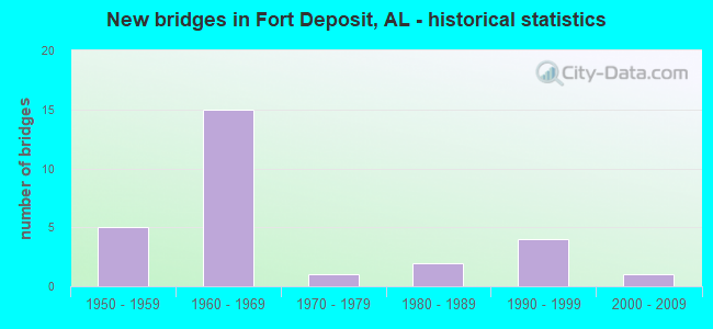
- New bridges - historical statistics
- 51950-1959
- 151960-1969
- 11970-1979
- 21980-1989
- 41990-1999
- 12000-2009


- Bridge Condition - Deck
- 10.0%Good
- 30.0%Satisfactory
- 60.0%Fair

- Bridge Condition - Superstructure
- 10.0%Good
- 80.0%Satisfactory
- 10.0%Fair

- Bridge Condition - Substructure
- 30.0%Good
- 50.0%Satisfactory
- 20.0%Fair

- Bridge Condition - Channel
- 9.5%Very good
- 38.1%Good
- 42.9%Satisfactory
- 4.8%Fair
- 4.8%Poor

- Bridge Condition - Culverts
- 33.3%Very good
- 13.3%Good
- 33.3%Satisfactory
- 13.3%Fair
- 6.7%Poor
Find on map >> Show street view
Structure Number: 3631, Location: 1.0MI N OF C.R.77 (Lat: 31.931667, Lng: -86.536667), Route carried "on" structure: US 31, Year Built: 1950, Status: Open, Structure Length: 0.67m (2.20ft), Average Daily Traffic: 1,930 (year 2013), Truck Traffic: 16%, Average Future Daily Traffic: 2,479 (year 2033), Design Load: H 15, Features Intersected: STREAM
Minimum Vertical Clearance: 30+ m (98+ ft), Kilometerpoint: 235.350, Lanes on structure: 2, Owner: State Highway Agency, Approaching Roadway Width: 15.2m (49.9ft), Material/Design: Concrete continuous, Design/Construction: Culvert, Number Of Spans In Main Unit: 2, Length of Maximum Span: 3.0m (9.8ft)
Condition: Channel: Satisfactory, Culverts: Satisfactory, Operating Rating: 88.9 metric tons, Method Used To Determine Operating Rating: Load Factor (LF), Inventory Rating: 70.9 metric tons, Method Used To Determine Inventory Rating: Load Factor (LF), Structural Evaluation: Equal to present minimum criteria, Waterway Adequacy: Better than present minimum criteria, Approach Roadway Alignment: Equal to present minimum criteria, Length Of Structure Improvement: 1.30m (4.27ft), Designated Inspection Frequency: Every 24 months, Inspection Date: July 2021, Bridge Improvement Cost: $495,000, Roadway Improvement Cost: $50,000, Total Project Cost: $545,000 ( Estimate for 2022)
Find on map >> Show street view
Structure Number: 3632, Location: 08.2 MI N JCT AL 10 (Lat: 31.937767, Lng: -86.529353), Route carried "on" structure: US 31, Year Built: 1950, Status: Open, Structure Length: 5.18m (16.99ft), Average Daily Traffic: 1,930 (year 2013), Truck Traffic: 16%, Average Future Daily Traffic: 2,479 (year 2033), Design Load: HS 20, Features Intersected: PIGEON CREEK
Minimum Vertical Clearance: 30+ m (98+ ft), Kilometerpoint: 236.768, Lanes on structure: 2, Owner: State Highway Agency, Approaching Roadway Width: 15.2m (49.9ft), Material/Design: Steel, Design/Construction: Stringer/Multi-beam, Number Of Spans In Main Unit: 5, Length of Maximum Span: 10.4m (34.1ft), Curb-To-Curb Width: 8.5m (27.9ft), Out-to-Out Width: 9.4m (30.8ft)
Condition: Deck: Satisfactory, Superstructure: Satisfactory, Substructure: Satisfactory, Channel: Satisfactory, Operating Rating: 56.5 metric tons, Method Used To Determine Operating Rating: Load Factor (LF), Inventory Rating: 33.8 metric tons, Method Used To Determine Inventory Rating: Load Factor (LF), Structural Evaluation: Equal to present minimum criteria, Deck Geometry: Somewhat better than minimum adequacy, Waterway Adequacy: Better than present minimum criteria, Approach Roadway Alignment: Better than present minimum criteria, Length Of Structure Improvement: 6.20m (20.34ft), Designated Inspection Frequency: Every 24 months, Inspection Date: July 2021, Bridge Improvement Cost: $1,276,000, Roadway Improvement Cost: $128,000, Total Project Cost: $1,404,000 ( Estimate for 2022), Deck Structure Type: Concrete Cast-file-Place
Find on map >> Show street view
Structure Number: 3633, Location: 9.0 MI N OF JCT AL 10 (Lat: 31.946472, Lng: -86.520233), Route carried "on" structure: US 31, Year Built: 1950, Status: Open, Structure Length: 4.15m (13.62ft), Average Daily Traffic: 1,370 (year 2013), Truck Traffic: 22%, Average Future Daily Traffic: 1,760 (year 2033), Design Load: HS 20, Features Intersected: PINEYWOOD CREEK
Minimum Vertical Clearance: 30+ m (98+ ft), Kilometerpoint: 238.020, Lanes on structure: 2, Owner: State Highway Agency, Approaching Roadway Width: 15.2m (49.9ft), Material/Design: Steel, Design/Construction: Stringer/Multi-beam, Number Of Spans In Main Unit: 4, Length of Maximum Span: 10.4m (34.1ft), Curb-To-Curb Width: 8.5m (27.9ft), Out-to-Out Width: 9.4m (30.8ft)
Condition: Deck: Fair, Superstructure: Satisfactory, Substructure: Good, Channel: Fair, Operating Rating: 56.5 metric tons, Method Used To Determine Operating Rating: Load Factor (LF), Inventory Rating: 33.8 metric tons, Method Used To Determine Inventory Rating: Load Factor (LF), Structural Evaluation: Equal to present minimum criteria, Deck Geometry: Somewhat better than minimum adequacy, Waterway Adequacy: Better than present minimum criteria, Approach Roadway Alignment: Better than present minimum criteria, Length Of Structure Improvement: 5.12m (16.80ft), Designated Inspection Frequency: Every 24 months, Inspection Date: July 2021, Bridge Improvement Cost: $1,053,000, Roadway Improvement Cost: $105,000, Total Project Cost: $1,158,000 ( Estimate for 2022), Deck Structure Type: Concrete Cast-file-Place
Find on map >> Show street view
Structure Number: 3635, Location: 0.6MI N BUTLER CO LINE (Lat: 31.970836, Lng: -86.498769), Route carried "on" structure: US 31, Year Built: 1950, Status: Open, Structure Length: 1.01m (3.31ft), Average Daily Traffic: 1,230 (year 2013), Truck Traffic: 23%, Average Future Daily Traffic: 1,580 (year 2033), Design Load: H 15, Features Intersected: STREAM
Minimum Vertical Clearance: 30+ m (98+ ft), Kilometerpoint: 241.435, Lanes on structure: 2, Owner: State Highway Agency, Approaching Roadway Width: 11.6m (38.1ft), Material/Design: Concrete continuous, Design/Construction: Culvert, Number Of Spans In Main Unit: 3, Length of Maximum Span: 3.0m (9.8ft)
Condition: Channel: Good, Culverts: Satisfactory, Operating Rating: 86.9 metric tons, Method Used To Determine Operating Rating: Load Factor (LF), Inventory Rating: 52.2 metric tons, Method Used To Determine Inventory Rating: Load Factor (LF), Structural Evaluation: Equal to present minimum criteria, Waterway Adequacy: Superior to present desirable criteria, Approach Roadway Alignment: Better than present minimum criteria, Length Of Structure Improvement: 1.68m (5.51ft), Designated Inspection Frequency: Every 24 months, Inspection Date: July 2021, Bridge Improvement Cost: $650,000, Roadway Improvement Cost: $65,000, Total Project Cost: $715,000 ( Estimate for 2022)
Find on map >> Show street view
Structure Number: 4871, Location: 2MI N. OF SR185 (Lat: 32.019806, Lng: -86.555472), Route carried "on" structure: County highway 37, Year Built: 1954, Status: Posted for load, Structure Length: 4.01m (13.16ft), Average Daily Traffic: 660 (year 2015), Truck Traffic: 5%, Average Future Daily Traffic: 720 (year 2035), Design Load: H 15, Features Intersected: CS XRR
Minimum Vertical Clearance: 30+ m (98+ ft), Kilometerpoint: 0.010, Lanes on structure: 2, Owner: County Highway Agency, Approaching Roadway Width: 7.0m (23.0ft), Material/Design: Concrete, Design/Construction: Tee Beam, Number Of Spans In Main Unit: 3, Length of Maximum Span: 13.4m (44.0ft), Curb-To-Curb Width: 6.6m (21.7ft), Out-to-Out Width: 7.1m (23.3ft)
Condition: Deck: Fair, Superstructure: Fair, Substructure: Fair, Operating Rating: 36.7 metric tons, Method Used To Determine Operating Rating: Load Factor (LF), Inventory Rating: 22.0 metric tons, Method Used To Determine Inventory Rating: Load Factor (LF), Structural Evaluation: Somewhat better than minimum adequacy, Deck Geometry: High priority of corrective action, Approach Roadway Alignment: Somewhat better than minimum adequacy, Bridge Posting: Required (Relationship of Operating Rating to Maximum Legal Load: 0.1 - 9.9% below), Length Of Structure Improvement: 4.97m (16.31ft), Designated Inspection Frequency: Every 24 months, Other Special Inspection Frequency: Every 12 months, Inspection Date: April 2021, Other Special Inspection Date: April 2021, Bridge Improvement Cost: $784,000, Roadway Improvement Cost: $78,000, Total Project Cost: $862,000 ( Estimate for 2022), Deck Structure Type: Concrete Cast-file-Place
Find on map >> Show street view
Structure Number: 7435, Location: 1.2 MI.W.BETHEL CHURCH (Lat: 31.952900, Lng: -86.482250), Route carried "on" structure: County highway 60, Year Built: 1961, Status: Open, Structure Length: 0.78m (2.56ft), Average Daily Traffic: 145 (year 2018), Truck Traffic: 28%, Average Future Daily Traffic: 220 (year 2040), Design Load: HS 20, Features Intersected: BRANCH OF THREE RUNCREEK
Minimum Vertical Clearance: 30+ m (98+ ft), Kilometerpoint: 0.010, Lanes on structure: 2, Owner: County Highway Agency, Approaching Roadway Width: 6.1m (20.0ft), Material/Design: Concrete, Design/Construction: Culvert, Number Of Spans In Main Unit: 2, Length of Maximum Span: 3.7m (12.1ft)
Condition: Channel: Good, Culverts: Satisfactory, Operating Rating: 49.1 metric tons, Method Used To Determine Operating Rating: Load Factor (LF), Inventory Rating: 29.5 metric tons, Method Used To Determine Inventory Rating: Load Factor (LF), Structural Evaluation: Equal to present minimum criteria, Waterway Adequacy: Equal to present desirable criteria, Approach Roadway Alignment: Equal to present minimum criteria, Length Of Structure Improvement: 1.44m (4.72ft), Designated Inspection Frequency: Every 24 months, Inspection Date: October 2020, Bridge Improvement Cost: $332,000, Roadway Improvement Cost: $33,000, Total Project Cost: $365,000 ( Estimate for 2022)
Find on map >> Show street view
Structure Number: 8982, Location: CO RD 75 OVER I65 (Lat: 31.960283, Lng: -86.542667), Route carried "on" structure: County highway 75, Year Built: 1966, Status: Open, Structure Length: 9.66m (31.69ft), Average Daily Traffic: 610 (year 2009), Truck Traffic: 1%, Average Future Daily Traffic: 635 (year 2029), Design Load: H 20, Features Intersected: I65
Minimum Vertical Clearance: 30+ m (98+ ft), Kilometerpoint: 10.239, Lanes on structure: 2, Lanes under structure: 4, Owner: State Highway Agency, Approaching Roadway Width: 11.0m (36.1ft), Skew: 2 degrees, Material/Design: Steel, Design/Construction: Stringer/Multi-beam, Number Of Spans In Main Unit: 4, Length of Maximum Span: 25.0m (82.0ft), Curb-To-Curb Width: 7.3m (24.0ft), Out-to-Out Width: 8.8m (28.9ft)
Condition: Deck: Satisfactory, Superstructure: Satisfactory, Substructure: Good, Operating Rating: 66.1 metric tons, Method Used To Determine Operating Rating: Load Factor (LF), Inventory Rating: 39.6 metric tons, Method Used To Determine Inventory Rating: Load Factor (LF), Structural Evaluation: Equal to present minimum criteria, Deck Geometry: Meets minimum limits, Underclear: Equal to present minimum criteria, Approach Roadway Alignment: Better than present minimum criteria, Length Of Structure Improvement: 10.60m (34.78ft), Designated Inspection Frequency: Every 24 months, Inspection Date: Febuary 2021, Bridge Improvement Cost: $2,036,000, Roadway Improvement Cost: $204,000, Total Project Cost: $2,240,000 ( Estimate for 2022), Deck Structure Type: Concrete Cast-file-Place
Find on map >> Show street view
Structure Number: 8983, Location: 0.2 MI N OF CO RD 75 (Lat: 31.962517, Lng: -86.540400), Route carried "on" structure: Interstate 65, Year Built: 1966, Status: Open, Structure Length: 1.31m (4.30ft), Average Daily Traffic: 29,840 (year 2013), Truck Traffic: 24%, Average Future Daily Traffic: 37,805 (year 2033), Design Load: H 20, Features Intersected: PINEY WOODS CREEK
Minimum Vertical Clearance: 30+ m (98+ ft), Kilometerpoint: 224.990, Lanes on structure: 4, Base Highway Network: Yes, Owner: State Highway Agency, Approaching Roadway Width: 24.4m (80.1ft), Skew: 10 degrees, Material/Design: Concrete continuous, Design/Construction: Culvert, Number Of Spans In Main Unit: 4, Length of Maximum Span: 3.0m (9.8ft)
Condition: Channel: Satisfactory, Culverts: Fair, Operating Rating: 88.9 metric tons, Method Used To Determine Operating Rating: Load Factor (LF), Inventory Rating: 88.9 metric tons, Method Used To Determine Inventory Rating: Load Factor (LF), Structural Evaluation: Somewhat better than minimum adequacy, Waterway Adequacy: Better than present minimum criteria, Approach Roadway Alignment: Better than present minimum criteria, Length Of Structure Improvement: 1.98m (6.50ft), Designated Inspection Frequency: Every 24 months, Inspection Date: Febuary 2021, Bridge Improvement Cost: $3,174,000, Roadway Improvement Cost: $317,000, Total Project Cost: $3,491,000 ( Estimate for 2022)
Find on map >> Show street view
Structure Number: 8984, Location: 0.5 MI.N.OF BUTLER CO. (Lat: 31.971139, Lng: -86.534572), Route carried "on" structure: Interstate 65, Year Built: 1966, Status: Open, Structure Length: 1.65m (5.41ft), Average Daily Traffic: 14,920 (year 2013), Truck Traffic: 24%, Average Future Daily Traffic: 18,902 (year 2033), Design Load: H 20, Features Intersected: BRANCH
Minimum Vertical Clearance: 30+ m (98+ ft), Kilometerpoint: 226.122, Lanes on structure: 2, Base Highway Network: Yes, Owner: State Highway Agency, Approaching Roadway Width: 12.2m (40.0ft), Skew: 14 degrees, Material/Design: Concrete continuous, Design/Construction: Culvert, Number Of Spans In Main Unit: 3, Length of Maximum Span: 3.7m (12.1ft)
Condition: Channel: Good, Culverts: Satisfactory, Operating Rating: 88.9 metric tons, Method Used To Determine Operating Rating: Load Factor (LF), Inventory Rating: 88.9 metric tons, Method Used To Determine Inventory Rating: Load Factor (LF), Structural Evaluation: Equal to present minimum criteria, Waterway Adequacy: Superior to present desirable criteria, Approach Roadway Alignment: Better than present minimum criteria, Length Of Structure Improvement: 2.34m (7.68ft), Designated Inspection Frequency: Every 24 months, Inspection Date: January 2021, Bridge Improvement Cost: $1,891,000, Roadway Improvement Cost: $189,000, Total Project Cost: $2,080,000 ( Estimate for 2022)
Find on map >> Show street view
Structure Number: 8985, Location: 0.8 MI.N.OF BUTLER CO. (Lat: 31.974731, Lng: -86.534489), Route carried "on" structure: Interstate 65, Year Built: 1966, Status: Open, Structure Length: 1.40m (4.59ft), Average Daily Traffic: 14,920 (year 2013), Truck Traffic: 24%, Average Future Daily Traffic: 18,902 (year 2033), Design Load: H 20, Features Intersected: BRANCH
Minimum Vertical Clearance: 30+ m (98+ ft), Kilometerpoint: 226.510, Lanes on structure: 2, Base Highway Network: Yes, Owner: State Highway Agency, Approaching Roadway Width: 12.2m (40.0ft), Skew: 14 degrees, Material/Design: Concrete continuous, Design/Construction: Culvert, Number Of Spans In Main Unit: 3, Length of Maximum Span: 3.0m (9.8ft)
Condition: Channel: Poor, Culverts: Poor, Operating Rating: 88.9 metric tons, Method Used To Determine Operating Rating: Load Factor (LF), Inventory Rating: 88.9 metric tons, Method Used To Determine Inventory Rating: Load Factor (LF), Structural Evaluation: Meets minimum limits, Waterway Adequacy: Better than present minimum criteria, Approach Roadway Alignment: Better than present minimum criteria, Length Of Structure Improvement: 2.07m (6.79ft), Designated Inspection Frequency: Every 24 months, Other Special Inspection Frequency: Every 12 months, Inspection Date: Febuary 2022, Other Special Inspection Date: Febuary 2022, Bridge Improvement Cost: $1,521,000, Roadway Improvement Cost: $152,000, Total Project Cost: $1,673,000 ( Estimate for 2022)
Find on map >> Show street view
Structure Number: 8986, Location: I65 * AL.185 INTERCHANGE (Lat: 31.983686, Lng: -86.531033), Route carried "on" structure: Ramp Interstate 65, Year Built: 1966, Status: Open, Structure Length: 0.76m (2.49ft), Average Daily Traffic: 2,984 (year 2013), Truck Traffic: 24%, Average Future Daily Traffic: 3,780 (year 2033), Design Load: H 20, Features Intersected: BRANCH, Facility Carried by Structure: S.W.RAMP A
Minimum Vertical Clearance: 30+ m (98+ ft), Kilometerpoint: 227.598, Lanes on structure: 1, Base Highway Network: Yes, Owner: State Highway Agency, Approaching Roadway Width: 7.3m (24.0ft), Skew: 4 degrees, Material/Design: Concrete continuous, Design/Construction: Culvert, Number Of Spans In Main Unit: 3, Length of Maximum Span: 2.1m (6.9ft)
Condition: Channel: Satisfactory, Culverts: Satisfactory, Operating Rating: 88.9 metric tons, Method Used To Determine Operating Rating: Load Factor (LF), Inventory Rating: 88.9 metric tons, Method Used To Determine Inventory Rating: Load Factor (LF), Structural Evaluation: Equal to present minimum criteria, Waterway Adequacy: Superior to present desirable criteria, Approach Roadway Alignment: Better than present minimum criteria, Length Of Structure Improvement: 1.41m (4.63ft), Designated Inspection Frequency: Every 24 months, Inspection Date: Febuary 2021, Bridge Improvement Cost: $260,000, Roadway Improvement Cost: $26,000, Total Project Cost: $286,000 ( Estimate for 2022)
Find on map >> Show street view
Structure Number: 8988, Location: I65 * AL.185 INTERCHANGE (Lat: 31.986667, Lng: -86.528333), Route carried "on" structure: Ramp Interstate 65, Year Built: 1966, Status: Open, Structure Length: 0.76m (2.49ft), Average Daily Traffic: 2,785 (year 2013), Truck Traffic: 24%, Average Future Daily Traffic: 3,528 (year 2033), Design Load: H 20, Features Intersected: BRANCH
Minimum Vertical Clearance: 30+ m (98+ ft), Kilometerpoint: 227.954, Lanes on structure: 1, Base Highway Network: Yes, Owner: State Highway Agency, Approaching Roadway Width: 7.3m (24.0ft), Material/Design: Concrete continuous, Design/Construction: Culvert, Number Of Spans In Main Unit: 3, Length of Maximum Span: 2.1m (6.9ft)
Condition: Channel: Satisfactory, Culverts: Fair, Operating Rating: 88.9 metric tons, Method Used To Determine Operating Rating: Load Factor (LF), Inventory Rating: 88.9 metric tons, Method Used To Determine Inventory Rating: Load Factor (LF), Structural Evaluation: Somewhat better than minimum adequacy, Waterway Adequacy: Superior to present desirable criteria, Approach Roadway Alignment: Better than present minimum criteria, Length Of Structure Improvement: 1.41m (4.63ft), Designated Inspection Frequency: Every 24 months, Inspection Date: Febuary 2021, Bridge Improvement Cost: $537,000, Roadway Improvement Cost: $54,000, Total Project Cost: $591,000 ( Estimate for 2022)
Find on map >> Show street view
Structure Number: 8989, Location: 4.5 MI.N.OF BUTLER CO. (Lat: 32.025636, Lng: -86.512414), Route carried "on" structure: County highway 33, Year Built: 1966, Status: Open, Structure Length: 8.08m (26.51ft), Average Daily Traffic: 628 (year 2009), Truck Traffic: 1%, Average Future Daily Traffic: 654 (year 2029), Design Load: H 20, Features Intersected: I65, Facility Carried by Structure: CO RD.
Minimum Vertical Clearance: 30+ m (98+ ft), Kilometerpoint: 6.029, Lanes on structure: 2, Lanes under structure: 4, Owner: State Highway Agency, Approaching Roadway Width: 7.3m (24.0ft), Skew: 1 degrees, Material/Design: Concrete continuous, Design/Construction: Tee Beam, Number Of Spans In Main Unit: 4, Length of Maximum Span: 22.3m (73.2ft), Curb-To-Curb Width: 7.3m (24.0ft), Out-to-Out Width: 8.8m (28.9ft)
Condition: Deck: Good, Superstructure: Good, Substructure: Satisfactory, Operating Rating: 50.7 metric tons, Method Used To Determine Operating Rating: Allowable Stress (AS), Inventory Rating: 21.8 metric tons, Method Used To Determine Inventory Rating: Allowable Stress (AS), Structural Evaluation: Somewhat better than minimum adequacy, Deck Geometry: Meets minimum limits, Underclear: Equal to present minimum criteria, Approach Roadway Alignment: Better than present minimum criteria, Length Of Structure Improvement: 9.08m (29.79ft), Designated Inspection Frequency: Every 24 months, Inspection Date: January 2021, Bridge Improvement Cost: $1,744,000, Roadway Improvement Cost: $174,000, Total Project Cost: $1,918,000 ( Estimate for 2022), Deck Structure Type: Concrete Cast-file-Place
Find on map >> Show street view
Structure Number: 899, Location: 4.7 MI.N.OF BUTLER CO. (Lat: 32.028122, Lng: -86.511281), Route carried "on" structure: Interstate 65, Year Built: 1966, Status: Open, Structure Length: 8.29m (27.20ft), Average Daily Traffic: 13,925 (year 2013), Truck Traffic: 24%, Average Future Daily Traffic: 17,642 (year 2033), Design Load: HS 20, Features Intersected: BIG SWAMP CREEK
Minimum Vertical Clearance: 30+ m (98+ ft), Kilometerpoint: 232.872, Lanes on structure: 2, Base Highway Network: Yes, Owner: State Highway Agency, Approaching Roadway Width: 12.2m (40.0ft), Skew: 13 degrees, Material/Design: Concrete, Design/Construction: Tee Beam, Number Of Spans In Main Unit: 8, Length of Maximum Span: 10.4m (34.1ft), Curb-To-Curb Width: 8.5m (27.9ft), Out-to-Out Width: 10.1m (33.1ft)
Condition: Deck: Fair, Superstructure: Satisfactory, Substructure: Satisfactory, Channel: Satisfactory, Operating Rating: 43.5 metric tons, Method Used To Determine Operating Rating: Load Factor (LF), Inventory Rating: 26.1 metric tons, Method Used To Determine Inventory Rating: Load Factor (LF), Structural Evaluation: Equal to present minimum criteria, Deck Geometry: High priority of corrective action, Waterway Adequacy: Superior to present desirable criteria, Approach Roadway Alignment: Better than present minimum criteria, Length Of Structure Improvement: 9.29m (30.48ft), Designated Inspection Frequency: Every 24 months, Inspection Date: Febuary 2021, Bridge Improvement Cost: $2,102,000, Roadway Improvement Cost: $210,000, Total Project Cost: $2,312,000 ( Estimate for 2022), Deck Structure Type: Concrete Cast-file-Place
Find on map >> Show street view
Structure Number: 8991, Location: 4.7 MI.N.OF BUTLER CO. (Lat: 32.027958, Lng: -86.511089), Route carried "on" structure: Interstate 65, Year Built: 1966, Status: Open, Structure Length: 8.29m (27.20ft), Average Daily Traffic: 13,925 (year 2013), Truck Traffic: 24%, Average Future Daily Traffic: 17,642 (year 2033), Design Load: HS 20, Features Intersected: BIG SWAMP CREEK
Minimum Vertical Clearance: 30+ m (98+ ft), Kilometerpoint: 232.872, Lanes on structure: 2, Base Highway Network: Yes, Owner: State Highway Agency, Approaching Roadway Width: 12.2m (40.0ft), Skew: 13 degrees, Material/Design: Concrete, Design/Construction: Tee Beam, Number Of Spans In Main Unit: 8, Length of Maximum Span: 10.4m (34.1ft), Curb-To-Curb Width: 8.5m (27.9ft), Out-to-Out Width: 10.1m (33.1ft)
Condition: Deck: Fair, Superstructure: Satisfactory, Substructure: Satisfactory, Channel: Satisfactory, Operating Rating: 43.5 metric tons, Method Used To Determine Operating Rating: Load Factor (LF), Inventory Rating: 26.1 metric tons, Method Used To Determine Inventory Rating: Load Factor (LF), Structural Evaluation: Equal to present minimum criteria, Deck Geometry: High priority of corrective action, Waterway Adequacy: Superior to present desirable criteria, Approach Roadway Alignment: Better than present minimum criteria, Length Of Structure Improvement: 9.29m (30.48ft), Designated Inspection Frequency: Every 24 months, Inspection Date: Febuary 2021, Bridge Improvement Cost: $2,102,000, Roadway Improvement Cost: $210,000, Total Project Cost: $2,312,000 ( Estimate for 2022), Deck Structure Type: Concrete Cast-file-Place
Find on map >> Show street view
Structure Number: 9028, Location: 2 MI NORTH OF AL 185 (Lat: 32.011075, Lng: -86.511061), Route carried "on" structure: County highway , Year Built: 1993, Status: Open, Structure Length: 1.13m (3.71ft), Average Daily Traffic: 110 (year 2003), Truck Traffic: 5%, Average Future Daily Traffic: 140 (year 2028), Design Load: HS 20, Features Intersected: CREEK, Facility Carried by Structure: GOLSON RD 185-37
Minimum Vertical Clearance: 30+ m (98+ ft), Kilometerpoint: 0.010, Lanes on structure: 2, Owner: County Highway Agency, Approaching Roadway Width: 8.5m (27.9ft), Skew: 3 degrees, Material/Design: Concrete, Design/Construction: Culvert, Number Of Spans In Main Unit: 3, Length of Maximum Span: 3.0m (9.8ft)
Condition: Channel: Satisfactory, Culverts: Very good, Operating Rating: 88.9 metric tons, Method Used To Determine Operating Rating: Load Factor (LF), Inventory Rating: 80.2 metric tons, Method Used To Determine Inventory Rating: Load Factor (LF), Structural Evaluation: Equal to present desirable criteria, Waterway Adequacy: Somewhat better than minimum adequacy, Approach Roadway Alignment: Equal to present minimum criteria, Length Of Structure Improvement: 1.81m (5.94ft), Designated Inspection Frequency: Every 24 months, Inspection Date: January 2021, Bridge Improvement Cost: $500,000, Roadway Improvement Cost: $50,000, Total Project Cost: $550,000 ( Estimate for 2022)
Find on map >> Show street view
Structure Number: 9263, Location: 5.4 MI N OF CO RD 45 (Lat: 31.945150, Lng: -86.559539), Route carried "on" structure: Interstate 65, Year Built: 1967, Status: Open, Structure Length: 8.23m (27.00ft), Average Daily Traffic: 14,920 (year 2013), Truck Traffic: 24%, Average Future Daily Traffic: 18,902 (year 2033), Design Load: HS 20, Features Intersected: PIGEON CREEK
Minimum Vertical Clearance: 30+ m (98+ ft), Kilometerpoint: 222.386, Lanes on structure: 2, Base Highway Network: Yes, Owner: State Highway Agency, Approaching Roadway Width: 12.2m (40.0ft), Skew: 14 degrees, Material/Design: Concrete, Design/Construction: Tee Beam, Number Of Spans In Main Unit: 8, Length of Maximum Span: 10.4m (34.1ft), Curb-To-Curb Width: 8.5m (27.9ft), Out-to-Out Width: 10.1m (33.1ft)
Condition: Deck: Fair, Superstructure: Satisfactory, Substructure: Fair, Channel: Satisfactory, Operating Rating: 43.5 metric tons, Method Used To Determine Operating Rating: Load Factor (LF), Inventory Rating: 26.1 metric tons, Method Used To Determine Inventory Rating: Load Factor (LF), Structural Evaluation: Somewhat better than minimum adequacy, Deck Geometry: High priority of corrective action, Waterway Adequacy: Superior to present desirable criteria, Approach Roadway Alignment: Better than present minimum criteria, Length Of Structure Improvement: 9.23m (30.28ft), Designated Inspection Frequency: Every 24 months, Inspection Date: Febuary 2021, Bridge Improvement Cost: $2,088,000, Roadway Improvement Cost: $209,000, Total Project Cost: $2,297,000 ( Estimate for 2022), Deck Structure Type: Concrete Cast-file-Place
Find on map >> Show street view
Structure Number: 9264, Location: 5.4 MI N OF CO 45 (Lat: 31.945161, Lng: -86.559172), Route carried "on" structure: Interstate 65, Year Built: 1967, Status: Open, Structure Length: 8.23m (27.00ft), Average Daily Traffic: 14,920 (year 2013), Truck Traffic: 24%, Average Future Daily Traffic: 18,902 (year 2033), Design Load: HS 20, Features Intersected: PIGEON CREEK
Minimum Vertical Clearance: 30+ m (98+ ft), Kilometerpoint: 222.386, Lanes on structure: 2, Base Highway Network: Yes, Owner: State Highway Agency, Approaching Roadway Width: 12.2m (40.0ft), Skew: 14 degrees, Material/Design: Concrete, Design/Construction: Tee Beam, Number Of Spans In Main Unit: 8, Length of Maximum Span: 10.4m (34.1ft), Curb-To-Curb Width: 8.5m (27.9ft), Out-to-Out Width: 10.1m (33.1ft)
Condition: Deck: Fair, Superstructure: Satisfactory, Substructure: Satisfactory, Channel: Good, Operating Rating: 43.5 metric tons, Method Used To Determine Operating Rating: Load Factor (LF), Inventory Rating: 26.1 metric tons, Method Used To Determine Inventory Rating: Load Factor (LF), Structural Evaluation: Equal to present minimum criteria, Deck Geometry: High priority of corrective action, Waterway Adequacy: Superior to present desirable criteria, Approach Roadway Alignment: Better than present minimum criteria, Length Of Structure Improvement: 9.23m (30.28ft), Designated Inspection Frequency: Every 24 months, Inspection Date: Febuary 2021, Bridge Improvement Cost: $2,088,000, Roadway Improvement Cost: $209,000, Total Project Cost: $2,297,000 ( Estimate for 2022), Deck Structure Type: Concrete Cast-file-Place
Find on map >> Show street view
Structure Number: 12796, Location: 2.5 MI NW OF FT DEPOSIT (Lat: 32.013203, Lng: -86.618922), Route carried "on" structure: County highway 45, Year Built: 1982, Status: Open, Structure Length: 0.67m (2.20ft), Average Daily Traffic: 710 (year 2003), Truck Traffic: 5%, Average Future Daily Traffic: 730 (year 2030), Design Load: H 15, Features Intersected: BEAVER CREEK
Minimum Vertical Clearance: 30+ m (98+ ft), Kilometerpoint: 0.010, Lanes on structure: 2, Base Highway Network: Yes, Owner: County Highway Agency, Approaching Roadway Width: 9.1m (29.9ft), Material/Design: Concrete, Design/Construction: Culvert, Number Of Spans In Main Unit: 2, Length of Maximum Span: 3.0m (9.8ft)
Condition: Channel: Very good, Culverts: Good, Operating Rating: 58.6 metric tons, Method Used To Determine Operating Rating: Load Factor (LF), Inventory Rating: 35.2 metric tons, Method Used To Determine Inventory Rating: Load Factor (LF), Structural Evaluation: Better than present minimum criteria, Waterway Adequacy: Equal to present minimum criteria, Approach Roadway Alignment: Equal to present minimum criteria, Length Of Structure Improvement: 1.30m (4.27ft), Designated Inspection Frequency: Every 24 months, Inspection Date: January 2021, Bridge Improvement Cost: $330,000, Roadway Improvement Cost: $33,000, Total Project Cost: $363,000 ( Estimate for 2022)
Find on map >> Show street view
Structure Number: 12834, Location: 3.0 MI.S.OF I65 (Lat: 31.985000, Lng: -86.576667), Route carried "on" structure: State highway 185, Year Built: 1982, Status: Open, Structure Length: 3.84m (12.60ft), Average Daily Traffic: 3,570 (year 2013), Truck Traffic: 2%, Average Future Daily Traffic: 4,399 (year 2033), Design Load: HS 20, Features Intersected: L*N RR
Minimum Vertical Clearance: 30+ m (98+ ft), Kilometerpoint: 28.799, Lanes on structure: 2, Owner: State Highway Agency, Approaching Roadway Width: 8.5m (27.9ft), Skew: 1 degrees, Material/Design: Steel continuous, Design/Construction: Stringer/Multi-beam, Number Of Spans In Main Unit: 3, Length of Maximum Span: 14.0m (45.9ft), Curb or Sidewalk Widths: Left: 0.0m, Right: 1.5m (4.9ft), Curb-To-Curb Width: 8.5m (27.9ft), Out-to-Out Width: 10.5m (34.4ft)
Condition: Deck: Satisfactory, Superstructure: Satisfactory, Substructure: Good, Operating Rating: 66.1 metric tons, Method Used To Determine Operating Rating: Load Factor (LF), Inventory Rating: 37.0 metric tons, Method Used To Determine Inventory Rating: Load Factor (LF), Structural Evaluation: Equal to present minimum criteria, Deck Geometry: Meets minimum limits, Underclear: Better than present minimum criteria, Approach Roadway Alignment: Somewhat better than minimum adequacy, Length Of Structure Improvement: 4.78m (15.68ft), Designated Inspection Frequency: Every 24 months, Inspection Date: October 2020, Bridge Improvement Cost: $1,114,000, Roadway Improvement Cost: $111,000, Total Project Cost: $1,225,000 ( Estimate for 2022), Deck Structure Type: Concrete Cast-file-Place
Find on map >> Show street view
Structure Number: 15085, Location: 3 MI NORTH OF AL 185 (Lat: 32.019711, Lng: -86.505206), Route carried "on" structure: County highway , Year Built: 1990, Status: Open, Structure Length: 0.67m (2.20ft), Average Daily Traffic: 100 (year 2003), Average Future Daily Traffic: 120 (year 2028), Design Load: HS 20, Features Intersected: CREEK, Facility Carried by Structure: GOLSON RD 185-37
Minimum Vertical Clearance: 30+ m (98+ ft), Kilometerpoint: 0.010, Lanes on structure: 2, Owner: County Highway Agency, Approaching Roadway Width: 8.5m (27.9ft), Material/Design: Concrete, Design/Construction: Culvert, Number Of Spans In Main Unit: 2, Length of Maximum Span: 3.0m (9.8ft)
Condition: Channel: Good, Culverts: Very good, Operating Rating: 88.9 metric tons, Method Used To Determine Operating Rating: Load Factor (LF), Inventory Rating: 54.2 metric tons, Method Used To Determine Inventory Rating: Load Factor (LF), Structural Evaluation: Equal to present desirable criteria, Waterway Adequacy: Somewhat better than minimum adequacy, Approach Roadway Alignment: Equal to present minimum criteria, Length Of Structure Improvement: 1.30m (4.27ft), Designated Inspection Frequency: Every 24 months, Inspection Date: January 2021, Bridge Improvement Cost: $315,000, Roadway Improvement Cost: $32,000, Total Project Cost: $347,000 ( Estimate for 2022)
Find on map >> Show street view
Structure Number: 15907, Location: 2.0 MI. NE SEARCY (Lat: 31.919300, Lng: -86.580500), Route carried "on" structure: County highway 45, Year Built: 1993, Status: Open, Structure Length: 1.31m (4.30ft), Average Daily Traffic: 383 (year 2018), Truck Traffic: 16%, Average Future Daily Traffic: 475 (year 2040), Design Load: HS 20, Features Intersected: HALLS CREEK
Minimum Vertical Clearance: 30+ m (98+ ft), Kilometerpoint: 0.010, Lanes on structure: 2, Owner: County Highway Agency, Approaching Roadway Width: 9.1m (29.9ft), Skew: 3 degrees, Material/Design: Concrete, Design/Construction: Culvert, Number Of Spans In Main Unit: 3, Length of Maximum Span: 3.7m (12.1ft)
Condition: Channel: Good, Culverts: Good, Operating Rating: 67.9 metric tons, Method Used To Determine Operating Rating: Load Factor (LF), Inventory Rating: 40.7 metric tons, Method Used To Determine Inventory Rating: Load Factor (LF), Structural Evaluation: Better than present minimum criteria, Waterway Adequacy: Equal to present desirable criteria, Approach Roadway Alignment: Equal to present desirable criteria, Length Of Structure Improvement: 1.98m (6.50ft), Designated Inspection Frequency: Every 24 months, Inspection Date: December 2020, Bridge Improvement Cost: $562,000, Roadway Improvement Cost: $56,000, Total Project Cost: $618,000 ( Estimate for 2022)
Find on map >> Show street view
Structure Number: 16795, Location: 3MI S OF CO37 (Lat: 32.022089, Lng: -86.506825), Route carried "on" structure: County highway , Year Built: 1970, Year Reconstructed: 1996, Status: Open, Structure Length: 2.23m (7.32ft), Average Daily Traffic: 120 (year 2003), Truck Traffic: 5%, Average Future Daily Traffic: 120 (year 2028), Design Load: HS 20, Features Intersected: BIG SWAMP CREEK, Facility Carried by Structure: GOLSON RD
Minimum Vertical Clearance: 30+ m (98+ ft), Kilometerpoint: 0.010, Lanes on structure: 2, Owner: County Highway Agency, Approaching Roadway Width: 8.5m (27.9ft), Skew: 4 degrees, Material/Design: Concrete, Design/Construction: Culvert, Number Of Spans In Main Unit: 4, Length of Maximum Span: 3.7m (12.1ft), Curb-To-Curb Width: 12.2m (40.0ft), Out-to-Out Width: 12.8m (42.0ft)
Condition: Channel: Good, Culverts: Very good, Operating Rating: 68.4 metric tons, Method Used To Determine Operating Rating: Load Factor (LF), Inventory Rating: 41.0 metric tons, Method Used To Determine Inventory Rating: Load Factor (LF), Structural Evaluation: Equal to present desirable criteria, Deck Geometry: Superior to present desirable criteria, Waterway Adequacy: Equal to present minimum criteria, Approach Roadway Alignment: Equal to present desirable criteria, Length Of Structure Improvement: 3.04m (9.97ft), Designated Inspection Frequency: Every 24 months, Inspection Date: January 2021, Bridge Improvement Cost: $1,036,000, Roadway Improvement Cost: $104,000, Total Project Cost: $1,140,000 ( Estimate for 2022)
Find on map >> Show street view
Structure Number: 17149, Location: 1 MI S CO 37 (Lat: 32.046369, Lng: -86.542450), Route carried "on" structure: County highway , Year Built: 1998, Status: Open, Structure Length: 1.56m (5.12ft), Average Daily Traffic: 100 (year 2003), Average Future Daily Traffic: 150 (year 2035), Design Load: HS 20, Features Intersected: BALLARDS CRK., Facility Carried by Structure: GOLSON RD 185-37
Minimum Vertical Clearance: 30+ m (98+ ft), Kilometerpoint: 0.000, Lanes on structure: 2, Owner: County Highway Agency, Approaching Roadway Width: 7.0m (23.0ft), Material/Design: Concrete, Design/Construction: Culvert, Number Of Spans In Main Unit: 4, Length of Maximum Span: 3.7m (12.1ft)
Condition: Channel: Very good, Culverts: Very good, Operating Rating: 74.8 metric tons, Method Used To Determine Operating Rating: Load Factor (LF), Inventory Rating: 44.9 metric tons, Method Used To Determine Inventory Rating: Load Factor (LF), Structural Evaluation: Equal to present desirable criteria, Waterway Adequacy: Better than present minimum criteria, Approach Roadway Alignment: Equal to present desirable criteria, Length Of Structure Improvement: 2.24m (7.35ft), Designated Inspection Frequency: Every 24 months, Inspection Date: January 2021, Bridge Improvement Cost: $544,000, Roadway Improvement Cost: $54,000, Total Project Cost: $598,000 ( Estimate for 2022), Deck Structure Type: Concrete Cast-file-Place, Wearing Surface/Protective System: Wearing Surface: Gravel
Find on map >> Show street view
Structure Number: 18653, Location: 1 MI E OF CO 75 (Lat: 31.971314, Lng: -86.548864), Route carried "on" structure: County highway , Year Built: 2003, Status: Open, Structure Length: 0.94m (3.08ft), Average Daily Traffic: 20 (year 2003), Average Future Daily Traffic: 30 (year 2028), Design Load: HS 20, Features Intersected: AVINGER BRANCH, Facility Carried by Structure: REED RD. 185 TO 75
Minimum Vertical Clearance: 30+ m (98+ ft), Kilometerpoint: 0.000, Lanes on structure: 2, Owner: County Highway Agency, Approaching Roadway Width: 7.3m (24.0ft), Material/Design: Concrete, Design/Construction: Culvert, Number Of Spans In Main Unit: 3, Length of Maximum Span: 3.0m (9.8ft)
Condition: Channel: Good, Culverts: Very good, Operating Rating: 57.2 metric tons, Method Used To Determine Operating Rating: Load Factor (LF), Inventory Rating: 34.4 metric tons, Method Used To Determine Inventory Rating: Load Factor (LF), Structural Evaluation: Equal to present desirable criteria, Waterway Adequacy: Equal to present minimum criteria, Approach Roadway Alignment: Somewhat better than minimum adequacy, Length Of Structure Improvement: 1.62m (5.31ft), Designated Inspection Frequency: Every 24 months, Inspection Date: January 2021, Bridge Improvement Cost: $393,000, Roadway Improvement Cost: $39,000, Total Project Cost: $432,000 ( Estimate for 2022), Deck Structure Type: Concrete Cast-file-Place, Wearing Surface/Protective System: Wearing Surface: Gravel
Find on map >> Show street view
Structure Number: 8982, Location: CO RD 75 OVER I65 (Lat: 31.960283, Lng: -86.542667), Route carried "under" structure: Interstate 65, Year Built: 1966, Structure Length: 0. m, Average Daily Traffic: 29,840 (year 2013), Truck Traffic: 24%, Features Intersected: I65, Facility Carried by Structure: CO RD 75
Minimum Vertical Clearance: 6.48m (21.26ft), Kilometerpoint: 224.635, Lanes on structure: 2, Lanes under structure: 4, Material/Design: Steel, Design/Construction: Stringer/Multi-beam, Length of Maximum Span: 25.0m (82.0ft)
Find on map >> Show street view
Structure Number: 8989, Location: 4.5 MI.N.OF BUTLER CO. (Lat: 32.025636, Lng: -86.512414), Route carried "under" structure: Interstate 65, Year Built: 1966, Structure Length: 0. m, Average Daily Traffic: 27,850 (year 2013), Truck Traffic: 24%, Features Intersected: I65, Facility Carried by Structure: CO RD.
Minimum Vertical Clearance: 5.42m (17.78ft), Kilometerpoint: 232.592, Lanes on structure: 2, Lanes under structure: 4, Material/Design: Concrete continuous, Design/Construction: Tee Beam, Length of Maximum Span: 22.3m (73.2ft)
Find on map >> Show street view
Structure Number: 9178, Location: INT. I-65 * AL 185 (Lat: 31.985000, Lng: -86.528333), Route carried "under" structure: Interstate 65, Year Built: 1966, Structure Length: 0. m, Average Daily Traffic: 29,840 (year 2013), Truck Traffic: 24%, Features Intersected: I-65, Facility Carried by Structure: AL 185
Minimum Vertical Clearance: 5.21m (17.09ft), Kilometerpoint: 227.775, Lanes on structure: 2, Lanes under structure: 4, Material/Design: Concrete continuous, Design/Construction: Tee Beam, Length of Maximum Span: 20.7m (67.9ft)