Bridge Statistics for Fort Covington, New York (NY)
Condition, Traffic, Stress, Structural Evaluation, Project Costs
- National Bridge Inventory (NBI) Statistics
- 17Number of bridges
- 115ft / 34.9mTotal length
- $13,921,000Total costs
- 16,980Total average daily traffic
- 1,985Total average daily truck traffic
- 19,794Total future (year 2036) average daily traffic
- National Bridge Inventory (NBI) Registered Bridges for Fort Covington
- No street view available for this location
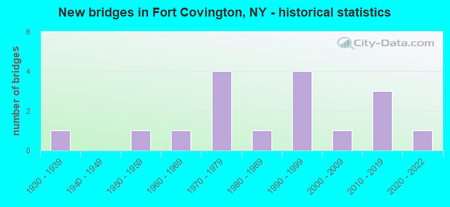
- New bridges - historical statistics
- 11930-1939
- 11950-1959
- 11960-1969
- 41970-1979
- 11980-1989
- 41990-1999
- 12000-2009
- 32010-2019
- 12020-2022

- Reconstructed bridges - Historical Statistics
- 11980-1989
- 11990-1999
- 02000-2009
- 12010-2019


- Bridge Condition - Deck
- 26.7%Excellent
- 6.7%Very good
- 40.0%Good
- 20.0%Satisfactory
- 6.7%Fair

- Bridge Condition - Superstructure
- 20.0%Excellent
- 33.3%Very good
- 33.3%Good
- 13.3%Satisfactory

- Bridge Condition - Substructure
- 13.3%Excellent
- 66.7%Very good
- 13.3%Good
- 6.7%Poor

- Bridge Condition - Channel
- 11.8%Excellent
- 23.5%Very good
- 41.2%Good
- 17.6%Satisfactory
- 5.9%Poor

- Bridge Condition - Culverts
- 50.0%Satisfactory
- 50.0%Poor
Find on map >> Show street view
Structure Number: 102395, Location: 5.3 MI E JCT RTS 37 + 95 (Lat: 44.975875, Lng: -74.543031), Route carried "on" structure: State highway 37, Year Built: 1955, Status: Open, Structure Length: 1.22m (4.00ft), Average Daily Traffic: 3,395 (year 2018), Truck Traffic: 13%, Average Future Daily Traffic: 3,427 (year 2040), Design Load: H 20, Features Intersected: PIKE CREEK
Minimum Vertical Clearance: 30+ m (98+ ft), Kilometerpoint: 14.803, Lanes on structure: 2, Base Highway Network: Yes, Owner: State Highway Agency, Approaching Roadway Width: 12.2m (40.0ft), Skew: 2 degrees, Material/Design: Concrete continuous, Design/Construction: Culvert, Number Of Spans In Main Unit: 2, Length of Maximum Span: 5.4m (17.7ft)
Condition: Channel: Good, Culverts: Satisfactory, Structural Evaluation: Equal to present minimum criteria, Waterway Adequacy: Somewhat better than minimum adequacy, Approach Roadway Alignment: Equal to present desirable criteria, Length Of Structure Improvement: 1.21m (3.97ft), Designated Inspection Frequency: Every 24 months, Inspection Date: October 2021, Bridge Improvement Cost: $582,000, Roadway Improvement Cost: $341,000, Total Project Cost: $923,000 ( Estimate for 2021)
Find on map >> Show street view
Structure Number: 102396, Location: IN FORT COVINGTON (Lat: 44.986394, Lng: -74.503147), Route carried "on" structure: State highway 37, Year Built: 1977, Status: Open, Structure Length: 3.02m (9.91ft), Average Daily Traffic: 3,395 (year 2018), Truck Traffic: 13%, Average Future Daily Traffic: 3,427 (year 2040), Design Load: HS 20, Features Intersected: W.BR.LIT.SALMON R
Minimum Vertical Clearance: 30+ m (98+ ft), Kilometerpoint: 18.198, Lanes on structure: 2, Base Highway Network: Yes, Owner: State Highway Agency, Approaching Roadway Width: 13.1m (43.0ft), Material/Design: Prestressed concrete, Design/Construction: Box Beam or Girders - Multiple, Number Of Spans In Main Unit: 1, Length of Maximum Span: 29.8m (97.8ft), Curb or Sidewalk Widths: Left: 1.5m (4.9ft), Right: 0.0m, Curb-To-Curb Width: 13.7m (44.9ft), Out-to-Out Width: 14.9m (48.9ft)
Condition: Deck: Satisfactory, Superstructure: Good, Substructure: Very good, Channel: Good, Operating Rating: 87.1 metric tons, Method Used To Determine Operating Rating: Load Factor (LF), Inventory Rating: 32.7 metric tons, Method Used To Determine Inventory Rating: Load Factor (LF), Structural Evaluation: Better than present minimum criteria, Deck Geometry: Superior to present desirable criteria, Waterway Adequacy: Equal to present minimum criteria, Approach Roadway Alignment: Equal to present desirable criteria, Length Of Structure Improvement: 3.01m (9.88ft), Designated Inspection Frequency: Every 24 months, Inspection Date: November 2020, Bridge Improvement Cost: $869,000, Roadway Improvement Cost: $509,000, Total Project Cost: $1,379,000 ( Estimate for 2021), Deck Structure Type: Concrete Cast-file-Place, Wearing Surface/Protective System: Wearing Surface: Bituminous, Membrane: Other
Find on map >> Show street view
Structure Number: 102397, Location: IN FORT COVINGTON (Lat: 44.988781, Lng: -74.495094), Route carried "on" structure: State highway 37, Year Built: 1998, Status: Open, Structure Length: 4.36m (14.30ft), Average Daily Traffic: 3,395 (year 2018), Truck Traffic: 13%, Average Future Daily Traffic: 3,427 (year 2040), Design Load: HS 25 or greater, Features Intersected: SALMON RIVER
Minimum Vertical Clearance: 30+ m (98+ ft), Kilometerpoint: 18.874, Lanes on structure: 2, Base Highway Network: Yes, Owner: State Highway Agency, Approaching Roadway Width: 12.2m (40.0ft), Material/Design: Steel, Design/Construction: Stringer/Multi-beam, Number Of Spans In Main Unit: 1, Length of Maximum Span: 42.0m (137.8ft), Curb or Sidewalk Widths: Left: 1.6m (5.2ft), Right: 1.6m (5.2ft), Curb-To-Curb Width: 12.0m (39.4ft), Out-to-Out Width: 15.7m (51.5ft)
Condition: Deck: Satisfactory, Superstructure: Very good, Substructure: Very good, Channel: Good, Operating Rating: 80.7 metric tons, Method Used To Determine Operating Rating: Load Factor (LF), Inventory Rating: 48.1 metric tons, Method Used To Determine Inventory Rating: Load Factor (LF), Structural Evaluation: Equal to present desirable criteria, Deck Geometry: Somewhat better than minimum adequacy, Waterway Adequacy: Somewhat better than minimum adequacy, Approach Roadway Alignment: Equal to present desirable criteria, Length Of Structure Improvement: 4.35m (14.27ft), Designated Inspection Frequency: Every 24 months, Inspection Date: September 2020, Bridge Improvement Cost: $1,947,000, Roadway Improvement Cost: $1,140,000, Total Project Cost: $3,087,000 ( Estimate for 2021), Deck Structure Type: Concrete Cast-file-Place, Wearing Surface/Protective System: Wearing Surface: Monolithic Concrete, Deck Protection: Epoxy Coated Reinforcing
Find on map >> Show street view
Structure Number: 221983, Location: 3 MI SW OF WESTVILLE CNTR (Lat: 44.914533, Lng: -74.445467), Route carried "on" structure: Other road , Year Built: 1999, Status: Open, Structure Length: 1.04m (3.41ft), Average Daily Traffic: 131 (year 2017), Truck Traffic: 7%, Average Future Daily Traffic: 183 (year 2037), Design Load: HS 25 or greater, Features Intersected: E BR DEER CREEK, Facility Carried by Structure: BUEL ROAD
Minimum Vertical Clearance: 30+ m (98+ ft), Kilometerpoint: 0.949, Lanes on structure: 1, Owner: Town or Township Highway Agency, Approaching Roadway Width: 4.6m (15.1ft), Material/Design: Prestressed concrete, Design/Construction: Box Beam or Girders - Multiple, Number Of Spans In Main Unit: 1, Length of Maximum Span: 10.0m (32.8ft), Curb-To-Curb Width: 4.6m (15.1ft), Out-to-Out Width: 5.4m (17.7ft)
Condition: Deck: Good, Superstructure: Very good, Substructure: Good, Channel: Satisfactory, Operating Rating: 78.0 metric tons, Method Used To Determine Operating Rating: Load Factor (LF), Inventory Rating: 46.3 metric tons, Method Used To Determine Inventory Rating: Load Factor (LF), Structural Evaluation: Better than present minimum criteria, Deck Geometry: High priority of replacement, Waterway Adequacy: Somewhat better than minimum adequacy, Approach Roadway Alignment: Equal to present minimum criteria, Length Of Structure Improvement: 1.03m (3.38ft), Designated Inspection Frequency: Every 24 months, Inspection Date: September 2021, Bridge Improvement Cost: $321,000, Roadway Improvement Cost: $188,000, Total Project Cost: $508,000 ( Estimate for 2021), Deck Structure Type: Concrete Cast-file-Place, Wearing Surface/Protective System: Wearing Surface: Integral Concrete, Deck Protection: Epoxy Coated Reinforcing
Find on map >> Show street view
Structure Number: 333736, Location: 1.9 MI SE OF FORT COVINGT (Lat: 44.965772, Lng: -74.467419), Route carried "on" structure: Other road , Year Built: 1976, Status: Open, Structure Length: 0.67m (2.20ft), Average Daily Traffic: 166 (year 2017), Truck Traffic: 7%, Average Future Daily Traffic: 232 (year 2037), Features Intersected: E BR DEER CREEK, Facility Carried by Structure: CUSHMAN ROAD
Minimum Vertical Clearance: 30+ m (98+ ft), Kilometerpoint: 0.290, Lanes on structure: 2, Owner: County Highway Agency, Approaching Roadway Width: 8.9m (29.2ft), Material/Design: Steel, Design/Construction: Culvert, Number Of Spans In Main Unit: 1, Length of Maximum Span: 6.4m (21.0ft)
Condition: Channel: Satisfactory, Culverts: Poor, Operating Rating: 76.7 metric tons, Method Used To Determine Operating Rating: Field evaluation and documented engineering judgment, Inventory Rating: 29.4 metric tons, Method Used To Determine Inventory Rating: Field evaluation and documented engineering judgment, Structural Evaluation: Meets minimum limits, Waterway Adequacy: Meets minimum limits, Approach Roadway Alignment: Meets minimum limits, Length Of Structure Improvement: 0.67m (2.20ft), Designated Inspection Frequency: Every 24 months, Inspection Date: May 2021, Bridge Improvement Cost: $74,000, Roadway Improvement Cost: $43,000, Total Project Cost: $117,000 ( Estimate for 2021)
Find on map >> Show street view
Structure Number: 333737, Location: IN FORT COVINGTON (Lat: 44.990947, Lng: -74.496383), Route carried "on" structure: Other road , Year Built: 1974, Year Reconstructed: 1997, Status: Open, Structure Length: 5.18m (16.99ft), Average Daily Traffic: 252 (year 2017), Truck Traffic: 7%, Average Future Daily Traffic: 353 (year 2037), Design Load: HS 25 or greater, Features Intersected: SALMON RIVER, Facility Carried by Structure: CENTER STREET
Minimum Vertical Clearance: 30+ m (98+ ft), Kilometerpoint: 0.338, Lanes on structure: 2, Owner: County Highway Agency, Approaching Roadway Width: 8.5m (27.9ft), Material/Design: Steel continuous, Design/Construction: Stringer/Multi-beam, Number Of Spans In Main Unit: 2, Length of Maximum Span: 25.2m (82.7ft), Curb-To-Curb Width: 7.8m (25.6ft), Out-to-Out Width: 8.4m (27.6ft)
Condition: Deck: Good, Superstructure: Very good, Substructure: Very good, Channel: Good, Operating Rating: 88.9 metric tons, Method Used To Determine Operating Rating: Load Factor (LF), Inventory Rating: 52.6 metric tons, Method Used To Determine Inventory Rating: Load Factor (LF), Structural Evaluation: Equal to present desirable criteria, Deck Geometry: Somewhat better than minimum adequacy, Waterway Adequacy: Somewhat better than minimum adequacy, Approach Roadway Alignment: Equal to present desirable criteria, Length Of Structure Improvement: 5.18m (16.99ft), Designated Inspection Frequency: Every 24 months, Inspection Date: June 2021, Bridge Improvement Cost: $1,093,000, Roadway Improvement Cost: $640,000, Total Project Cost: $1,732,000 ( Estimate for 2021), Deck Structure Type: Concrete Cast-file-Place, Wearing Surface/Protective System: Wearing Surface: Integral Concrete, Deck Protection: Epoxy Coated Reinforcing
Find on map >> Show street view
Structure Number: 333738, Location: 2 MI W OF FORT COVINGTON (Lat: 44.990722, Lng: -74.501564), Route carried "on" structure: County highway , Year Built: 1938, Year Reconstructed: 1992, Status: Open, Structure Length: 2.44m (8.01ft), Average Daily Traffic: 456 (year 2017), Truck Traffic: 7%, Average Future Daily Traffic: 638 (year 2037), Features Intersected: LITTLE SALMON RVR, Facility Carried by Structure: CR 43, PIKE STREE
Minimum Vertical Clearance: 30+ m (98+ ft), Kilometerpoint: 0.209, Lanes on structure: 2, Owner: County Highway Agency, Approaching Roadway Width: 6.1m (20.0ft), Material/Design: Steel, Design/Construction: Girder and Floorbeam System, Number Of Spans In Main Unit: 1, Length of Maximum Span: 24.0m (78.7ft), Curb-To-Curb Width: 5.9m (19.4ft), Out-to-Out Width: 6.7m (22.0ft)
Condition: Deck: Good, Superstructure: Satisfactory, Substructure: Good, Channel: Good, Operating Rating: 41.7 metric tons, Method Used To Determine Operating Rating: Load Factor (LF), Inventory Rating: 24.5 metric tons, Method Used To Determine Inventory Rating: Load Factor (LF), Structural Evaluation: Equal to present minimum criteria, Deck Geometry: High priority of replacement, Waterway Adequacy: Somewhat better than minimum adequacy, Approach Roadway Alignment: High priority of corrective action, Length Of Structure Improvement: 2.43m (7.97ft), Designated Inspection Frequency: Every 24 months, Critical Feature Inspection Frequency: Every 24 months, Inspection Date: June 2021, Critical Feature Inspection Date: June 2021, Bridge Improvement Cost: $405,000, Roadway Improvement Cost: $237,000, Total Project Cost: $641,000 ( Estimate for 2021), Deck Structure Type: Concrete Cast-file-Place, Wearing Surface/Protective System: Wearing Surface: Integral Concrete, Deck Protection: Epoxy Coated Reinforcing
Find on map >> Show street view
Structure Number: 333739, Location: 1.4 MI S OF FORT COVINGTN (Lat: 44.967033, Lng: -74.511575), Route carried "on" structure: Other road , Year Built: 1995, Status: Open, Structure Length: 2.23m (7.32ft), Average Daily Traffic: 287 (year 2020), Truck Traffic: 7%, Average Future Daily Traffic: 402 (year 2040), Design Load: HS 25 or greater, Features Intersected: LITT SALMON RIVER, Facility Carried by Structure: FOSTER ROAD
Minimum Vertical Clearance: 30+ m (98+ ft), Kilometerpoint: 3.154, Lanes on structure: 1, Owner: County Highway Agency, Approaching Roadway Width: 4.6m (15.1ft), Material/Design: Prestressed concrete, Design/Construction: Box Beam or Girders - Multiple, Number Of Spans In Main Unit: 1, Length of Maximum Span: 21.3m (69.9ft), Curb-To-Curb Width: 4.5m (14.8ft), Out-to-Out Width: 5.1m (16.7ft)
Condition: Deck: Satisfactory, Superstructure: Good, Substructure: Very good, Channel: Very good, Operating Rating: 74.4 metric tons, Method Used To Determine Operating Rating: Load Factor (LF), Inventory Rating: 44.5 metric tons, Method Used To Determine Inventory Rating: Load Factor (LF), Structural Evaluation: Better than present minimum criteria, Deck Geometry: High priority of replacement, Waterway Adequacy: Equal to present desirable criteria, Approach Roadway Alignment: Equal to present desirable criteria, Length Of Structure Improvement: 2.22m (7.28ft), Designated Inspection Frequency: Every 24 months, Inspection Date: June 2021, Bridge Improvement Cost: $268,000, Roadway Improvement Cost: $157,000, Total Project Cost: $426,000 ( Estimate for 2021), Deck Structure Type: Concrete Cast-file-Place, Wearing Surface/Protective System: Wearing Surface: Integral Concrete, Deck Protection: Epoxy Coated Reinforcing
Find on map >> Show street view
Structure Number: 33374, Location: 1.7MI NE BOMBAY (Lat: 44.958631, Lng: -74.558567), Route carried "on" structure: Other road , Year Built: 2012, Status: Open, Structure Length: 1.92m (6.30ft), Average Daily Traffic: 129 (year 2017), Truck Traffic: 7%, Average Future Daily Traffic: 181 (year 2037), Design Load: HL 93, Features Intersected: PIKE CREEK, Facility Carried by Structure: FOY-ELDRED ROAD
Minimum Vertical Clearance: 30+ m (98+ ft), Kilometerpoint: 1.738, Lanes on structure: 2, Owner: County Highway Agency, Approaching Roadway Width: 6.7m (22.0ft), Skew: 3 degrees, Material/Design: Prestressed concrete, Design/Construction: Box Beam or Girders - Multiple, Number Of Spans In Main Unit: 1, Length of Maximum Span: 18.3m (60.0ft), Curb-To-Curb Width: 6.7m (22.0ft), Out-to-Out Width: 7.7m (25.3ft)
Condition: Deck: Excellent, Superstructure: Excellent, Substructure: Excellent, Channel: Excellent, Operating Rating: 50.5 metric tons, Method Used To Determine Operating Rating: Load and Resistance Factor Rating (LRFR) rating reported by rating factor(RF) method using HL-93 loadings, Inventory Rating: 39.5 metric tons, Method Used To Determine Inventory Rating: Load and Resistance Factor Rating (LRFR) rating reported by rating factor(RF) method using HL-93 loadings, Structural Evaluation: Superior to present desirable criteria, Deck Geometry: Meets minimum limits, Waterway Adequacy: Equal to present desirable criteria, Approach Roadway Alignment: Somewhat better than minimum adequacy, Length Of Structure Improvement: 1.92m (6.30ft), Designated Inspection Frequency: Every 24 months, Inspection Date: October 2020, Bridge Improvement Cost: $327,000, Roadway Improvement Cost: $191,000, Total Project Cost: $518,000 ( Estimate for 2021), Wearing Surface/Protective System: Wearing Surface: Bituminous, Membrane: Other
Find on map >> Show street view
Structure Number: 333742, Location: 3.5 MILES S OF FT COYING (Lat: 44.941283, Lng: -74.487147), Route carried "on" structure: Other road , Year Built: 1988, Status: Open, Structure Length: 1.98m (6.50ft), Average Daily Traffic: 16 (year 2020), Truck Traffic: 13%, Average Future Daily Traffic: 22 (year 2040), Features Intersected: W.BR.DEER CREEK, Facility Carried by Structure: LAHEY RD
Minimum Vertical Clearance: 30+ m (98+ ft), Kilometerpoint: 0.161, Lanes on structure: 1, Owner: County Highway Agency, Approaching Roadway Width: 3.4m (11.2ft), Material/Design: Steel, Design/Construction: Truss - Thru, Number Of Spans In Main Unit: 1, Length of Maximum Span: 18.5m (60.7ft), Curb-To-Curb Width: 3.7m (12.1ft), Out-to-Out Width: 3.7m (12.1ft)
Condition: Deck: Very good, Superstructure: Good, Substructure: Very good, Channel: Very good, Operating Rating: 39.9 metric tons, Method Used To Determine Operating Rating: Load Factor (LF), Inventory Rating: 30.8 metric tons, Method Used To Determine Inventory Rating: Load Factor (LF), Structural Evaluation: Better than present minimum criteria, Deck Geometry: Meets minimum limits, Waterway Adequacy: Better than present minimum criteria, Approach Roadway Alignment: Meets minimum limits, Length Of Structure Improvement: 1.98m (6.50ft), Designated Inspection Frequency: Every 24 months, Critical Feature Inspection Frequency: Every 24 months, Inspection Date: May 2020, Critical Feature Inspection Date: May 2020, Bridge Improvement Cost: $440,000, Roadway Improvement Cost: $258,000, Total Project Cost: $698,000 ( Estimate for 2021), Deck Structure Type: Open Grating, Wearing Surface/Protective System: Wearing Surface: Other
Find on map >> Show street view
Structure Number: 333798, Location: .5 MI N COOKS CORNERS (Lat: 44.891775, Lng: -74.456847), Route carried "on" structure: County highway , Year Built: 2011, Status: Open, Structure Length: 1.89m (6.20ft), Average Daily Traffic: 510 (year 2016), Truck Traffic: 14%, Average Future Daily Traffic: 714 (year 2036), Design Load: HL 93, Features Intersected: W BR DEER CREEK, Facility Carried by Structure: COOKS CORNERS RD
Minimum Vertical Clearance: 30+ m (98+ ft), Kilometerpoint: 4.425, Lanes on structure: 2, Owner: County Highway Agency, Approaching Roadway Width: 7.3m (24.0ft), Skew: 1 degrees, Material/Design: Prestressed concrete, Design/Construction: Box Beam or Girders - Multiple, Number Of Spans In Main Unit: 1, Length of Maximum Span: 18.3m (60.0ft), Curb-To-Curb Width: 8.0m (26.2ft), Out-to-Out Width: 9.0m (29.5ft)
Condition: Deck: Good, Superstructure: Very good, Substructure: Very good, Channel: Very good, Operating Rating: 55.4 metric tons, Method Used To Determine Operating Rating: Load and Resistance Factor Rating (LRFR) rating reported by rating factor(RF) method using HL-93 loadings, Inventory Rating: 43.1 metric tons, Method Used To Determine Inventory Rating: Load and Resistance Factor Rating (LRFR) rating reported by rating factor(RF) method using HL-93 loadings, Structural Evaluation: Equal to present desirable criteria, Deck Geometry: Somewhat better than minimum adequacy, Waterway Adequacy: Equal to present minimum criteria, Approach Roadway Alignment: Equal to present desirable criteria, Length Of Structure Improvement: 1.88m (6.17ft), Designated Inspection Frequency: Every 24 months, Inspection Date: September 2021, Bridge Improvement Cost: $323,000, Roadway Improvement Cost: $189,000, Total Project Cost: $513,000 ( Estimate for 2021), Deck Structure Type: Other, Wearing Surface/Protective System: Wearing Surface: Bituminous, Membrane: Other
Find on map >> Show street view
Structure Number: 333799, Location: 2.4MI W FORT COVINGTON (Lat: 44.988208, Lng: -74.546667), Route carried "on" structure: County highway , Year Built: 1963, Year Reconstructed: 2016, Status: Open, Structure Length: 2.16m (7.09ft), Average Daily Traffic: 239 (year 2017), Truck Traffic: 7%, Average Future Daily Traffic: 335 (year 2037), Design Load: HL 93, Features Intersected: PIKE CREEK, Facility Carried by Structure: CR 43, DRUM STREE
Minimum Vertical Clearance: 30+ m (98+ ft), Kilometerpoint: 4.216, Lanes on structure: 2, Owner: County Highway Agency, Approaching Roadway Width: 7.3m (24.0ft), Skew: 4 degrees, Material/Design: Prestressed concrete, Design/Construction: Box Beam or Girders - Multiple, Number Of Spans In Main Unit: 1, Length of Maximum Span: 20.1m (65.9ft), Curb-To-Curb Width: 7.9m (25.9ft), Out-to-Out Width: 9.3m (30.5ft)
Condition: Deck: Excellent, Superstructure: Very good, Substructure: Very good, Channel: Good, Operating Rating: 68.9 metric tons, Method Used To Determine Operating Rating: Load Factor (LF), Inventory Rating: 40.8 metric tons, Method Used To Determine Inventory Rating: Load Factor (LF), Structural Evaluation: Equal to present desirable criteria, Deck Geometry: Somewhat better than minimum adequacy, Waterway Adequacy: Somewhat better than minimum adequacy, Approach Roadway Alignment: Equal to present minimum criteria, Length Of Structure Improvement: 2.16m (7.09ft), Designated Inspection Frequency: Every 24 months, Inspection Date: November 2020, Bridge Improvement Cost: $533,000, Roadway Improvement Cost: $312,000, Total Project Cost: $845,000 ( Estimate for 2021), Wearing Surface/Protective System: Wearing Surface: Bituminous, Membrane: Other
Find on map >> Show street view
Structure Number: 3338, Location: 3.6 MI N OF COOKS CORNERS (Lat: 44.937989, Lng: -74.462239), Route carried "on" structure: County highway , Year Built: 2003, Status: Open, Structure Length: 1.10m (3.61ft), Average Daily Traffic: 510 (year 2016), Truck Traffic: 14%, Average Future Daily Traffic: 714 (year 2036), Design Load: HS 25 or greater, Features Intersected: E BNCH DEER CREEK, Facility Carried by Structure: COOKS CORNRS ROAD
Minimum Vertical Clearance: 30+ m (98+ ft), Kilometerpoint: 7.675, Lanes on structure: 2, Owner: County Highway Agency, Approaching Roadway Width: 7.9m (25.9ft), Material/Design: Concrete, Design/Construction: Frame, Number Of Spans In Main Unit: 1, Length of Maximum Span: 10.4m (34.1ft), Curb-To-Curb Width: 7.9m (25.9ft), Out-to-Out Width: 10.3m (33.8ft)
Condition: Deck: Good, Superstructure: Good, Substructure: Very good, Channel: Good, Operating Rating: 76.7 metric tons, Method Used To Determine Operating Rating: Load Factor (LF), Inventory Rating: 46.2 metric tons, Method Used To Determine Inventory Rating: Load Factor (LF), Structural Evaluation: Better than present minimum criteria, Deck Geometry: Somewhat better than minimum adequacy, Waterway Adequacy: Equal to present minimum criteria, Approach Roadway Alignment: Equal to present desirable criteria, Length Of Structure Improvement: 1.09m (3.58ft), Designated Inspection Frequency: Every 24 months, Inspection Date: July 2021, Bridge Improvement Cost: $327,000, Roadway Improvement Cost: $192,000, Total Project Cost: $519,000 ( Estimate for 2021)
Find on map >> Show street view
Structure Number: 333801, Location: 2.6 MI S FORT COVINGTON (Lat: 44.947025, Lng: -74.480494), Route carried "on" structure: County highway , Year Built: 2015, Status: Open, Structure Length: 1.57m (5.15ft), Average Daily Traffic: 1,270 (year 2017), Truck Traffic: 8%, Average Future Daily Traffic: 1,778 (year 2037), Design Load: HL 93, Features Intersected: W BR DEER CREEK, Facility Carried by Structure: COUNTY ROAD 4
Minimum Vertical Clearance: 30+ m (98+ ft), Kilometerpoint: 6.935, Lanes on structure: 2, Owner: County Highway Agency, Approaching Roadway Width: 7.3m (24.0ft), Skew: 2 degrees, Material/Design: Prestressed concrete, Design/Construction: Slab, Number Of Spans In Main Unit: 1, Length of Maximum Span: 14.9m (48.9ft), Curb-To-Curb Width: 8.5m (27.9ft), Out-to-Out Width: 9.6m (31.5ft)
Condition: Deck: Excellent, Superstructure: Excellent, Substructure: Very good, Channel: Very good, Operating Rating: 45.7 metric tons, Method Used To Determine Operating Rating: Load and Resistance Factor Rating (LRFR) rating reported by rating factor(RF) method using HL-93 loadings, Inventory Rating: 35.3 metric tons, Method Used To Determine Inventory Rating: Load and Resistance Factor Rating (LRFR) rating reported by rating factor(RF) method using HL-93 loadings, Structural Evaluation: Equal to present desirable criteria, Deck Geometry: Somewhat better than minimum adequacy, Waterway Adequacy: Equal to present desirable criteria, Approach Roadway Alignment: Equal to present desirable criteria, Length Of Structure Improvement: 1.56m (5.12ft), Designated Inspection Frequency: Every 24 months, Inspection Date: October 2021, Bridge Improvement Cost: $356,000, Roadway Improvement Cost: $208,000, Total Project Cost: $564,000 ( Estimate for 2021), Wearing Surface/Protective System: Wearing Surface: Bituminous, Membrane: Other
Find on map >> Show street view
Structure Number: 333802, Location: FORT COVINGTON CENTER (Lat: 44.948072, Lng: -74.463678), Route carried "on" structure: County highway , Year Built: 1999, Status: Open, Structure Length: 1.10m (3.61ft), Average Daily Traffic: 1,869 (year 2020), Truck Traffic: 13%, Average Future Daily Traffic: 2,617 (year 2040), Design Load: HS 25 or greater, Features Intersected: E BR DEER CREEK, Facility Carried by Structure: COG BR-BOMBAY RD
Minimum Vertical Clearance: 30+ m (98+ ft), Kilometerpoint: 8.270, Lanes on structure: 2, Owner: County Highway Agency, Approaching Roadway Width: 8.5m (27.9ft), Skew: 1 degrees, Material/Design: Concrete, Design/Construction: Frame, Number Of Spans In Main Unit: 1, Length of Maximum Span: 10.7m (35.1ft), Curb-To-Curb Width: 8.4m (27.6ft), Out-to-Out Width: 9.2m (30.2ft)
Condition: Deck: Good, Superstructure: Good, Substructure: Very good, Channel: Satisfactory, Operating Rating: 75.3 metric tons, Method Used To Determine Operating Rating: Load Factor (LF), Inventory Rating: 44.5 metric tons, Method Used To Determine Inventory Rating: Load Factor (LF), Structural Evaluation: Better than present minimum criteria, Deck Geometry: Meets minimum limits, Waterway Adequacy: Somewhat better than minimum adequacy, Approach Roadway Alignment: Equal to present desirable criteria, Length Of Structure Improvement: 1.09m (3.58ft), Designated Inspection Frequency: Every 24 months, Inspection Date: July 2021, Bridge Improvement Cost: $202,000, Roadway Improvement Cost: $118,000, Total Project Cost: $320,000 ( Estimate for 2021)
Find on map >> Show street view
Structure Number: 333817, Location: 1.9MI SE FORT COVINGTON (Lat: 44.965739, Lng: -74.471283), Route carried "on" structure: County highway , Year Built: 2020, Status: Open, Structure Length: 2.10m (6.89ft), Average Daily Traffic: 453 (year 2017), Truck Traffic: 6%, Average Future Daily Traffic: 634 (year 2037), Design Load: HL 93, Features Intersected: W BR DEER CREEK, Facility Carried by Structure: CR 42, MERRICK RD
Minimum Vertical Clearance: 30+ m (98+ ft), Kilometerpoint: 2.076, Lanes on structure: 2, Owner: County Highway Agency, Approaching Roadway Width: 8.5m (27.9ft), Skew: 2 degrees, Material/Design: Steel, Design/Construction: Stringer/Multi-beam, Number Of Spans In Main Unit: 1, Length of Maximum Span: 20.7m (67.9ft), Curb-To-Curb Width: 8.5m (27.9ft), Out-to-Out Width: 9.8m (32.2ft)
Condition: Deck: Excellent, Superstructure: Excellent, Substructure: Excellent, Channel: Excellent, Operating Rating: 87.1 metric tons, Method Used To Determine Operating Rating: Load Factor (LF), Inventory Rating: 51.7 metric tons, Method Used To Determine Inventory Rating: Load Factor (LF), Structural Evaluation: Superior to present desirable criteria, Deck Geometry: Somewhat better than minimum adequacy, Waterway Adequacy: Somewhat better than minimum adequacy, Approach Roadway Alignment: Somewhat better than minimum adequacy, Length Of Structure Improvement: 2.10m (6.89ft), Designated Inspection Frequency: Every 24 months, Inspection Date: December 2020, Bridge Improvement Cost: $583,000, Roadway Improvement Cost: $341,000, Total Project Cost: $924,000 ( Estimate for 2021), Deck Structure Type: Concrete Cast-file-Place, Wearing Surface/Protective System: Wearing Surface: Integral Concrete, Deck Protection: Epoxy Coated Reinforcing
Find on map >> Show street view
Structure Number: 336671, Location: 2.4 MI SE FORT COVINGTON (Lat: 44.958528, Lng: -74.464944), Route carried "on" structure: Other road , Year Built: 1970, Status: Open, Structure Length: 0.88m (2.89ft), Average Daily Traffic: 507 (year 2018), Truck Traffic: 7%, Average Future Daily Traffic: 710 (year 2038), Design Load: H 20, Features Intersected: E BR DEER CREEK, Facility Carried by Structure: MCCABE ROAD
Minimum Vertical Clearance: 30+ m (98+ ft), Kilometerpoint: 0.113, Lanes on structure: 1, Owner: County Highway Agency, Approaching Roadway Width: 3.4m (11.2ft), Material/Design: Steel, Design/Construction: Stringer/Multi-beam, Number Of Spans In Main Unit: 1, Length of Maximum Span: 8.2m (26.9ft), Curb-To-Curb Width: 3.9m (12.8ft), Out-to-Out Width: 4.1m (13.5ft)
Condition: Deck: Fair, Superstructure: Satisfactory, Substructure: Poor, Channel: Poor, Operating Rating: 59.0 metric tons, Method Used To Determine Operating Rating: Load Factor (LF), Inventory Rating: 35.4 metric tons, Method Used To Determine Inventory Rating: Load Factor (LF), Structural Evaluation: Meets minimum limits, Deck Geometry: High priority of replacement, Waterway Adequacy: Meets minimum limits, Approach Roadway Alignment: Somewhat better than minimum adequacy, Length Of Structure Improvement: 0.88m (2.89ft), Designated Inspection Frequency: Every 24 months, Inspection Date: July 2021, Bridge Improvement Cost: $131,000, Roadway Improvement Cost: $76,000, Total Project Cost: $207,000 ( Estimate for 2021), Deck Structure Type: Open Grating, Wearing Surface/Protective System: Wearing Surface: Other