Bridge Statistics for Folsom, Alabama (AL)
Condition, Traffic, Stress, Structural Evaluation, Project Costs
- National Bridge Inventory (NBI) Statistics
- 22Number of bridges
- 240ft / 73.1mTotal length
- $45,694,000Total costs
- 8,739Total average daily traffic
- 974Total average daily truck traffic
- 12,376Total future (year 2030) average daily traffic
- National Bridge Inventory (NBI) Registered Bridges for Folsom
- No street view available for this location
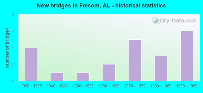
- New bridges - historical statistics
- 41930-1939
- 11940-1949
- 11950-1959
- 21960-1969
- 51970-1979
- 31980-1989
- 61990-1999


- Bridge Condition - Deck
- 7.7%Very good
- 23.1%Good
- 38.5%Satisfactory
- 30.8%Fair

- Bridge Condition - Superstructure
- 15.4%Very good
- 23.1%Good
- 15.4%Satisfactory
- 38.5%Fair
- 7.7%Serious

- Bridge Condition - Substructure
- 15.4%Very good
- 15.4%Good
- 23.1%Satisfactory
- 38.5%Fair
- 7.7%Serious

- Bridge Condition - Channel
- 4.5%Very good
- 36.4%Good
- 54.5%Satisfactory
- 4.5%Fair

- Bridge Condition - Culverts
- 33.3%Very good
- 33.3%Good
- 22.2%Satisfactory
- 11.1%Fair
Find on map >> Show street view
Structure Number: 954, Location: 1 MI NORTH NEWELL (Lat: 33.446000, Lng: -85.437000), Route carried "on" structure: County highway , Year Built: 1932, Status: Posted for load, Structure Length: 0.94m (3.08ft), Average Daily Traffic: 50 (year 1997), Average Future Daily Traffic: 126 (year 2035), Design Load: H 10, Features Intersected: COHOBADIAH CREEK, Facility Carried by Structure: CO RD 417
Minimum Vertical Clearance: 7.56m (24.80ft), Kilometerpoint: 0.010, Lanes on structure: 1, Owner: County Highway Agency, Approaching Roadway Width: 5.5m (18.0ft), Material/Design: Steel, Design/Construction: Stringer/Multi-beam, Number Of Spans In Main Unit: 1, Length of Maximum Span: 9.4m (30.8ft), Curb-To-Curb Width: 4.0m (13.1ft), Out-to-Out Width: 4.0m (13.1ft)
Condition: Deck: Satisfactory, Superstructure: Serious, Substructure: Serious, Channel: Satisfactory, Operating Rating: 2.7 metric tons, Method Used To Determine Operating Rating: Allowable Stress (AS), Inventory Rating: 1.8 metric tons, Method Used To Determine Inventory Rating: Allowable Stress (AS), Structural Evaluation: High priority of replacement, Deck Geometry: Somewhat better than minimum adequacy, Waterway Adequacy: Equal to present minimum criteria, Approach Roadway Alignment: Equal to present minimum criteria, Bridge Posting: Required (Relationship of Operating Rating to Maximum Legal Load: > 39.9% below), Length Of Structure Improvement: 1.62m (5.31ft), Designated Inspection Frequency: Every 24 months, Other Special Inspection Frequency: Every 3 months, Inspection Date: June 2021, Other Special Inspection Date: December 2021, Bridge Improvement Cost: $144,000, Roadway Improvement Cost: $14,000, Total Project Cost: $158,000 ( Estimate for 2022), Deck Structure Type: Wood or Timber, Wearing Surface/Protective System: Wearing Surface: Wood or Timber
Find on map >> Show street view
Structure Number: 1617, Location: 9.8 MI W JCT I65 * US278 (Lat: 34.204358, Lng: -87.023031), Route carried "on" structure: US 278, Year Built: 1937, Status: Open, Structure Length: 9.14m (29.99ft), Average Daily Traffic: 5,014 (year 2020), Truck Traffic: 6%, Average Future Daily Traffic: 7,020 (year 2040), Design Load: H 15, Features Intersected: CROOKED CREEK
Minimum Vertical Clearance: 30+ m (98+ ft), Kilometerpoint: 108.684, Lanes on structure: 2, Owner: State Highway Agency, Approaching Roadway Width: 8.5m (27.9ft), Material/Design: Steel, Design/Construction: Stringer/Multi-beam, Number Of Spans In Main Unit: 3, Number Of Approach Spans: 4, Length of Maximum Span: 18.3m (60.0ft), Curb or Sidewalk Widths: Left: 0.1m (0.3ft), Right: 0.1m (0.3ft), Curb-To-Curb Width: 7.3m (24.0ft), Out-to-Out Width: 8.3m (27.2ft)
Condition: Deck: Fair, Superstructure: Fair, Substructure: Fair, Channel: Fair, Operating Rating: 47.1 metric tons, Method Used To Determine Operating Rating: Allowable Stress (AS), Inventory Rating: 29.8 metric tons, Method Used To Determine Inventory Rating: Allowable Stress (AS), Structural Evaluation: Somewhat better than minimum adequacy, Deck Geometry: High priority of replacement, Waterway Adequacy: Equal to present desirable criteria, Approach Roadway Alignment: Better than present minimum criteria, Length Of Structure Improvement: 10.11m (33.17ft), Designated Inspection Frequency: Every 24 months, Inspection Date: January 2022, Bridge Improvement Cost: $1,871,000, Roadway Improvement Cost: $187,000, Total Project Cost: $2,058,000 ( Estimate for 2022), Deck Structure Type: Concrete Cast-file-Place
Find on map >> Show street view
Structure Number: 1701, Location: FOSTER(WOOD)2.0MI NE (Lat: 33.434500, Lng: -85.588800), Route carried "on" structure: County highway , Year Built: 1938, Status: Posted for load, Structure Length: 1.16m (3.81ft), Average Daily Traffic: 35 (year 1991), Average Future Daily Traffic: 75 (year 2030), Features Intersected: BUCKANNON CREEK, Facility Carried by Structure: CO RD 269
Minimum Vertical Clearance: 30+ m (98+ ft), Kilometerpoint: 0.010, Lanes on structure: 1, Owner: County Highway Agency, Approaching Roadway Width: 6.1m (20.0ft), Material/Design: Steel, Design/Construction: Stringer/Multi-beam, Number Of Spans In Main Unit: 1, Length of Maximum Span: 11.6m (38.1ft), Curb-To-Curb Width: 4.3m (14.1ft), Out-to-Out Width: 4.3m (14.1ft)
Condition: Deck: Fair, Superstructure: Satisfactory, Substructure: Fair, Channel: Good, Operating Rating: 24.4 metric tons, Method Used To Determine Operating Rating: Load Factor (LF), Inventory Rating: 18.4 metric tons, Method Used To Determine Inventory Rating: Load Factor (LF), Structural Evaluation: Somewhat better than minimum adequacy, Deck Geometry: Equal to present minimum criteria, Waterway Adequacy: Equal to present minimum criteria, Approach Roadway Alignment: High priority of replacement, Bridge Posting: Required (Relationship of Operating Rating to Maximum Legal Load: 20.0 - 29.9% below), Length Of Structure Improvement: 1.84m (6.04ft), Designated Inspection Frequency: Every 24 months, Other Special Inspection Frequency: Every 6 months, Inspection Date: September 2020, Other Special Inspection Date: September 2021, Bridge Improvement Cost: $176,000, Roadway Improvement Cost: $18,000, Total Project Cost: $194,000 ( Estimate for 2022), Deck Structure Type: Wood or Timber, Wearing Surface/Protective System: Wearing Surface: Wood or Timber
Find on map >> Show street view
Structure Number: 1702, Location: 2.3MI E CAVER CR CHURCH (Lat: 33.401000, Lng: -85.448700), Route carried "on" structure: County highway , Year Built: 1938, Status: Posted for load, Structure Length: 1.13m (3.71ft), Average Daily Traffic: 73 (year 1990), Average Future Daily Traffic: 105 (year 2030), Features Intersected: WOLF CREEK, Facility Carried by Structure: CO RD 532
Minimum Vertical Clearance: 30+ m (98+ ft), Kilometerpoint: 0.010, Lanes on structure: 1, Owner: County Highway Agency, Approaching Roadway Width: 4.9m (16.1ft), Material/Design: Steel, Design/Construction: Stringer/Multi-beam, Number Of Spans In Main Unit: 1, Length of Maximum Span: 11.3m (37.1ft), Curb-To-Curb Width: 3.7m (12.1ft), Out-to-Out Width: 3.7m (12.1ft)
Condition: Deck: Satisfactory, Superstructure: Fair, Substructure: Fair, Channel: Good, Operating Rating: 14.6 metric tons, Method Used To Determine Operating Rating: Load Factor (LF), Inventory Rating: 10.3 metric tons, Method Used To Determine Inventory Rating: Load Factor (LF), Structural Evaluation: High priority of replacement, Deck Geometry: Meets minimum limits, Waterway Adequacy: Equal to present minimum criteria, Approach Roadway Alignment: Equal to present minimum criteria, Bridge Posting: Required (Relationship of Operating Rating to Maximum Legal Load: > 39.9% below), Length Of Structure Improvement: 1.80m (5.91ft), Designated Inspection Frequency: Every 24 months, Other Special Inspection Frequency: Every 12 months, Inspection Date: June 2021, Other Special Inspection Date: June 2021, Bridge Improvement Cost: $148,000, Roadway Improvement Cost: $15,000, Total Project Cost: $163,000 ( Estimate for 2022), Deck Structure Type: Wood or Timber, Wearing Surface/Protective System: Wearing Surface: Wood or Timber
Find on map >> Show street view
Structure Number: 3487, Location: 1MI E FOSTERS X RD (Lat: 33.421400, Lng: -85.538200), Route carried "on" structure: County highway 82, Year Built: 1949, Status: Posted for load, Structure Length: 6.22m (20.41ft), Average Daily Traffic: 420 (year 1990), Truck Traffic: 30%, Average Future Daily Traffic: 581 (year 2035), Design Load: H 15, Features Intersected: PINEY WOOD CREEK
Minimum Vertical Clearance: 30+ m (98+ ft), Kilometerpoint: 7.649, Lanes on structure: 2, Owner: County Highway Agency, Approaching Roadway Width: 7.3m (24.0ft), Material/Design: Concrete, Design/Construction: Tee Beam, Number Of Spans In Main Unit: 6, Length of Maximum Span: 10.4m (34.1ft), Curb-To-Curb Width: 6.6m (21.7ft), Out-to-Out Width: 7.6m (24.9ft)
Condition: Deck: Satisfactory, Superstructure: Good, Substructure: Satisfactory, Channel: Satisfactory, Operating Rating: 36.0 metric tons, Method Used To Determine Operating Rating: Load Factor (LF), Inventory Rating: 21.6 metric tons, Method Used To Determine Inventory Rating: Load Factor (LF), Structural Evaluation: Equal to present minimum criteria, Deck Geometry: High priority of corrective action, Waterway Adequacy: Equal to present minimum criteria, Approach Roadway Alignment: Better than present minimum criteria, Bridge Posting: Required (Relationship of Operating Rating to Maximum Legal Load: 10.0 - 19.9% below), Length Of Structure Improvement: 7.26m (23.82ft), Designated Inspection Frequency: Every 24 months, Other Special Inspection Frequency: Every 12 months, Inspection Date: March 2021, Other Special Inspection Date: March 2021, Bridge Improvement Cost: $1,195,000, Roadway Improvement Cost: $120,000, Total Project Cost: $1,315,000 ( Estimate for 2022), Deck Structure Type: Concrete Cast-file-Place, Wearing Surface/Protective System: Wearing Surface: Bituminous
Find on map >> Show street view
Structure Number: 3615, Location: 1.5MI EAST FOLSOM SCHOOL (Lat: 33.457900, Lng: -85.529200), Route carried "on" structure: ServiceCounty highway , Year Built: 1992, Status: Open, Structure Length: 0.91m (2.99ft), Average Daily Traffic: 20 (year 1997), Average Future Daily Traffic: 70 (year 2030), Design Load: HS 20, Features Intersected: PINEYWOOD CREEK, Facility Carried by Structure: CO RD 208
Minimum Vertical Clearance: 30+ m (98+ ft), Kilometerpoint: 0.010, Lanes on structure: 1, Owner: County Highway Agency, Approaching Roadway Width: 8.5m (27.9ft), Material/Design: Concrete, Design/Construction: Culvert, Number Of Spans In Main Unit: 2, Length of Maximum Span: 4.3m (14.1ft), Curb-To-Curb Width: 16.2m (53.1ft), Out-to-Out Width: 16.8m (55.1ft)
Condition: Channel: Good, Culverts: Very good, Operating Rating: 65.7 metric tons, Method Used To Determine Operating Rating: Load Factor (LF), Inventory Rating: 39.5 metric tons, Method Used To Determine Inventory Rating: Load Factor (LF), Structural Evaluation: Equal to present desirable criteria, Deck Geometry: Superior to present desirable criteria, Waterway Adequacy: Better than present minimum criteria, Approach Roadway Alignment: Better than present minimum criteria, Length Of Structure Improvement: 1.58m (5.18ft), Designated Inspection Frequency: Every 24 months, Inspection Date: March 2021, Bridge Improvement Cost: $730,000, Roadway Improvement Cost: $73,000, Total Project Cost: $803,000 ( Estimate for 2022), Deck Structure Type: Concrete Cast-file-Place, Wearing Surface/Protective System: Wearing Surface: Gravel
Find on map >> Show street view
Structure Number: 6697, Location: 0.6MI S CENTER WEST (Lat: 33.425000, Lng: -85.623300), Route carried "on" structure: County highway 113, Year Built: 1959, Status: Open, Structure Length: 1.31m (4.30ft), Average Daily Traffic: 135 (year 1991), Truck Traffic: 10%, Average Future Daily Traffic: 189 (year 2030), Design Load: HS 20, Features Intersected: LITTLE KETCHEPEDRAKEE CK
Minimum Vertical Clearance: 30+ m (98+ ft), Kilometerpoint: 3.479, Lanes on structure: 2, Owner: County Highway Agency, Approaching Roadway Width: 8.5m (27.9ft), Material/Design: Concrete, Design/Construction: Culvert, Number Of Spans In Main Unit: 4, Length of Maximum Span: 3.0m (9.8ft), Curb-To-Curb Width: 11.3m (37.1ft), Out-to-Out Width: 11.9m (39.0ft)
Condition: Channel: Satisfactory, Culverts: Satisfactory, Operating Rating: 54.7 metric tons, Method Used To Determine Operating Rating: Load Factor (LF), Inventory Rating: 32.8 metric tons, Method Used To Determine Inventory Rating: Load Factor (LF), Structural Evaluation: Equal to present minimum criteria, Deck Geometry: Superior to present desirable criteria, Waterway Adequacy: Better than present minimum criteria, Approach Roadway Alignment: Better than present minimum criteria, Length Of Structure Improvement: 1.98m (6.50ft), Designated Inspection Frequency: Every 24 months, Inspection Date: August 2020, Bridge Improvement Cost: $458,000, Roadway Improvement Cost: $46,000, Total Project Cost: $504,000 ( Estimate for 2022), Deck Structure Type: Concrete Cast-file-Place
Find on map >> Show street view
Structure Number: 7781, Location: SIMPSON CULVERT)W PINEHIL (Lat: 33.457000, Lng: -85.421900), Route carried "on" structure: County highway 92, Year Built: 1962, Status: Open, Structure Length: 1.16m (3.81ft), Average Daily Traffic: 250 (year 1997), Truck Traffic: 30%, Average Future Daily Traffic: 329 (year 2030), Design Load: H 10, Features Intersected: COHOBADIAH CREEK
Minimum Vertical Clearance: 7.56m (24.80ft), Kilometerpoint: 3.700, Lanes on structure: 2, Owner: County Highway Agency, Approaching Roadway Width: 7.9m (25.9ft), Material/Design: Concrete, Design/Construction: Culvert, Number Of Spans In Main Unit: 3, Length of Maximum Span: 3.7m (12.1ft), Curb-To-Curb Width: 17.7m (58.1ft), Out-to-Out Width: 18.3m (60.0ft)
Condition: Channel: Satisfactory, Culverts: Fair, Operating Rating: 88.9 metric tons, Method Used To Determine Operating Rating: Load Factor (LF), Inventory Rating: 79.0 metric tons, Method Used To Determine Inventory Rating: Load Factor (LF), Structural Evaluation: Somewhat better than minimum adequacy, Deck Geometry: Superior to present desirable criteria, Waterway Adequacy: Equal to present minimum criteria, Approach Roadway Alignment: Equal to present minimum criteria, Length Of Structure Improvement: 1.84m (6.04ft), Designated Inspection Frequency: Every 24 months, Inspection Date: April 2020, Bridge Improvement Cost: $636,000, Roadway Improvement Cost: $64,000, Total Project Cost: $700,000 ( Estimate for 2022), Deck Structure Type: Concrete Cast-file-Place, Wearing Surface/Protective System: Wearing Surface: Bituminous
Find on map >> Show street view
Structure Number: 8722, Location: 0.5MI S JORDAN CHAPEL (Lat: 33.450000, Lng: -85.497100), Route carried "on" structure: County highway 17, Year Built: 1965, Status: Open, Structure Length: 0.98m (3.22ft), Average Daily Traffic: 235 (year 1990), Truck Traffic: 15%, Average Future Daily Traffic: 329 (year 2030), Design Load: HS 20, Features Intersected: BRANCH, Facility Carried by Structure: C0. RD. 47
Minimum Vertical Clearance: 30+ m (98+ ft), Kilometerpoint: 1.080, Lanes on structure: 2, Owner: County Highway Agency, Approaching Roadway Width: 8.5m (27.9ft), Material/Design: Concrete, Design/Construction: Culvert, Number Of Spans In Main Unit: 3, Length of Maximum Span: 3.0m (9.8ft), Curb-To-Curb Width: 8.5m (27.9ft), Out-to-Out Width: 9.1m (29.9ft)
Condition: Channel: Satisfactory, Culverts: Good, Operating Rating: 61.4 metric tons, Method Used To Determine Operating Rating: Load Factor (LF), Inventory Rating: 32.7 metric tons, Method Used To Determine Inventory Rating: Load Factor (LF), Structural Evaluation: Better than present minimum criteria, Deck Geometry: Equal to present minimum criteria, Waterway Adequacy: Better than present minimum criteria, Approach Roadway Alignment: Better than present minimum criteria, Length Of Structure Improvement: 1.65m (5.41ft), Designated Inspection Frequency: Every 24 months, Inspection Date: June 2020, Bridge Improvement Cost: $382,000, Roadway Improvement Cost: $38,000, Total Project Cost: $420,000 ( Estimate for 2022), Deck Structure Type: Concrete Cast-file-Place, Wearing Surface/Protective System: Wearing Surface: Bituminous
Find on map >> Show street view
Structure Number: 11235, Location: 1.8MI S GOLD RIDGE (Lat: 33.470900, Lng: -85.377200), Route carried "on" structure: County highway 37, Year Built: 1974, Status: Posted for load, Structure Length: 1.55m (5.09ft), Average Daily Traffic: 320 (year 1990), Truck Traffic: 15%, Average Future Daily Traffic: 448 (year 2035), Features Intersected: KNOKES CREEK
Minimum Vertical Clearance: 30+ m (98+ ft), Kilometerpoint: 0.789, Lanes on structure: 2, Owner: County Highway Agency, Approaching Roadway Width: 8.5m (27.9ft), Material/Design: Steel, Design/Construction: Stringer/Multi-beam, Number Of Spans In Main Unit: 2, Length of Maximum Span: 7.6m (24.9ft), Curb or Sidewalk Widths: Left: 8.5m (27.9ft), Right: 8.5m (27.9ft), Curb-To-Curb Width: 7.3m (24.0ft), Out-to-Out Width: 7.3m (24.0ft)
Condition: Deck: Satisfactory, Superstructure: Satisfactory, Substructure: Satisfactory, Channel: Satisfactory, Operating Rating: 41.5 metric tons, Method Used To Determine Operating Rating: Load Factor (LF), Inventory Rating: 24.9 metric tons, Method Used To Determine Inventory Rating: Load Factor (LF), Structural Evaluation: Equal to present minimum criteria, Deck Geometry: Somewhat better than minimum adequacy, Waterway Adequacy: Equal to present minimum criteria, Approach Roadway Alignment: Better than present minimum criteria, Bridge Posting: Required (Relationship of Operating Rating to Maximum Legal Load: 10.0 - 19.9% below), Length Of Structure Improvement: 2.23m (7.32ft), Designated Inspection Frequency: Every 24 months, Other Special Inspection Frequency: Every 12 months, Inspection Date: March 2021, Other Special Inspection Date: March 2021, Bridge Improvement Cost: $368,000, Roadway Improvement Cost: $37,000, Total Project Cost: $405,000 ( Estimate for 2022), Deck Structure Type: Concrete Cast-file-Place
Find on map >> Show street view
Structure Number: 11475, Location: (FOSTER BR)WEST FOSTXRDS (Lat: 33.410600, Lng: -85.594700), Route carried "on" structure: County highway 82, Year Built: 1975, Status: Open, Structure Length: 14.20m (46.59ft), Average Daily Traffic: 310 (year 1990), Truck Traffic: 20%, Average Future Daily Traffic: 454 (year 2030), Design Load: HS 20, Features Intersected: TALLAPOOSA RIVER
Minimum Vertical Clearance: 30+ m (98+ ft), Kilometerpoint: 3.999, Lanes on structure: 2, Owner: County Highway Agency, Approaching Roadway Width: 8.5m (27.9ft), Material/Design: Steel, Design/Construction: Stringer/Multi-beam, Number Of Spans In Main Unit: 4, Number Of Approach Spans: 4, Length of Maximum Span: 30.5m (100.1ft), Curb-To-Curb Width: 6.6m (21.7ft), Out-to-Out Width: 7.2m (23.6ft)
Condition: Deck: Good, Superstructure: Good, Substructure: Satisfactory, Channel: Satisfactory, Operating Rating: 38.6 metric tons, Method Used To Determine Operating Rating: Load Factor (LF), Inventory Rating: 18.4 metric tons, Method Used To Determine Inventory Rating: Load Factor (LF), Structural Evaluation: Somewhat better than minimum adequacy, Waterway Adequacy: Better than present minimum criteria, Approach Roadway Alignment: Better than present minimum criteria, Length Of Structure Improvement: 15.00m (49.21ft), Designated Inspection Frequency: Every 24 months, Underwater Inspection Frequency: Every 48 months, Inspection Date: Febuary 2021, Underwater Inspection Date: July 2019, Bridge Improvement Cost: $2,365,000, Roadway Improvement Cost: $237,000, Total Project Cost: $2,602,000 ( Estimate for 2022), Deck Structure Type: Concrete Cast-file-Place
Find on map >> Show street view
Structure Number: 11479, Location: LEE BRIDGE (Lat: 33.438400, Lng: -85.610600), Route carried "on" structure: County highway 88, Year Built: 1975, Status: Open, Structure Length: 14.66m (48.10ft), Average Daily Traffic: 212 (year 1990), Truck Traffic: 21%, Average Future Daily Traffic: 297 (year 2030), Design Load: H 20, Features Intersected: TALLAPOOSA RIVER FAS 18
Minimum Vertical Clearance: 30+ m (98+ ft), Kilometerpoint: 0.010, Lanes on structure: 2, Owner: County Highway Agency, Approaching Roadway Width: 8.5m (27.9ft), Material/Design: Steel continuous, Design/Construction: Stringer/Multi-beam, Number Of Spans In Main Unit: 4, Number Of Approach Spans: 3, Length of Maximum Span: 32.0m (105.0ft), Curb-To-Curb Width: 7.3m (24.0ft), Out-to-Out Width: 7.3m (24.0ft)
Condition: Deck: Good, Superstructure: Good, Substructure: Good, Channel: Satisfactory, Operating Rating: 41.1 metric tons, Method Used To Determine Operating Rating: Load Factor (LF), Inventory Rating: 24.7 metric tons, Method Used To Determine Inventory Rating: Load Factor (LF), Structural Evaluation: Equal to present minimum criteria, Deck Geometry: Somewhat better than minimum adequacy, Waterway Adequacy: Better than present minimum criteria, Approach Roadway Alignment: Better than present minimum criteria, Length Of Structure Improvement: 15.44m (50.66ft), Designated Inspection Frequency: Every 24 months, Underwater Inspection Frequency: Every 48 months, Inspection Date: Febuary 2021, Underwater Inspection Date: July 2019, Bridge Improvement Cost: $2,541,000, Roadway Improvement Cost: $254,000, Total Project Cost: $2,795,000 ( Estimate for 2022), Deck Structure Type: Concrete Cast-file-Place
Find on map >> Show street view
Structure Number: 1195, Location: RICE MILL 3MI.S OF FOSTER (Lat: 33.389600, Lng: -85.516900), Route carried "on" structure: County highway , Year Built: 1978, Status: Posted for load, Structure Length: 1.34m (4.40ft), Average Daily Traffic: 25 (year 1997), Average Future Daily Traffic: 75 (year 2035), Design Load: H 10, Features Intersected: PINEYWOOD CREEK, Facility Carried by Structure: CO RD 270
Minimum Vertical Clearance: 30+ m (98+ ft), Kilometerpoint: 0.010, Lanes on structure: 1, Owner: County Highway Agency, Approaching Roadway Width: 4.3m (14.1ft), Material/Design: Steel, Design/Construction: Stringer/Multi-beam, Number Of Spans In Main Unit: 1, Length of Maximum Span: 13.4m (44.0ft), Curb-To-Curb Width: 4.0m (13.1ft), Out-to-Out Width: 4.3m (14.1ft)
Condition: Deck: Fair, Superstructure: Fair, Substructure: Fair, Channel: Satisfactory, Operating Rating: 5.4 metric tons, Method Used To Determine Operating Rating: Allowable Stress (AS), Inventory Rating: 3.6 metric tons, Method Used To Determine Inventory Rating: Allowable Stress (AS), Structural Evaluation: High priority of replacement, Deck Geometry: Somewhat better than minimum adequacy, Waterway Adequacy: Equal to present minimum criteria, Approach Roadway Alignment: Better than present minimum criteria, Bridge Posting: Required (Relationship of Operating Rating to Maximum Legal Load: > 39.9% below), Length Of Structure Improvement: 2.02m (6.63ft), Designated Inspection Frequency: Every 24 months, Other Special Inspection Frequency: Every 12 months, Inspection Date: March 2021, Other Special Inspection Date: March 2021, Bridge Improvement Cost: $194,000, Roadway Improvement Cost: $19,000, Total Project Cost: $213,000 ( Estimate for 2022), Deck Structure Type: Wood or Timber, Wearing Surface/Protective System: Wearing Surface: Wood or Timber
Find on map >> Show street view
Structure Number: 11952, Location: 1.4MI NE PINE HILL (Lat: 33.484200, Lng: -85.402300), Route carried "on" structure: County highway , Year Built: 1978, Status: Posted for load, Structure Length: 1.31m (4.30ft), Average Daily Traffic: 75 (year 1997), Average Future Daily Traffic: 70 (year 2030), Design Load: H 10, Features Intersected: KNAKES CREEK, Facility Carried by Structure: CO RD 429
Minimum Vertical Clearance: 30+ m (98+ ft), Kilometerpoint: 0.010, Lanes on structure: 1, Owner: County Highway Agency, Approaching Roadway Width: 5.5m (18.0ft), Material/Design: Steel, Design/Construction: Stringer/Multi-beam, Number Of Spans In Main Unit: 1, Length of Maximum Span: 13.1m (43.0ft), Curb-To-Curb Width: 3.5m (11.5ft), Out-to-Out Width: 3.5m (11.5ft)
Condition: Deck: Satisfactory, Superstructure: Fair, Substructure: Fair, Channel: Good, Operating Rating: 4.5 metric tons, Method Used To Determine Operating Rating: Allowable Stress (AS), Inventory Rating: 2.7 metric tons, Method Used To Determine Inventory Rating: Allowable Stress (AS), Structural Evaluation: High priority of replacement, Deck Geometry: High priority of corrective action, Waterway Adequacy: Better than present minimum criteria, Approach Roadway Alignment: Better than present minimum criteria, Bridge Posting: Required (Relationship of Operating Rating to Maximum Legal Load: 20.0 - 29.9% below), Length Of Structure Improvement: 1.98m (6.50ft), Designated Inspection Frequency: Every 24 months, Other Special Inspection Frequency: Every 12 months, Inspection Date: July 2021, Other Special Inspection Date: July 2021, Bridge Improvement Cost: $150,000, Roadway Improvement Cost: $15,000, Total Project Cost: $165,000 ( Estimate for 2022), Deck Structure Type: Wood or Timber, Wearing Surface/Protective System: Wearing Surface: Wood or Timber
Find on map >> Show street view
Structure Number: 12343, Location: .8 MI NE FOSTER BRIDGE (Lat: 33.418400, Lng: -85.591100), Route carried "on" structure: County highway , Year Built: 1980, Status: Open, Structure Length: 1.58m (5.18ft), Average Daily Traffic: 100 (year 1997), Average Future Daily Traffic: 125 (year 2030), Design Load: HS 20, Features Intersected: BUCKHANON CREEK, Facility Carried by Structure: CO RD 7
Minimum Vertical Clearance: 30+ m (98+ ft), Kilometerpoint: 0.010, Lanes on structure: 1, Owner: County Highway Agency, Approaching Roadway Width: 8.5m (27.9ft), Material/Design: Concrete, Design/Construction: Culvert, Number Of Spans In Main Unit: 4, Length of Maximum Span: 3.7m (12.1ft), Curb-To-Curb Width: 13.4m (44.0ft), Out-to-Out Width: 14.0m (45.9ft)
Condition: Channel: Satisfactory, Culverts: Satisfactory, Operating Rating: 57.5 metric tons, Method Used To Determine Operating Rating: Load Factor (LF), Inventory Rating: 34.5 metric tons, Method Used To Determine Inventory Rating: Load Factor (LF), Structural Evaluation: Equal to present minimum criteria, Deck Geometry: Superior to present desirable criteria, Waterway Adequacy: Better than present minimum criteria, Approach Roadway Alignment: Better than present minimum criteria, Length Of Structure Improvement: 2.26m (7.41ft), Designated Inspection Frequency: Every 24 months, Inspection Date: August 2020, Bridge Improvement Cost: $483,000, Roadway Improvement Cost: $48,000, Total Project Cost: $531,000 ( Estimate for 2022), Deck Structure Type: Concrete Cast-file-Place, Wearing Surface/Protective System: Wearing Surface: Epoxy Overlay
Find on map >> Show street view
Structure Number: 1256, Location: 0.3MI N CODRAN (Lat: 33.469100, Lng: -85.520700), Route carried "on" structure: County highway 19, Year Built: 1981, Status: Open, Structure Length: 0.94m (3.08ft), Average Daily Traffic: 315 (year 1990), Truck Traffic: 25%, Average Future Daily Traffic: 441 (year 2030), Design Load: H 10, Features Intersected: CREEK
Minimum Vertical Clearance: 30+ m (98+ ft), Kilometerpoint: 0.010, Lanes on structure: 2, Owner: County Highway Agency, Approaching Roadway Width: 7.3m (24.0ft), Material/Design: Concrete, Design/Construction: Culvert, Number Of Spans In Main Unit: 3, Length of Maximum Span: 3.0m (9.8ft), Curb-To-Curb Width: 5.8m (19.0ft), Out-to-Out Width: 5.9m (19.4ft)
Condition: Channel: Good, Culverts: Good, Operating Rating: 88.9 metric tons, Method Used To Determine Operating Rating: Load Factor (LF), Inventory Rating: 88.9 metric tons, Method Used To Determine Inventory Rating: Load Factor (LF), Structural Evaluation: Better than present minimum criteria, Deck Geometry: High priority of corrective action, Waterway Adequacy: Better than present minimum criteria, Approach Roadway Alignment: Better than present minimum criteria, Length Of Structure Improvement: 1.61m (5.28ft), Designated Inspection Frequency: Every 24 months, Inspection Date: June 2020, Bridge Improvement Cost: $409,000, Roadway Improvement Cost: $41,000, Total Project Cost: $450,000 ( Estimate for 2022), Deck Structure Type: Concrete Cast-file-Place
Find on map >> Show street view
Structure Number: 14492, Location: 1.4MI NE CENTER WESTCHURC (Lat: 33.451500, Lng: -85.620300), Route carried "on" structure: County highway , Year Built: 1989, Status: Open, Structure Length: 4.57m (14.99ft), Average Daily Traffic: 30 (year 1991), Average Future Daily Traffic: 42 (year 2030), Design Load: HS 20, Features Intersected: KETCHEPEDRAKE CREEK, Facility Carried by Structure: CO RD 201
Minimum Vertical Clearance: 30+ m (98+ ft), Kilometerpoint: 0.010, Lanes on structure: 2, Owner: County Highway Agency, Approaching Roadway Width: 7.3m (24.0ft), Material/Design: Prestressed concrete, Design/Construction: Stringer/Multi-beam, Number Of Spans In Main Unit: 3, Length of Maximum Span: 15.2m (49.9ft), Curb-To-Curb Width: 7.3m (24.0ft), Out-to-Out Width: 8.2m (26.9ft)
Condition: Deck: Good, Superstructure: Very good, Substructure: Very good, Channel: Good, Operating Rating: 68.0 metric tons, Method Used To Determine Operating Rating: Load Factor (LF), Inventory Rating: 40.7 metric tons, Method Used To Determine Inventory Rating: Load Factor (LF), Structural Evaluation: Equal to present desirable criteria, Deck Geometry: Equal to present minimum criteria, Waterway Adequacy: Equal to present desirable criteria, Approach Roadway Alignment: Equal to present desirable criteria, Length Of Structure Improvement: 5.56m (18.24ft), Designated Inspection Frequency: Every 24 months, Inspection Date: May 2021, Bridge Improvement Cost: $992,000, Roadway Improvement Cost: $99,000, Total Project Cost: $1,091,000 ( Estimate for 2022), Deck Structure Type: Concrete Cast-file-Place
Find on map >> Show street view
Structure Number: 1617, Location: 2 MI NW MORRISON X ROADS (Lat: 33.440600, Lng: -85.509600), Route carried "on" structure: County highway 19, Year Built: 1994, Status: Open, Structure Length: 0.98m (3.22ft), Average Daily Traffic: 250 (year 1997), Truck Traffic: 25%, Average Future Daily Traffic: 400 (year 2030), Design Load: HS 20, Features Intersected: PINEYWOOD CREEK
Minimum Vertical Clearance: 30+ m (98+ ft), Kilometerpoint: 0.010, Lanes on structure: 2, Owner: County Highway Agency, Approaching Roadway Width: 8.5m (27.9ft), Skew: 1 degrees, Material/Design: Concrete, Design/Construction: Culvert, Number Of Spans In Main Unit: 3, Length of Maximum Span: 3.0m (9.8ft), Curb-To-Curb Width: 11.6m (38.1ft), Out-to-Out Width: 12.2m (40.0ft)
Condition: Channel: Good, Culverts: Very good, Operating Rating: 88.9 metric tons, Method Used To Determine Operating Rating: Load Factor (LF), Inventory Rating: 70.4 metric tons, Method Used To Determine Inventory Rating: Load Factor (LF), Structural Evaluation: Equal to present desirable criteria, Deck Geometry: Superior to present desirable criteria, Waterway Adequacy: Equal to present desirable criteria, Approach Roadway Alignment: Better than present minimum criteria, Length Of Structure Improvement: 1.65m (5.41ft), Designated Inspection Frequency: Every 24 months, Inspection Date: June 2020, Bridge Improvement Cost: $382,000, Roadway Improvement Cost: $38,000, Total Project Cost: $420,000 ( Estimate for 2022), Deck Structure Type: Concrete Cast-file-Place, Wearing Surface/Protective System: Wearing Surface: Epoxy Overlay
Find on map >> Show street view
Structure Number: 16171, Location: HWY 113(FULLER CULVERT) (Lat: 33.379700, Lng: -85.618400), Route carried "on" structure: Business County highway 82, Year Built: 1994, Status: Open, Structure Length: 0.70m (2.30ft), Average Daily Traffic: 150 (year 1997), Truck Traffic: 25%, Average Future Daily Traffic: 175 (year 2030), Design Load: HS 20, Features Intersected: FULLER CREEK, Facility Carried by Structure: CO.RD. 113
Minimum Vertical Clearance: 30+ m (98+ ft), Kilometerpoint: 3.000, Lanes on structure: 2, Owner: County Highway Agency, Approaching Roadway Width: 9.8m (32.2ft), Material/Design: Concrete, Design/Construction: Culvert, Number Of Spans In Main Unit: 2, Length of Maximum Span: 3.0m (9.8ft), Curb-To-Curb Width: 26.8m (87.9ft), Out-to-Out Width: 27.4m (89.9ft)
Condition: Channel: Very good, Culverts: Good, Operating Rating: 88.9 metric tons, Method Used To Determine Operating Rating: Load Factor (LF), Inventory Rating: 88.9 metric tons, Method Used To Determine Inventory Rating: Load Factor (LF), Structural Evaluation: Better than present minimum criteria, Deck Geometry: Superior to present desirable criteria, Waterway Adequacy: Equal to present desirable criteria, Approach Roadway Alignment: Equal to present desirable criteria, Length Of Structure Improvement: 1.34m (4.40ft), Designated Inspection Frequency: Every 24 months, Inspection Date: August 2020, Bridge Improvement Cost: $232,000, Roadway Improvement Cost: $23,000, Total Project Cost: $255,000 ( Estimate for 2022), Deck Structure Type: Concrete Cast-file-Place, Wearing Surface/Protective System: Wearing Surface: Epoxy Overlay
Find on map >> Show street view
Structure Number: 16173, Location: 1.4 MI E MORRISON X ROADS (Lat: 33.433000, Lng: -85.473600), Route carried "on" structure: County highway 82, Year Built: 1993, Status: Open, Structure Length: 0.82m (2.69ft), Average Daily Traffic: 300 (year 1993), Truck Traffic: 10%, Average Future Daily Traffic: 700 (year 2030), Design Load: HS 20, Features Intersected: WOLF CREEK
Minimum Vertical Clearance: 30+ m (98+ ft), Kilometerpoint: 0.000, Lanes on structure: 2, Owner: County Highway Agency, Approaching Roadway Width: 8.5m (27.9ft), Skew: 1 degrees, Material/Design: Concrete, Design/Construction: Culvert, Number Of Spans In Main Unit: 2, Length of Maximum Span: 3.0m (9.8ft), Curb-To-Curb Width: 17.7m (58.1ft), Out-to-Out Width: 18.3m (60.0ft)
Condition: Channel: Good, Culverts: Very good, Operating Rating: 88.9 metric tons, Method Used To Determine Operating Rating: Load Factor (LF), Inventory Rating: 73.4 metric tons, Method Used To Determine Inventory Rating: Load Factor (LF), Structural Evaluation: Equal to present desirable criteria, Deck Geometry: Superior to present desirable criteria, Waterway Adequacy: Better than present minimum criteria, Approach Roadway Alignment: Better than present minimum criteria, Length Of Structure Improvement: 1.48m (4.86ft), Designated Inspection Frequency: Every 24 months, Inspection Date: May 2020, Bridge Improvement Cost: $512,000, Roadway Improvement Cost: $51,000, Total Project Cost: $563,000 ( Estimate for 2022), Deck Structure Type: Concrete Cast-file-Place, Wearing Surface/Protective System: Wearing Surface: Bituminous
Find on map >> Show street view
Structure Number: 16175, Location: 1.5 MI NW NEW HOPE CHURCH (Lat: 33.243200, Lng: -85.643300), Route carried "on" structure: ServiceCounty highway , Year Built: 1992, Status: Open, Structure Length: 4.63m (15.19ft), Average Daily Traffic: 400 (year 1997), Truck Traffic: 16%, Average Future Daily Traffic: 250 (year 2030), Design Load: HS 20, Features Intersected: CROOKED CREEK, Facility Carried by Structure: CO. RD. 857
Minimum Vertical Clearance: 30+ m (98+ ft), Kilometerpoint: 0.000, Lanes on structure: 2, Owner: County Highway Agency, Approaching Roadway Width: 8.5m (27.9ft), Material/Design: Prestressed concrete, Design/Construction: Stringer/Multi-beam, Number Of Spans In Main Unit: 3, Length of Maximum Span: 21.3m (69.9ft), Curb-To-Curb Width: 7.3m (24.0ft), Out-to-Out Width: 212.4m (696.9ft)
Condition: Deck: Very good, Superstructure: Very good, Substructure: Very good, Channel: Satisfactory, Operating Rating: 59.2 metric tons, Method Used To Determine Operating Rating: Load Factor (LF), Inventory Rating: 35.5 metric tons, Method Used To Determine Inventory Rating: Load Factor (LF), Structural Evaluation: Equal to present desirable criteria, Deck Geometry: Somewhat better than minimum adequacy, Waterway Adequacy: Equal to present minimum criteria, Approach Roadway Alignment: Equal to present minimum criteria, Length Of Structure Improvement: 5.63m (18.47ft), Designated Inspection Frequency: Every 24 months, Inspection Date: August 2020, Bridge Improvement Cost: $26,863,000, Roadway Improvement Cost: $2,686,000, Total Project Cost: $29,549,000 ( Estimate for 2022), Deck Structure Type: Concrete Cast-file-Place
Find on map >> Show street view
Structure Number: 16207, Location: 3 MI E CO. RD. 33 (Lat: 33.209400, Lng: -85.475900), Route carried "on" structure: ServiceCounty highway , Year Built: 1991, Status: Posted for load, Structure Length: 2.83m (9.28ft), Average Daily Traffic: 20 (year 1992), Average Future Daily Traffic: 75 (year 2030), Features Intersected: CORNHOUSE CREEK, Facility Carried by Structure: CO. RD. 821
Minimum Vertical Clearance: 30+ m (98+ ft), Kilometerpoint: 0.002, Lanes on structure: 1, Owner: County Highway Agency, Approaching Roadway Width: 5.5m (18.0ft), Skew: 2 degrees, Material/Design: Steel, Design/Construction: Stringer/Multi-beam, Number Of Spans In Main Unit: 2, Length of Maximum Span: 14.2m (46.6ft), Curb-To-Curb Width: 3.7m (12.1ft), Out-to-Out Width: 3.7m (12.1ft)
Condition: Deck: Fair, Superstructure: Fair, Substructure: Good, Channel: Satisfactory, Operating Rating: 13.5 metric tons, Method Used To Determine Operating Rating: Load Factor (LF), Inventory Rating: 8.8 metric tons, Method Used To Determine Inventory Rating: Load Factor (LF), Structural Evaluation: High priority of replacement, Deck Geometry: Meets minimum limits, Waterway Adequacy: Better than present minimum criteria, Approach Roadway Alignment: Better than present minimum criteria, Bridge Posting: Required (Relationship of Operating Rating to Maximum Legal Load: > 39.9% below), Length Of Structure Improvement: 3.76m (12.34ft), Designated Inspection Frequency: Every 24 months, Other Special Inspection Frequency: Every 3 months, Inspection Date: December 2021, Other Special Inspection Date: December 2021, Bridge Improvement Cost: $309,000, Roadway Improvement Cost: $31,000, Total Project Cost: $340,000 ( Estimate for 2022), Deck Structure Type: Concrete Cast-file-Place, Wearing Surface/Protective System: Wearing Surface: Gravel, Membrane: Built-up, Deck Protection: Epoxy Coated Reinforcing