Bridge Statistics for Enlow, Pennsylvania (PA)
Condition, Traffic, Stress, Structural Evaluation, Project Costs
- National Bridge Inventory (NBI) Statistics
- 28Number of bridges
- 190ft / 58.4mTotal length
- $2,530,000Total costs
- 436,625Total average daily traffic
- 25,406Total average daily truck traffic
- National Bridge Inventory (NBI) Registered Bridges for Enlow
- No street view available for this location
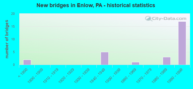
- New bridges - historical statistics
- 2Before 1900
- 51940-1949
- 11960-1969
- 31980-1989
- 171990-1999

- Reconstructed bridges - Historical Statistics
- 11970-1979
- 01980-1989
- 01990-1999
- 42000-2009
- 12010-2019


- Bridge Condition - Deck
- 25.0%Very good
- 50.0%Good
- 12.5%Satisfactory
- 12.5%Poor

- Bridge Condition - Superstructure
- 25.0%Very good
- 37.5%Good
- 12.5%Satisfactory
- 12.5%Fair
- 12.5%Poor

- Bridge Condition - Substructure
- 62.5%Good
- 25.0%Satisfactory
- 12.5%Fair

- Bridge Condition - Channel
- 28.6%Good
- 28.6%Satisfactory
- 14.3%Fair
- 28.6%Poor

- Bridge Condition - Culverts
- 50.0%Good
- 50.0%Fair
Find on map >> Show street view
Structure Number: 776, Location: MONTOUR RUN INTERCHANGE (Lat: 40.458092, Lng: -80.188692), Route carried "on" structure: Interstate 376, Year Built: 1949, Year Reconstructed: 2009, Status: Open, Structure Length: 9.27m (30.41ft), Average Daily Traffic: 74,750 (year 2022), Truck Traffic: 7%, Average Future Daily Traffic: 68,749 (year 2032), Design Load: HS 20, Features Intersected: CLIFFMINE RD, MONTOUR RN, Facility Carried by Structure: PARKWAY WEST
Minimum Vertical Clearance: 30+ m (98+ ft), Kilometerpoint: 15.010, Lanes on structure: 6, Lanes under structure: 4, Base Highway Network: Yes, Owner: State Highway Agency, Approaching Roadway Width: 25.6m (84.0ft), Skew: 31 degrees, Material/Design: Steel continuous, Design/Construction: Girder and Floorbeam System, Number Of Spans In Main Unit: 3, Length of Maximum Span: 31.7m (104.0ft), Curb or Sidewalk Widths: Left: 1.2m (3.9ft), Right: 0.2m (0.7ft), Curb-To-Curb Width: 25.6m (84.0ft), Out-to-Out Width: 29.3m (96.1ft)
Condition: Deck: Good, Superstructure: Satisfactory, Substructure: Satisfactory, Channel: Satisfactory, Operating Rating: 51.7 metric tons, Method Used To Determine Operating Rating: Load Factor (LF), Inventory Rating: 30.8 metric tons, Method Used To Determine Inventory Rating: Load Factor (LF), Structural Evaluation: Equal to present minimum criteria, Deck Geometry: Meets minimum limits, Underclear: Somewhat better than minimum adequacy, Waterway Adequacy: Superior to present desirable criteria, Approach Roadway Alignment: Equal to present desirable criteria, Length Of Structure Improvement: 9.30m (30.51ft), Designated Inspection Frequency: Every 24 months, Critical Feature Inspection Frequency: Every 24 months, Inspection Date: July 2021, Critical Feature Inspection Date: July 2021, Bridge Improvement Cost: $136,000, Roadway Improvement Cost: $402,000, Total Project Cost: $1,841,000, Deck Structure Type: Concrete Cast-file-Place, Wearing Surface/Protective System: Wearing Surface: Latex Concrete, Deck Protection: Epoxy Coated Reinforcing
Find on map >> Show street view
Structure Number: 2278, Location: 203001 .5 M WEST/SR 0060 (Lat: 40.464269, Lng: -80.202833), Route carried "on" structure: City street , Year Built: 1980, Year Reconstructed: 2016, Status: Open, Structure Length: 3.11m (10.20ft), Average Daily Traffic: 900 (year 2015), Truck Traffic: 5%, Average Future Daily Traffic: 1,010 (year 2039), Design Load: HL 93, Features Intersected: INDUSTRY DRIVE, Facility Carried by Structure: ATEN RD
Minimum Vertical Clearance: 30+ m (98+ ft), Kilometerpoint: 0.000, Lanes on structure: 2, Lanes under structure: 2, Owner: Town or Township Highway Agency, Approaching Roadway Width: 7.0m (23.0ft), Material/Design: Prestressed concrete, Design/Construction: Box Beam or Girders - Multiple, Number Of Spans In Main Unit: 1, Length of Maximum Span: 30.5m (100.1ft), Curb or Sidewalk Widths: Left: 0.2m (0.7ft), Right: 0.2m (0.7ft), Curb-To-Curb Width: 10.0m (32.8ft), Out-to-Out Width: 11.1m (36.4ft)
Condition: Deck: Satisfactory, Superstructure: Fair, Substructure: Satisfactory, Operating Rating: 61.2 metric tons, Method Used To Determine Operating Rating: Assigned ratings based on Load and Resistance Factor Design (LRFD) reported by rating factor (RF) using HL93 loadings, Inventory Rating: 40.2 metric tons, Method Used To Determine Inventory Rating: Assigned ratings based on Load and Resistance Factor Design (LRFD) reported by rating factor (RF) using HL93 loadings, Structural Evaluation: Somewhat better than minimum adequacy, Deck Geometry: Equal to present minimum criteria, Underclear: Equal to present minimum criteria, Approach Roadway Alignment: Better than present minimum criteria, Length Of Structure Improvement: 3.10m (10.17ft), Designated Inspection Frequency: Every 24 months, Other Special Inspection Frequency: Every 12 months, Inspection Date: May 2020, Other Special Inspection Date: May 2021, Deck Structure Type: Concrete Cast-file-Place, Wearing Surface/Protective System: Wearing Surface: Monolithic Concrete, Membrane: Other, Deck Protection: Epoxy Coated Reinforcing
Find on map >> Show street view
Structure Number: 2279, Location: MC07 MCCLARENS RUN # 7 (Lat: 40.475283, Lng: -80.212303), Route carried "on" structure: County highway , Year Built: 1940, Status: Posted for load, Structure Length: 0.73m (2.40ft), Average Daily Traffic: 944 (year 2006), Truck Traffic: 5%, Average Future Daily Traffic: 1,000 (year 2023), Design Load: HS 20, Features Intersected: MCCLARENS RUN, Facility Carried by Structure: COROAPOLIS IMPERIA
Minimum Vertical Clearance: 30+ m (98+ ft), Kilometerpoint: 0.000, Lanes on structure: 2, Owner: County Highway Agency, Approaching Roadway Width: 6.7m (22.0ft), Skew: 3 degrees, Material/Design: Steel, Design/Construction: Stringer/Multi-beam, Number Of Spans In Main Unit: 1, Length of Maximum Span: 6.1m (20.0ft), Curb-To-Curb Width: 10.1m (33.1ft), Out-to-Out Width: 10.5m (34.4ft)
Condition: Deck: Poor, Superstructure: Poor, Substructure: Fair, Channel: Poor, Operating Rating: 24.5 metric tons, Method Used To Determine Operating Rating: Load Factor (LF), Inventory Rating: 14.5 metric tons, Method Used To Determine Inventory Rating: Load Factor (LF), Structural Evaluation: Meets minimum limits, Deck Geometry: Equal to present minimum criteria, Waterway Adequacy: Better than present minimum criteria, Approach Roadway Alignment: Equal to present minimum criteria, Bridge Posting: Required (Relationship of Operating Rating to Maximum Legal Load: > 39.9% below), Length Of Structure Improvement: 1.50m (4.92ft), Designated Inspection Frequency: Every 24 months, Other Special Inspection Frequency: Every 12 months, Inspection Date: June 2020, Other Special Inspection Date: June 2021, Bridge Improvement Cost: $30,000, Roadway Improvement Cost: $88,000, Total Project Cost: $404,000, Deck Structure Type: Concrete Cast-file-Place, Wearing Surface/Protective System: Wearing Surface: Bituminous
Find on map >> Show street view
Structure Number: 2282, Location: MT04 MONTOUR RUN NO. 4 (Lat: 40.451875, Lng: -80.198611), Route carried "on" structure: County highway , Year Built: 1890, Year Reconstructed: 2014, Status: Open, Structure Length: 1.52m (4.99ft), Average Daily Traffic: 5,216 (year 2005), Truck Traffic: 5%, Average Future Daily Traffic: 6,000 (year 2022), Design Load: HL 93, Features Intersected: MONTOUR RUN, Facility Carried by Structure: STEUBENVL-ENLOW RD
Minimum Vertical Clearance: 30+ m (98+ ft), Kilometerpoint: 0.000, Lanes on structure: 2, Owner: County Highway Agency, Approaching Roadway Width: 9.8m (32.2ft), Material/Design: Prestressed concrete, Design/Construction: Box Beam or Girders - Single/Spread, Number Of Spans In Main Unit: 1, Length of Maximum Span: 14.3m (46.9ft), Curb or Sidewalk Widths: Left: 0.2m (0.7ft), Right: 0.2m (0.7ft), Curb-To-Curb Width: 9.8m (32.2ft), Out-to-Out Width: 10.8m (35.4ft)
Condition: Deck: Very good, Superstructure: Very good, Substructure: Good, Channel: Good, Operating Rating: 54.8 metric tons, Method Used To Determine Operating Rating: Assigned ratings based on Load and Resistance Factor Design (LRFD) reported by rating factor (RF) using HL93 loadings, Inventory Rating: 34.3 metric tons, Method Used To Determine Inventory Rating: Assigned ratings based on Load and Resistance Factor Design (LRFD) reported by rating factor (RF) using HL93 loadings, Structural Evaluation: Better than present minimum criteria, Deck Geometry: Meets minimum limits, Waterway Adequacy: Equal to present desirable criteria, Approach Roadway Alignment: Equal to present desirable criteria, Length Of Structure Improvement: 1.50m (4.92ft), Designated Inspection Frequency: Every 24 months, Inspection Date: April 2020, Bridge Improvement Cost: $7,000, Roadway Improvement Cost: $35,000, Total Project Cost: $95,000, Deck Structure Type: Concrete Cast-file-Place, Wearing Surface/Protective System: Wearing Surface: Monolithic Concrete, Deck Protection: Epoxy Coated Reinforcing
Find on map >> Show street view
Structure Number: 2283, Location: MT05 MONTOUR RUN NO. 5 (Lat: 40.451883, Lng: -80.204500), Route carried "on" structure: County highway , Year Built: 1883, Year Reconstructed: 2013, Status: Open, Structure Length: 1.77m (5.81ft), Average Daily Traffic: 5,321 (year 2010), Truck Traffic: 5%, Average Future Daily Traffic: 7,938 (year 2030), Design Load: HL 93, Features Intersected: MONTOUR RUN, Facility Carried by Structure: CLIFF MINE RD
Minimum Vertical Clearance: 30+ m (98+ ft), Kilometerpoint: 0.000, Lanes on structure: 2, Owner: County Highway Agency, Approaching Roadway Width: 9.8m (32.2ft), Skew: 3 degrees, Material/Design: Prestressed concrete, Design/Construction: Box Beam or Girders - Single/Spread, Number Of Spans In Main Unit: 1, Length of Maximum Span: 17.7m (58.1ft), Curb or Sidewalk Widths: Left: 0.2m (0.7ft), Right: 0.2m (0.7ft), Curb-To-Curb Width: 9.8m (32.2ft), Out-to-Out Width: 10.8m (35.4ft)
Condition: Deck: Very good, Superstructure: Very good, Substructure: Good, Channel: Satisfactory, Operating Rating: 47.6 metric tons, Method Used To Determine Operating Rating: Assigned ratings based on Load and Resistance Factor Design (LRFD) reported by rating factor (RF) using HL93 loadings, Inventory Rating: 36.9 metric tons, Method Used To Determine Inventory Rating: Assigned ratings based on Load and Resistance Factor Design (LRFD) reported by rating factor (RF) using HL93 loadings, Structural Evaluation: Better than present minimum criteria, Deck Geometry: Meets minimum limits, Waterway Adequacy: Equal to present desirable criteria, Approach Roadway Alignment: Equal to present desirable criteria, Length Of Structure Improvement: 1.80m (5.91ft), Designated Inspection Frequency: Every 24 months, Inspection Date: April 2020, Bridge Improvement Cost: $6,000, Roadway Improvement Cost: $25,000, Total Project Cost: $83,000, Deck Structure Type: Concrete Cast-file-Place, Wearing Surface/Protective System: Wearing Surface: Monolithic Concrete, Deck Protection: Epoxy Coated Reinforcing
Find on map >> Show street view
Structure Number: 2334, Location: MC01 MCCLARENS RUN # 1 (Lat: 40.458553, Lng: -80.190519), Route carried "on" structure: County highway , Year Built: 1949, Year Reconstructed: 1982, Status: Open, Structure Length: 1.55m (5.09ft), Average Daily Traffic: 23,000 (year 2013), Truck Traffic: 5%, Average Future Daily Traffic: 10,000 (year 2026), Design Load: HS 20, Features Intersected: MC CLARENS RUN, Facility Carried by Structure: CLIFF MINE RD
Minimum Vertical Clearance: 30+ m (98+ ft), Kilometerpoint: 0.000, Lanes on structure: 4, Owner: County Highway Agency, Approaching Roadway Width: 14.3m (46.9ft), Material/Design: Steel, Design/Construction: Stringer/Multi-beam, Number Of Spans In Main Unit: 1, Length of Maximum Span: 14.3m (46.9ft), Curb or Sidewalk Widths: Left: 0.8m (2.6ft), Right: 0.7m (2.3ft), Curb-To-Curb Width: 14.4m (47.2ft), Out-to-Out Width: 16.5m (54.1ft)
Condition: Deck: Good, Superstructure: Good, Substructure: Good, Channel: Good, Operating Rating: 45.4 metric tons, Method Used To Determine Operating Rating: Load Factor (LF), Inventory Rating: 27.2 metric tons, Method Used To Determine Inventory Rating: Load Factor (LF), Structural Evaluation: Equal to present minimum criteria, Deck Geometry: High priority of replacement, Waterway Adequacy: Equal to present desirable criteria, Approach Roadway Alignment: Equal to present desirable criteria, Length Of Structure Improvement: 1.60m (5.25ft), Designated Inspection Frequency: Every 24 months, Inspection Date: May 2021, Bridge Improvement Cost: $8,000, Roadway Improvement Cost: $50,000, Total Project Cost: $107,000, Deck Structure Type: Concrete Cast-file-Place, Wearing Surface/Protective System: Wearing Surface: Latex Concrete, Deck Protection: Epoxy Coated Reinforcing
Find on map >> Show street view
Structure Number: 2335, Location: MC06 MCCLARENS RUN # 6 (Lat: 40.474367, Lng: -80.211019), Route carried "on" structure: County highway , Year Built: 1983, Status: Open, Structure Length: 0.79m (2.59ft), Average Daily Traffic: 1,526 (year 2005), Truck Traffic: 3%, Average Future Daily Traffic: 1,700 (year 2025), Design Load: HS 20, Features Intersected: MC CLARENS RUN, Facility Carried by Structure: CORAOPOLIS IMP. RD
Minimum Vertical Clearance: 7.62m (25.00ft), Kilometerpoint: 0.000, Lanes on structure: 2, Owner: County Highway Agency, Approaching Roadway Width: 6.7m (22.0ft), Skew: 6 degrees, Material/Design: Steel, Design/Construction: Culvert, Number Of Spans In Main Unit: 1, Length of Maximum Span: 7.9m (25.9ft)
Condition: Channel: Fair, Culverts: Fair, Operating Rating: 53.5 metric tons, Method Used To Determine Operating Rating: Field evaluation and documented engineering judgment, Inventory Rating: 31.8 metric tons, Method Used To Determine Inventory Rating: Field evaluation and documented engineering judgment, Structural Evaluation: Somewhat better than minimum adequacy, Waterway Adequacy: Better than present minimum criteria, Approach Roadway Alignment: Equal to present desirable criteria, Length Of Structure Improvement: 0.80m (2.62ft), Designated Inspection Frequency: Every 24 months, Other Special Inspection Frequency: Every 12 months, Inspection Date: September 2021, Other Special Inspection Date: September 2021
Find on map >> Show street view
Structure Number: 2937, Location: INT 376 AND BUS 376 (Lat: 40.469000, Lng: -80.198606), Route carried "on" structure: Ramp State highway , Year Built: 1991, Status: Open, Structure Length: 28.35m (93.01ft), Average Daily Traffic: 1,424 (year 2021), Truck Traffic: 7%, Average Future Daily Traffic: 2,605 (year 2032), Design Load: HL 93, Features Intersected: SR 0376 & BUSINESS 376, Facility Carried by Structure: RAMP WS-C
Minimum Vertical Clearance: 30+ m (98+ ft), Kilometerpoint: 0.000, Lanes on structure: 1, Lanes under structure: 36, Base Highway Network: Yes, Owner: State Highway Agency, Approaching Roadway Width: 9.4m (30.8ft), Skew: 9 degrees, Material/Design: Steel continuous, Design/Construction: Stringer/Multi-beam, Number Of Spans In Main Unit: 5, Length of Maximum Span: 69.5m (228.0ft), Curb or Sidewalk Widths: Left: 0.2m (0.7ft), Right: 0.2m (0.7ft), Curb-To-Curb Width: 9.4m (30.8ft), Out-to-Out Width: 10.5m (34.4ft)
Condition: Deck: Good, Superstructure: Good, Substructure: Good, Operating Rating: 69.0 metric tons, Method Used To Determine Operating Rating: Load and Resistance Factor Rating (LRFR) rating reported by rating factor(RF) method using HL-93 loadings, Inventory Rating: 52.2 metric tons, Method Used To Determine Inventory Rating: Load and Resistance Factor Rating (LRFR) rating reported by rating factor(RF) method using HL-93 loadings, Structural Evaluation: Better than present minimum criteria, Deck Geometry: Superior to present desirable criteria, Underclear: Equal to present minimum criteria, Approach Roadway Alignment: Equal to present minimum criteria, Length Of Structure Improvement: 28.30m (92.85ft), Designated Inspection Frequency: Every 24 months, Inspection Date: October 2021, Deck Structure Type: Concrete Cast-file-Place, Wearing Surface/Protective System: Wearing Surface: Monolithic Concrete, Deck Protection: Epoxy Coated Reinforcing
Find on map >> Show street view
Structure Number: 294, Location: RAMP MT-B OVER SR 60 (Lat: 40.483333, Lng: -80.233333), Route carried "on" structure: Ramp State highway , Year Built: 1992, Year Reconstructed: 2005, Status: Open, Structure Length: 10.73m (35.20ft), Average Daily Traffic: 3,742 (year 2021), Truck Traffic: 6%, Average Future Daily Traffic: 7,777 (year 2032), Design Load: HL 93, Features Intersected: SR 0376 EB WB(RAMP MT-C), Facility Carried by Structure: RAMP MT-B
Minimum Vertical Clearance: 30+ m (98+ ft), Kilometerpoint: 0.000, Lanes on structure: 2, Lanes under structure: 18, Base Highway Network: Yes, Owner: State Highway Agency, Approaching Roadway Width: 14.6m (47.9ft), Skew: 9 degrees, Material/Design: Steel continuous, Design/Construction: Stringer/Multi-beam, Number Of Spans In Main Unit: 2, Length of Maximum Span: 63.1m (207.0ft), Curb or Sidewalk Widths: Left: 0.2m (0.7ft), Right: 0.2m (0.7ft), Curb-To-Curb Width: 14.8m (48.6ft), Out-to-Out Width: 15.7m (51.5ft)
Condition: Deck: Good, Superstructure: Good, Substructure: Good, Operating Rating: 73.9 metric tons, Method Used To Determine Operating Rating: Load and Resistance Factor Rating (LRFR) rating reported by rating factor(RF) method using HL-93 loadings, Inventory Rating: 57.0 metric tons, Method Used To Determine Inventory Rating: Load and Resistance Factor Rating (LRFR) rating reported by rating factor(RF) method using HL-93 loadings, Structural Evaluation: Better than present minimum criteria, Deck Geometry: Superior to present desirable criteria, Underclear: High priority of corrective action, Approach Roadway Alignment: Equal to present desirable criteria, Length Of Structure Improvement: 10.70m (35.10ft), Designated Inspection Frequency: Every 24 months, Inspection Date: October 2019, Deck Structure Type: Concrete Cast-file-Place, Wearing Surface/Protective System: Wearing Surface: Monolithic Concrete, Deck Protection: Epoxy Coated Reinforcing
Find on map >> Show street view
Structure Number: 40379, Location: MT14 MONTOUR RUN #14 (Lat: 40.451844, Lng: -80.205547), Route carried "on" structure: County highway , Year Built: 1998, Status: Open, Structure Length: 0.61m (2.00ft), Average Daily Traffic: 7,310 (year 2006), Truck Traffic: 5%, Average Future Daily Traffic: 8,500 (year 2023), Design Load: HS 25 or greater, Features Intersected: MONTOUR RUN, Facility Carried by Structure: CLIFF MINE RD
Minimum Vertical Clearance: 30+ m (98+ ft), Kilometerpoint: 0.000, Lanes on structure: 2, Owner: County Highway Agency, Approaching Roadway Width: 11.0m (36.1ft), Skew: 1 degrees, Material/Design: Concrete, Design/Construction: Culvert, Number Of Spans In Main Unit: 1, Length of Maximum Span: 6.1m (20.0ft), Curb-To-Curb Width: 11.0m (36.1ft), Out-to-Out Width: 11.9m (39.0ft)
Condition: Channel: Poor, Culverts: Good, Operating Rating: 61.7 metric tons, Method Used To Determine Operating Rating: Load Factor (LF), Inventory Rating: 37.2 metric tons, Method Used To Determine Inventory Rating: Load Factor (LF), Structural Evaluation: Better than present minimum criteria, Deck Geometry: Meets minimum limits, Waterway Adequacy: Better than present minimum criteria, Approach Roadway Alignment: Equal to present desirable criteria, Length Of Structure Improvement: 0.60m (1.97ft), Designated Inspection Frequency: Every 24 months, Inspection Date: April 2020
Find on map >> Show street view
Structure Number: 551, Location: OVER OAKDALE ROAD (Lat: 40.436683, Lng: -80.210425), Route carried "under" structure: State highway , Year Built: 1964, Structure Length: 0. m, Average Daily Traffic: 7,692 (year 2022), Truck Traffic: 2%, Features Intersected: OAKDALE ROAD SR 3063, Facility Carried by Structure: RT 0022 EB WB
Minimum Vertical Clearance: 4.34m (14.24ft), Kilometerpoint: 2.000, Lanes on structure: 5, Lanes under structure: 2, Material/Design: Steel, Design/Construction: Stringer/Multi-beam, Length of Maximum Span: 21.3m (69.9ft)
Find on map >> Show street view
Structure Number: 776, Location: MONTOUR RUN INTERCHANGE (Lat: 40.458092, Lng: -80.188692), Route carried "under" structure: State highway , Year Built: 1949, Structure Length: 0. m, Average Daily Traffic: 6,956 (year 2021), Truck Traffic: 7%, Features Intersected: CLIFFMINE RD, MONTOUR RN, Facility Carried by Structure: PARKWAY WEST
Minimum Vertical Clearance: 4.47m (14.67ft), Kilometerpoint: 0.000, Lanes on structure: 6, Lanes under structure: 2, Material/Design: Steel continuous, Design/Construction: Girder and Floorbeam System, Length of Maximum Span: 31.7m (104.0ft)
Find on map >> Show street view
Structure Number: 776, Location: MONTOUR RUN INTERCHANGE (Lat: 40.458092, Lng: -80.188692), Route carried "under" structure: State highway , Year Built: 1949, Structure Length: 0. m, Average Daily Traffic: 3,328 (year 2021), Truck Traffic: 8%, Features Intersected: CLIFFMINE RD, MONTOUR RN, Facility Carried by Structure: PARKWAY WEST
Minimum Vertical Clearance: 4.47m (14.67ft), Kilometerpoint: 0.000, Lanes on structure: 6, Lanes under structure: 2, Material/Design: Steel continuous, Design/Construction: Girder and Floorbeam System, Length of Maximum Span: 31.7m (104.0ft)
Find on map >> Show street view
Structure Number: 1828, Location: MCCLAREN RD EXIT (Lat: 40.471872, Lng: -80.221500), Route carried "under" structure: Ramp State highway , Year Built: 1991, Structure Length: 0. m, Average Daily Traffic: 2,399 (year 2021), Truck Traffic: 8%, Features Intersected: SR 0376 EB WB, Facility Carried by Structure: MCCLAREN RD
Minimum Vertical Clearance: 5.89m (19.32ft), Kilometerpoint: 0.000, Lanes on structure: 2, Lanes under structure: 6, Material/Design: Steel continuous, Design/Construction: Stringer/Multi-beam, Length of Maximum Span: 50.3m (165.0ft)
Find on map >> Show street view
Structure Number: 1828, Location: MCCLAREN RD EXIT (Lat: 40.471872, Lng: -80.221500), Route carried "under" structure: Interstate 376, Year Built: 1991, Structure Length: 0. m, Average Daily Traffic: 19,443 (year 2021), Truck Traffic: 10%, Features Intersected: SR 0376 EB WB, Facility Carried by Structure: MCCLAREN RD
Minimum Vertical Clearance: 6.12m (20.08ft), Kilometerpoint: 10.987, Lanes on structure: 2, Lanes under structure: 6, Material/Design: Steel continuous, Design/Construction: Stringer/Multi-beam, Length of Maximum Span: 50.3m (165.0ft)
Find on map >> Show street view
Structure Number: 1828, Location: MCCLAREN RD EXIT (Lat: 40.471872, Lng: -80.221500), Route carried "under" structure: Interstate 376, Year Built: 1991, Structure Length: 0. m, Average Daily Traffic: 20,813 (year 2021), Truck Traffic: 10%, Features Intersected: SR 0376 EB WB, Facility Carried by Structure: MCCLAREN RD
Minimum Vertical Clearance: 6.12m (20.08ft), Kilometerpoint: 10.932, Lanes on structure: 2, Lanes under structure: 6, Material/Design: Steel continuous, Design/Construction: Stringer/Multi-beam, Length of Maximum Span: 50.3m (165.0ft)
Find on map >> Show street view
Structure Number: 1891, Location: S. END OF AIRPORT EXPWY (Lat: 40.467331, Lng: -80.198347), Route carried "under" structure: Interstate 376, Year Built: 1991, Structure Length: 0. m, Average Daily Traffic: 29,457 (year 2022), Truck Traffic: 5%, Features Intersected: SR 376
Minimum Vertical Clearance: 5.61m (18.41ft), Kilometerpoint: 13.401, Lanes on structure: 2, Lanes under structure: 5, Material/Design: Steel continuous, Design/Construction: Stringer/Multi-beam, Length of Maximum Span: 64.0m (210.0ft)
Find on map >> Show street view
Structure Number: 1891, Location: S. END OF AIRPORT EXPWY (Lat: 40.467331, Lng: -80.198347), Route carried "under" structure: Interstate 376, Year Built: 1991, Structure Length: 0. m, Average Daily Traffic: 36,729 (year 2022), Truck Traffic: 6%, Features Intersected: SR 376
Minimum Vertical Clearance: 5.61m (18.41ft), Kilometerpoint: 13.372, Lanes on structure: 2, Lanes under structure: 5, Material/Design: Steel continuous, Design/Construction: Stringer/Multi-beam, Length of Maximum Span: 64.0m (210.0ft)
Find on map >> Show street view
Structure Number: 2278, Location: 203001 .5 M WEST/SR 0060 (Lat: 40.464269, Lng: -80.202833), Route carried "under" structure: City street , Year Built: 1980, Structure Length: 0. m, Average Daily Traffic: 200 (year 2005), Truck Traffic: 5%, Features Intersected: INDUSTRY DRIVE, Facility Carried by Structure: ATEN RD
Minimum Vertical Clearance: 4.85m (15.91ft), Kilometerpoint: 0.000, Lanes on structure: 2, Lanes under structure: 2, Material/Design: Prestressed concrete, Design/Construction: Box Beam or Girders - Multiple, Length of Maximum Span: 30.5m (100.1ft)
Find on map >> Show street view
Structure Number: 2937, Location: INT 376 AND BUS 376 (Lat: 40.469000, Lng: -80.198606), Route carried "under" structure: Business Interstate 376B, Year Built: 1991, Structure Length: 0. m, Average Daily Traffic: 15,925 (year 2022), Truck Traffic: 3%, Features Intersected: SR 0376 & BUSINESS 376, Facility Carried by Structure: RAMP WS-C
Minimum Vertical Clearance: 5.13m (16.83ft), Kilometerpoint: 10.472, Lanes on structure: 1, Lanes under structure: 9, Material/Design: Steel continuous, Design/Construction: Stringer/Multi-beam, Length of Maximum Span: 69.5m (228.0ft)
Find on map >> Show street view
Structure Number: 2937, Location: INT 376 AND BUS 376 (Lat: 40.469000, Lng: -80.198606), Route carried "under" structure: Interstate 376, Year Built: 1991, Structure Length: 0. m, Average Daily Traffic: 29,457 (year 2022), Truck Traffic: 5%, Features Intersected: SR 0376 & BUSINESS 376, Facility Carried by Structure: RAMP WS-C
Minimum Vertical Clearance: 9.35m (30.68ft), Kilometerpoint: 13.401, Lanes on structure: 1, Lanes under structure: 9, Material/Design: Steel continuous, Design/Construction: Stringer/Multi-beam, Length of Maximum Span: 69.5m (228.0ft)
Find on map >> Show street view
Structure Number: 2937, Location: INT 376 AND BUS 376 (Lat: 40.469000, Lng: -80.198606), Route carried "under" structure: Interstate 376, Year Built: 1991, Structure Length: 0. m, Average Daily Traffic: 36,729 (year 2022), Truck Traffic: 6%, Features Intersected: SR 0376 & BUSINESS 376, Facility Carried by Structure: RAMP WS-C
Minimum Vertical Clearance: 9.35m (30.68ft), Kilometerpoint: 13.372, Lanes on structure: 1, Lanes under structure: 9, Material/Design: Steel continuous, Design/Construction: Stringer/Multi-beam, Length of Maximum Span: 69.5m (228.0ft)
Find on map >> Show street view
Structure Number: 2937, Location: INT 376 AND BUS 376 (Lat: 40.469000, Lng: -80.198606), Route carried "under" structure: Business Interstate 376B, Year Built: 1991, Structure Length: 0. m, Average Daily Traffic: 13,218 (year 2022), Truck Traffic: 3%, Features Intersected: SR 0376 & BUSINESS 376, Facility Carried by Structure: RAMP WS-C
Minimum Vertical Clearance: 5.13m (16.83ft), Kilometerpoint: 10.206, Lanes on structure: 1, Lanes under structure: 9, Material/Design: Steel continuous, Design/Construction: Stringer/Multi-beam, Length of Maximum Span: 69.5m (228.0ft)
Find on map >> Show street view
Structure Number: 294, Location: RAMP MT-B OVER SR 60 (Lat: 40.483333, Lng: -80.233333), Route carried "under" structure: Interstate 376, Year Built: 1992, Structure Length: 0. m, Average Daily Traffic: 20,452 (year 2020), Truck Traffic: 6%, Features Intersected: SR 0376 EB WB(RAMP MT-C), Facility Carried by Structure: RAMP MT-B
Minimum Vertical Clearance: 6.34m (20.80ft), Kilometerpoint: 6.159, Lanes on structure: 2, Lanes under structure: 6, Material/Design: Steel continuous, Design/Construction: Stringer/Multi-beam, Length of Maximum Span: 63.1m (207.0ft)
Find on map >> Show street view
Structure Number: 294, Location: RAMP MT-B OVER SR 60 (Lat: 40.483333, Lng: -80.233333), Route carried "under" structure: Interstate 376, Year Built: 1992, Structure Length: 0. m, Average Daily Traffic: 22,027 (year 2020), Truck Traffic: 4%, Features Intersected: SR 0376 EB WB(RAMP MT-C), Facility Carried by Structure: RAMP MT-B
Minimum Vertical Clearance: 6.32m (20.73ft), Kilometerpoint: 6.159, Lanes on structure: 2, Lanes under structure: 6, Material/Design: Steel continuous, Design/Construction: Stringer/Multi-beam, Length of Maximum Span: 63.1m (207.0ft)
Find on map >> Show street view
Structure Number: 294, Location: RAMP MT-B OVER SR 60 (Lat: 40.483333, Lng: -80.233333), Route carried "under" structure: Ramp State highway , Year Built: 1992, Structure Length: 0. m, Average Daily Traffic: 5,188 (year 2021), Truck Traffic: 2%, Features Intersected: SR 0376 EB WB(RAMP MT-C), Facility Carried by Structure: RAMP MT-B
Minimum Vertical Clearance: 5.75m (18.86ft), Kilometerpoint: 0.000, Lanes on structure: 2, Lanes under structure: 6, Material/Design: Steel continuous, Design/Construction: Stringer/Multi-beam, Length of Maximum Span: 63.1m (207.0ft)
Find on map >> Show street view
Structure Number: 2942, Location: RAMP MT-C OVER I-376 (Lat: 40.483333, Lng: -80.233333), Route carried "under" structure: Interstate 376, Year Built: 1992, Structure Length: 0. m, Average Daily Traffic: 22,027 (year 2020), Truck Traffic: 4%, Features Intersected: SR 0376 EB WB, Facility Carried by Structure: RAMP MT-C
Minimum Vertical Clearance: 5.74m (18.83ft), Kilometerpoint: 6.159, Lanes on structure: 2, Lanes under structure: 4, Material/Design: Steel continuous, Design/Construction: Stringer/Multi-beam, Length of Maximum Span: 47.9m (157.2ft)
Find on map >> Show street view
Structure Number: 2942, Location: RAMP MT-C OVER I-376 (Lat: 40.483333, Lng: -80.233333), Route carried "under" structure: Interstate 376, Year Built: 1992, Structure Length: 0. m, Average Daily Traffic: 20,452 (year 2020), Truck Traffic: 6%, Features Intersected: SR 0376 EB WB, Facility Carried by Structure: RAMP MT-C
Minimum Vertical Clearance: 5.74m (18.83ft), Kilometerpoint: 6.159, Lanes on structure: 2, Lanes under structure: 4, Material/Design: Steel continuous, Design/Construction: Stringer/Multi-beam, Length of Maximum Span: 47.9m (157.2ft)