Bridge Statistics for Ellenboro, West Virginia (WV)
Condition, Traffic, Stress, Structural Evaluation, Project Costs
- National Bridge Inventory (NBI) Statistics
- 19Number of bridges
- 259ft / 79.5mTotal length
- $10,337,000Total costs
- 45,447Total average daily traffic
- 7,162Total average daily truck traffic
- National Bridge Inventory (NBI) Registered Bridges for Ellenboro
- No street view available for this location
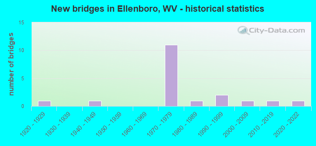
- New bridges - historical statistics
- 11920-1929
- 11940-1949
- 111970-1979
- 11980-1989
- 21990-1999
- 12000-2009
- 12010-2019
- 12020-2022


- Bridge Condition - Deck
- 15.4%Very good
- 38.5%Good
- 46.2%Fair

- Bridge Condition - Superstructure
- 7.7%Very good
- 53.8%Good
- 38.5%Fair

- Bridge Condition - Substructure
- 7.7%Very good
- 38.5%Good
- 15.4%Satisfactory
- 30.8%Fair
- 7.7%Poor

- Bridge Condition - Channel
- 16.7%Very good
- 75.0%Good
- 8.3%Fair
Find on map >> Show street view
Structure Number: 43A051, Location: 0.14 MILE SOUTH CR 50/39 (Lat: 39.265289, Lng: -81.056511), Route carried "on" structure: State highway 16, Year Built: 1993, Status: Open, Structure Length: 0.76m (2.49ft), Average Daily Traffic: 4,170 (year 2017), Truck Traffic: 9%, Average Future Daily Traffic: 5,296 (year 2037), Design Load: HS 20, Features Intersected: HUSHER'S RUN
Minimum Vertical Clearance: 30+ m (98+ ft), Kilometerpoint: 36.242, Lanes on structure: 2, Owner: State Highway Agency, Approaching Roadway Width: 7.9m (25.9ft), Skew: 1 degrees, Material/Design: Concrete continuous, Design/Construction: Culvert, Number Of Spans In Main Unit: 2, Length of Maximum Span: 3.7m (12.1ft)
Condition: Channel: Good, Culverts: Good, Operating Rating: 71.7 metric tons, Method Used To Determine Operating Rating: Field evaluation and documented engineering judgment, Inventory Rating: 32.7 metric tons, Method Used To Determine Inventory Rating: Field evaluation and documented engineering judgment, Structural Evaluation: Better than present minimum criteria, Waterway Adequacy: Equal to present desirable criteria, Approach Roadway Alignment: Equal to present desirable criteria, Length Of Structure Improvement: 0.76m (2.49ft), Designated Inspection Frequency: Every 48 months, Inspection Date: May 2019, Bridge Improvement Cost: $55,000, Total Project Cost: $55,000 ( Estimate for 2015)
Find on map >> Show street view
Structure Number: 43A052, Location: 0.02 M WEST OF CR 50/29 (Lat: 39.287989, Lng: -81.079719), Route carried "on" structure: County highway 164, Year Built: 1989, Status: Open, Structure Length: 1.94m (6.36ft), Average Daily Traffic: 90 (year 2019), Truck Traffic: 5%, Average Future Daily Traffic: 134 (year 2039), Design Load: HS 20, Features Intersected: BONDS CREEK, Facility Carried by Structure: COUNTY ROUTE 16/4
Minimum Vertical Clearance: 30+ m (98+ ft), Kilometerpoint: 0.113, Lanes on structure: 2, Owner: State Highway Agency, Approaching Roadway Width: 6.4m (21.0ft), Material/Design: Prestressed concrete, Design/Construction: Box Beam or Girders - Multiple, Number Of Spans In Main Unit: 1, Length of Maximum Span: 18.9m (62.0ft), Curb-To-Curb Width: 7.1m (23.3ft), Out-to-Out Width: 7.4m (24.3ft)
Condition: Deck: Good, Superstructure: Good, Substructure: Good, Channel: Very good, Operating Rating: 88.9 metric tons, Method Used To Determine Operating Rating: Load Factor (LF), Inventory Rating: 71.7 metric tons, Method Used To Determine Inventory Rating: Load Factor (LF), Structural Evaluation: Better than present minimum criteria, Deck Geometry: Somewhat better than minimum adequacy, Waterway Adequacy: Equal to present minimum criteria, Approach Roadway Alignment: Equal to present minimum criteria, Length Of Structure Improvement: 1.95m (6.40ft), Designated Inspection Frequency: Every 48 months, Inspection Date: November 2021, Bridge Improvement Cost: $1,000,000, Roadway Improvement Cost: $500,000, Total Project Cost: $1,500,000 ( Estimate for 2014), Deck Structure Type: Other, Wearing Surface/Protective System: Wearing Surface: Monolithic Concrete, Deck Protection: Epoxy Coated Reinforcing
Find on map >> Show street view
Structure Number: 43A108, Location: 0.43 MI. W. OF WV. 16 (Lat: 39.261281, Lng: -81.061789), Route carried "on" structure: US 50, Year Built: 1970, Status: Open, Structure Length: 16.10m (52.82ft), Average Daily Traffic: 4,950 (year 2018), Truck Traffic: 17%, Average Future Daily Traffic: 6,683 (year 2038), Design Load: HS 20, Features Intersected: CR 16/6, Hushers Run
Minimum Vertical Clearance: 30+ m (98+ ft), Kilometerpoint: 20.020, Lanes on structure: 2, Lanes under structure: 2, Base Highway Network: Yes, Owner: State Highway Agency, Approaching Roadway Width: 11.9m (39.0ft), Skew: 3 degrees, Material/Design: Steel continuous, Design/Construction: Stringer/Multi-beam, Number Of Spans In Main Unit: 3, Number Of Approach Spans: 2, Length of Maximum Span: 35.1m (115.2ft), Curb-To-Curb Width: 12.4m (40.7ft), Out-to-Out Width: 13.6m (44.6ft)
Condition: Deck: Fair, Superstructure: Good, Substructure: Fair, Channel: Good, Operating Rating: 61.7 metric tons, Method Used To Determine Operating Rating: Load Factor (LF), Inventory Rating: 36.3 metric tons, Method Used To Determine Inventory Rating: Load Factor (LF), Structural Evaluation: Somewhat better than minimum adequacy, Deck Geometry: Better than present minimum criteria, Underclear: Somewhat better than minimum adequacy, Waterway Adequacy: Superior to present desirable criteria, Approach Roadway Alignment: Better than present minimum criteria, Length Of Structure Improvement: 16.09m (52.79ft), Designated Inspection Frequency: Every 24 months, Other Special Inspection Frequency: Every 24 months, Inspection Date: July 2020, Other Special Inspection Date: July 2020, Bridge Improvement Cost: $695,000, Roadway Improvement Cost: $5,000, Total Project Cost: $700,000, Deck Structure Type: Concrete Cast-file-Place, Wearing Surface/Protective System: Wearing Surface: Latex Concrete
Find on map >> Show street view
Structure Number: 43A109, Location: 0.43 MI. W. OF WV.16 (Lat: 39.261789, Lng: -81.061219), Route carried "on" structure: US 50, Year Built: 1970, Status: Open, Structure Length: 16.18m (53.08ft), Average Daily Traffic: 4,950 (year 2018), Truck Traffic: 17%, Average Future Daily Traffic: 6,683 (year 2038), Design Load: HS 20, Features Intersected: CR. 16/6, Hushers Run
Minimum Vertical Clearance: 30+ m (98+ ft), Kilometerpoint: 20.020, Lanes on structure: 2, Lanes under structure: 2, Base Highway Network: Yes, Owner: State Highway Agency, Approaching Roadway Width: 11.3m (37.1ft), Skew: 13 degrees, Material/Design: Steel continuous, Design/Construction: Stringer/Multi-beam, Number Of Spans In Main Unit: 3, Number Of Approach Spans: 2, Length of Maximum Span: 35.1m (115.2ft), Curb-To-Curb Width: 12.3m (40.4ft), Out-to-Out Width: 13.6m (44.6ft)
Condition: Deck: Fair, Superstructure: Fair, Substructure: Poor, Channel: Good, Operating Rating: 61.7 metric tons, Method Used To Determine Operating Rating: Load Factor (LF), Inventory Rating: 37.2 metric tons, Method Used To Determine Inventory Rating: Load Factor (LF), Structural Evaluation: Meets minimum limits, Deck Geometry: Better than present minimum criteria, Underclear: High priority of corrective action, Waterway Adequacy: Superior to present desirable criteria, Approach Roadway Alignment: Equal to present desirable criteria, Length Of Structure Improvement: 16.18m (53.08ft), Designated Inspection Frequency: Every 24 months, Other Special Inspection Frequency: Every 24 months, Inspection Date: July 2020, Other Special Inspection Date: July 2020, Bridge Improvement Cost: $695,000, Roadway Improvement Cost: $5,000, Total Project Cost: $700,000, Deck Structure Type: Concrete Cast-file-Place, Wearing Surface/Protective System: Wearing Surface: Latex Concrete
Find on map >> Show street view
Structure Number: 43A11, Location: 0.31 MILE EAST OF CR 16/6 (Lat: 39.263700, Lng: -81.055439), Route carried "on" structure: US 50, Year Built: 1970, Status: Open, Structure Length: 4.94m (16.21ft), Average Daily Traffic: 4,750 (year 2019), Truck Traffic: 17%, Average Future Daily Traffic: 6,698 (year 2039), Design Load: HS 20, Features Intersected: WV RT. 16
Minimum Vertical Clearance: 30+ m (98+ ft), Kilometerpoint: 20.680, Lanes on structure: 2, Lanes under structure: 3, Base Highway Network: Yes, Owner: State Highway Agency, Approaching Roadway Width: 12.5m (41.0ft), Material/Design: Steel, Design/Construction: Stringer/Multi-beam, Number Of Spans In Main Unit: 1, Number Of Approach Spans: 2, Length of Maximum Span: 23.8m (78.1ft), Curb-To-Curb Width: 12.3m (40.4ft), Out-to-Out Width: 13.6m (44.6ft)
Condition: Deck: Fair, Superstructure: Fair, Substructure: Satisfactory, Operating Rating: 68.0 metric tons, Method Used To Determine Operating Rating: Load Factor (LF), Inventory Rating: 40.8 metric tons, Method Used To Determine Inventory Rating: Load Factor (LF), Structural Evaluation: Somewhat better than minimum adequacy, Deck Geometry: Better than present minimum criteria, Underclear: Meets minimum limits, Approach Roadway Alignment: Equal to present desirable criteria, Length Of Structure Improvement: 5.00m (16.40ft), Designated Inspection Frequency: Every 24 months, Inspection Date: September 2021, Bridge Improvement Cost: $816,000, Roadway Improvement Cost: $100,000, Total Project Cost: $916,000, Deck Structure Type: Concrete Cast-file-Place, Wearing Surface/Protective System: Wearing Surface: Latex Concrete
Find on map >> Show street view
Structure Number: 43A111, Location: 0.31 MILE EAST OF CR 16/6 (Lat: 39.263689, Lng: -81.055439), Route carried "on" structure: US 50, Year Built: 1970, Status: Open, Structure Length: 4.95m (16.24ft), Average Daily Traffic: 4,750 (year 2019), Truck Traffic: 17%, Average Future Daily Traffic: 6,698 (year 2039), Design Load: HS 20, Features Intersected: WV RT. 16
Minimum Vertical Clearance: 30+ m (98+ ft), Kilometerpoint: 20.680, Lanes on structure: 2, Lanes under structure: 2, Base Highway Network: Yes, Owner: State Highway Agency, Approaching Roadway Width: 11.3m (37.1ft), Material/Design: Steel, Design/Construction: Stringer/Multi-beam, Number Of Spans In Main Unit: 1, Number Of Approach Spans: 2, Length of Maximum Span: 23.8m (78.1ft), Curb-To-Curb Width: 12.3m (40.4ft), Out-to-Out Width: 13.6m (44.6ft)
Condition: Deck: Fair, Superstructure: Fair, Substructure: Satisfactory, Operating Rating: 76.2 metric tons, Method Used To Determine Operating Rating: Load Factor (LF), Inventory Rating: 45.4 metric tons, Method Used To Determine Inventory Rating: Load Factor (LF), Structural Evaluation: Somewhat better than minimum adequacy, Deck Geometry: Better than present minimum criteria, Underclear: Meets minimum limits, Approach Roadway Alignment: Better than present minimum criteria, Length Of Structure Improvement: 5.00m (16.40ft), Designated Inspection Frequency: Every 24 months, Inspection Date: October 2021, Bridge Improvement Cost: $816,000, Roadway Improvement Cost: $100,000, Total Project Cost: $916,000, Deck Structure Type: Concrete Cast-file-Place, Wearing Surface/Protective System: Wearing Surface: Latex Concrete
Find on map >> Show street view
Structure Number: 43A115, Location: 0.01 M NORTH OF CR 16/4 (Lat: 39.287900, Lng: -81.078611), Route carried "on" structure: State highway 16, Year Built: 1947, Status: Open, Structure Length: 1.77m (5.81ft), Average Daily Traffic: 2,600 (year 2018), Truck Traffic: 9%, Average Future Daily Traffic: 2,834 (year 2038), Design Load: HS 15, Features Intersected: BONDS CREEK
Minimum Vertical Clearance: 30+ m (98+ ft), Kilometerpoint: 39.992, Lanes on structure: 2, Owner: State Highway Agency, Approaching Roadway Width: 8.5m (27.9ft), Skew: 3 degrees, Material/Design: Concrete, Design/Construction: Tee Beam, Number Of Spans In Main Unit: 1, Length of Maximum Span: 17.1m (56.1ft), Curb or Sidewalk Widths: Left: 0.9m (3.0ft), Right: 0.9m (3.0ft), Curb-To-Curb Width: 7.9m (25.9ft), Out-to-Out Width: 10.4m (34.1ft)
Condition: Deck: Fair, Superstructure: Fair, Substructure: Fair, Channel: Good, Operating Rating: 54.4 metric tons, Method Used To Determine Operating Rating: Load Factor (LF), Inventory Rating: 32.7 metric tons, Method Used To Determine Inventory Rating: Load Factor (LF), Structural Evaluation: Somewhat better than minimum adequacy, Deck Geometry: High priority of corrective action, Waterway Adequacy: Superior to present desirable criteria, Approach Roadway Alignment: Better than present minimum criteria, Length Of Structure Improvement: 2.29m (7.51ft), Designated Inspection Frequency: Every 24 months, Inspection Date: August 2020, Bridge Improvement Cost: $1,400,000, Roadway Improvement Cost: $200,000, Total Project Cost: $1,600,000 ( Estimate for 2014), Deck Structure Type: Concrete Cast-file-Place, Wearing Surface/Protective System: Wearing Surface: Bituminous
Find on map >> Show street view
Structure Number: 43A128, Location: 0.01 MI. E. CR RTE 50/17 (Lat: 39.283250, Lng: -81.024961), Route carried "on" structure: County highway 5039, Year Built: 1925, Status: Open, Structure Length: 1.29m (4.23ft), Average Daily Traffic: 2,600 (year 2018), Truck Traffic: 5%, Average Future Daily Traffic: 2,834 (year 2038), Features Intersected: HUSHERS RUN, Facility Carried by Structure: COUNTY ROAD 50/39
Minimum Vertical Clearance: 30+ m (98+ ft), Kilometerpoint: 3.718, Lanes on structure: 2, Owner: State Highway Agency, Approaching Roadway Width: 8.8m (28.9ft), Material/Design: Concrete continuous, Design/Construction: Slab, Number Of Spans In Main Unit: 2, Length of Maximum Span: 6.3m (20.7ft), Curb-To-Curb Width: 8.9m (29.2ft), Out-to-Out Width: 10.2m (33.5ft)
Condition: Deck: Fair, Superstructure: Fair, Substructure: Fair, Channel: Fair, Operating Rating: 63.5 metric tons, Method Used To Determine Operating Rating: Field evaluation and documented engineering judgment, Inventory Rating: 29.0 metric tons, Method Used To Determine Inventory Rating: Field evaluation and documented engineering judgment, Structural Evaluation: Somewhat better than minimum adequacy, Deck Geometry: Meets minimum limits, Waterway Adequacy: Somewhat better than minimum adequacy, Approach Roadway Alignment: Better than present minimum criteria, Length Of Structure Improvement: 1.28m (4.20ft), Designated Inspection Frequency: Every 24 months, Inspection Date: November 2020, Bridge Improvement Cost: $700,000, Roadway Improvement Cost: $100,000, Total Project Cost: $800,000, Deck Structure Type: Concrete Cast-file-Place, Wearing Surface/Protective System: Wearing Surface: Bituminous
Find on map >> Show street view
Structure Number: 43A144, Location: 0.23 M NORTH OF WV 16 (Lat: 39.249450, Lng: -81.029119), Route carried "on" structure: County highway 169, Year Built: 1979, Status: Open, Structure Length: 1.08m (3.54ft), Average Daily Traffic: 100 (year 2018), Truck Traffic: 5%, Average Future Daily Traffic: 119 (year 2038), Design Load: HS 20, Features Intersected: STEWART RUN, Facility Carried by Structure: COUNTY ROUTE 16/9
Minimum Vertical Clearance: 30+ m (98+ ft), Kilometerpoint: 0.370, Lanes on structure: 2, Owner: State Highway Agency, Approaching Roadway Width: 3.7m (12.1ft), Skew: 3 degrees, Material/Design: Prestressed concrete, Design/Construction: Box Beam or Girders - Multiple, Number Of Spans In Main Unit: 1, Length of Maximum Span: 10.4m (34.1ft), Curb-To-Curb Width: 5.1m (16.7ft), Out-to-Out Width: 5.5m (18.0ft)
Condition: Deck: Good, Superstructure: Good, Substructure: Fair, Channel: Good, Operating Rating: 58.0 metric tons, Method Used To Determine Operating Rating: Load Factor (LF), Inventory Rating: 35.4 metric tons, Method Used To Determine Inventory Rating: Load Factor (LF), Structural Evaluation: Somewhat better than minimum adequacy, Deck Geometry: High priority of corrective action, Waterway Adequacy: Better than present minimum criteria, Approach Roadway Alignment: Equal to present minimum criteria, Length Of Structure Improvement: 1.10m (3.61ft), Designated Inspection Frequency: Every 24 months, Inspection Date: August 2020, Bridge Improvement Cost: $400,000, Roadway Improvement Cost: $50,000, Total Project Cost: $450,000, Deck Structure Type: Other, Wearing Surface/Protective System: Wearing Surface: Bituminous, Deck Protection: Epoxy Coated Reinforcing
Find on map >> Show street view
Structure Number: 43A186, Location: 0.10 MILE S OF CR 16/4 (Lat: 39.302561, Lng: -81.051161), Route carried "on" structure: County highway 1, Year Built: 2003, Status: Open, Structure Length: 2.92m (9.58ft), Average Daily Traffic: 500 (year 2019), Truck Traffic: 5%, Average Future Daily Traffic: 745 (year 2039), Design Load: HS 25 or greater, Features Intersected: BONDS CREEK
Minimum Vertical Clearance: 30+ m (98+ ft), Kilometerpoint: 3.283, Lanes on structure: 2, Owner: State Highway Agency, Approaching Roadway Width: 4.9m (16.1ft), Material/Design: Prestressed concrete, Design/Construction: Box Beam or Girders - Multiple, Number Of Spans In Main Unit: 1, Length of Maximum Span: 28.0m (91.9ft), Curb-To-Curb Width: 7.3m (24.0ft), Out-to-Out Width: 7.5m (24.6ft)
Condition: Deck: Very good, Superstructure: Good, Substructure: Good, Channel: Good, Operating Rating: 88.9 metric tons, Method Used To Determine Operating Rating: Load Factor (LF), Inventory Rating: 60.8 metric tons, Method Used To Determine Inventory Rating: Load Factor (LF), Structural Evaluation: Better than present minimum criteria, Deck Geometry: Meets minimum limits, Waterway Adequacy: Equal to present minimum criteria, Approach Roadway Alignment: Equal to present minimum criteria, Length Of Structure Improvement: 2.93m (9.61ft), Designated Inspection Frequency: Every 48 months, Inspection Date: October 2021, Bridge Improvement Cost: $1,000,000, Roadway Improvement Cost: $500,000, Total Project Cost: $1,500,000 ( Estimate for 2014), Deck Structure Type: Other, Wearing Surface/Protective System: Wearing Surface: Monolithic Concrete, Deck Protection: Epoxy Coated Reinforcing
Find on map >> Show street view
Structure Number: 43A188, Location: 0.49 Mi East of CR 50/29 (Lat: 39.288761, Lng: -81.070031), Route carried "on" structure: County highway 164, Year Built: 2012, Status: Open, Structure Length: 2.65m (8.69ft), Average Daily Traffic: 107 (year 2017), Truck Traffic: 7%, Average Future Daily Traffic: 136 (year 2037), Design Load: HL 93, Features Intersected: Bonds Creek, Facility Carried by Structure: County Route 16/4
Minimum Vertical Clearance: 30+ m (98+ ft), Kilometerpoint: 0.933, Lanes on structure: 2, Owner: State Highway Agency, Approaching Roadway Width: 6.4m (21.0ft), Skew: 1 degrees, Material/Design: Prestressed concrete, Design/Construction: Box Beam or Girders - Multiple, Number Of Spans In Main Unit: 1, Length of Maximum Span: 25.3m (83.0ft), Curb-To-Curb Width: 6.5m (21.3ft), Out-to-Out Width: 6.5m (21.3ft)
Condition: Deck: Good, Superstructure: Good, Substructure: Good, Channel: Good, Operating Rating: 49.9 metric tons, Method Used To Determine Operating Rating: Load and Resistance Factor (LRFR), Inventory Rating: 39.9 metric tons, Method Used To Determine Inventory Rating: Load and Resistance Factor (LRFR), Structural Evaluation: Better than present minimum criteria, Deck Geometry: Meets minimum limits, Waterway Adequacy: Equal to present minimum criteria, Approach Roadway Alignment: Equal to present minimum criteria, Length Of Structure Improvement: 2.65m (8.69ft), Designated Inspection Frequency: Every 48 months, Inspection Date: October 2018, Bridge Improvement Cost: $1,000,000, Roadway Improvement Cost: $200,000, Total Project Cost: $1,200,000 ( Estimate for 2014), Deck Structure Type: Other, Wearing Surface/Protective System: Wearing Surface: Monolithic Concrete, Deck Protection: Epoxy Coated Reinforcing
Find on map >> Show street view
Structure Number: 43A198, Location: 0.82 MI. E OF CR 8 (Lat: 39.258681, Lng: -81.106389), Route carried "on" structure: US 50, Year Built: 1970, Year Reconstructed: 2019, Status: Open, Structure Length: 11.01m (36.12ft), Average Daily Traffic: 4,950 (year 2019), Truck Traffic: 25%, Average Future Daily Traffic: 6,980 (year 2039), Design Load: HL 93, Features Intersected: Bonds Creek
Minimum Vertical Clearance: 30+ m (98+ ft), Kilometerpoint: 16.126, Lanes on structure: 2, Base Highway Network: Yes, Owner: State Highway Agency, Approaching Roadway Width: 13.1m (43.0ft), Skew: 2 degrees, Material/Design: Steel continuous, Design/Construction: Stringer/Multi-beam, Number Of Spans In Main Unit: 1, Number Of Approach Spans: 2, Length of Maximum Span: 42.1m (138.1ft), Curb-To-Curb Width: 12.7m (41.7ft), Out-to-Out Width: 13.5m (44.3ft)
Condition: Deck: Good, Superstructure: Good, Substructure: Good, Channel: Good, Operating Rating: 59.9 metric tons, Method Used To Determine Operating Rating: Load and Resistance Factor (LRFR), Inventory Rating: 46.3 metric tons, Method Used To Determine Inventory Rating: Load and Resistance Factor (LRFR), Structural Evaluation: Better than present minimum criteria, Deck Geometry: Better than present minimum criteria, Waterway Adequacy: Superior to present desirable criteria, Approach Roadway Alignment: Equal to present desirable criteria, Length Of Structure Improvement: 11.00m (36.09ft), Designated Inspection Frequency: Every 24 months, Inspection Date: July 2021, Deck Structure Type: Concrete Cast-file-Place
Find on map >> Show street view
Structure Number: 43A199, Location: 0.82 MI. E OF CR 8 (Lat: 39.258800, Lng: -81.106569), Route carried "on" structure: US 50, Year Built: 1970, Year Reconstructed: 2019, Status: Open, Structure Length: 11.03m (36.19ft), Average Daily Traffic: 4,950 (year 2019), Truck Traffic: 25%, Average Future Daily Traffic: 6,980 (year 2039), Design Load: HL 93, Features Intersected: Bonds Creek
Minimum Vertical Clearance: 30+ m (98+ ft), Kilometerpoint: 16.126, Lanes on structure: 2, Base Highway Network: Yes, Owner: State Highway Agency, Approaching Roadway Width: 12.8m (42.0ft), Skew: 2 degrees, Material/Design: Steel continuous, Design/Construction: Stringer/Multi-beam, Number Of Spans In Main Unit: 1, Number Of Approach Spans: 2, Length of Maximum Span: 42.1m (138.1ft), Curb-To-Curb Width: 12.7m (41.7ft), Out-to-Out Width: 13.4m (44.0ft)
Condition: Deck: Good, Superstructure: Good, Substructure: Good, Channel: Good, Operating Rating: 59.9 metric tons, Method Used To Determine Operating Rating: Load and Resistance Factor (LRFR), Inventory Rating: 46.3 metric tons, Method Used To Determine Inventory Rating: Load and Resistance Factor (LRFR), Structural Evaluation: Better than present minimum criteria, Deck Geometry: Better than present minimum criteria, Waterway Adequacy: Superior to present desirable criteria, Approach Roadway Alignment: Equal to present desirable criteria, Length Of Structure Improvement: 11.03m (36.19ft), Designated Inspection Frequency: Every 24 months, Inspection Date: July 2021, Deck Structure Type: Concrete Cast-file-Place
Find on map >> Show street view
Structure Number: 43A201, Location: 0.23 MILE WEST OF WV 16 (Lat: 39.282750, Lng: -81.084219), Route carried "on" structure: County highway 5034, Year Built: 2020, Status: Open, Structure Length: 2.86m (9.38ft), Average Daily Traffic: 600 (year 2019), Truck Traffic: 5%, Average Future Daily Traffic: 654 (year 2039), Design Load: HL 93, Features Intersected: Bonds Creek, Facility Carried by Structure: COUNTY ROUTE 50/34
Minimum Vertical Clearance: 30+ m (98+ ft), Kilometerpoint: 18.025, Lanes on structure: 2, Owner: State Highway Agency, Approaching Roadway Width: 6.1m (20.0ft), Skew: 3 degrees, Material/Design: Prestressed concrete, Design/Construction: Box Beam or Girders - Multiple, Number Of Spans In Main Unit: 1, Length of Maximum Span: 27.4m (89.9ft), Curb-To-Curb Width: 9.1m (29.9ft), Out-to-Out Width: 9.9m (32.5ft)
Condition: Deck: Very good, Superstructure: Very good, Substructure: Very good, Channel: Very good, Operating Rating: 53.5 metric tons, Method Used To Determine Operating Rating: Load and Resistance Factor (LRFR), Inventory Rating: 41.7 metric tons, Method Used To Determine Inventory Rating: Load and Resistance Factor (LRFR), Structural Evaluation: Equal to present desirable criteria, Deck Geometry: Equal to present minimum criteria, Waterway Adequacy: Equal to present desirable criteria, Approach Roadway Alignment: Equal to present desirable criteria, Length Of Structure Improvement: 2.86m (9.38ft), Designated Inspection Frequency: Every 24 months, Inspection Date: May 2021, Deck Structure Type: Concrete Cast-file-Place, Wearing Surface/Protective System: Deck Protection: Epoxy Coated Reinforcing
Find on map >> Show street view
Structure Number: 43A108, Location: 0.43 MI. W. OF WV. 16 (Lat: 39.925000, Lng: -81.210000), Route carried "under" structure: County highway 1606, Year Built: 1970, Structure Length: 0. m, Average Daily Traffic: 40 (year 0007), Features Intersected: CR 16/6, Hushers Run, Facility Carried by Structure: US 50 EBL
Minimum Vertical Clearance: 7.19m (23.59ft), Kilometerpoint: 3.524, Lanes on structure: 2, Lanes under structure: 2, Length of Maximum Span: 35.1m (115.2ft)
Find on map >> Show street view
Structure Number: 43A109, Location: 0.43 MI. W. OF WV.16 (Lat: 39.925000, Lng: -81.210000), Route carried "under" structure: ServiceCounty highway 1606, Year Built: 1970, Structure Length: 0. m, Average Daily Traffic: 40 (year 0007), Features Intersected: CR. 16/6, Hushers Run, Facility Carried by Structure: US 50 WBL
Minimum Vertical Clearance: 7.77m (25.49ft), Kilometerpoint: 3.541, Lanes on structure: 2, Lanes under structure: 2, Length of Maximum Span: 35.1m (115.2ft)
Find on map >> Show street view
Structure Number: 43A11, Location: 0.31 MILE EAST OF CR 16/6 (Lat: 39.263700, Lng: -81.055439), Route carried "under" structure: State highway 1600, Year Built: 1970, Structure Length: 0. m, Average Daily Traffic: 2,650 (year 2010), Truck Traffic: 11%, Features Intersected: WV RT. 16, Facility Carried by Structure: US 50 EBL
Minimum Vertical Clearance: 5.05m (16.57ft), Kilometerpoint: 36.371, Lanes on structure: 2, Lanes under structure: 3, Length of Maximum Span: 23.8m (78.1ft)
Find on map >> Show street view
Structure Number: 43A111, Location: 0.31 MILE EAST OF CR 16/6 (Lat: 39.263531, Lng: -81.055269), Route carried "under" structure: State highway 1600, Year Built: 1970, Structure Length: 0. m, Average Daily Traffic: 2,650 (year 2010), Truck Traffic: 11%, Features Intersected: WV RT. 16, Facility Carried by Structure: US 50 WBL
Minimum Vertical Clearance: 4.93m (16.17ft), Kilometerpoint: 36.371, Lanes on structure: 2, Lanes under structure: 2, Length of Maximum Span: 23.8m (78.1ft)
Find on map >> Show street view
Structure Number: 43A168, Location: 0.15 MILE SOUTH CR 50/39 (Lat: 39.265419, Lng: -81.056539), Route carried "under" structure: State highway 16, Year Built: 1994, Structure Length: 0. m, Features Intersected: WEST VIRGINIA 16, Facility Carried by Structure: PEDESTRIAN BRIDGE
Minimum Vertical Clearance: 5.33m (17.49ft), Kilometerpoint: 36.259, Lanes under structure: 2, Length of Maximum Span: 24.4m (80.1ft)