Bridge Statistics for Eastland, Texas (TX)
Condition, Traffic, Stress, Structural Evaluation, Project Costs
- National Bridge Inventory (NBI) Statistics
- 45Number of bridges
- 531ft / 162mTotal length
- $133,000Total costs
- 371,190Total average daily traffic
- 86,689Total average daily truck traffic
- National Bridge Inventory (NBI) Registered Bridges for Eastland
- No street view available for this location
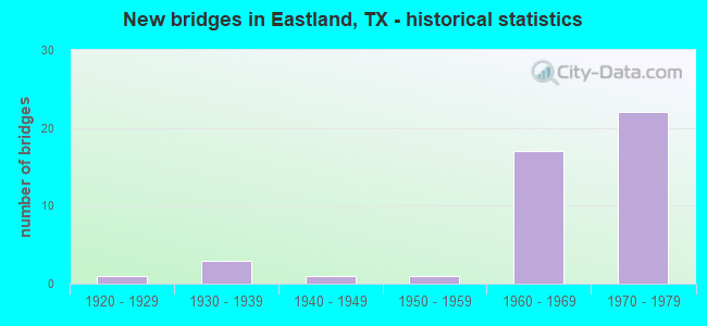
- New bridges - historical statistics
- 11920-1929
- 31930-1939
- 11940-1949
- 11950-1959
- 171960-1969
- 221970-1979

- Reconstructed bridges - Historical Statistics
- 21990-1999
- 12000-2009


- Bridge Condition - Deck
- 13.0%Very good
- 52.2%Good
- 34.8%Satisfactory

- Bridge Condition - Superstructure
- 8.7%Very good
- 69.6%Good
- 21.7%Satisfactory

- Bridge Condition - Substructure
- 56.5%Good
- 43.5%Satisfactory

- Bridge Condition - Channel
- 60.9%Good
- 34.8%Satisfactory
- 4.3%Fair

- Bridge Condition - Culverts
- 41.7%Good
- 50.0%Satisfactory
- 8.3%Fair
Find on map >> Show street view
Structure Number: 23068000070313, Location: 1.30 MI W OF SH 6 (Lat: 32.375372, Lng: -98.886611), Route carried "on" structure: Spur County highway 490, Year Built: 1969, Status: Open, Structure Length: 8.23m (27.00ft), Average Daily Traffic: 630 (year 2010), Average Future Daily Traffic: 750 (year 2030), Design Load: H 20, Features Intersected: IH 20
Minimum Vertical Clearance: 30+ m (98+ ft), Kilometerpoint: 13.197, Lanes on structure: 2, Lanes under structure: 4, Base Highway Network: Yes, Owner: State Highway Agency, Approaching Roadway Width: 8.5m (27.9ft), Material/Design: Prestressed concrete, Design/Construction: Stringer/Multi-beam, Number Of Spans In Main Unit: 2, Number Of Approach Spans: 2, Length of Maximum Span: 24.4m (80.1ft), Curb-To-Curb Width: 10.1m (33.1ft), Out-to-Out Width: 10.8m (35.4ft)
Condition: Deck: Good, Superstructure: Good, Substructure: Good, Operating Rating: 54.4 metric tons, Method Used To Determine Operating Rating: Load Factor (LF), Inventory Rating: 23.6 metric tons, Method Used To Determine Inventory Rating: Load Factor (LF), Structural Evaluation: Equal to present minimum criteria, Deck Geometry: Equal to present minimum criteria, Underclear: Somewhat better than minimum adequacy, Approach Roadway Alignment: Equal to present desirable criteria, Designated Inspection Frequency: Every 24 months, Inspection Date: Febuary 2020, Deck Structure Type: Concrete Cast-file-Place, Wearing Surface/Protective System: Wearing Surface: Bituminous
Find on map >> Show street view
Structure Number: 230680000703131, Location: 3.20 MI W OF SH 6 (Lat: 32.376411, Lng: -98.884731), Route carried "on" structure: ServiceInterstate 20, Year Built: 1969, Year Reconstructed: 2006, Status: Open, Structure Length: 0.70m (2.30ft), Average Daily Traffic: 470 (year 2013), Truck Traffic: 27%, Average Future Daily Traffic: 660 (year 2033), Design Load: HS 20, Features Intersected: DRAW
Minimum Vertical Clearance: 30+ m (98+ ft), Kilometerpoint: 21.660, Lanes on structure: 2, Base Highway Network: Yes, Owner: State Highway Agency, Approaching Roadway Width: 10.4m (34.1ft), Skew: 3 degrees, Material/Design: Concrete, Design/Construction: Culvert, Number Of Spans In Main Unit: 3, Length of Maximum Span: 1.8m (5.9ft), Curb-To-Curb Width: 10.4m (34.1ft), Out-to-Out Width: 16.6m (54.5ft)
Condition: Channel: Good, Culverts: Good, Operating Rating: 39.9 metric tons, Method Used To Determine Operating Rating: Load Factor (LF), Inventory Rating: 23.6 metric tons, Method Used To Determine Inventory Rating: Load Factor (LF), Structural Evaluation: Somewhat better than minimum adequacy, Deck Geometry: Equal to present minimum criteria, Waterway Adequacy: Equal to present minimum criteria, Approach Roadway Alignment: Equal to present desirable criteria, Designated Inspection Frequency: Every 24 months, Inspection Date: Febuary 2020
Find on map >> Show street view
Structure Number: 230680000703132, Location: 2.95 MI W OF SH 6 (Lat: 32.376089, Lng: -98.881064), Route carried "on" structure: Interstate 20, Year Built: 1969, Status: Open, Structure Length: 0.67m (2.20ft), Average Daily Traffic: 200 (year 2013), Truck Traffic: 48%, Average Future Daily Traffic: 10,500 (year 2033), Design Load: HS 20, Features Intersected: DRAW
Minimum Vertical Clearance: 30+ m (98+ ft), Kilometerpoint: 22.003, Lanes on structure: 2, Base Highway Network: Yes, Owner: State Highway Agency, Approaching Roadway Width: 6.1m (20.0ft), Material/Design: Concrete, Design/Construction: Culvert, Number Of Spans In Main Unit: 4, Length of Maximum Span: 1.5m (4.9ft)
Condition: Channel: Good, Culverts: Good, Operating Rating: 39.9 metric tons, Method Used To Determine Operating Rating: Load Factor (LF), Inventory Rating: 23.6 metric tons, Method Used To Determine Inventory Rating: Load Factor (LF), Structural Evaluation: Somewhat better than minimum adequacy, Waterway Adequacy: Equal to present minimum criteria, Approach Roadway Alignment: Equal to present desirable criteria, Designated Inspection Frequency: Every 24 months, Inspection Date: Febuary 2020
Find on map >> Show street view
Structure Number: 230680000703133, Location: 2.95 MI W OF SH 6 (Lat: 32.375389, Lng: -98.881114), Route carried "on" structure: Interstate 20, Year Built: 1969, Status: Open, Structure Length: 1.04m (3.41ft), Average Daily Traffic: 22,282 (year 2020), Truck Traffic: 19%, Average Future Daily Traffic: 39,040 (year 2033), Design Load: HS 20, Features Intersected: DRAW
Minimum Vertical Clearance: 30+ m (98+ ft), Kilometerpoint: 22.003, Lanes on structure: 6, Base Highway Network: Yes, Owner: State Highway Agency, Approaching Roadway Width: 37.5m (123.0ft), Skew: 20 degrees, Material/Design: Concrete, Design/Construction: Culvert, Number Of Spans In Main Unit: 5, Length of Maximum Span: 1.8m (5.9ft)
Condition: Channel: Good, Culverts: Good, Operating Rating: 39.9 metric tons, Method Used To Determine Operating Rating: Load Factor (LF), Inventory Rating: 23.6 metric tons, Method Used To Determine Inventory Rating: Load Factor (LF), Structural Evaluation: Somewhat better than minimum adequacy, Waterway Adequacy: Better than present minimum criteria, Approach Roadway Alignment: Equal to present desirable criteria, Designated Inspection Frequency: Every 24 months, Inspection Date: Febuary 2020
Find on map >> Show street view
Structure Number: 230680000703134, Location: 2.95 MI W OF SH 6 (Lat: 32.374886, Lng: -98.881058), Route carried "on" structure: ServiceInterstate 20, Year Built: 1969, Status: Open, Structure Length: 0.67m (2.20ft), Average Daily Traffic: 340 (year 2013), Truck Traffic: 27%, Average Future Daily Traffic: 480 (year 2033), Design Load: HS 20, Features Intersected: DRAW
Minimum Vertical Clearance: 30+ m (98+ ft), Kilometerpoint: 22.003, Lanes on structure: 2, Base Highway Network: Yes, Owner: State Highway Agency, Approaching Roadway Width: 6.7m (22.0ft), Material/Design: Concrete, Design/Construction: Culvert, Number Of Spans In Main Unit: 4, Length of Maximum Span: 1.5m (4.9ft)
Condition: Channel: Satisfactory, Culverts: Good, Operating Rating: 39.9 metric tons, Method Used To Determine Operating Rating: Load Factor (LF), Inventory Rating: 23.6 metric tons, Method Used To Determine Inventory Rating: Load Factor (LF), Structural Evaluation: Somewhat better than minimum adequacy, Waterway Adequacy: Equal to present minimum criteria, Approach Roadway Alignment: Equal to present desirable criteria, Designated Inspection Frequency: Every 24 months, Inspection Date: Febuary 2020
Find on map >> Show street view
Structure Number: 230680000703135, Location: 0.15 MI W OF SH 6 (Lat: 32.376156, Lng: -98.832414), Route carried "on" structure: ServiceInterstate 20, Year Built: 1969, Status: Open, Structure Length: 1.52m (4.99ft), Average Daily Traffic: 470 (year 2013), Truck Traffic: 27%, Average Future Daily Traffic: 660 (year 2033), Design Load: HS 20, Features Intersected: MIDDLE FORK LEON RIVER
Minimum Vertical Clearance: 30+ m (98+ ft), Kilometerpoint: 26.546, Lanes on structure: 2, Owner: State Highway Agency, Approaching Roadway Width: 11.6m (38.1ft), Skew: 3 degrees, Material/Design: Concrete, Design/Construction: Culvert, Number Of Spans In Main Unit: 4, Length of Maximum Span: 3.0m (9.8ft), Curb-To-Curb Width: 11.6m (38.1ft), Out-to-Out Width: 17.5m (57.4ft)
Condition: Channel: Satisfactory, Culverts: Satisfactory, Operating Rating: 39.9 metric tons, Method Used To Determine Operating Rating: Load Factor (LF), Inventory Rating: 23.6 metric tons, Method Used To Determine Inventory Rating: Load Factor (LF), Structural Evaluation: Equal to present minimum criteria, Deck Geometry: Better than present minimum criteria, Waterway Adequacy: Better than present minimum criteria, Approach Roadway Alignment: Equal to present desirable criteria, Designated Inspection Frequency: Every 24 months, Inspection Date: March 2020, Deck Structure Type: Concrete Cast-file-Place, Wearing Surface/Protective System: Wearing Surface: Bituminous
Find on map >> Show street view
Structure Number: 230680000703136, Location: 0.15 MI W OF SH 6 (Lat: 32.375964, Lng: -98.832314), Route carried "on" structure: Interstate 20, Year Built: 1969, Status: Open, Structure Length: 1.55m (5.09ft), Average Daily Traffic: 22,282 (year 2020), Truck Traffic: 37%, Average Future Daily Traffic: 35,372 (year 2038), Design Load: HS 20, Features Intersected: MIDDLE FORK LEON RIVER
Minimum Vertical Clearance: 30+ m (98+ ft), Kilometerpoint: 26.601, Lanes on structure: 4, Base Highway Network: Yes, Owner: State Highway Agency, Approaching Roadway Width: 23.2m (76.1ft), Skew: 23 degrees, Material/Design: Concrete, Design/Construction: Culvert, Number Of Spans In Main Unit: 4, Length of Maximum Span: 3.0m (9.8ft)
Condition: Channel: Good, Culverts: Satisfactory, Operating Rating: 39.9 metric tons, Method Used To Determine Operating Rating: Load Factor (LF), Inventory Rating: 23.6 metric tons, Method Used To Determine Inventory Rating: Load Factor (LF), Structural Evaluation: Somewhat better than minimum adequacy, Waterway Adequacy: Equal to present desirable criteria, Approach Roadway Alignment: Equal to present desirable criteria, Designated Inspection Frequency: Every 24 months, Inspection Date: March 2020
Find on map >> Show street view
Structure Number: 230680000703137, Location: 0.15 MI W OF SH 6 (Lat: 32.375750, Lng: -98.832228), Route carried "on" structure: ServiceInterstate 20, Year Built: 1969, Status: Open, Structure Length: 1.31m (4.30ft), Average Daily Traffic: 340 (year 2013), Truck Traffic: 27%, Average Future Daily Traffic: 480 (year 2033), Design Load: HS 20, Features Intersected: MIDDLE FORK LEON RIVER
Minimum Vertical Clearance: 30+ m (98+ ft), Kilometerpoint: 26.641, Lanes on structure: 2, Owner: State Highway Agency, Approaching Roadway Width: 11.6m (38.1ft), Material/Design: Concrete, Design/Construction: Culvert, Number Of Spans In Main Unit: 4, Length of Maximum Span: 3.0m (9.8ft), Curb-To-Curb Width: 11.9m (39.0ft), Out-to-Out Width: 17.5m (57.4ft)
Condition: Channel: Good, Culverts: Satisfactory, Operating Rating: 39.9 metric tons, Method Used To Determine Operating Rating: Load Factor (LF), Inventory Rating: 23.6 metric tons, Method Used To Determine Inventory Rating: Load Factor (LF), Structural Evaluation: Equal to present minimum criteria, Deck Geometry: Superior to present desirable criteria, Waterway Adequacy: Better than present minimum criteria, Approach Roadway Alignment: Equal to present desirable criteria, Designated Inspection Frequency: Every 24 months, Inspection Date: March 2020, Deck Structure Type: Concrete Cast-file-Place, Wearing Surface/Protective System: Wearing Surface: Bituminous
Find on map >> Show street view
Structure Number: 230680000703138, Location: 3.10 MI SW OF SH 112 (Lat: 32.376478, Lng: -98.830869), Route carried "on" structure: Interstate 20, Year Built: 1969, Status: Open, Structure Length: 6.25m (20.51ft), Average Daily Traffic: 13,094 (year 2019), Truck Traffic: 37%, Average Future Daily Traffic: 17,686 (year 2038), Design Load: HS 20, Features Intersected: SH 6
Minimum Vertical Clearance: 30+ m (98+ ft), Kilometerpoint: 26.726, Lanes on structure: 2, Lanes under structure: 2, Base Highway Network: Yes, Owner: State Highway Agency, Approaching Roadway Width: 12.2m (40.0ft), Skew: 2 degrees, Material/Design: Prestressed concrete, Design/Construction: Stringer/Multi-beam, Number Of Spans In Main Unit: 3, Length of Maximum Span: 22.9m (75.1ft), Curb-To-Curb Width: 12.2m (40.0ft), Out-to-Out Width: 12.9m (42.3ft)
Condition: Deck: Good, Superstructure: Good, Substructure: Good, Operating Rating: 54.4 metric tons, Method Used To Determine Operating Rating: Assigned ratings based on Allowable Stress Design (ASD) reported in metric tons, Inventory Rating: 32.7 metric tons, Method Used To Determine Inventory Rating: Assigned ratings based on Allowable Stress Design (ASD) reported in metric tons, Structural Evaluation: Better than present minimum criteria, Deck Geometry: Better than present minimum criteria, Underclear: Equal to present minimum criteria, Approach Roadway Alignment: Equal to present desirable criteria, Designated Inspection Frequency: Every 24 months, Inspection Date: Febuary 2020, Deck Structure Type: Concrete Cast-file-Place, Wearing Surface/Protective System: Wearing Surface: Bituminous
Find on map >> Show street view
Structure Number: 230680000703139, Location: 3.10 MI SW OF SH 112 (Lat: 32.376394, Lng: -98.830844), Route carried "on" structure: Interstate 20, Year Built: 1969, Status: Open, Structure Length: 6.25m (20.51ft), Average Daily Traffic: 13,416 (year 2019), Truck Traffic: 37%, Average Future Daily Traffic: 17,686 (year 2038), Design Load: HS 20, Features Intersected: SH 6
Minimum Vertical Clearance: 30+ m (98+ ft), Kilometerpoint: 26.718, Lanes on structure: 2, Lanes under structure: 2, Base Highway Network: Yes, Owner: State Highway Agency, Approaching Roadway Width: 12.2m (40.0ft), Skew: 2 degrees, Material/Design: Prestressed concrete, Design/Construction: Stringer/Multi-beam, Number Of Spans In Main Unit: 3, Length of Maximum Span: 22.9m (75.1ft), Curb-To-Curb Width: 12.2m (40.0ft), Out-to-Out Width: 12.9m (42.3ft)
Condition: Deck: Good, Superstructure: Good, Substructure: Satisfactory, Operating Rating: 54.4 metric tons, Method Used To Determine Operating Rating: Assigned ratings based on Allowable Stress Design (ASD) reported in metric tons, Inventory Rating: 32.7 metric tons, Method Used To Determine Inventory Rating: Assigned ratings based on Allowable Stress Design (ASD) reported in metric tons, Structural Evaluation: Equal to present minimum criteria, Deck Geometry: Better than present minimum criteria, Underclear: Better than present minimum criteria, Approach Roadway Alignment: Equal to present desirable criteria, Designated Inspection Frequency: Every 24 months, Inspection Date: Febuary 2020, Deck Structure Type: Concrete Cast-file-Place, Wearing Surface/Protective System: Wearing Surface: Bituminous
Find on map >> Show street view
Structure Number: 23068000070314, Location: 0.35 MI NE OF SH 6 (Lat: 32.378486, Lng: -98.824689), Route carried "on" structure: Interstate 20, Year Built: 1969, Status: Open, Structure Length: 7.32m (24.02ft), Average Daily Traffic: 12,408 (year 2019), Truck Traffic: 45%, Average Future Daily Traffic: 16,741 (year 2038), Design Load: HS 20, Features Intersected: SOUTH FORK LEON RIVER
Minimum Vertical Clearance: 30+ m (98+ ft), Kilometerpoint: 27.341, Lanes on structure: 2, Base Highway Network: Yes, Owner: State Highway Agency, Approaching Roadway Width: 12.2m (40.0ft), Material/Design: Concrete, Design/Construction: Stringer/Multi-beam, Number Of Spans In Main Unit: 6, Length of Maximum Span: 12.2m (40.0ft), Curb-To-Curb Width: 12.1m (39.7ft), Out-to-Out Width: 12.9m (42.3ft)
Condition: Deck: Good, Superstructure: Satisfactory, Substructure: Satisfactory, Channel: Good, Operating Rating: 54.4 metric tons, Method Used To Determine Operating Rating: Assigned ratings based on Allowable Stress Design (ASD) reported in metric tons, Inventory Rating: 32.7 metric tons, Method Used To Determine Inventory Rating: Assigned ratings based on Allowable Stress Design (ASD) reported in metric tons, Structural Evaluation: Equal to present minimum criteria, Deck Geometry: Equal to present minimum criteria, Waterway Adequacy: Equal to present minimum criteria, Approach Roadway Alignment: Equal to present desirable criteria, Designated Inspection Frequency: Every 24 months, Inspection Date: Febuary 2020, Deck Structure Type: Concrete Cast-file-Place, Wearing Surface/Protective System: Wearing Surface: Bituminous
Find on map >> Show street view
Structure Number: 230680000703141, Location: 0.35 MI NE OF SH 6 (Lat: 32.378403, Lng: -98.824650), Route carried "on" structure: Interstate 20, Year Built: 1969, Status: Open, Structure Length: 7.32m (24.02ft), Average Daily Traffic: 12,908 (year 2019), Truck Traffic: 45%, Average Future Daily Traffic: 16,741 (year 2038), Design Load: HS 20, Features Intersected: SOUTH FORK LEON RIVER
Minimum Vertical Clearance: 30+ m (98+ ft), Kilometerpoint: 27.341, Lanes on structure: 2, Base Highway Network: Yes, Owner: State Highway Agency, Approaching Roadway Width: 12.2m (40.0ft), Material/Design: Concrete, Design/Construction: Stringer/Multi-beam, Number Of Spans In Main Unit: 6, Length of Maximum Span: 12.2m (40.0ft), Curb-To-Curb Width: 12.1m (39.7ft), Out-to-Out Width: 12.9m (42.3ft)
Condition: Deck: Good, Superstructure: Satisfactory, Substructure: Satisfactory, Channel: Good, Operating Rating: 54.4 metric tons, Method Used To Determine Operating Rating: Assigned ratings based on Allowable Stress Design (ASD) reported in metric tons, Inventory Rating: 32.7 metric tons, Method Used To Determine Inventory Rating: Assigned ratings based on Allowable Stress Design (ASD) reported in metric tons, Structural Evaluation: Equal to present minimum criteria, Deck Geometry: Equal to present minimum criteria, Waterway Adequacy: Equal to present minimum criteria, Approach Roadway Alignment: Equal to present desirable criteria, Designated Inspection Frequency: Every 24 months, Inspection Date: Febuary 2020, Deck Structure Type: Concrete Cast-file-Place, Wearing Surface/Protective System: Wearing Surface: Bituminous
Find on map >> Show street view
Structure Number: 230680000703153, Location: 0.10 MI N OF IH 20 (Lat: 32.382775, Lng: -98.816361), Route carried "on" structure: ServiceInterstate 20, Year Built: 1972, Status: Open, Structure Length: 6.10m (20.01ft), Average Daily Traffic: 29 (year 2018), Truck Traffic: 3%, Average Future Daily Traffic: 44 (year 2038), Design Load: H 15, Features Intersected: SOUTH FORK LEON RIVER
Minimum Vertical Clearance: 30+ m (98+ ft), Kilometerpoint: 28.234, Lanes on structure: 2, Base Highway Network: Yes, Owner: State Highway Agency, Approaching Roadway Width: 6.1m (20.0ft), Material/Design: Concrete, Design/Construction: Stringer/Multi-beam, Number Of Spans In Main Unit: 5, Length of Maximum Span: 12.2m (40.0ft), Curb-To-Curb Width: 7.9m (25.9ft), Out-to-Out Width: 8.6m (28.2ft)
Condition: Deck: Good, Superstructure: Good, Substructure: Good, Channel: Satisfactory, Operating Rating: 44.4 metric tons, Method Used To Determine Operating Rating: Load Factor (LF), Inventory Rating: 32.7 metric tons, Method Used To Determine Inventory Rating: Load Factor (LF), Structural Evaluation: Better than present minimum criteria, Deck Geometry: Equal to present minimum criteria, Waterway Adequacy: Equal to present minimum criteria, Approach Roadway Alignment: Equal to present desirable criteria, Length Of Structure Improvement: 6.10m (20.01ft), Designated Inspection Frequency: Every 24 months, Inspection Date: Febuary 2020, Bridge Improvement Cost: $104,000, Roadway Improvement Cost: $26,000, Total Project Cost: $130,000, Deck Structure Type: Concrete Cast-file-Place, Wearing Surface/Protective System: Wearing Surface: Bituminous
Find on map >> Show street view
Structure Number: 230680000703154, Location: 0.95 MI E OF SH 6 (Lat: 32.381169, Lng: -98.815922), Route carried "on" structure: County highway 304, Year Built: 1972, Status: Open, Structure Length: 8.08m (26.51ft), Average Daily Traffic: 35 (year 2013), Average Future Daily Traffic: 95 (year 2033), Design Load: H 15, Features Intersected: IH 20, Facility Carried by Structure: BASSETT ST
Minimum Vertical Clearance: 30+ m (98+ ft), Kilometerpoint: 0.805, Lanes on structure: 2, Lanes under structure: 4, Owner: State Highway Agency, Approaching Roadway Width: 6.1m (20.0ft), Material/Design: Prestressed concrete, Design/Construction: Stringer/Multi-beam, Number Of Spans In Main Unit: 4, Length of Maximum Span: 24.4m (80.1ft), Curb-To-Curb Width: 7.9m (25.9ft), Out-to-Out Width: 8.6m (28.2ft)
Condition: Deck: Very good, Superstructure: Good, Substructure: Satisfactory, Operating Rating: 43.5 metric tons, Method Used To Determine Operating Rating: Load Factor (LF), Inventory Rating: 20.9 metric tons, Method Used To Determine Inventory Rating: Load Factor (LF), Structural Evaluation: Equal to present minimum criteria, Deck Geometry: Equal to present minimum criteria, Underclear: Somewhat better than minimum adequacy, Approach Roadway Alignment: Equal to present desirable criteria, Designated Inspection Frequency: Every 24 months, Inspection Date: Febuary 2020, Deck Structure Type: Concrete Cast-file-Place, Wearing Surface/Protective System: Wearing Surface: Bituminous
Find on map >> Show street view
Structure Number: 230680000703155, Location: 2.15 MI NE OF SH 6 (Lat: 32.390092, Lng: -98.798269), Route carried "on" structure: Interstate 20, Year Built: 1972, Status: Open, Structure Length: 18.29m (60.01ft), Average Daily Traffic: 12,408 (year 2019), Truck Traffic: 18%, Average Future Daily Traffic: 18,590 (year 2033), Design Load: HS 20, Features Intersected: LEON RIVER & TURNAROUND
Minimum Vertical Clearance: 30+ m (98+ ft), Kilometerpoint: 30.172, Lanes on structure: 2, Base Highway Network: Yes, Owner: State Highway Agency, Approaching Roadway Width: 12.2m (40.0ft), Material/Design: Prestressed concrete, Design/Construction: Stringer/Multi-beam, Number Of Spans In Main Unit: 10, Length of Maximum Span: 18.3m (60.0ft), Curb-To-Curb Width: 12.7m (41.7ft), Out-to-Out Width: 13.5m (44.3ft)
Condition: Deck: Satisfactory, Superstructure: Good, Substructure: Satisfactory, Channel: Good, Operating Rating: 54.4 metric tons, Method Used To Determine Operating Rating: Assigned ratings based on Allowable Stress Design (ASD) reported in metric tons, Inventory Rating: 32.7 metric tons, Method Used To Determine Inventory Rating: Assigned ratings based on Allowable Stress Design (ASD) reported in metric tons, Structural Evaluation: Equal to present minimum criteria, Deck Geometry: Better than present minimum criteria, Waterway Adequacy: Superior to present desirable criteria, Approach Roadway Alignment: Equal to present desirable criteria, Designated Inspection Frequency: Every 24 months, Inspection Date: Febuary 2020, Deck Structure Type: Concrete Cast-file-Place, Wearing Surface/Protective System: Wearing Surface: Bituminous
Find on map >> Show street view
Structure Number: 230680000703156, Location: 2.15 MI NE OF SH 6 (Lat: 32.390033, Lng: -98.798172), Route carried "on" structure: Interstate 20, Year Built: 1972, Status: Open, Structure Length: 18.29m (60.01ft), Average Daily Traffic: 12,908 (year 2019), Truck Traffic: 18%, Average Future Daily Traffic: 18,590 (year 2033), Design Load: HS 20, Features Intersected: LEON RIVER & TURNAROUND
Minimum Vertical Clearance: 30+ m (98+ ft), Kilometerpoint: 30.172, Lanes on structure: 2, Base Highway Network: Yes, Owner: State Highway Agency, Approaching Roadway Width: 12.2m (40.0ft), Material/Design: Prestressed concrete, Design/Construction: Stringer/Multi-beam, Number Of Spans In Main Unit: 10, Length of Maximum Span: 18.3m (60.0ft), Curb-To-Curb Width: 12.7m (41.7ft), Out-to-Out Width: 13.5m (44.3ft)
Condition: Deck: Satisfactory, Superstructure: Good, Substructure: Satisfactory, Channel: Good, Operating Rating: 54.4 metric tons, Method Used To Determine Operating Rating: Assigned ratings based on Allowable Stress Design (ASD) reported in metric tons, Inventory Rating: 32.7 metric tons, Method Used To Determine Inventory Rating: Assigned ratings based on Allowable Stress Design (ASD) reported in metric tons, Structural Evaluation: Equal to present minimum criteria, Deck Geometry: Better than present minimum criteria, Waterway Adequacy: Superior to present desirable criteria, Approach Roadway Alignment: Equal to present desirable criteria, Designated Inspection Frequency: Every 24 months, Inspection Date: Febuary 2020, Deck Structure Type: Concrete Cast-file-Place, Wearing Surface/Protective System: Wearing Surface: Bituminous
Find on map >> Show street view
Structure Number: 230680000703157, Location: 3.10 MI NE OF SH 6 (Lat: 32.400844, Lng: -98.789742), Route carried "on" structure: Interstate 20, Year Built: 1972, Status: Open, Structure Length: 5.33m (17.49ft), Average Daily Traffic: 12,719 (year 2019), Truck Traffic: 22%, Average Future Daily Traffic: 17,860 (year 2033), Design Load: HS 20, Features Intersected: SH 112 / FM 570
Minimum Vertical Clearance: 30+ m (98+ ft), Kilometerpoint: 31.670, Lanes on structure: 2, Lanes under structure: 4, Base Highway Network: Yes, Owner: State Highway Agency, Approaching Roadway Width: 12.2m (40.0ft), Material/Design: Prestressed concrete, Design/Construction: Stringer/Multi-beam, Number Of Spans In Main Unit: 1, Number Of Approach Spans: 2, Length of Maximum Span: 22.9m (75.1ft), Curb-To-Curb Width: 12.8m (42.0ft), Out-to-Out Width: 13.5m (44.3ft)
Condition: Deck: Very good, Superstructure: Good, Substructure: Good, Operating Rating: 54.4 metric tons, Method Used To Determine Operating Rating: Assigned ratings based on Allowable Stress Design (ASD) reported in metric tons, Inventory Rating: 32.7 metric tons, Method Used To Determine Inventory Rating: Assigned ratings based on Allowable Stress Design (ASD) reported in metric tons, Structural Evaluation: Better than present minimum criteria, Deck Geometry: Equal to present desirable criteria, Underclear: High priority of corrective action, Approach Roadway Alignment: Equal to present desirable criteria, Designated Inspection Frequency: Every 24 months, Inspection Date: Febuary 2020, Deck Structure Type: Concrete Cast-file-Place, Wearing Surface/Protective System: Wearing Surface: Bituminous
Find on map >> Show street view
Structure Number: 230680000703158, Location: 3.10 MI NE OF SH 6 (Lat: 32.400775, Lng: -98.789647), Route carried "on" structure: Interstate 20, Year Built: 1972, Status: Open, Structure Length: 5.33m (17.49ft), Average Daily Traffic: 13,322 (year 2019), Truck Traffic: 22%, Average Future Daily Traffic: 17,860 (year 2033), Design Load: HS 20, Features Intersected: SH 112 / FM 570
Minimum Vertical Clearance: 30+ m (98+ ft), Kilometerpoint: 31.670, Lanes on structure: 2, Lanes under structure: 4, Base Highway Network: Yes, Owner: State Highway Agency, Approaching Roadway Width: 12.2m (40.0ft), Material/Design: Prestressed concrete, Design/Construction: Stringer/Multi-beam, Number Of Spans In Main Unit: 1, Number Of Approach Spans: 2, Length of Maximum Span: 22.9m (75.1ft), Curb-To-Curb Width: 12.8m (42.0ft), Out-to-Out Width: 13.5m (44.3ft)
Condition: Deck: Very good, Superstructure: Satisfactory, Substructure: Good, Operating Rating: 54.4 metric tons, Method Used To Determine Operating Rating: Assigned ratings based on Allowable Stress Design (ASD) reported in metric tons, Inventory Rating: 32.7 metric tons, Method Used To Determine Inventory Rating: Assigned ratings based on Allowable Stress Design (ASD) reported in metric tons, Structural Evaluation: Equal to present minimum criteria, Deck Geometry: Equal to present desirable criteria, Underclear: High priority of corrective action, Approach Roadway Alignment: Equal to present desirable criteria, Designated Inspection Frequency: Every 24 months, Inspection Date: Febuary 2020, Deck Structure Type: Concrete Cast-file-Place, Wearing Surface/Protective System: Wearing Surface: Bituminous
Find on map >> Show street view
Structure Number: 230680000704015, Location: 0.95 MI E OF SH 6 (Lat: 32.401667, Lng: -98.802339), Route carried "on" structure: State highway 112, Year Built: 1923, Year Reconstructed: 1990, Status: Open, Structure Length: 0.79m (2.59ft), Average Daily Traffic: 10,599 (year 2020), Truck Traffic: 5%, Average Future Daily Traffic: 16,783 (year 2038), Features Intersected: WEAVER CREEK
Minimum Vertical Clearance: 30+ m (98+ ft), Kilometerpoint: 30.339, Lanes on structure: 4, Owner: State Highway Agency, Approaching Roadway Width: 19.5m (64.0ft), Material/Design: Concrete, Design/Construction: Culvert, Number Of Spans In Main Unit: 3, Length of Maximum Span: 2.4m (7.9ft), Curb or Sidewalk Widths: Left: 1.6m (5.2ft), Right: 1.6m (5.2ft), Curb-To-Curb Width: 20.1m (65.9ft), Out-to-Out Width: 24.4m (80.1ft)
Condition: Channel: Satisfactory, Culverts: Good, Operating Rating: 32.7 metric tons, Method Used To Determine Operating Rating: Field evaluation and documented engineering judgment, Inventory Rating: 24.5 metric tons, Method Used To Determine Inventory Rating: Field evaluation and documented engineering judgment, Structural Evaluation: Equal to present minimum criteria, Deck Geometry: Better than present minimum criteria, Waterway Adequacy: Equal to present minimum criteria, Approach Roadway Alignment: Equal to present desirable criteria, Designated Inspection Frequency: Every 24 months, Inspection Date: Febuary 2020, Deck Structure Type: Concrete Cast-file-Place, Wearing Surface/Protective System: Wearing Surface: Bituminous
Find on map >> Show street view
Structure Number: 230680000704055, Location: 0.40 MI E OF SH 6 (Lat: 32.401706, Lng: -98.810722), Route carried "on" structure: State highway 112, Year Built: 1940, Year Reconstructed: 2001, Status: Open, Structure Length: 3.14m (10.30ft), Average Daily Traffic: 11,121 (year 2020), Truck Traffic: 5%, Average Future Daily Traffic: 15,826 (year 2038), Design Load: HS 20, Features Intersected: NORTH FORK LEON RIVER
Minimum Vertical Clearance: 30+ m (98+ ft), Kilometerpoint: 29.515, Lanes on structure: 5, Owner: State Highway Agency, Approaching Roadway Width: 19.5m (64.0ft), Skew: 1 degrees, Material/Design: Prestressed concrete, Design/Construction: Stringer/Multi-beam, Number Of Spans In Main Unit: 3, Length of Maximum Span: 19.8m (65.0ft), Curb or Sidewalk Widths: Left: 1.5m (4.9ft), Right: 1.5m (4.9ft), Curb-To-Curb Width: 19.6m (64.3ft), Out-to-Out Width: 23.5m (77.1ft)
Condition: Deck: Good, Superstructure: Good, Substructure: Satisfactory, Channel: Good, Operating Rating: 54.4 metric tons, Method Used To Determine Operating Rating: Assigned rating based on Load Factor Design (LFD) reported in metric tons, Inventory Rating: 32.7 metric tons, Method Used To Determine Inventory Rating: Assigned rating based on Load Factor Design (LFD) reported in metric tons, Structural Evaluation: Equal to present minimum criteria, Deck Geometry: Meets minimum limits, Waterway Adequacy: Superior to present desirable criteria, Approach Roadway Alignment: Equal to present desirable criteria, Designated Inspection Frequency: Every 24 months, Inspection Date: Febuary 2020, Deck Structure Type: Concrete Precast Panels, Wearing Surface/Protective System: Wearing Surface: Bituminous
Find on map >> Show street view
Structure Number: 230680000704159, Location: 0.50 MI NE OF FM 570 (Lat: 32.404508, Lng: -98.782953), Route carried "on" structure: Interstate 20, Year Built: 1972, Status: Open, Structure Length: 0.73m (2.40ft), Average Daily Traffic: 21,887 (year 2020), Truck Traffic: 44%, Average Future Daily Traffic: 37,339 (year 2038), Design Load: HS 20, Features Intersected: DRAW
Minimum Vertical Clearance: 30+ m (98+ ft), Kilometerpoint: 32.543, Lanes on structure: 8, Base Highway Network: Yes, Owner: State Highway Agency, Approaching Roadway Width: 40.8m (133.9ft), Skew: 24 degrees, Material/Design: Concrete, Design/Construction: Culvert, Number Of Spans In Main Unit: 2, Length of Maximum Span: 2.4m (7.9ft)
Condition: Channel: Good, Culverts: Satisfactory, Operating Rating: 39.9 metric tons, Method Used To Determine Operating Rating: Load Factor (LF), Inventory Rating: 23.6 metric tons, Method Used To Determine Inventory Rating: Load Factor (LF), Structural Evaluation: Somewhat better than minimum adequacy, Waterway Adequacy: Equal to present minimum criteria, Approach Roadway Alignment: Equal to present desirable criteria, Designated Inspection Frequency: Every 24 months, Inspection Date: March 2020
Find on map >> Show street view
Structure Number: 23068000070416, Location: 1.70 MI E OF FM 570 (Lat: 32.412833, Lng: -98.763947), Route carried "on" structure: Interstate 20, Year Built: 1976, Status: Open, Structure Length: 3.66m (12.01ft), Average Daily Traffic: 12,719 (year 2019), Truck Traffic: 22%, Average Future Daily Traffic: 17,860 (year 2033), Design Load: HS 20, Features Intersected: RAILROAD
Minimum Vertical Clearance: 30+ m (98+ ft), Kilometerpoint: 34.474, Lanes on structure: 2, Base Highway Network: Yes, Owner: State Highway Agency, Approaching Roadway Width: 12.2m (40.0ft), Skew: 1 degrees, Material/Design: Prestressed concrete, Design/Construction: Stringer/Multi-beam, Number Of Spans In Main Unit: 3, Length of Maximum Span: 12.2m (40.0ft), Curb-To-Curb Width: 14.4m (47.2ft), Out-to-Out Width: 15.5m (50.9ft)
Condition: Deck: Satisfactory, Superstructure: Very good, Substructure: Good, Operating Rating: 54.4 metric tons, Method Used To Determine Operating Rating: Assigned ratings based on Allowable Stress Design (ASD) reported in metric tons, Inventory Rating: 32.7 metric tons, Method Used To Determine Inventory Rating: Assigned ratings based on Allowable Stress Design (ASD) reported in metric tons, Structural Evaluation: Better than present minimum criteria, Deck Geometry: Superior to present desirable criteria, Underclear: Better than present minimum criteria, Approach Roadway Alignment: Equal to present desirable criteria, Designated Inspection Frequency: Every 24 months, Inspection Date: Febuary 2020, Deck Structure Type: Concrete Cast-file-Place, Wearing Surface/Protective System: Wearing Surface: Bituminous
Find on map >> Show street view
Structure Number: 230680000704161, Location: 1.70 MI E OF FM 570 (Lat: 32.412756, Lng: -98.763900), Route carried "on" structure: Interstate 20, Year Built: 1976, Status: Open, Structure Length: 3.66m (12.01ft), Average Daily Traffic: 13,322 (year 2019), Truck Traffic: 22%, Average Future Daily Traffic: 17,860 (year 2033), Design Load: HS 20, Features Intersected: RAILROAD
Minimum Vertical Clearance: 30+ m (98+ ft), Kilometerpoint: 34.467, Lanes on structure: 2, Base Highway Network: Yes, Owner: State Highway Agency, Approaching Roadway Width: 12.2m (40.0ft), Skew: 1 degrees, Material/Design: Prestressed concrete, Design/Construction: Stringer/Multi-beam, Number Of Spans In Main Unit: 3, Length of Maximum Span: 12.2m (40.0ft), Curb-To-Curb Width: 12.7m (41.7ft), Out-to-Out Width: 13.5m (44.3ft)
Condition: Deck: Satisfactory, Superstructure: Very good, Substructure: Good, Operating Rating: 54.4 metric tons, Method Used To Determine Operating Rating: Assigned ratings based on Allowable Stress Design (ASD) reported in metric tons, Inventory Rating: 32.7 metric tons, Method Used To Determine Inventory Rating: Assigned ratings based on Allowable Stress Design (ASD) reported in metric tons, Structural Evaluation: Better than present minimum criteria, Deck Geometry: Better than present minimum criteria, Underclear: Better than present minimum criteria, Approach Roadway Alignment: Equal to present desirable criteria, Designated Inspection Frequency: Every 24 months, Inspection Date: Febuary 2020, Deck Structure Type: Concrete Cast-file-Place, Wearing Surface/Protective System: Wearing Surface: Bituminous
Find on map >> Show street view
Structure Number: 230680000704162, Location: 1.95 MI NE OF FM 570 (Lat: 32.414058, Lng: -98.759794), Route carried "on" structure: Interstate 20, Year Built: 1976, Status: Open, Structure Length: 6.25m (20.51ft), Average Daily Traffic: 12,719 (year 2019), Truck Traffic: 22%, Average Future Daily Traffic: 17,860 (year 2033), Design Load: HS 20, Features Intersected: CR 441
Minimum Vertical Clearance: 30+ m (98+ ft), Kilometerpoint: 34.857, Lanes on structure: 2, Lanes under structure: 2, Base Highway Network: Yes, Owner: State Highway Agency, Approaching Roadway Width: 12.2m (40.0ft), Skew: 1 degrees, Material/Design: Prestressed concrete, Design/Construction: Stringer/Multi-beam, Number Of Spans In Main Unit: 1, Number Of Approach Spans: 2, Length of Maximum Span: 27.4m (89.9ft), Curb-To-Curb Width: 12.8m (42.0ft), Out-to-Out Width: 13.5m (44.3ft)
Condition: Deck: Satisfactory, Superstructure: Good, Substructure: Good, Operating Rating: 54.4 metric tons, Method Used To Determine Operating Rating: Assigned ratings based on Allowable Stress Design (ASD) reported in metric tons, Inventory Rating: 32.7 metric tons, Method Used To Determine Inventory Rating: Assigned ratings based on Allowable Stress Design (ASD) reported in metric tons, Structural Evaluation: Better than present minimum criteria, Deck Geometry: Equal to present desirable criteria, Underclear: Superior to present desirable criteria, Approach Roadway Alignment: Equal to present desirable criteria, Designated Inspection Frequency: Every 24 months, Inspection Date: Febuary 2020, Deck Structure Type: Concrete Cast-file-Place, Wearing Surface/Protective System: Wearing Surface: Bituminous
Find on map >> Show street view
Structure Number: 230680000704163, Location: 1.95 MI NE OF FM 570 (Lat: 32.413969, Lng: -98.759767), Route carried "on" structure: Interstate 20, Year Built: 1976, Status: Open, Structure Length: 6.25m (20.51ft), Average Daily Traffic: 13,322 (year 2019), Truck Traffic: 22%, Average Future Daily Traffic: 17,860 (year 2033), Design Load: HS 20, Features Intersected: FM 3363 (CR 441)
Minimum Vertical Clearance: 30+ m (98+ ft), Kilometerpoint: 34.852, Lanes on structure: 2, Lanes under structure: 2, Base Highway Network: Yes, Owner: State Highway Agency, Approaching Roadway Width: 12.2m (40.0ft), Skew: 1 degrees, Material/Design: Prestressed concrete, Design/Construction: Stringer/Multi-beam, Number Of Spans In Main Unit: 1, Number Of Approach Spans: 2, Length of Maximum Span: 27.4m (89.9ft), Curb-To-Curb Width: 12.8m (42.0ft), Out-to-Out Width: 13.5m (44.3ft)
Condition: Deck: Good, Superstructure: Good, Substructure: Good, Operating Rating: 54.4 metric tons, Method Used To Determine Operating Rating: Assigned ratings based on Allowable Stress Design (ASD) reported in metric tons, Inventory Rating: 32.7 metric tons, Method Used To Determine Inventory Rating: Assigned ratings based on Allowable Stress Design (ASD) reported in metric tons, Structural Evaluation: Better than present minimum criteria, Deck Geometry: Equal to present desirable criteria, Underclear: Better than present minimum criteria, Approach Roadway Alignment: Equal to present desirable criteria, Designated Inspection Frequency: Every 24 months, Inspection Date: Febuary 2020, Deck Structure Type: Concrete Cast-file-Place, Wearing Surface/Protective System: Wearing Surface: Bituminous
Find on map >> Show street view
Structure Number: 230680000704164, Location: 3.50 MI NE OF FM 570 (Lat: 32.417858, Lng: -98.738261), Route carried "on" structure: Interstate 20, Year Built: 1976, Status: Open, Structure Length: 7.32m (24.02ft), Average Daily Traffic: 12,806 (year 2019), Truck Traffic: 22%, Average Future Daily Traffic: 17,860 (year 2033), Design Load: HS 20, Features Intersected: CR 438
Minimum Vertical Clearance: 30+ m (98+ ft), Kilometerpoint: 36.955, Lanes on structure: 2, Lanes under structure: 2, Base Highway Network: Yes, Owner: State Highway Agency, Approaching Roadway Width: 12.2m (40.0ft), Skew: 3 degrees, Material/Design: Prestressed concrete, Design/Construction: Stringer/Multi-beam, Number Of Spans In Main Unit: 3, Length of Maximum Span: 24.4m (80.1ft), Curb-To-Curb Width: 12.8m (42.0ft), Out-to-Out Width: 13.5m (44.3ft)
Condition: Deck: Good, Superstructure: Good, Substructure: Good, Operating Rating: 54.4 metric tons, Method Used To Determine Operating Rating: Assigned ratings based on Allowable Stress Design (ASD) reported in metric tons, Inventory Rating: 32.7 metric tons, Method Used To Determine Inventory Rating: Assigned ratings based on Allowable Stress Design (ASD) reported in metric tons, Structural Evaluation: Better than present minimum criteria, Deck Geometry: Equal to present desirable criteria, Underclear: Superior to present desirable criteria, Approach Roadway Alignment: Equal to present desirable criteria, Designated Inspection Frequency: Every 24 months, Inspection Date: Febuary 2020, Deck Structure Type: Concrete Cast-file-Place, Wearing Surface/Protective System: Wearing Surface: Bituminous
Find on map >> Show street view
Structure Number: 230680000704165, Location: 3.50 MI NE OF FM 570 (Lat: 32.417789, Lng: -98.738189), Route carried "on" structure: Interstate 20, Year Built: 1976, Status: Open, Structure Length: 7.32m (24.02ft), Average Daily Traffic: 13,343 (year 2019), Truck Traffic: 22%, Average Future Daily Traffic: 17,860 (year 2033), Design Load: HS 20, Features Intersected: CR 438
Minimum Vertical Clearance: 30+ m (98+ ft), Kilometerpoint: 36.936, Lanes on structure: 2, Lanes under structure: 2, Base Highway Network: Yes, Owner: State Highway Agency, Approaching Roadway Width: 12.2m (40.0ft), Skew: 3 degrees, Material/Design: Prestressed concrete, Design/Construction: Stringer/Multi-beam, Number Of Spans In Main Unit: 3, Length of Maximum Span: 24.4m (80.1ft), Curb-To-Curb Width: 12.8m (42.0ft), Out-to-Out Width: 13.5m (44.3ft)
Condition: Deck: Satisfactory, Superstructure: Good, Substructure: Good, Operating Rating: 54.4 metric tons, Method Used To Determine Operating Rating: Assigned ratings based on Allowable Stress Design (ASD) reported in metric tons, Inventory Rating: 32.7 metric tons, Method Used To Determine Inventory Rating: Assigned ratings based on Allowable Stress Design (ASD) reported in metric tons, Structural Evaluation: Better than present minimum criteria, Deck Geometry: Equal to present desirable criteria, Underclear: Better than present minimum criteria, Approach Roadway Alignment: Equal to present desirable criteria, Designated Inspection Frequency: Every 24 months, Inspection Date: Febuary 2020, Deck Structure Type: Concrete Cast-file-Place, Wearing Surface/Protective System: Wearing Surface: Bituminous
Find on map >> Show street view
Structure Number: 230680025702038, Location: 0.40 MI N OF SH 6 (Lat: 32.407769, Lng: -98.818086), Route carried "on" structure: State highway 112, Year Built: 1970, Status: Open, Structure Length: 3.66m (12.01ft), Average Daily Traffic: 1,680 (year 2020), Truck Traffic: 34%, Average Future Daily Traffic: 2,267 (year 2038), Design Load: HS 20, Features Intersected: NORTH FORK LEON RIVER
Minimum Vertical Clearance: 30+ m (98+ ft), Kilometerpoint: 32.433, Lanes on structure: 2, Owner: State Highway Agency, Approaching Roadway Width: 12.2m (40.0ft), Material/Design: Concrete, Design/Construction: Stringer/Multi-beam, Number Of Spans In Main Unit: 3, Length of Maximum Span: 12.2m (40.0ft), Curb-To-Curb Width: 14.6m (47.9ft), Out-to-Out Width: 15.3m (50.2ft)
Condition: Deck: Good, Superstructure: Good, Substructure: Good, Channel: Good, Operating Rating: 54.4 metric tons, Method Used To Determine Operating Rating: Assigned ratings based on Allowable Stress Design (ASD) reported in metric tons, Inventory Rating: 32.7 metric tons, Method Used To Determine Inventory Rating: Assigned ratings based on Allowable Stress Design (ASD) reported in metric tons, Structural Evaluation: Better than present minimum criteria, Deck Geometry: Superior to present desirable criteria, Waterway Adequacy: Equal to present minimum criteria, Approach Roadway Alignment: Equal to present desirable criteria, Designated Inspection Frequency: Every 24 months, Inspection Date: Febuary 2020, Deck Structure Type: Concrete Cast-file-Place, Wearing Surface/Protective System: Wearing Surface: Bituminous
Find on map >> Show street view
Structure Number: 230680025703036, Location: 0.10 MI S OF IH 20 (Lat: 32.374464, Lng: -98.830769), Route carried "on" structure: State highway 6, Year Built: 1963, Status: Open, Structure Length: 0.98m (3.22ft), Average Daily Traffic: 3,264 (year 2020), Truck Traffic: 21%, Average Future Daily Traffic: 5,741 (year 2038), Design Load: HS 20, Features Intersected: MIDDLE FORK LEON RIVER
Minimum Vertical Clearance: 30+ m (98+ ft), Kilometerpoint: 36.891, Lanes on structure: 2, Base Highway Network: Yes, Owner: State Highway Agency, Approaching Roadway Width: 13.4m (44.0ft), Material/Design: Concrete, Design/Construction: Culvert, Number Of Spans In Main Unit: 3, Length of Maximum Span: 3.0m (9.8ft)
Condition: Channel: Good, Culverts: Satisfactory, Operating Rating: 39.9 metric tons, Method Used To Determine Operating Rating: Load Factor (LF), Inventory Rating: 23.6 metric tons, Method Used To Determine Inventory Rating: Load Factor (LF), Structural Evaluation: Equal to present minimum criteria, Waterway Adequacy: Equal to present minimum criteria, Approach Roadway Alignment: Equal to present desirable criteria, Designated Inspection Frequency: Every 24 months, Inspection Date: Febuary 2020
Find on map >> Show street view
Structure Number: 230680025703037, Location: 0.55 MI S OF IH 20 (Lat: 32.368283, Lng: -98.828975), Route carried "on" structure: State highway 6, Year Built: 1963, Status: Open, Structure Length: 4.88m (16.01ft), Average Daily Traffic: 3,264 (year 2020), Truck Traffic: 21%, Average Future Daily Traffic: 5,741 (year 2038), Design Load: H 20, Features Intersected: SOUTH FORK LEON RIVER
Minimum Vertical Clearance: 30+ m (98+ ft), Kilometerpoint: 37.609, Lanes on structure: 2, Base Highway Network: Yes, Owner: State Highway Agency, Approaching Roadway Width: 12.2m (40.0ft), Material/Design: Concrete, Design/Construction: Stringer/Multi-beam, Number Of Spans In Main Unit: 4, Length of Maximum Span: 12.2m (40.0ft), Curb-To-Curb Width: 13.0m (42.7ft), Out-to-Out Width: 13.4m (44.0ft)
Condition: Deck: Good, Superstructure: Good, Substructure: Satisfactory, Channel: Satisfactory, Operating Rating: 54.4 metric tons, Method Used To Determine Operating Rating: Load Factor (LF), Inventory Rating: 32.7 metric tons, Method Used To Determine Inventory Rating: Load Factor (LF), Structural Evaluation: Equal to present minimum criteria, Deck Geometry: Equal to present minimum criteria, Waterway Adequacy: Equal to present minimum criteria, Approach Roadway Alignment: Equal to present desirable criteria, Designated Inspection Frequency: Every 24 months, Inspection Date: Febuary 2020, Deck Structure Type: Concrete Cast-file-Place, Wearing Surface/Protective System: Wearing Surface: Bituminous
Find on map >> Show street view
Structure Number: 230680102701001, Location: 0.90 MI E OF FM 2214 (Lat: 32.394494, Lng: -98.733267), Route carried "on" structure: State highway 570, Year Built: 1930, Status: Open, Structure Length: 0.94m (3.08ft), Average Daily Traffic: 789 (year 2020), Truck Traffic: 18%, Average Future Daily Traffic: 815 (year 2038), Features Intersected: LICK BRANCH
Minimum Vertical Clearance: 30+ m (98+ ft), Kilometerpoint: 5.586, Lanes on structure: 2, Owner: State Highway Agency, Approaching Roadway Width: 6.4m (21.0ft), Material/Design: Concrete, Design/Construction: Slab, Number Of Spans In Main Unit: 3, Length of Maximum Span: 2.4m (7.9ft), Curb-To-Curb Width: 8.5m (27.9ft), Out-to-Out Width: 9.0m (29.5ft)
Condition: Deck: Satisfactory, Superstructure: Satisfactory, Substructure: Satisfactory, Channel: Good, Operating Rating: 32.7 metric tons, Method Used To Determine Operating Rating: Field evaluation and documented engineering judgment, Inventory Rating: 24.5 metric tons, Method Used To Determine Inventory Rating: Field evaluation and documented engineering judgment, Structural Evaluation: Equal to present minimum criteria, Deck Geometry: Somewhat better than minimum adequacy, Waterway Adequacy: Better than present minimum criteria, Approach Roadway Alignment: Equal to present desirable criteria, Length Of Structure Improvement: 0.85m (2.79ft), Designated Inspection Frequency: Every 24 months, Inspection Date: Febuary 2020, Bridge Improvement Cost: $2,000, Roadway Improvement Cost: $1,000, Total Project Cost: $3,000, Deck Structure Type: Concrete Cast-file-Place, Wearing Surface/Protective System: Wearing Surface: Bituminous
Find on map >> Show street view
Structure Number: 230680318101001, Location: 1.2 MI NW OF SH 6 (Lat: 32.414831, Lng: -98.840508), Route carried "on" structure: State highway 3101, Year Built: 1972, Status: Open, Structure Length: 4.88m (16.01ft), Average Daily Traffic: 432 (year 2020), Truck Traffic: 16%, Average Future Daily Traffic: 546 (year 2038), Design Load: H 15, Features Intersected: LAKE EASTLAND
Minimum Vertical Clearance: 30+ m (98+ ft), Kilometerpoint: 11.154, Lanes on structure: 2, Owner: State Highway Agency, Approaching Roadway Width: 6.7m (22.0ft), Material/Design: Concrete, Design/Construction: Stringer/Multi-beam, Number Of Spans In Main Unit: 4, Length of Maximum Span: 12.2m (40.0ft), Curb-To-Curb Width: 7.8m (25.6ft), Out-to-Out Width: 8.6m (28.2ft)
Condition: Deck: Good, Superstructure: Good, Substructure: Satisfactory, Channel: Satisfactory, Operating Rating: 44.4 metric tons, Method Used To Determine Operating Rating: Load Factor (LF), Inventory Rating: 32.7 metric tons, Method Used To Determine Inventory Rating: Load Factor (LF), Structural Evaluation: Equal to present minimum criteria, Deck Geometry: Meets minimum limits, Waterway Adequacy: Superior to present desirable criteria, Approach Roadway Alignment: Better than present minimum criteria, Designated Inspection Frequency: Every 24 months, Underwater Inspection Frequency: Every 60 months, Inspection Date: Febuary 2020, Underwater Inspection Date: October 2021, Deck Structure Type: Concrete Cast-file-Place, Wearing Surface/Protective System: Wearing Surface: Bituminous
Find on map >> Show street view
Structure Number: 230680AA0156002, Location: 2.85 MI E OF US 183 (Lat: 32.419700, Lng: -98.886697), Route carried "on" structure: County highway 156, Year Built: 1938, Status: Open, Structure Length: 1.55m (5.09ft), Average Daily Traffic: 50 (year 2013), Average Future Daily Traffic: 50 (year 2033), Features Intersected: N FORK LEON RIVER
Minimum Vertical Clearance: 30+ m (98+ ft), Kilometerpoint: 4.828, Lanes on structure: 1, Owner: County Highway Agency, Approaching Roadway Width: 4.9m (16.1ft), Material/Design: Steel, Design/Construction: Truss - Thru, Number Of Spans In Main Unit: 1, Length of Maximum Span: 15.2m (49.9ft), Curb-To-Curb Width: 5.5m (18.0ft), Out-to-Out Width: 5.5m (18.0ft)
Condition: Deck: Satisfactory, Superstructure: Satisfactory, Substructure: Good, Channel: Satisfactory, Operating Rating: 32.7 metric tons, Method Used To Determine Operating Rating: Allowable Stress (AS), Inventory Rating: 17.2 metric tons, Method Used To Determine Inventory Rating: Allowable Stress (AS), Structural Evaluation: Somewhat better than minimum adequacy, Deck Geometry: Meets minimum limits, Waterway Adequacy: Better than present minimum criteria, Approach Roadway Alignment: Equal to present desirable criteria, Length Of Structure Improvement: 2.44m (8.01ft), Designated Inspection Frequency: Every 24 months, Inspection Date: Febuary 2021, Deck Structure Type: Concrete Cast-file-Place, Wearing Surface/Protective System: Wearing Surface: Gravel
Find on map >> Show street view
Structure Number: 230680AA0164001, Location: 1.60 MI W OF FM 3101 (Lat: 32.434561, Lng: -98.881564), Route carried "on" structure: County highway 164, Year Built: 1950, Status: Open, Structure Length: 0.98m (3.22ft), Average Daily Traffic: 50 (year 2013), Average Future Daily Traffic: 50 (year 2033), Features Intersected: N FORK LEON DRAW
Minimum Vertical Clearance: 30+ m (98+ ft), Kilometerpoint: 2.575, Lanes on structure: 2, Owner: County Highway Agency, Approaching Roadway Width: 5.7m (18.7ft), Material/Design: Masonry, Design/Construction: Culvert, Number Of Spans In Main Unit: 3, Length of Maximum Span: 2.4m (7.9ft), Curb-To-Curb Width: 8.5m (27.9ft), Out-to-Out Width: 8.9m (29.2ft)
Condition: Channel: Satisfactory, Culverts: Satisfactory, Operating Rating: 32.7 metric tons, Method Used To Determine Operating Rating: Field evaluation and documented engineering judgment, Inventory Rating: 24.5 metric tons, Method Used To Determine Inventory Rating: Field evaluation and documented engineering judgment, Structural Evaluation: Equal to present minimum criteria, Deck Geometry: Better than present minimum criteria, Waterway Adequacy: Better than present minimum criteria, Approach Roadway Alignment: Equal to present desirable criteria, Length Of Structure Improvement: 1.52m (4.99ft), Designated Inspection Frequency: Every 24 months, Inspection Date: Febuary 2021, Deck Structure Type: Concrete Cast-file-Place, Wearing Surface/Protective System: Wearing Surface: Gravel
Find on map >> Show street view
Structure Number: 230680AA0164002, Location: 0.20 MI E OF FM 3101 (Lat: 32.434389, Lng: -98.848378), Route carried "on" structure: County highway 164, Year Built: 1932, Status: Posted for load, Structure Length: 1.16m (3.81ft), Average Daily Traffic: 50 (year 2013), Average Future Daily Traffic: 50 (year 2033), Features Intersected: LAKE EASTLAND CREEK
Minimum Vertical Clearance: 30+ m (98+ ft), Kilometerpoint: 5.794, Lanes on structure: 2, Owner: County Highway Agency, Approaching Roadway Width: 5.2m (17.1ft), Material/Design: Masonry, Design/Construction: Culvert, Number Of Spans In Main Unit: 3, Length of Maximum Span: 3.0m (9.8ft), Curb-To-Curb Width: 8.6m (28.2ft), Out-to-Out Width: 9.1m (29.9ft)
Condition: Channel: Fair, Culverts: Fair, Operating Rating: 32.7 metric tons, Method Used To Determine Operating Rating: Field evaluation and documented engineering judgment, Inventory Rating: 24.5 metric tons, Method Used To Determine Inventory Rating: Field evaluation and documented engineering judgment, Structural Evaluation: Somewhat better than minimum adequacy, Deck Geometry: Better than present minimum criteria, Waterway Adequacy: Meets minimum limits, Approach Roadway Alignment: Equal to present desirable criteria, Bridge Posting: Required (Relationship of Operating Rating to Maximum Legal Load: > 39.9% below), Designated Inspection Frequency: Every 24 months, Inspection Date: Febuary 2021, Deck Structure Type: Concrete Cast-file-Place, Wearing Surface/Protective System: Wearing Surface: Gravel
Find on map >> Show street view
Structure Number: 23068000070313, Location: 1.30 MI W OF SH 6 (Lat: 32.375272, Lng: -98.886611), Route carried "under" structure: Interstate 20, Year Built: 1969, Structure Length: 0. m, Average Daily Traffic: 27,880 (year 2013), Truck Traffic: 19%, Features Intersected: IH 20, Facility Carried by Structure: SPUR 490
Minimum Vertical Clearance: 5.13m (16.83ft), Kilometerpoint: 21.490, Lanes on structure: 2, Lanes under structure: 4, Material/Design: Prestressed concrete, Design/Construction: Stringer/Multi-beam, Length of Maximum Span: 24.4m (80.1ft)
Find on map >> Show street view
Structure Number: 230680000703138, Location: 3.10 MI SW OF SH 112 (Lat: 32.376478, Lng: -98.830869), Route carried "under" structure: State highway 6, Year Built: 1969, Structure Length: 0. m, Average Daily Traffic: 4,416 (year 2018), Truck Traffic: 21%, Features Intersected: SH 6, Facility Carried by Structure: IH 20 WB
Minimum Vertical Clearance: 4.83m (15.85ft), Kilometerpoint: 36.683, Lanes on structure: 2, Lanes under structure: 2, Material/Design: Prestressed concrete, Design/Construction: Stringer/Multi-beam, Length of Maximum Span: 22.9m (75.1ft)
Find on map >> Show street view
Structure Number: 230680000703139, Location: 3.10 MI SW OF SH 112 (Lat: 32.376394, Lng: -98.830844), Route carried "under" structure: State highway 6, Year Built: 1969, Structure Length: 0. m, Average Daily Traffic: 4,416 (year 2018), Truck Traffic: 21%, Features Intersected: SH 6, Facility Carried by Structure: IH 20 EB
Minimum Vertical Clearance: 4.88m (16.01ft), Kilometerpoint: 36.701, Lanes on structure: 2, Lanes under structure: 2, Material/Design: Prestressed concrete, Design/Construction: Stringer/Multi-beam, Length of Maximum Span: 22.9m (75.1ft)
Find on map >> Show street view
Structure Number: 230680000703154, Location: 0.95 MI E OF SH 6 (Lat: 32.381169, Lng: -98.815922), Route carried "under" structure: Interstate 20, Year Built: 1972, Structure Length: 0. m, Average Daily Traffic: 26,560 (year 2013), Truck Traffic: 18%, Features Intersected: IH 20, Facility Carried by Structure: BASSETT ST
Minimum Vertical Clearance: 4.93m (16.17ft), Kilometerpoint: 28.238, Lanes on structure: 2, Lanes under structure: 4, Material/Design: Prestressed concrete, Design/Construction: Stringer/Multi-beam, Length of Maximum Span: 24.4m (80.1ft)
Find on map >> Show street view
Structure Number: 230680000703157, Location: 3.10 MI NE OF SH 6 (Lat: 32.400844, Lng: -98.789742), Route carried "under" structure: State highway 112, Year Built: 1972, Structure Length: 0. m, Average Daily Traffic: 12,100 (year 2011), Features Intersected: SH112/FM570, Facility Carried by Structure: IH 20 WB
Minimum Vertical Clearance: 5.44m (17.85ft), Kilometerpoint: 31.543, Lanes on structure: 2, Lanes under structure: 4, Material/Design: Prestressed concrete, Design/Construction: Stringer/Multi-beam, Length of Maximum Span: 22.9m (75.1ft)
Find on map >> Show street view
Structure Number: 230680000703158, Location: 3.10 MI NE OF SH 6 (Lat: 32.400078, Lng: -98.789647), Route carried "under" structure: State highway 112, Year Built: 1972, Structure Length: 0. m, Average Daily Traffic: 12,100 (year 2011), Features Intersected: IH-20, Facility Carried by Structure: IH 20 EB
Minimum Vertical Clearance: 4.78m (15.68ft), Kilometerpoint: 31.575, Lanes on structure: 2, Lanes under structure: 4, Material/Design: Prestressed concrete, Design/Construction: Stringer/Multi-beam, Length of Maximum Span: 22.9m (75.1ft)
Find on map >> Show street view
Structure Number: 230680000704162, Location: 1.95 MI NE OF FM 570 (Lat: 32.414058, Lng: -98.759794), Route carried "under" structure: State highway 3363, Year Built: 1976, Structure Length: 0. m, Average Daily Traffic: 970 (year 2013), Truck Traffic: 10%, Features Intersected: CR 441, Facility Carried by Structure: IH 20 WB
Minimum Vertical Clearance: 5.39m (17.68ft), Kilometerpoint: 8.146, Lanes on structure: 2, Lanes under structure: 2, Material/Design: Prestressed concrete, Design/Construction: Stringer/Multi-beam, Length of Maximum Span: 27.4m (89.9ft)
Find on map >> Show street view
Structure Number: 230680000704163, Location: 1.95 MI NE OF FM 570 (Lat: 32.413969, Lng: -98.759767), Route carried "under" structure: State highway 3363, Year Built: 1976, Structure Length: 0. m, Average Daily Traffic: 970 (year 2013), Truck Traffic: 10%, Features Intersected: FM 3363 (CR 441), Facility Carried by Structure: IH 20 EB
Minimum Vertical Clearance: 4.93m (16.17ft), Kilometerpoint: 8.122, Lanes on structure: 2, Lanes under structure: 2, Material/Design: Prestressed concrete, Design/Construction: Stringer/Multi-beam, Length of Maximum Span: 27.4m (89.9ft)
Find on map >> Show street view
Structure Number: 230680000704164, Location: 3.50 MI NE OF FM 570 (Lat: 32.417858, Lng: -98.738261), Route carried "under" structure: County highway 438, Year Built: 1976, Structure Length: 0. m, Average Daily Traffic: 50 (year 2013), Features Intersected: CR 438, Facility Carried by Structure: IH 20 WB
Minimum Vertical Clearance: 30+ m (98+ ft), Kilometerpoint: 36.629, Lanes on structure: 2, Lanes under structure: 2, Material/Design: Prestressed concrete, Design/Construction: Stringer/Multi-beam, Length of Maximum Span: 24.4m (80.1ft)
Find on map >> Show street view
Structure Number: 230680000704165, Location: 3.50 MI NE OF FM 570 (Lat: 32.417789, Lng: -98.738189), Route carried "under" structure: County highway 438, Year Built: 1976, Structure Length: 0. m, Average Daily Traffic: 50 (year 2013), Features Intersected: CR 438, Facility Carried by Structure: IH 20 EB
Minimum Vertical Clearance: 30+ m (98+ ft), Kilometerpoint: 36.468, Lanes on structure: 2, Lanes under structure: 2, Material/Design: Prestressed concrete, Design/Construction: Stringer/Multi-beam, Length of Maximum Span: 24.4m (80.1ft)