Bridge Statistics for East Hills, New York (NY)
Condition, Traffic, Stress, Structural Evaluation, Project Costs
- National Bridge Inventory (NBI) Statistics
- 18Number of bridges
- 105ft / 32.4mTotal length
- $58,890,000Total costs
- 1,185,699Total average daily traffic
- 35,881Total average daily truck traffic
- National Bridge Inventory (NBI) Registered Bridges for East Hills
- No street view available for this location
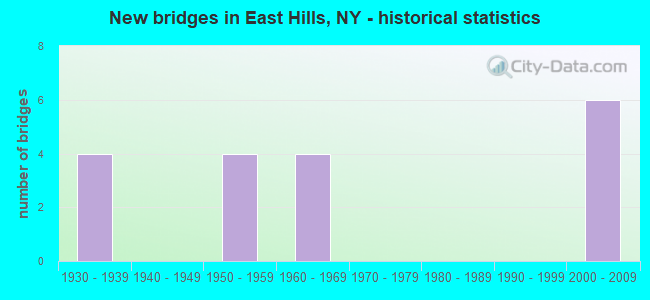
- New bridges - historical statistics
- 41930-1939
- 41950-1959
- 41960-1969
- 62000-2009
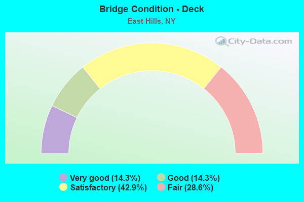
- Bridge Condition - Deck
- 14.3%Very good
- 14.3%Good
- 42.9%Satisfactory
- 28.6%Fair
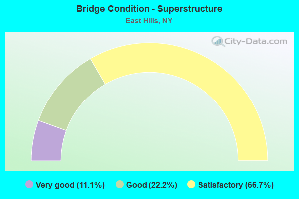
- Bridge Condition - Superstructure
- 11.1%Very good
- 22.2%Good
- 66.7%Satisfactory
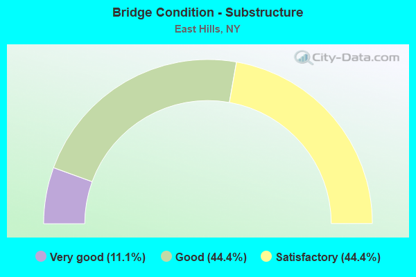
- Bridge Condition - Substructure
- 11.1%Very good
- 44.4%Good
- 44.4%Satisfactory
Find on map >> Show street view
Structure Number: 1049069, Location: I495 -4.6 MI NE QNS CO LN (Lat: 40.784722, Lng: -73.638847), Route carried "on" structure: Interstate 495, Year Built: 2000, Status: Open, Structure Length: 3.38m (11.09ft), Average Daily Traffic: 175,260 (year 2018), Truck Traffic: 10%, Average Future Daily Traffic: 184,023 (year 2040), Design Load: HS 25 or greater, Features Intersected: ROSLYN ROAD
Minimum Vertical Clearance: 30+ m (98+ ft), Kilometerpoint: 7.739, Lanes on structure: 8, Lanes under structure: 6, Base Highway Network: Yes, Owner: State Highway Agency, Approaching Roadway Width: 39.3m (128.9ft), Skew: 21 degrees, Material/Design: Prestressed concrete, Design/Construction: Box Beam or Girders - Multiple, Number Of Spans In Main Unit: 1, Length of Maximum Span: 32.8m (107.6ft), Curb-To-Curb Width: 39.3m (128.9ft), Out-to-Out Width: 41.7m (136.8ft)
Condition: Deck: Satisfactory, Superstructure: Good, Substructure: Good, Operating Rating: 39.5 metric tons, Method Used To Determine Operating Rating: Load and Resistance Factor Rating (LRFR) rating reported by rating factor(RF) method using HL-93 loadings, Inventory Rating: 30.5 metric tons, Method Used To Determine Inventory Rating: Load and Resistance Factor Rating (LRFR) rating reported by rating factor(RF) method using HL-93 loadings, Structural Evaluation: Better than present minimum criteria, Deck Geometry: Superior to present desirable criteria, Underclear: Somewhat better than minimum adequacy, Approach Roadway Alignment: Equal to present desirable criteria, Length Of Structure Improvement: 3.38m (11.09ft), Designated Inspection Frequency: Every 24 months, Inspection Date: June 2020, Bridge Improvement Cost: $6,760,000, Roadway Improvement Cost: $3,958,000, Total Project Cost: $10,718,000 ( Estimate for 2021), Deck Structure Type: Concrete Cast-file-Place, Wearing Surface/Protective System: Wearing Surface: Monolithic Concrete, Deck Protection: Epoxy Coated Reinforcing
Find on map >> Show street view
Structure Number: 1049079, Location: I495 - 7.75KM NE QNS CLL (Lat: 40.784364, Lng: -73.634358), Route carried "on" structure: Interstate 495, Year Built: 2003, Status: Open, Structure Length: 2.59m (8.50ft), Average Daily Traffic: 175,260 (year 2018), Truck Traffic: 10%, Average Future Daily Traffic: 184,023 (year 2040), Design Load: HS 25 or greater, Features Intersected: LOCUST LANE
Minimum Vertical Clearance: 30+ m (98+ ft), Kilometerpoint: 8.109, Lanes on structure: 8, Lanes under structure: 2, Base Highway Network: Yes, Owner: State Highway Agency, Approaching Roadway Width: 39.3m (128.9ft), Skew: 20 degrees, Material/Design: Steel, Design/Construction: Stringer/Multi-beam, Number Of Spans In Main Unit: 1, Length of Maximum Span: 24.5m (80.4ft), Curb-To-Curb Width: 39.2m (128.6ft), Out-to-Out Width: 41.8m (137.1ft)
Condition: Deck: Very good, Superstructure: Very good, Substructure: Very good, Operating Rating: 64.5 metric tons, Method Used To Determine Operating Rating: Load and Resistance Factor Rating (LRFR) rating reported by rating factor(RF) method using HL-93 loadings, Inventory Rating: 49.6 metric tons, Method Used To Determine Inventory Rating: Load and Resistance Factor Rating (LRFR) rating reported by rating factor(RF) method using HL-93 loadings, Structural Evaluation: Equal to present desirable criteria, Deck Geometry: Superior to present desirable criteria, Underclear: Somewhat better than minimum adequacy, Approach Roadway Alignment: Equal to present minimum criteria, Length Of Structure Improvement: 2.59m (8.50ft), Designated Inspection Frequency: Every 24 months, Inspection Date: June 2020, Bridge Improvement Cost: $7,519,000, Roadway Improvement Cost: $4,403,000, Total Project Cost: $11,922,000 ( Estimate for 2021), Deck Structure Type: Concrete Cast-file-Place, Wearing Surface/Protective System: Wearing Surface: Integral Concrete, Deck Protection: Epoxy Coated Reinforcing
Find on map >> Show street view
Structure Number: 104908, Location: I495 - 5.2 MI NE QUEENS C (Lat: 40.783964, Lng: -73.626492), Route carried "on" structure: Ramp Other road , Year Built: 2000, Status: Open, Structure Length: 8.53m (27.99ft), Truck Traffic: 10%, Design Load: HS 25 or greater, Features Intersected: 495I495I03021055, RTE I4, Facility Carried by Structure: NSP WB TO 495I WB
Minimum Vertical Clearance: 30+ m (98+ ft), Kilometerpoint: 0.821, Lanes on structure: 2, Lanes under structure: 10, Owner: State Highway Agency, Approaching Roadway Width: 11.3m (37.1ft), Skew: 2 degrees, Material/Design: Steel continuous, Design/Construction: Stringer/Multi-beam, Number Of Spans In Main Unit: 2, Length of Maximum Span: 42.3m (138.8ft), Curb-To-Curb Width: 11.2m (36.7ft), Out-to-Out Width: 12.3m (40.4ft)
Condition: Deck: Good, Superstructure: Good, Substructure: Good, Inventory Rating: 45.4 metric tons, Method Used To Determine Inventory Rating: Load Factor (LF), Structural Evaluation: Better than present minimum criteria, Deck Geometry: Superior to present desirable criteria, Underclear: High priority of corrective action, Approach Roadway Alignment: Equal to present desirable criteria, Length Of Structure Improvement: 8.53m (27.99ft), Designated Inspection Frequency: Every 24 months, Inspection Date: Febuary 2020, Bridge Improvement Cost: $4,415,000, Roadway Improvement Cost: $2,586,000, Total Project Cost: $7,001,000 ( Estimate for 2021), Deck Structure Type: Concrete Cast-file-Place, Wearing Surface/Protective System: Wearing Surface: Monolithic Concrete, Deck Protection: Epoxy Coated Reinforcing
Find on map >> Show street view
Structure Number: 105049, Location: RTE 495-5.2 MI NE QNS CL (Lat: 40.782981, Lng: -73.626125), Route carried "on" structure: Ramp Other road , Year Built: 1959, Status: Open, Structure Length: 4.42m (14.50ft), Truck Traffic: 10%, Design Load: HS 20+Mod, Features Intersected: RTE 906A, Facility Carried by Structure: NSP WB TO 495I WB
Minimum Vertical Clearance: 30+ m (98+ ft), Kilometerpoint: 0.740, Lanes on structure: 2, Lanes under structure: 3, Owner: State Highway Agency, Approaching Roadway Width: 11.3m (37.1ft), Skew: 3 degrees, Material/Design: Steel, Design/Construction: Stringer/Multi-beam, Number Of Spans In Main Unit: 3, Length of Maximum Span: 17.3m (56.8ft), Curb-To-Curb Width: 11.2m (36.7ft), Out-to-Out Width: 12.4m (40.7ft)
Condition: Deck: Satisfactory, Superstructure: Satisfactory, Substructure: Satisfactory, Operating Rating: 54.4 metric tons, Method Used To Determine Operating Rating: Load Factor (LF), Inventory Rating: 32.7 metric tons, Method Used To Determine Inventory Rating: Load Factor (LF), Structural Evaluation: Equal to present minimum criteria, Deck Geometry: Superior to present desirable criteria, Underclear: High priority of corrective action, Approach Roadway Alignment: Better than present minimum criteria, Length Of Structure Improvement: 4.41m (14.47ft), Designated Inspection Frequency: Every 24 months, Inspection Date: June 2021, Bridge Improvement Cost: $2,199,000, Roadway Improvement Cost: $1,288,000, Total Project Cost: $3,487,000 ( Estimate for 2021), Deck Structure Type: Concrete Cast-file-Place, Wearing Surface/Protective System: Wearing Surface: Bituminous, Membrane: Preformed Fabric
Find on map >> Show street view
Structure Number: 10505, Location: I495 - 5.2 MI NE QNS C L (Lat: 40.783169, Lng: -73.626703), Route carried "on" structure: Ramp Interstate , Year Built: 1959, Status: Open, Structure Length: 5.85m (19.19ft), Truck Traffic: 10%, Design Load: HS 20+Mod, Features Intersected: RTE 906A, Facility Carried by Structure: 495I EB TO NSP EB
Minimum Vertical Clearance: 30+ m (98+ ft), Kilometerpoint: 0.611, Lanes on structure: 2, Lanes under structure: 3, Owner: State Highway Agency, Approaching Roadway Width: 11.3m (37.1ft), Skew: 5 degrees, Material/Design: Steel, Design/Construction: Stringer/Multi-beam, Number Of Spans In Main Unit: 3, Length of Maximum Span: 22.5m (73.8ft), Curb-To-Curb Width: 11.3m (37.1ft), Out-to-Out Width: 12.4m (40.7ft)
Condition: Deck: Fair, Superstructure: Satisfactory, Substructure: Satisfactory, Operating Rating: 55.3 metric tons, Method Used To Determine Operating Rating: Load Factor (LF), Inventory Rating: 31.8 metric tons, Method Used To Determine Inventory Rating: Load Factor (LF), Structural Evaluation: Equal to present minimum criteria, Deck Geometry: Superior to present desirable criteria, Underclear: High priority of corrective action, Approach Roadway Alignment: Better than present minimum criteria, Length Of Structure Improvement: 5.85m (19.19ft), Designated Inspection Frequency: Every 24 months, Inspection Date: June 2021, Bridge Improvement Cost: $2,976,000, Roadway Improvement Cost: $1,743,000, Total Project Cost: $4,719,000 ( Estimate for 2021), Deck Structure Type: Concrete Cast-file-Place, Wearing Surface/Protective System: Wearing Surface: Bituminous, Membrane: Preformed Fabric
Find on map >> Show street view
Structure Number: 105706, Location: NSP - 4.2 MI NE QNS CO LN (Lat: 40.781058, Lng: -73.639339), Route carried "on" structure: County highway , Year Built: 1968, Status: Open, Structure Length: 2.37m (7.78ft), Average Daily Traffic: 8,633 (year 2020), Truck Traffic: 4%, Average Future Daily Traffic: 10,487 (year 2040), Design Load: HS 20, Features Intersected: RTE 908G, Facility Carried by Structure: ROSLYN ROAD
Minimum Vertical Clearance: 30+ m (98+ ft), Kilometerpoint: 8.608, Lanes on structure: 5, Lanes under structure: 3, Owner: State Highway Agency, Approaching Roadway Width: 15.8m (51.8ft), Skew: 1 degrees, Material/Design: Concrete, Design/Construction: Arch - Deck, Number Of Spans In Main Unit: 1, Length of Maximum Span: 21.9m (71.9ft), Curb or Sidewalk Widths: Left: 2.1m (6.9ft), Right: 2.1m (6.9ft), Curb-To-Curb Width: 15.8m (51.8ft), Out-to-Out Width: 21.3m (69.9ft)
Condition: Superstructure: Satisfactory, Substructure: Satisfactory, Operating Rating: 86.6 metric tons, Method Used To Determine Operating Rating: Field evaluation and documented engineering judgment, Inventory Rating: 29.4 metric tons, Method Used To Determine Inventory Rating: Field evaluation and documented engineering judgment, Structural Evaluation: Equal to present minimum criteria, Deck Geometry: High priority of replacement, Underclear: High priority of corrective action, Approach Roadway Alignment: Equal to present desirable criteria, Length Of Structure Improvement: 2.37m (7.78ft), Designated Inspection Frequency: Every 24 months, Inspection Date: January 2020, Bridge Improvement Cost: $4,051,000, Roadway Improvement Cost: $2,372,000, Total Project Cost: $6,423,000 ( Estimate for 2021)
Find on map >> Show street view
Structure Number: 10575, Location: NSP - 5.1 MI NE QUEENS C (Lat: 40.780056, Lng: -73.626753), Route carried "on" structure: State highway 908G, Year Built: 1968, Status: Open, Structure Length: 1.49m (4.89ft), Average Daily Traffic: 121,166 (year 2017), Average Future Daily Traffic: 144,126 (year 2040), Features Intersected: RTE I495
Minimum Vertical Clearance: 30+ m (98+ ft), Kilometerpoint: 8.061, Lanes on structure: 3, Lanes under structure: 1, Base Highway Network: Yes, Owner: State Highway Agency, Approaching Roadway Width: 11.3m (37.1ft), Skew: 3 degrees, Material/Design: Concrete, Design/Construction: Frame, Number Of Spans In Main Unit: 1, Length of Maximum Span: 13.7m (44.9ft), Curb or Sidewalk Widths: Left: 4.9m (16.1ft), Right: 0.0m, Curb-To-Curb Width: 11.3m (37.1ft), Out-to-Out Width: 18.9m (62.0ft)
Condition: Deck: Fair, Superstructure: Satisfactory, Substructure: Satisfactory, Operating Rating: 78.4 metric tons, Method Used To Determine Operating Rating: Field evaluation and documented engineering judgment, Inventory Rating: 19.6 metric tons, Method Used To Determine Inventory Rating: Field evaluation and documented engineering judgment, Structural Evaluation: Meets minimum limits, Deck Geometry: High priority of replacement, Underclear: Meets minimum limits, Approach Roadway Alignment: Equal to present desirable criteria, Length Of Structure Improvement: 1.49m (4.89ft), Designated Inspection Frequency: Every 24 months, Inspection Date: January 2020, Bridge Improvement Cost: $2,432,000, Roadway Improvement Cost: $1,424,000, Total Project Cost: $3,856,000 ( Estimate for 2021), Wearing Surface/Protective System: Wearing Surface: Bituminous, Membrane: Preformed Fabric
Find on map >> Show street view
Structure Number: 105806, Location: NSP - 4.2 MI NE QNS CO LN (Lat: 40.780858, Lng: -73.639306), Route carried "on" structure: County highway , Year Built: 1934, Status: Open, Structure Length: 2.01m (6.59ft), Average Daily Traffic: 12,105 (year 2017), Truck Traffic: 4%, Average Future Daily Traffic: 14,705 (year 2039), Features Intersected: RTE 908G, Facility Carried by Structure: ROSLYN ROAD
Minimum Vertical Clearance: 30+ m (98+ ft), Kilometerpoint: 8.592, Lanes on structure: 4, Lanes under structure: 3, Owner: State Highway Agency, Approaching Roadway Width: 15.8m (51.8ft), Skew: 1 degrees, Material/Design: Concrete, Design/Construction: Arch - Deck, Number Of Spans In Main Unit: 1, Length of Maximum Span: 18.2m (59.7ft), Curb or Sidewalk Widths: Left: 2.1m (6.9ft), Right: 2.1m (6.9ft), Curb-To-Curb Width: 15.8m (51.8ft), Out-to-Out Width: 21.3m (69.9ft)
Condition: Superstructure: Satisfactory, Substructure: Good, Operating Rating: 55.9 metric tons, Method Used To Determine Operating Rating: Field evaluation and documented engineering judgment, Inventory Rating: 20.3 metric tons, Method Used To Determine Inventory Rating: Field evaluation and documented engineering judgment, Structural Evaluation: Somewhat better than minimum adequacy, Deck Geometry: Meets minimum limits, Underclear: High priority of corrective action, Approach Roadway Alignment: Equal to present desirable criteria, Length Of Structure Improvement: 2.01m (6.59ft), Designated Inspection Frequency: Every 24 months, Inspection Date: May 2020, Bridge Improvement Cost: $3,074,000, Roadway Improvement Cost: $1,800,000, Total Project Cost: $4,873,000 ( Estimate for 2021), Wearing Surface/Protective System: Wearing Surface: Bituminous, Membrane: Preformed Fabric
Find on map >> Show street view
Structure Number: 1058079, Location: NSP - 4.8 MI NE QNS CO LN (Lat: 40.780464, Lng: -73.632614), Route carried "on" structure: State highway 908G, Year Built: 1934, Year Reconstructed: 1968, Status: Open, Structure Length: 1.80m (5.91ft), Average Daily Traffic: 121,166 (year 2017), Average Future Daily Traffic: 144,126 (year 2040), Features Intersected: LOCUST LANE
Minimum Vertical Clearance: 30+ m (98+ ft), Kilometerpoint: 7.578, Lanes on structure: 6, Lanes under structure: 2, Base Highway Network: Yes, Owner: State Highway Agency, Approaching Roadway Width: 25.6m (84.0ft), Skew: 21 degrees, Material/Design: Concrete, Design/Construction: Frame, Number Of Spans In Main Unit: 1, Length of Maximum Span: 15.5m (50.9ft), Curb or Sidewalk Widths: Left: 4.7m (15.4ft), Right: 4.7m (15.4ft), Curb-To-Curb Width: 25.5m (83.7ft), Out-to-Out Width: 36.9m (121.1ft)
Condition: Deck: Satisfactory, Superstructure: Satisfactory, Substructure: Good, Operating Rating: 55.9 metric tons, Method Used To Determine Operating Rating: Field evaluation and documented engineering judgment, Inventory Rating: 20.7 metric tons, Method Used To Determine Inventory Rating: Field evaluation and documented engineering judgment, Structural Evaluation: Somewhat better than minimum adequacy, Deck Geometry: Meets minimum limits, Underclear: High priority of corrective action, Approach Roadway Alignment: Equal to present desirable criteria, Length Of Structure Improvement: 1.79m (5.87ft), Designated Inspection Frequency: Every 24 months, Inspection Date: January 2020, Bridge Improvement Cost: $3,715,000, Roadway Improvement Cost: $2,176,000, Total Project Cost: $5,891,000 ( Estimate for 2021), Wearing Surface/Protective System: Wearing Surface: Bituminous, Membrane: Preformed Fabric
Find on map >> Show street view
Structure Number: 1049069, Location: I495 -4.6 MI NE QNS CO LN (Lat: 40.784722, Lng: -73.638847), Route carried "under" structure: County highway , Year Built: 2000, Structure Length: 0. m, Average Daily Traffic: 18,309 (year 2002), Features Intersected: ROSLYN ROAD, Facility Carried by Structure: RTE I495
Minimum Vertical Clearance: 4.95m (16.24ft), Kilometerpoint: 0.000, Lanes on structure: 8, Lanes under structure: 6, Material/Design: Prestressed concrete, Design/Construction: Box Beam or Girders - Multiple, Length of Maximum Span: 32.8m (107.6ft)
Find on map >> Show street view
Structure Number: 1049079, Location: I495 - 7.75KM NE QNS CLL (Lat: 40.784364, Lng: -73.634358), Route carried "under" structure: Other road , Year Built: 2003, Structure Length: 0. m, Features Intersected: LOCUST LANE, Facility Carried by Structure: RTE I495
Minimum Vertical Clearance: 4.55m (14.93ft), Kilometerpoint: 0.000, Lanes on structure: 8, Lanes under structure: 2, Material/Design: Steel, Design/Construction: Stringer/Multi-beam, Length of Maximum Span: 24.5m (80.4ft)
Find on map >> Show street view
Structure Number: 104908, Location: I495 - 5.2 MI NE QUEENS C (Lat: 40.783964, Lng: -73.626492), Route carried "under" structure: Interstate 495, Year Built: 2000, Structure Length: 0. m, Average Daily Traffic: 222,948 (year 2002), Features Intersected: 495I495I03021055, RTE I4
Minimum Vertical Clearance: 5.03m (16.50ft), Kilometerpoint: 8.817, Lanes on structure: 2, Lanes under structure: 5, Material/Design: Steel continuous, Design/Construction: Stringer/Multi-beam, Length of Maximum Span: 42.3m (138.8ft)
Find on map >> Show street view
Structure Number: 105049, Location: RTE 495-5.2 MI NE QNS CL (Lat: 40.782981, Lng: -73.626125), Route carried "under" structure: ServiceInterstate 906A, Year Built: 1959, Structure Length: 0. m, Average Daily Traffic: 11,500 (year 1978), Features Intersected: RTE 906A, Facility Carried by Structure: NSP WB TO 495I WB
Minimum Vertical Clearance: 4.42m (14.50ft), Kilometerpoint: 8.544, Lanes on structure: 2, Lanes under structure: 3, Material/Design: Steel, Design/Construction: Stringer/Multi-beam, Length of Maximum Span: 17.3m (56.8ft)
Find on map >> Show street view
Structure Number: 10505, Location: I495 - 5.2 MI NE QNS C L (Lat: 40.783169, Lng: -73.626703), Route carried "under" structure: ServiceInterstate 906A, Year Built: 1959, Structure Length: 0. m, Average Daily Traffic: 11,500 (year 1978), Features Intersected: RTE 906A, Facility Carried by Structure: 495I EB TO NSP EB
Minimum Vertical Clearance: 4.52m (14.83ft), Kilometerpoint: 8.640, Lanes on structure: 2, Lanes under structure: 3, Material/Design: Steel, Design/Construction: Stringer/Multi-beam, Length of Maximum Span: 22.5m (73.8ft)
Find on map >> Show street view
Structure Number: 105706, Location: NSP - 4.2 MI NE QNS CO LN (Lat: 40.781058, Lng: -73.639339), Route carried "under" structure: State highway 908G, Year Built: 1968, Structure Length: 0. m, Average Daily Traffic: 140,921 (year 2002), Features Intersected: RTE 908G, Facility Carried by Structure: ROSLYN ROAD
Minimum Vertical Clearance: 4.57m (14.99ft), Kilometerpoint: 7.047, Lanes on structure: 5, Lanes under structure: 3, Material/Design: Concrete, Design/Construction: Arch - Deck, Length of Maximum Span: 21.9m (71.9ft)
Find on map >> Show street view
Structure Number: 10575, Location: NSP - 5.1 MI NE QUEENS C (Lat: 40.780056, Lng: -73.626753), Route carried "under" structure: Ramp Other road 495, Year Built: 1968, Structure Length: 0. m, Average Daily Traffic: 25,910 (year 1975), Features Intersected: RTE I495, Facility Carried by Structure: RTE 908G
Minimum Vertical Clearance: 4.72m (15.49ft), Kilometerpoint: 0.000, Lanes on structure: 3, Lanes under structure: 1, Material/Design: Concrete, Design/Construction: Frame, Length of Maximum Span: 13.7m (44.9ft)
Find on map >> Show street view
Structure Number: 105806, Location: NSP - 4.2 MI NE QNS CO LN (Lat: 40.780858, Lng: -73.639306), Route carried "under" structure: State highway 908G, Year Built: 1934, Structure Length: 0. m, Average Daily Traffic: 140,921 (year 2002), Features Intersected: RTE 908G, Facility Carried by Structure: ROSLYN ROAD
Minimum Vertical Clearance: 4.37m (14.34ft), Kilometerpoint: 7.047, Lanes on structure: 4, Lanes under structure: 3, Material/Design: Concrete, Design/Construction: Arch - Deck, Length of Maximum Span: 18.2m (59.7ft)
Find on map >> Show street view
Structure Number: 1058079, Location: NSP - 4.8 MI NE QNS CO LN (Lat: 40.780464, Lng: -73.632614), Route carried "under" structure: County highway , Year Built: 1934, Structure Length: 0. m, Average Daily Traffic: 100 (year 2021), Features Intersected: LOCUST LANE, Facility Carried by Structure: RTE 908G
Minimum Vertical Clearance: 4.32m (14.17ft), Kilometerpoint: 0.000, Lanes on structure: 6, Lanes under structure: 2, Material/Design: Concrete, Design/Construction: Frame, Length of Maximum Span: 15.5m (50.9ft)