Bridge Statistics for Early, Texas (TX)
Condition, Traffic, Stress, Structural Evaluation, Project Costs
- National Bridge Inventory (NBI) Statistics
- 14Number of bridges
- 85ft / 26.4mTotal length
- $38,000Total costs
- 62,871Total average daily traffic
- 5,881Total average daily truck traffic
- 86,746Total future (year 2033) average daily traffic
- National Bridge Inventory (NBI) Registered Bridges for Early
- No street view available for this location
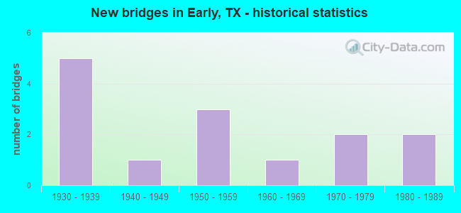
- New bridges - historical statistics
- 51930-1939
- 11940-1949
- 31950-1959
- 11960-1969
- 21970-1979
- 21980-1989

- Reconstructed bridges - Historical Statistics
- 21970-1979
- 41980-1989
- 11990-1999
- 12000-2009


- Bridge Condition - Deck
- 60.0%Good
- 40.0%Satisfactory

- Bridge Condition - Superstructure
- 60.0%Good
- 40.0%Satisfactory

- Bridge Condition - Substructure
- 40.0%Good
- 60.0%Satisfactory

- Bridge Condition - Channel
- 7.1%Very good
- 21.4%Good
- 57.1%Satisfactory
- 14.3%Fair

- Bridge Condition - Culverts
- 33.3%Good
- 55.6%Satisfactory
- 11.1%Fair
Find on map >> Show street view
Structure Number: 230250005407032, Location: 1.25 MI SE OF US 67 (Lat: 31.733458, Lng: -98.926567), Route carried "on" structure: US 84, Year Built: 1931, Year Reconstructed: 2013, Status: Open, Structure Length: 1.01m (3.31ft), Average Daily Traffic: 7,139 (year 2020), Truck Traffic: 14%, Average Future Daily Traffic: 10,690 (year 2038), Design Load: H 15, Features Intersected: DELAWARE CREEK
Minimum Vertical Clearance: 30+ m (98+ ft), Kilometerpoint: 34.398, Lanes on structure: 5, Base Highway Network: Yes, Owner: State Highway Agency, Approaching Roadway Width: 21.3m (69.9ft), Material/Design: Concrete, Design/Construction: Culvert, Number Of Spans In Main Unit: 3, Length of Maximum Span: 3.0m (9.8ft), Curb-To-Curb Width: 21.5m (70.5ft), Out-to-Out Width: 24.0m (78.7ft)
Condition: Channel: Fair, Culverts: Good, Operating Rating: 39.9 metric tons, Method Used To Determine Operating Rating: Load Factor (LF), Inventory Rating: 23.6 metric tons, Method Used To Determine Inventory Rating: Load Factor (LF), Structural Evaluation: Somewhat better than minimum adequacy, Deck Geometry: Somewhat better than minimum adequacy, Waterway Adequacy: Equal to present minimum criteria, Approach Roadway Alignment: Equal to present desirable criteria, Designated Inspection Frequency: Every 24 months, Inspection Date: March 2020, Deck Structure Type: Concrete Cast-file-Place, Wearing Surface/Protective System: Wearing Surface: Bituminous
Find on map >> Show street view
Structure Number: 230250005407074, Location: 3.85 MI SE OF US 67 (Lat: 31.718711, Lng: -98.886872), Route carried "on" structure: US 84, Year Built: 1963, Year Reconstructed: 1982, Status: Open, Structure Length: 3.66m (12.01ft), Average Daily Traffic: 4,409 (year 2020), Truck Traffic: 16%, Average Future Daily Traffic: 8,366 (year 2038), Design Load: H 20, Features Intersected: STEPPES CREEK
Minimum Vertical Clearance: 30+ m (98+ ft), Kilometerpoint: 38.512, Lanes on structure: 4, Base Highway Network: Yes, Owner: State Highway Agency, Approaching Roadway Width: 16.5m (54.1ft), Material/Design: Concrete, Design/Construction: Stringer/Multi-beam, Number Of Spans In Main Unit: 3, Length of Maximum Span: 12.2m (40.0ft), Curb-To-Curb Width: 17.3m (56.8ft), Out-to-Out Width: 18.0m (59.1ft)
Condition: Deck: Good, Superstructure: Good, Substructure: Good, Channel: Good, Operating Rating: 53.5 metric tons, Method Used To Determine Operating Rating: Load Factor (LF), Inventory Rating: 32.7 metric tons, Method Used To Determine Inventory Rating: Load Factor (LF), Structural Evaluation: Better than present minimum criteria, Deck Geometry: Somewhat better than minimum adequacy, Waterway Adequacy: Equal to present minimum criteria, Approach Roadway Alignment: Equal to present desirable criteria, Designated Inspection Frequency: Every 24 months, Inspection Date: March 2020, Deck Structure Type: Concrete Cast-file-Place, Wearing Surface/Protective System: Wearing Surface: Bituminous
Find on map >> Show street view
Structure Number: 230250007901002, Location: 1.75 MI NE OF US 84 (Lat: 31.752617, Lng: -98.918347), Route carried "on" structure: US 67, Year Built: 1930, Year Reconstructed: 1991, Status: Open, Structure Length: 0.85m (2.79ft), Average Daily Traffic: 13,869 (year 2020), Truck Traffic: 9%, Average Future Daily Traffic: 20,583 (year 2038), Design Load: H 15, Features Intersected: DELAWARE CREEK RELIEF
Minimum Vertical Clearance: 30+ m (98+ ft), Kilometerpoint: 17.970, Lanes on structure: 5, Base Highway Network: Yes, Owner: State Highway Agency, Approaching Roadway Width: 25.0m (82.0ft), Material/Design: Concrete, Design/Construction: Culvert, Number Of Spans In Main Unit: 5, Length of Maximum Span: 1.5m (4.9ft), Curb-To-Curb Width: 25.2m (82.7ft), Out-to-Out Width: 28.1m (92.2ft)
Condition: Channel: Very good, Culverts: Good, Operating Rating: 39.9 metric tons, Method Used To Determine Operating Rating: Load Factor (LF), Inventory Rating: 23.6 metric tons, Method Used To Determine Inventory Rating: Load Factor (LF), Structural Evaluation: Somewhat better than minimum adequacy, Deck Geometry: Superior to present desirable criteria, Waterway Adequacy: Equal to present minimum criteria, Approach Roadway Alignment: Equal to present desirable criteria, Designated Inspection Frequency: Every 24 months, Inspection Date: March 2020, Deck Structure Type: Concrete Cast-file-Place, Wearing Surface/Protective System: Wearing Surface: Bituminous
Find on map >> Show street view
Structure Number: 230250007901004, Location: 4.05 MI SW OF FM 1467 W (Lat: 31.780881, Lng: -98.854875), Route carried "on" structure: US 67, Year Built: 1930, Year Reconstructed: 1970, Status: Open, Structure Length: 0.76m (2.49ft), Average Daily Traffic: 4,901 (year 2020), Truck Traffic: 13%, Average Future Daily Traffic: 8,191 (year 2038), Design Load: H 15, Features Intersected: STEPPES CREEK
Minimum Vertical Clearance: 30+ m (98+ ft), Kilometerpoint: 11.220, Lanes on structure: 4, Base Highway Network: Yes, Owner: State Highway Agency, Approaching Roadway Width: 23.2m (76.1ft), Skew: 29 degrees, Material/Design: Concrete, Design/Construction: Culvert, Number Of Spans In Main Unit: 2, Length of Maximum Span: 3.0m (9.8ft), Curb-To-Curb Width: 23.2m (76.1ft), Out-to-Out Width: 42.9m (140.7ft)
Condition: Channel: Satisfactory, Culverts: Satisfactory, Operating Rating: 39.9 metric tons, Method Used To Determine Operating Rating: Load Factor (LF), Inventory Rating: 23.6 metric tons, Method Used To Determine Inventory Rating: Load Factor (LF), Structural Evaluation: Equal to present minimum criteria, Deck Geometry: Superior to present desirable criteria, Waterway Adequacy: Equal to present minimum criteria, Approach Roadway Alignment: Equal to present desirable criteria, Designated Inspection Frequency: Every 24 months, Inspection Date: March 2020
Find on map >> Show street view
Structure Number: 230250007901029, Location: 1.65 MI NE OF US 84 (Lat: 31.752125, Lng: -98.919744), Route carried "on" structure: US 67, Year Built: 1957, Year Reconstructed: 1991, Status: Open, Structure Length: 0.94m (3.08ft), Average Daily Traffic: 13,869 (year 2020), Truck Traffic: 9%, Average Future Daily Traffic: 20,583 (year 2038), Features Intersected: DELAWARE CRK
Minimum Vertical Clearance: 30+ m (98+ ft), Kilometerpoint: 18.108, Lanes on structure: 5, Base Highway Network: Yes, Owner: State Highway Agency, Approaching Roadway Width: 23.8m (78.1ft), Skew: 1 degrees, Material/Design: Concrete, Design/Construction: Culvert, Number Of Spans In Main Unit: 3, Length of Maximum Span: 2.7m (8.9ft), Curb-To-Curb Width: 26.2m (86.0ft), Out-to-Out Width: 27.5m (90.2ft)
Condition: Channel: Satisfactory, Culverts: Satisfactory, Operating Rating: 39.9 metric tons, Method Used To Determine Operating Rating: Load Factor (LF), Inventory Rating: 23.6 metric tons, Method Used To Determine Inventory Rating: Load Factor (LF), Structural Evaluation: Somewhat better than minimum adequacy, Deck Geometry: Superior to present desirable criteria, Waterway Adequacy: Equal to present minimum criteria, Approach Roadway Alignment: Equal to present desirable criteria, Designated Inspection Frequency: Every 24 months, Inspection Date: March 2020, Deck Structure Type: Concrete Cast-file-Place, Wearing Surface/Protective System: Wearing Surface: Bituminous
Find on map >> Show street view
Structure Number: 23025000790103, Location: 5.5 MI SW OF FM 1467 W (Lat: 31.771867, Lng: -98.874822), Route carried "on" structure: US 67, Year Built: 1957, Year Reconstructed: 1991, Status: Open, Structure Length: 0.67m (2.20ft), Average Daily Traffic: 5,310 (year 2020), Truck Traffic: 12%, Average Future Daily Traffic: 8,544 (year 2038), Features Intersected: DRAW
Minimum Vertical Clearance: 30+ m (98+ ft), Kilometerpoint: 13.464, Lanes on structure: 4, Base Highway Network: Yes, Owner: State Highway Agency, Approaching Roadway Width: 23.2m (76.1ft), Skew: 20 degrees, Material/Design: Concrete, Design/Construction: Culvert, Number Of Spans In Main Unit: 2, Length of Maximum Span: 3.0m (9.8ft), Curb-To-Curb Width: 23.2m (76.1ft), Out-to-Out Width: 30.2m (99.1ft)
Condition: Channel: Good, Culverts: Satisfactory, Operating Rating: 39.9 metric tons, Method Used To Determine Operating Rating: Load Factor (LF), Inventory Rating: 23.6 metric tons, Method Used To Determine Inventory Rating: Load Factor (LF), Structural Evaluation: Somewhat better than minimum adequacy, Deck Geometry: Superior to present desirable criteria, Waterway Adequacy: Equal to present minimum criteria, Approach Roadway Alignment: Equal to present desirable criteria, Designated Inspection Frequency: Every 24 months, Inspection Date: March 2020
Find on map >> Show street view
Structure Number: 230250243601003, Location: 2.85 MI SE OF US 67 (Lat: 31.712239, Lng: -98.935978), Route carried "on" structure: State highway 2525, Year Built: 1974, Year Reconstructed: 1988, Status: Open, Structure Length: 1.01m (3.31ft), Average Daily Traffic: 1,315 (year 2020), Truck Traffic: 20%, Average Future Daily Traffic: 1,966 (year 2038), Design Load: HS 20, Features Intersected: DELAWARE CREEK
Minimum Vertical Clearance: 30+ m (98+ ft), Kilometerpoint: 6.136, Lanes on structure: 2, Owner: State Highway Agency, Approaching Roadway Width: 9.1m (29.9ft), Material/Design: Concrete, Design/Construction: Culvert, Number Of Spans In Main Unit: 3, Length of Maximum Span: 3.0m (9.8ft), Curb-To-Curb Width: 10.4m (34.1ft), Out-to-Out Width: 15.2m (49.9ft)
Condition: Channel: Fair, Culverts: Satisfactory, Operating Rating: 39.9 metric tons, Method Used To Determine Operating Rating: Load Factor (LF), Inventory Rating: 23.6 metric tons, Method Used To Determine Inventory Rating: Load Factor (LF), Structural Evaluation: Equal to present minimum criteria, Deck Geometry: Equal to present minimum criteria, Waterway Adequacy: Better than present minimum criteria, Approach Roadway Alignment: Better than present minimum criteria, Designated Inspection Frequency: Every 24 months, Inspection Date: March 2020, Deck Structure Type: Concrete Cast-file-Place, Wearing Surface/Protective System: Wearing Surface: Bituminous
Find on map >> Show street view
Structure Number: 230250243601004, Location: 1.80 MI SE OF FM 2126 (Lat: 31.699356, Lng: -98.903608), Route carried "on" structure: State highway 2525, Year Built: 1977, Status: Open, Structure Length: 3.72m (12.20ft), Average Daily Traffic: 454 (year 2020), Truck Traffic: 17%, Average Future Daily Traffic: 598 (year 2038), Design Load: H 15, Features Intersected: STEPPES CREEK
Minimum Vertical Clearance: 30+ m (98+ ft), Kilometerpoint: 9.794, Lanes on structure: 2, Owner: State Highway Agency, Approaching Roadway Width: 6.7m (22.0ft), Skew: 1 degrees, Material/Design: Concrete, Design/Construction: Stringer/Multi-beam, Number Of Spans In Main Unit: 3, Length of Maximum Span: 12.5m (41.0ft), Curb-To-Curb Width: 7.9m (25.9ft), Out-to-Out Width: 8.6m (28.2ft)
Condition: Deck: Good, Superstructure: Good, Substructure: Good, Channel: Good, Operating Rating: 44.4 metric tons, Method Used To Determine Operating Rating: Load Factor (LF), Inventory Rating: 32.7 metric tons, Method Used To Determine Inventory Rating: Load Factor (LF), Structural Evaluation: Better than present minimum criteria, Deck Geometry: Somewhat better than minimum adequacy, Waterway Adequacy: Superior to present desirable criteria, Approach Roadway Alignment: Equal to present minimum criteria, Designated Inspection Frequency: Every 24 months, Inspection Date: March 2020, Deck Structure Type: Concrete Cast-file-Place, Wearing Surface/Protective System: Wearing Surface: Bituminous
Find on map >> Show street view
Structure Number: 230250318001001, Location: 0.75 MI N OF US 67 (Lat: 31.770369, Lng: -98.903353), Route carried "on" structure: State highway 3100, Year Built: 1930, Status: Open, Structure Length: 0.91m (2.99ft), Average Daily Traffic: 787 (year 2020), Truck Traffic: 7%, Average Future Daily Traffic: 975 (year 2038), Features Intersected: DRAW
Minimum Vertical Clearance: 30+ m (98+ ft), Kilometerpoint: 13.041, Lanes on structure: 2, Owner: State Highway Agency, Approaching Roadway Width: 6.7m (22.0ft), Skew: 4 degrees, Material/Design: Masonry, Design/Construction: Culvert, Number Of Spans In Main Unit: 2, Length of Maximum Span: 2.4m (7.9ft), Curb-To-Curb Width: 8.1m (26.6ft), Out-to-Out Width: 8.2m (26.9ft)
Condition: Channel: Satisfactory, Culverts: Fair, Operating Rating: 32.7 metric tons, Method Used To Determine Operating Rating: Field evaluation and documented engineering judgment, Inventory Rating: 24.5 metric tons, Method Used To Determine Inventory Rating: Field evaluation and documented engineering judgment, Structural Evaluation: Somewhat better than minimum adequacy, Deck Geometry: Somewhat better than minimum adequacy, Waterway Adequacy: Better than present minimum criteria, Approach Roadway Alignment: Better than present minimum criteria, Designated Inspection Frequency: Every 24 months, Inspection Date: March 2020, Deck Structure Type: Concrete Cast-file-Place, Wearing Surface/Protective System: Wearing Surface: Bituminous
Find on map >> Show street view
Structure Number: 230250AA0269001, Location: 0.55 MI S OF US 84 (Lat: 31.707525, Lng: -98.877628), Route carried "on" structure: County highway 269, Year Built: 1944, Status: Open, Structure Length: 0.73m (2.40ft), Average Daily Traffic: 50 (year 2013), Average Future Daily Traffic: 50 (year 2033), Features Intersected: DRAW
Minimum Vertical Clearance: 30+ m (98+ ft), Kilometerpoint: 0.966, Lanes on structure: 2, Owner: County Highway Agency, Approaching Roadway Width: 5.5m (18.0ft), Material/Design: Masonry, Design/Construction: Culvert, Number Of Spans In Main Unit: 3, Length of Maximum Span: 1.8m (5.9ft), Curb-To-Curb Width: 7.0m (23.0ft), Out-to-Out Width: 8.0m (26.2ft)
Condition: Channel: Satisfactory, Culverts: Satisfactory, Operating Rating: 32.7 metric tons, Method Used To Determine Operating Rating: Field evaluation and documented engineering judgment, Inventory Rating: 24.5 metric tons, Method Used To Determine Inventory Rating: Field evaluation and documented engineering judgment, Structural Evaluation: Equal to present minimum criteria, Deck Geometry: Somewhat better than minimum adequacy, Waterway Adequacy: Meets minimum limits, Approach Roadway Alignment: Somewhat better than minimum adequacy, Length Of Structure Improvement: 0.70m (2.30ft), Designated Inspection Frequency: Every 24 months, Inspection Date: March 2021, Total Project Cost: $11,000, Deck Structure Type: Concrete Cast-file-Place, Wearing Surface/Protective System: Wearing Surface: Bituminous
Find on map >> Show street view
Structure Number: 230250AA0292001, Location: 2.45 MI E OF US 67 (Lat: 31.754147, Lng: -98.871794), Route carried "on" structure: County highway 292, Year Built: 1936, Year Reconstructed: 2004, Status: Open, Structure Length: 0.73m (2.40ft), Average Daily Traffic: 260 (year 2013), Truck Traffic: 2%, Average Future Daily Traffic: 200 (year 2033), Features Intersected: STEPPS CREEK
Minimum Vertical Clearance: 30+ m (98+ ft), Kilometerpoint: 3.701, Lanes on structure: 2, Owner: County Highway Agency, Approaching Roadway Width: 6.3m (20.7ft), Skew: 3 degrees, Material/Design: Concrete, Design/Construction: Slab, Number Of Spans In Main Unit: 1, Length of Maximum Span: 6.7m (22.0ft), Curb-To-Curb Width: 7.3m (24.0ft), Out-to-Out Width: 8.1m (26.6ft)
Condition: Deck: Satisfactory, Superstructure: Satisfactory, Substructure: Satisfactory, Channel: Satisfactory, Operating Rating: 32.7 metric tons, Method Used To Determine Operating Rating: Field evaluation and documented engineering judgment, Inventory Rating: 24.5 metric tons, Method Used To Determine Inventory Rating: Field evaluation and documented engineering judgment, Structural Evaluation: Equal to present minimum criteria, Deck Geometry: Somewhat better than minimum adequacy, Waterway Adequacy: Better than present minimum criteria, Approach Roadway Alignment: Equal to present desirable criteria, Length Of Structure Improvement: 0.73m (2.40ft), Designated Inspection Frequency: Every 24 months, Inspection Date: March 2021, Bridge Improvement Cost: $1,000, Total Project Cost: $1,000, Deck Structure Type: Concrete Cast-file-Place, Wearing Surface/Protective System: Wearing Surface: Bituminous
Find on map >> Show street view
Structure Number: 230250AA0598001, Location: 0.15 MI SW OF US 67 (Lat: 31.731953, Lng: -98.968622), Route carried "on" structure: County highway 598, Year Built: 1959, Status: Open, Structure Length: 3.66m (12.01ft), Average Daily Traffic: 100 (year 2013), Truck Traffic: 2%, Average Future Daily Traffic: 200 (year 2033), Features Intersected: PECAN BAYOU SLOUGH
Minimum Vertical Clearance: 30+ m (98+ ft), Kilometerpoint: 0.483, Lanes on structure: 2, Owner: County Highway Agency, Approaching Roadway Width: 5.5m (18.0ft), Material/Design: Concrete, Design/Construction: Stringer/Multi-beam, Number Of Spans In Main Unit: 4, Length of Maximum Span: 9.1m (29.9ft), Curb-To-Curb Width: 7.9m (25.9ft), Out-to-Out Width: 8.4m (27.6ft)
Condition: Deck: Good, Superstructure: Good, Substructure: Satisfactory, Channel: Satisfactory, Operating Rating: 53.5 metric tons, Method Used To Determine Operating Rating: Load Factor (LF), Inventory Rating: 32.7 metric tons, Method Used To Determine Inventory Rating: Load Factor (LF), Structural Evaluation: Equal to present minimum criteria, Deck Geometry: Equal to present minimum criteria, Waterway Adequacy: Better than present minimum criteria, Approach Roadway Alignment: Equal to present desirable criteria, Designated Inspection Frequency: Every 24 months, Inspection Date: December 2020, Deck Structure Type: Concrete Cast-file-Place, Wearing Surface/Protective System: Wearing Surface: Bituminous
Find on map >> Show street view
Structure Number: 230250B00655001, Location: 0.05 MI SW OF FM 2525 (Lat: 31.729492, Lng: -98.970106), Route carried "on" structure: County highway 807, Year Built: 1980, Status: Open, Structure Length: 6.71m (22.01ft), Average Daily Traffic: 10,148 (year 2017), Average Future Daily Traffic: 5,600 (year 2033), Design Load: HS 20, Features Intersected: PECAN BAYOU, Facility Carried by Structure: CC WOODSON
Minimum Vertical Clearance: 30+ m (98+ ft), Kilometerpoint: 2.747, Lanes on structure: 4, Owner: City or Municipal Highway Agency, Approaching Roadway Width: 14.0m (45.9ft), Material/Design: Prestressed concrete, Design/Construction: Box Beam or Girders - Multiple, Number Of Spans In Main Unit: 3, Length of Maximum Span: 24.4m (80.1ft), Curb-To-Curb Width: 14.8m (48.6ft), Out-to-Out Width: 15.3m (50.2ft)
Condition: Deck: Satisfactory, Superstructure: Satisfactory, Substructure: Satisfactory, Channel: Satisfactory, Operating Rating: 54.4 metric tons, Method Used To Determine Operating Rating: Assigned rating based on Load Factor Design (LFD) reported in metric tons, Inventory Rating: 32.7 metric tons, Method Used To Determine Inventory Rating: Assigned rating based on Load Factor Design (LFD) reported in metric tons, Structural Evaluation: Equal to present minimum criteria, Deck Geometry: High priority of replacement, Waterway Adequacy: Equal to present minimum criteria, Approach Roadway Alignment: Equal to present desirable criteria, Length Of Structure Improvement: 6.74m (22.11ft), Designated Inspection Frequency: Every 24 months, Inspection Date: December 2020, Bridge Improvement Cost: $21,000, Roadway Improvement Cost: $5,000, Total Project Cost: $26,000, Deck Structure Type: Concrete Precast Panels, Wearing Surface/Protective System: Wearing Surface: Bituminous
Find on map >> Show street view
Structure Number: 230250E00145001, Location: 0.20 MI W OF US 67 (Lat: 31.754594, Lng: -98.918286), Route carried "on" structure: City street , Year Built: 1982, Status: Open, Structure Length: 1.01m (3.31ft), Average Daily Traffic: 260 (year 2013), Truck Traffic: 2%, Average Future Daily Traffic: 200 (year 2033), Design Load: HS 20, Features Intersected: DELAWARE CREEK, Facility Carried by Structure: LONGHORN DR
Minimum Vertical Clearance: 30+ m (98+ ft), Kilometerpoint: 0.402, Lanes on structure: 2, Owner: City or Municipal Highway Agency, Approaching Roadway Width: 7.5m (24.6ft), Skew: 1 degrees, Material/Design: Concrete, Design/Construction: Culvert, Number Of Spans In Main Unit: 3, Length of Maximum Span: 3.0m (9.8ft), Curb-To-Curb Width: 10.4m (34.1ft), Out-to-Out Width: 10.8m (35.4ft)
Condition: Channel: Satisfactory, Culverts: Good, Operating Rating: 39.9 metric tons, Method Used To Determine Operating Rating: Load Factor (LF), Inventory Rating: 23.6 metric tons, Method Used To Determine Inventory Rating: Load Factor (LF), Structural Evaluation: Equal to present minimum criteria, Deck Geometry: Better than present minimum criteria, Waterway Adequacy: Better than present minimum criteria, Approach Roadway Alignment: Equal to present desirable criteria, Designated Inspection Frequency: Every 24 months, Inspection Date: March 2021, Deck Structure Type: Concrete Cast-file-Place, Wearing Surface/Protective System: Wearing Surface: Bituminous