Bridge Statistics for Dalton, Wisconsin (WI)
Condition, Traffic, Stress, Structural Evaluation, Project Costs
- National Bridge Inventory (NBI) Statistics
- 10Number of bridges
- 26ft / 7.7mTotal length
- 2,853Total average daily traffic
- 99Total average daily truck traffic
- National Bridge Inventory (NBI) Registered Bridges for Dalton
- No street view available for this location
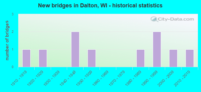
- New bridges - historical statistics
- 11910-1919
- 11920-1929
- 21940-1949
- 11950-1959
- 11980-1989
- 21990-1999
- 12000-2009
- 12010-2019

- Bridge Condition - Deck
- 16.7%Very good
- 33.3%Good
- 50.0%Satisfactory

- Bridge Condition - Superstructure
- 16.7%Very good
- 33.3%Good
- 50.0%Satisfactory

- Bridge Condition - Substructure
- 50.0%Very good
- 16.7%Good
- 16.7%Satisfactory
- 16.7%Fair

- Bridge Condition - Channel
- 37.5%Very good
- 50.0%Satisfactory
- 12.5%Fair

- Bridge Condition - Culverts
- 50.0%Good
- 50.0%Satisfactory
Find on map >> Show street view
Structure Number: B110111, Location: 1.0M E JCT STH 44 (Lat: 43.599681, Lng: -89.201747), Route carried "on" structure: City street , Year Built: 1993, Status: Open, Structure Length: 1.40m (4.59ft), Average Daily Traffic: 39 (year 2019), Truck Traffic: 10%, Average Future Daily Traffic: 42 (year 2039), Design Load: HS 20, Features Intersected: FOX RIVER, Facility Carried by Structure: LRD ROSS RD
Minimum Vertical Clearance: 30+ m (98+ ft), Kilometerpoint: 0.000, Lanes on structure: 2, Owner: Town or Township Highway Agency, Approaching Roadway Width: 7.3m (24.0ft), Skew: 2 degrees, Material/Design: Concrete, Design/Construction: Slab, Number Of Spans In Main Unit: 1, Length of Maximum Span: 13.4m (44.0ft), Curb-To-Curb Width: 7.3m (24.0ft), Out-to-Out Width: 7.9m (25.9ft)
Condition: Deck: Satisfactory, Superstructure: Satisfactory, Substructure: Good, Channel: Satisfactory, Operating Rating: 62.1 metric tons, Method Used To Determine Operating Rating: Load Factor (LF), Inventory Rating: 37.3 metric tons, Method Used To Determine Inventory Rating: Load Factor (LF), Structural Evaluation: Equal to present minimum criteria, Deck Geometry: Equal to present minimum criteria, Waterway Adequacy: Equal to present desirable criteria, Approach Roadway Alignment: Equal to present desirable criteria, Designated Inspection Frequency: Every 24 months, Inspection Date: July 2020, Deck Structure Type: Concrete Cast-file-Place, Wearing Surface/Protective System: Wearing Surface: Monolithic Concrete, Deck Protection: Epoxy Coated Reinforcing
Find on map >> Show street view
Structure Number: B240015, Location: 0.1M N JCT STH 44 (Lat: 43.652956, Lng: -89.206458), Route carried "on" structure: County highway , Year Built: 1985, Status: Open, Structure Length: 0.75m (2.46ft), Average Daily Traffic: 385 (year 2019), Average Future Daily Traffic: 423 (year 2040), Design Load: HS 20, Features Intersected: BELLE FOUNTAIN CREEK, Facility Carried by Structure: CTH FF
Minimum Vertical Clearance: 30+ m (98+ ft), Kilometerpoint: 0.000, Lanes on structure: 2, Owner: County Highway Agency, Approaching Roadway Width: 8.5m (27.9ft), Skew: 1 degrees, Material/Design: Concrete, Design/Construction: Culvert, Number Of Spans In Main Unit: 2, Length of Maximum Span: 3.4m (11.2ft)
Condition: Channel: Fair, Culverts: Good, Operating Rating: 53.9 metric tons, Method Used To Determine Operating Rating: Field evaluation and documented engineering judgment, Inventory Rating: 32.4 metric tons, Method Used To Determine Inventory Rating: Field evaluation and documented engineering judgment, Structural Evaluation: Better than present minimum criteria, Waterway Adequacy: Equal to present desirable criteria, Approach Roadway Alignment: Equal to present desirable criteria, Designated Inspection Frequency: Every 24 months, Inspection Date: September 2021, Deck Structure Type: Concrete Cast-file-Place, Wearing Surface/Protective System: Wearing Surface: Bituminous
Find on map >> Show street view
Structure Number: B240022, Location: 0.3M S JCT CTH B (Lat: 43.695631, Lng: -89.216817), Route carried "on" structure: City street , Year Built: 1994, Status: Open, Structure Length: 0.97m (3.18ft), Average Daily Traffic: 99 (year 2019), Truck Traffic: 8%, Average Future Daily Traffic: 108 (year 2039), Design Load: HS 20, Features Intersected: BELLE FOUNTAIN CREEK, Facility Carried by Structure: LRD LOVERS LANE
Minimum Vertical Clearance: 30+ m (98+ ft), Kilometerpoint: 0.000, Lanes on structure: 2, Owner: Town or Township Highway Agency, Approaching Roadway Width: 8.5m (27.9ft), Skew: 1 degrees, Material/Design: Concrete, Design/Construction: Slab, Number Of Spans In Main Unit: 1, Length of Maximum Span: 9.1m (29.9ft), Curb-To-Curb Width: 7.3m (24.0ft), Out-to-Out Width: 7.9m (25.9ft)
Condition: Deck: Good, Superstructure: Good, Substructure: Very good, Channel: Very good, Operating Rating: 67.0 metric tons, Method Used To Determine Operating Rating: Load Factor (LF), Inventory Rating: 40.5 metric tons, Method Used To Determine Inventory Rating: Load Factor (LF), Structural Evaluation: Better than present minimum criteria, Deck Geometry: Equal to present minimum criteria, Waterway Adequacy: Equal to present desirable criteria, Approach Roadway Alignment: Equal to present desirable criteria, Designated Inspection Frequency: Every 24 months, Inspection Date: May 2020, Deck Structure Type: Concrete Cast-file-Place, Wearing Surface/Protective System: Wearing Surface: Monolithic Concrete, Deck Protection: Epoxy Coated Reinforcing
Find on map >> Show street view
Structure Number: B240033, Location: 1.0M W JCT CTH FFF (Lat: 43.698942, Lng: -89.213053), Route carried "on" structure: County highway , Year Built: 2006, Status: Open, Structure Length: 1.08m (3.54ft), Average Daily Traffic: 595 (year 2019), Truck Traffic: 5%, Average Future Daily Traffic: 654 (year 2040), Design Load: HS 25 or greater, Features Intersected: BELLE FOUNTAIN CREEK, Facility Carried by Structure: CTH B
Minimum Vertical Clearance: 30+ m (98+ ft), Kilometerpoint: 0.000, Lanes on structure: 2, Owner: County Highway Agency, Approaching Roadway Width: 10.4m (34.1ft), Material/Design: Concrete continuous, Design/Construction: Slab, Number Of Spans In Main Unit: 1, Length of Maximum Span: 10.4m (34.1ft), Curb-To-Curb Width: 9.8m (32.2ft), Out-to-Out Width: 10.4m (34.1ft)
Condition: Deck: Good, Superstructure: Good, Substructure: Very good, Channel: Very good, Operating Rating: 71.8 metric tons, Method Used To Determine Operating Rating: Load Factor (LF), Inventory Rating: 42.1 metric tons, Method Used To Determine Inventory Rating: Load Factor (LF), Structural Evaluation: Better than present minimum criteria, Deck Geometry: Meets minimum limits, Waterway Adequacy: Equal to present desirable criteria, Approach Roadway Alignment: Equal to present desirable criteria, Designated Inspection Frequency: Every 48 months, Inspection Date: September 2021, Deck Structure Type: Concrete Cast-file-Place, Wearing Surface/Protective System: Wearing Surface: Monolithic Concrete, Deck Protection: Epoxy Coated Reinforcing
Find on map >> Show street view
Structure Number: B240042, Location: 2.8M W JCT CTH FFF (Lat: 43.687575, Lng: -89.243078), Route carried "on" structure: City street , Year Built: 2016, Status: Open, Structure Length: 1.17m (3.84ft), Average Daily Traffic: 100 (year 2019), Average Future Daily Traffic: 100 (year 2036), Design Load: HL 93, Features Intersected: BELLE FOUNTAIN CREEK, Facility Carried by Structure: LRD GILLETTE DR NB
Minimum Vertical Clearance: 30+ m (98+ ft), Kilometerpoint: 0.000, Lanes on structure: 2, Owner: Town or Township Highway Agency, Approaching Roadway Width: 6.1m (20.0ft), Material/Design: Concrete, Design/Construction: Slab, Number Of Spans In Main Unit: 1, Length of Maximum Span: 11.0m (36.1ft), Curb-To-Curb Width: 7.3m (24.0ft), Out-to-Out Width: 8.1m (26.6ft)
Condition: Deck: Very good, Superstructure: Very good, Substructure: Very good, Channel: Very good, Operating Rating: 44.7 metric tons, Method Used To Determine Operating Rating: Load and Resistance Factor Rating (LRFR) rating reported by rating factor(RF) method using HL-93 loadings, Inventory Rating: 34.3 metric tons, Method Used To Determine Inventory Rating: Load and Resistance Factor Rating (LRFR) rating reported by rating factor(RF) method using HL-93 loadings, Structural Evaluation: Equal to present desirable criteria, Deck Geometry: Equal to present minimum criteria, Waterway Adequacy: Equal to present desirable criteria, Approach Roadway Alignment: Meets minimum limits, Designated Inspection Frequency: Every 48 months, Inspection Date: May 2020, Deck Structure Type: Concrete Cast-file-Place, Wearing Surface/Protective System: Wearing Surface: Monolithic Concrete, Deck Protection: Epoxy Coated Reinforcing
Find on map >> Show street view
Structure Number: P110034, Location: 1.5M E JCT STH 44 (Lat: 43.614217, Lng: -89.187753), Route carried "on" structure: County highway , Year Built: 1955, Status: Open, Structure Length: 0.82m (2.69ft), Average Daily Traffic: 149 (year 2019), Average Future Daily Traffic: 163 (year 2039), Design Load: H 15, Features Intersected: FOX RIVER, Facility Carried by Structure: CTH E
Minimum Vertical Clearance: 30+ m (98+ ft), Kilometerpoint: 0.000, Lanes on structure: 2, Owner: County Highway Agency, Approaching Roadway Width: 7.9m (25.9ft), Material/Design: Wood or Timber, Design/Construction: Slab, Number Of Spans In Main Unit: 1, Length of Maximum Span: 7.9m (25.9ft), Curb-To-Curb Width: 8.0m (26.2ft), Out-to-Out Width: 8.4m (27.6ft)
Condition: Deck: Satisfactory, Superstructure: Satisfactory, Substructure: Fair, Channel: Satisfactory, Operating Rating: 47.4 metric tons, Method Used To Determine Operating Rating: Load Factor (LF), Inventory Rating: 32.4 metric tons, Method Used To Determine Inventory Rating: Load Factor (LF), Structural Evaluation: Somewhat better than minimum adequacy, Deck Geometry: Somewhat better than minimum adequacy, Waterway Adequacy: Equal to present desirable criteria, Approach Roadway Alignment: Equal to present desirable criteria, Designated Inspection Frequency: Every 24 months, Underwater Inspection Frequency: Every 60 months, Inspection Date: August 2020, Underwater Inspection Date: May 2019, Deck Structure Type: Wood or Timber, Wearing Surface/Protective System: Wearing Surface: Bituminous
Find on map >> Show street view
Structure Number: P110036, Location: 0.6M N JCT CTH E (Lat: 43.622492, Lng: -89.157400), Route carried "on" structure: County highway , Year Built: 1940, Status: Open, Structure Length: 0.82m (2.69ft), Average Daily Traffic: 177 (year 2019), Average Future Daily Traffic: 194 (year 2039), Design Load: H 15, Features Intersected: FOX RIVER, Facility Carried by Structure: CTH H
Minimum Vertical Clearance: 30+ m (98+ ft), Kilometerpoint: 0.000, Lanes on structure: 2, Owner: County Highway Agency, Approaching Roadway Width: 8.5m (27.9ft), Material/Design: Concrete continuous, Design/Construction: Culvert, Number Of Spans In Main Unit: 2, Length of Maximum Span: 3.7m (12.1ft)
Condition: Channel: Satisfactory, Culverts: Satisfactory, Operating Rating: 53.9 metric tons, Method Used To Determine Operating Rating: Field evaluation and documented engineering judgment, Inventory Rating: 24.3 metric tons, Method Used To Determine Inventory Rating: Field evaluation and documented engineering judgment, Structural Evaluation: Equal to present minimum criteria, Waterway Adequacy: Equal to present minimum criteria, Approach Roadway Alignment: Equal to present desirable criteria, Designated Inspection Frequency: Every 24 months, Inspection Date: August 2020, Deck Structure Type: Concrete Cast-file-Place, Wearing Surface/Protective System: Wearing Surface: Bituminous
Find on map >> Show street view
Structure Number: P110907, Location: 1.7M N JCT STH 33 (Lat: 43.596250, Lng: -89.187564), Route carried "on" structure: City street , Year Built: 1945, Status: Open, Structure Length: 0.73m (2.40ft), Average Daily Traffic: 33 (year 2019), Average Future Daily Traffic: 36 (year 2039), Design Load: HS 20, Features Intersected: SAND SPRING CREEK, Facility Carried by Structure: LRD LARSON RD
Minimum Vertical Clearance: 30+ m (98+ ft), Kilometerpoint: 0.000, Lanes on structure: 2, Owner: Town or Township Highway Agency, Approaching Roadway Width: 6.7m (22.0ft), Material/Design: Concrete, Design/Construction: Slab, Number Of Spans In Main Unit: 1, Length of Maximum Span: 6.7m (22.0ft), Curb-To-Curb Width: 8.2m (26.9ft), Out-to-Out Width: 8.8m (28.9ft)
Condition: Deck: Satisfactory, Superstructure: Satisfactory, Substructure: Satisfactory, Channel: Satisfactory, Operating Rating: 39.2 metric tons, Method Used To Determine Operating Rating: Load Factor (LF), Inventory Rating: 22.7 metric tons, Method Used To Determine Inventory Rating: Load Factor (LF), Structural Evaluation: Equal to present minimum criteria, Deck Geometry: Equal to present minimum criteria, Waterway Adequacy: Equal to present desirable criteria, Approach Roadway Alignment: Equal to present desirable criteria, Designated Inspection Frequency: Every 24 months, Inspection Date: August 2020, Deck Structure Type: Concrete Cast-file-Place, Wearing Surface/Protective System: Wearing Surface: Bituminous
Find on map >> Show street view
Structure Number: B240433, Location: 0.2M N JCT CTH FF (Lat: 43.654153, Lng: -89.204467), Route carried "under" structure: State highway 44, Year Built: 1922, Structure Length: 0. m, Average Daily Traffic: 1,201 (year 2019), Truck Traffic: 5%, Features Intersected: STH 44, Facility Carried by Structure: UNION PACIFIC RR
Minimum Vertical Clearance: 4.22m (13.85ft), Kilometerpoint: 0.000, Lanes under structure: 2, Material/Design: Steel, Design/Construction: Girder and Floorbeam System, Length of Maximum Span: 11.2m (36.7ft)
Find on map >> Show street view
Structure Number: P240037, Location: 1.0M S JCT STH 44 (Lat: 43.647389, Lng: -89.186822), Route carried "under" structure: County highway , Year Built: 1911, Structure Length: 0. m, Average Daily Traffic: 75 (year 2019), Features Intersected: CTH II, Facility Carried by Structure: CNW RR
Minimum Vertical Clearance: 3.79m (12.43ft), Kilometerpoint: 0.000, Lanes under structure: 2, Material/Design: Steel, Design/Construction: Girder and Floorbeam System, Length of Maximum Span: 8.6m (28.2ft)