Bridge Statistics for Crestview Hills, Kentucky (KY)
Condition, Traffic, Stress, Structural Evaluation, Project Costs
- National Bridge Inventory (NBI) Statistics
- 16Number of bridges
- 174ft / 53.2mTotal length
- 819,056Total average daily traffic
- 70,175Total average daily truck traffic
- National Bridge Inventory (NBI) Registered Bridges for Crestview Hills
- No street view available for this location
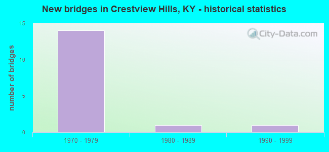
- New bridges - historical statistics
- 141970-1979
- 11980-1989
- 11990-1999


- Bridge Condition - Deck
- 62.5%Good
- 37.5%Satisfactory

- Bridge Condition - Superstructure
- 75.0%Good
- 25.0%Satisfactory

- Bridge Condition - Substructure
- 50.0%Good
- 50.0%Satisfactory
Find on map >> Show street view
Structure Number: 59B00051N, Location: .6 MI S OF JCT US 25-42 (Lat: 39.026389, Lng: -84.569444), Route carried "on" structure: State highway 1303, Year Built: 1974, Status: Open, Structure Length: 8.63m (28.31ft), Average Daily Traffic: 9,983 (year 2019), Truck Traffic: 4%, Average Future Daily Traffic: 9,284 (year 2039), Design Load: HS 20+Mod, Features Intersected: I 275, Facility Carried by Structure: TURKEYFOOT ROAD
Minimum Vertical Clearance: 30+ m (98+ ft), Kilometerpoint: 9.199, Lanes on structure: 4, Lanes under structure: 13, Owner: State Highway Agency, Approaching Roadway Width: 3.7m (12.1ft), Skew: 13 degrees, Material/Design: Steel continuous, Design/Construction: Stringer/Multi-beam, Number Of Spans In Main Unit: 3, Length of Maximum Span: 32.9m (107.9ft), Curb or Sidewalk Widths: Left: 2.1m (6.9ft), Right: 2.1m (6.9ft), Curb-To-Curb Width: 21.9m (71.9ft), Out-to-Out Width: 26.3m (86.3ft)
Condition: Deck: Good, Superstructure: Satisfactory, Substructure: Good, Operating Rating: 58.7 metric tons, Method Used To Determine Operating Rating: Load Factor (LF), Inventory Rating: 35.2 metric tons, Method Used To Determine Inventory Rating: Load Factor (LF), Structural Evaluation: Equal to present minimum criteria, Deck Geometry: Superior to present desirable criteria, Approach Roadway Alignment: Equal to present minimum criteria, Designated Inspection Frequency: Every 24 months, Inspection Date: October 2021, Deck Structure Type: Concrete Cast-file-Place, Wearing Surface/Protective System: Wearing Surface: Latex Concrete, Deck Protection: Epoxy Coated Reinforcing
Find on map >> Show street view
Structure Number: 59B00059L, Location: WBL OVER US 25 INTERCHANG (Lat: 39.028333, Lng: -84.577778), Route carried "on" structure: Interstate 275, Year Built: 1973, Status: Open, Structure Length: 7.56m (24.80ft), Average Daily Traffic: 50,280 (year 2018), Truck Traffic: 9%, Average Future Daily Traffic: 53,799 (year 2038), Design Load: HS 20+Mod, Features Intersected: US 25 & US 42
Minimum Vertical Clearance: 30+ m (98+ ft), Kilometerpoint: 132.781, Lanes on structure: 4, Lanes under structure: 5, Base Highway Network: Yes, Owner: State Highway Agency, Approaching Roadway Width: 16.5m (54.1ft), Skew: 12 degrees, Material/Design: Steel continuous, Design/Construction: Stringer/Multi-beam, Number Of Spans In Main Unit: 2, Length of Maximum Span: 26.5m (86.9ft), Curb or Sidewalk Widths: Left: 0.5m (1.6ft), Right: 0.5m (1.6ft), Curb-To-Curb Width: 17.1m (56.1ft), Out-to-Out Width: 18.2m (59.7ft)
Condition: Deck: Good, Superstructure: Good, Substructure: Satisfactory, Operating Rating: 54.3 metric tons, Method Used To Determine Operating Rating: Load Factor (LF), Inventory Rating: 32.7 metric tons, Method Used To Determine Inventory Rating: Load Factor (LF), Structural Evaluation: Equal to present minimum criteria, Deck Geometry: Meets minimum limits, Underclear: Meets minimum limits, Approach Roadway Alignment: Superior to present desirable criteria, Designated Inspection Frequency: Every 24 months, Inspection Date: October 2021, Deck Structure Type: Concrete Cast-file-Place, Wearing Surface/Protective System: Wearing Surface: Latex Concrete, Deck Protection: Epoxy Coated Reinforcing
Find on map >> Show street view
Structure Number: 59B00059R, Location: EBL OVER US 25 INTERCHANG (Lat: 39.028611, Lng: -84.577500), Route carried "on" structure: Interstate 275, Year Built: 1973, Status: Open, Structure Length: 7.38m (24.21ft), Average Daily Traffic: 50,280 (year 2018), Truck Traffic: 9%, Average Future Daily Traffic: 53,799 (year 2038), Design Load: HS 20+Mod, Features Intersected: US 25 & US 42
Minimum Vertical Clearance: 30+ m (98+ ft), Kilometerpoint: 132.790, Lanes on structure: 3, Lanes under structure: 5, Base Highway Network: Yes, Owner: State Highway Agency, Approaching Roadway Width: 16.5m (54.1ft), Skew: 12 degrees, Material/Design: Steel continuous, Design/Construction: Stringer/Multi-beam, Number Of Spans In Main Unit: 2, Length of Maximum Span: 26.5m (86.9ft), Curb or Sidewalk Widths: Left: 0.5m (1.6ft), Right: 0.5m (1.6ft), Curb-To-Curb Width: 19.5m (64.0ft), Out-to-Out Width: 20.7m (67.9ft)
Condition: Deck: Satisfactory, Superstructure: Good, Substructure: Satisfactory, Operating Rating: 55.8 metric tons, Method Used To Determine Operating Rating: Load Factor (LF), Inventory Rating: 33.5 metric tons, Method Used To Determine Inventory Rating: Load Factor (LF), Structural Evaluation: Equal to present minimum criteria, Deck Geometry: Superior to present desirable criteria, Underclear: Equal to present minimum criteria, Approach Roadway Alignment: Superior to present desirable criteria, Designated Inspection Frequency: Every 24 months, Inspection Date: October 2021, Deck Structure Type: Concrete Cast-file-Place, Wearing Surface/Protective System: Wearing Surface: Low Slump Concrete, Deck Protection: Epoxy Coated Reinforcing
Find on map >> Show street view
Structure Number: 59B00060N, Location: RMPS A&C OVR US 25 NTRCH (Lat: 39.028611, Lng: -84.577222), Route carried "on" structure: ServiceInterstate 275, Year Built: 1973, Status: Open, Structure Length: 7.50m (24.61ft), Average Daily Traffic: 100,559 (year 2018), Truck Traffic: 9%, Average Future Daily Traffic: 107,598 (year 2038), Design Load: HS 20+Mod, Features Intersected: US 25 & US 42
Minimum Vertical Clearance: 30+ m (98+ ft), Kilometerpoint: 132.777, Lanes on structure: 7, Lanes under structure: 5, Owner: State Highway Agency, Approaching Roadway Width: 10.4m (34.1ft), Skew: 12 degrees, Material/Design: Steel continuous, Design/Construction: Stringer/Multi-beam, Number Of Spans In Main Unit: 2, Number Of Approach Spans: 2, Length of Maximum Span: 27.4m (89.9ft), Curb or Sidewalk Widths: Left: 0.5m (1.6ft), Right: 0.5m (1.6ft), Curb-To-Curb Width: 10.7m (35.1ft), Out-to-Out Width: 11.4m (37.4ft)
Condition: Deck: Satisfactory, Superstructure: Good, Substructure: Satisfactory, Operating Rating: 55.7 metric tons, Method Used To Determine Operating Rating: Load Factor (LF), Inventory Rating: 33.5 metric tons, Method Used To Determine Inventory Rating: Load Factor (LF), Structural Evaluation: Equal to present minimum criteria, Deck Geometry: High priority of replacement, Underclear: Equal to present minimum criteria, Approach Roadway Alignment: Superior to present desirable criteria, Designated Inspection Frequency: Every 24 months, Inspection Date: October 2021, Deck Structure Type: Concrete Cast-file-Place, Wearing Surface/Protective System: Wearing Surface: Low Slump Concrete, Deck Protection: Epoxy Coated Reinforcing
Find on map >> Show street view
Structure Number: 59B00061N, Location: .1 MI E OF US 25-42 NTRCH (Lat: 39.026389, Lng: -84.574444), Route carried "on" structure: Ramp Interstate 275, Year Built: 1973, Status: Open, Structure Length: 8.69m (28.51ft), Average Daily Traffic: 91,951 (year 2020), Truck Traffic: 8%, Average Future Daily Traffic: 98,387 (year 2040), Design Load: HS 20+Mod, Features Intersected: RAMP F (EB ENTR.RAMP)
Minimum Vertical Clearance: 30+ m (98+ ft), Kilometerpoint: 132.423, Lanes on structure: 1, Lanes under structure: 1, Owner: State Highway Agency, Approaching Roadway Width: 7.6m (24.9ft), Material/Design: Steel continuous, Design/Construction: Stringer/Multi-beam, Number Of Spans In Main Unit: 3, Length of Maximum Span: 35.1m (115.2ft), Curb or Sidewalk Widths: Left: 0.6m (2.0ft), Right: 0.6m (2.0ft), Curb-To-Curb Width: 7.2m (23.6ft), Out-to-Out Width: 8.3m (27.2ft)
Condition: Deck: Satisfactory, Superstructure: Good, Substructure: Good, Operating Rating: 65.6 metric tons, Method Used To Determine Operating Rating: Load Factor (LF), Inventory Rating: 39.4 metric tons, Method Used To Determine Inventory Rating: Load Factor (LF), Structural Evaluation: Better than present minimum criteria, Deck Geometry: Equal to present minimum criteria, Underclear: Somewhat better than minimum adequacy, Approach Roadway Alignment: Better than present minimum criteria, Designated Inspection Frequency: Every 24 months, Inspection Date: October 2021, Deck Structure Type: Concrete Cast-file-Place, Wearing Surface/Protective System: Wearing Surface: Low Slump Concrete, Deck Protection: Epoxy Coated Reinforcing
Find on map >> Show street view
Structure Number: 59B00062L, Location: WBL .75 WEST OF KY 17 OP (Lat: 39.027222, Lng: -84.544444), Route carried "on" structure: Interstate 275, Year Built: 1974, Status: Open, Structure Length: 4.63m (15.19ft), Average Daily Traffic: 45,976 (year 2020), Truck Traffic: 8%, Average Future Daily Traffic: 49,194 (year 2040), Design Load: HS 20+Mod, Features Intersected: HORSEBRANCH ROAD
Minimum Vertical Clearance: 30+ m (98+ ft), Kilometerpoint: 129.834, Lanes on structure: 3, Lanes under structure: 2, Base Highway Network: Yes, Owner: State Highway Agency, Approaching Roadway Width: 25.0m (82.0ft), Skew: 12 degrees, Material/Design: Prestressed concrete continuous, Design/Construction: Stringer/Multi-beam, Number Of Spans In Main Unit: 3, Length of Maximum Span: 19.8m (65.0ft), Curb or Sidewalk Widths: Left: 0.6m (2.0ft), Right: 0.6m (2.0ft), Curb-To-Curb Width: 17.1m (56.1ft), Out-to-Out Width: 18.3m (60.0ft)
Condition: Deck: Good, Superstructure: Satisfactory, Substructure: Good, Operating Rating: 99.1 metric tons, Method Used To Determine Operating Rating: Load Factor (LF), Inventory Rating: 59.4 metric tons, Method Used To Determine Inventory Rating: Load Factor (LF), Structural Evaluation: Equal to present minimum criteria, Deck Geometry: Equal to present minimum criteria, Underclear: High priority of corrective action, Approach Roadway Alignment: Superior to present desirable criteria, Designated Inspection Frequency: Every 24 months, Inspection Date: October 2021, Deck Structure Type: Concrete Cast-file-Place, Wearing Surface/Protective System: Wearing Surface: Low Slump Concrete
Find on map >> Show street view
Structure Number: 59B00095R, Location: .5 MI SW JCT KY NBL (Lat: 39.041944, Lng: -84.581944), Route carried "on" structure: Interstate 75, Year Built: 1993, Status: Open, Structure Length: 7.86m (25.79ft), Average Daily Traffic: 62,090 (year 2020), Truck Traffic: 17%, Average Future Daily Traffic: 66,436 (year 2040), Design Load: HS 25 or greater, Features Intersected: NS (CNO&TP) SYSTEM
Minimum Vertical Clearance: 30+ m (98+ ft), Kilometerpoint: 298.973, Lanes on structure: 4, Base Highway Network: Yes, Owner: State Highway Agency, Approaching Roadway Width: 21.3m (69.9ft), Skew: 14 degrees, Material/Design: Steel continuous, Design/Construction: Stringer/Multi-beam, Number Of Spans In Main Unit: 3, Length of Maximum Span: 30.5m (100.1ft), Curb or Sidewalk Widths: Left: 0.5m (1.6ft), Right: 0.5m (1.6ft), Curb-To-Curb Width: 21.3m (69.9ft), Out-to-Out Width: 22.3m (73.2ft)
Condition: Deck: Good, Superstructure: Good, Substructure: Good, Operating Rating: 66.7 metric tons, Method Used To Determine Operating Rating: Load Factor (LF), Inventory Rating: 39.9 metric tons, Method Used To Determine Inventory Rating: Load Factor (LF), Structural Evaluation: Better than present minimum criteria, Deck Geometry: Better than present minimum criteria, Underclear: Superior to present desirable criteria, Approach Roadway Alignment: Superior to present desirable criteria, Designated Inspection Frequency: Every 24 months, Inspection Date: November 2021, Deck Structure Type: Concrete Cast-file-Place, Wearing Surface/Protective System: Wearing Surface: Monolithic Concrete, Deck Protection: Epoxy Coated Reinforcing
Find on map >> Show street view
Structure Number: 59C00067N, Location: 0.4 MI N Of Look Out RD (Lat: 39.034722, Lng: -84.581389), Route carried "on" structure: City street 5515, Year Built: 1983, Status: Posted for load, Structure Length: 0.92m (3.02ft), Average Daily Traffic: 308 (year 2011), Average Future Daily Traffic: 420 (year 2031), Design Load: HS 20, Features Intersected: DRY CREEK, Facility Carried by Structure: SHINKLE ROAD
Minimum Vertical Clearance: 30+ m (98+ ft), Kilometerpoint: 0.996, Lanes on structure: 2, Owner: City or Municipal Highway Agency, Approaching Roadway Width: 7.1m (23.3ft), Material/Design: Prestressed concrete, Design/Construction: Box Beam or Girders - Multiple, Number Of Spans In Main Unit: 1, Length of Maximum Span: 8.5m (27.9ft), Curb or Sidewalk Widths: Left: 1.2m (3.9ft), Right: 0.2m (0.7ft), Curb-To-Curb Width: 7.2m (23.6ft), Out-to-Out Width: 8.6m (28.2ft)
Condition: Deck: Good, Superstructure: Good, Substructure: Satisfactory, Channel: Fair, Operating Rating: 46.8 metric tons, Method Used To Determine Operating Rating: Load Factor (LF), Inventory Rating: 28.1 metric tons, Method Used To Determine Inventory Rating: Load Factor (LF), Structural Evaluation: Equal to present minimum criteria, Deck Geometry: Meets minimum limits, Waterway Adequacy: Better than present minimum criteria, Approach Roadway Alignment: Equal to present minimum criteria, Bridge Posting: Required (Relationship of Operating Rating to Maximum Legal Load: 20.0 - 29.9% below), Designated Inspection Frequency: Every 24 months, Inspection Date: June 2020, Deck Structure Type: Concrete Precast Panels, Wearing Surface/Protective System: Wearing Surface: Bituminous
Find on map >> Show street view
Structure Number: 59B00051N, Location: .6 MI S OF JCT US 25-42 (Lat: 39.026389, Lng: -84.569444), Route carried "under" structure: ServiceInterstate 275, Year Built: 1974, Structure Length: 0. m, Average Daily Traffic: 91,951 (year 2020), Truck Traffic: 8%, Features Intersected: I 275, Facility Carried by Structure: TURKEYFOOT ROAD
Minimum Vertical Clearance: 4.85m (15.91ft), Kilometerpoint: 132.032, Lanes on structure: 4, Lanes under structure: 6, Material/Design: Steel continuous, Design/Construction: Stringer/Multi-beam, Length of Maximum Span: 32.9m (107.9ft)
Find on map >> Show street view
Structure Number: 59B00051N, Location: .6 MI S OF JCT US 25-42 (Lat: 39.026389, Lng: -84.569444), Route carried "under" structure: Ramp Interstate 275, Year Built: 1974, Structure Length: 0. m, Average Daily Traffic: 91,951 (year 2020), Truck Traffic: 8%, Features Intersected: I 275, Facility Carried by Structure: TURKEYFOOT ROAD
Minimum Vertical Clearance: 4.85m (15.91ft), Kilometerpoint: 132.032, Lanes on structure: 4, Lanes under structure: 1, Material/Design: Steel continuous, Design/Construction: Stringer/Multi-beam, Length of Maximum Span: 32.9m (107.9ft)
Find on map >> Show street view
Structure Number: 59B00051N, Location: .6 MI S OF JCT US 25-42 (Lat: 39.026389, Lng: -84.569444), Route carried "under" structure: Interstate 275, Year Built: 1974, Structure Length: 0. m, Average Daily Traffic: 91,951 (year 2020), Truck Traffic: 8%, Features Intersected: I 275, Facility Carried by Structure: TURKEYFOOT ROAD
Minimum Vertical Clearance: 4.85m (15.91ft), Kilometerpoint: 132.039, Lanes on structure: 4, Lanes under structure: 6, Material/Design: Steel continuous, Design/Construction: Stringer/Multi-beam, Length of Maximum Span: 32.9m (107.9ft)
Find on map >> Show street view
Structure Number: 59B00059L, Location: WBL OVER US 25 INTERCHANG (Lat: 39.028333, Lng: -84.577778), Route carried "under" structure: US 25, Year Built: 1973, Structure Length: 0. m, Average Daily Traffic: 11,064 (year 2020), Truck Traffic: 2%, Features Intersected: US 25 & US 42, Facility Carried by Structure: I-275 WB
Minimum Vertical Clearance: 30+ m (98+ ft), Kilometerpoint: 12.278, Lanes on structure: 4, Lanes under structure: 5, Material/Design: Steel continuous, Design/Construction: Stringer/Multi-beam, Length of Maximum Span: 26.5m (86.9ft)
Find on map >> Show street view
Structure Number: 59B00059R, Location: EBL OVER US 25 INTERCHANG (Lat: 39.028611, Lng: -84.577500), Route carried "under" structure: US 25, Year Built: 1973, Structure Length: 0. m, Average Daily Traffic: 11,064 (year 2020), Truck Traffic: 2%, Features Intersected: US 25 & US 42, Facility Carried by Structure: I-275 EB
Minimum Vertical Clearance: 30+ m (98+ ft), Kilometerpoint: 12.303, Lanes on structure: 3, Lanes under structure: 5, Material/Design: Steel continuous, Design/Construction: Stringer/Multi-beam, Length of Maximum Span: 26.5m (86.9ft)
Find on map >> Show street view
Structure Number: 59B00060N, Location: RMPS A&C OVR US 25 NTRCH (Lat: 39.028611, Lng: -84.577222), Route carried "under" structure: US 25, Year Built: 1973, Structure Length: 0. m, Average Daily Traffic: 11,064 (year 2020), Truck Traffic: 2%, Features Intersected: US 25 & US 42, Facility Carried by Structure: I-275 RAMP
Minimum Vertical Clearance: 30+ m (98+ ft), Kilometerpoint: 12.332, Lanes on structure: 7, Lanes under structure: 5, Material/Design: Steel continuous, Design/Construction: Stringer/Multi-beam, Length of Maximum Span: 27.4m (89.9ft)
Find on map >> Show street view
Structure Number: 59B00061N, Location: .1 MI E OF US 25-42 NTRCH (Lat: 39.026389, Lng: -84.574444), Route carried "under" structure: Ramp Interstate 275, Year Built: 1973, Structure Length: 0. m, Average Daily Traffic: 91,951 (year 2020), Truck Traffic: 8%, Features Intersected: RAMP F (EB ENTR.RAMP)
Minimum Vertical Clearance: 4.83m (15.85ft), Kilometerpoint: 132.462, Lanes on structure: 1, Lanes under structure: 1, Material/Design: Steel continuous, Design/Construction: Stringer/Multi-beam, Length of Maximum Span: 35.1m (115.2ft)
Find on map >> Show street view
Structure Number: 59B00062L, Location: WBL .75 WEST OF KY 17 OP (Lat: 39.027222, Lng: -84.544444), Route carried "under" structure: City street 5550, Year Built: 1974, Structure Length: 0. m, Average Daily Traffic: 6,633 (year 2020), Features Intersected: HORSEBRANCH ROAD, Facility Carried by Structure: I-275 WB
Minimum Vertical Clearance: 30+ m (98+ ft), Kilometerpoint: 0.097, Lanes on structure: 3, Lanes under structure: 2, Material/Design: Prestressed concrete continuous, Design/Construction: Stringer/Multi-beam, Length of Maximum Span: 19.8m (65.0ft)