Bridge Statistics for Cool Valley, Missouri (MO)
Condition, Traffic, Stress, Structural Evaluation, Project Costs
- National Bridge Inventory (NBI) Statistics
- 13Number of bridges
- 167ft / 51.1mTotal length
- 358,426Total average daily traffic
- 57,911Total average daily truck traffic
- National Bridge Inventory (NBI) Registered Bridges for Cool Valley
- No street view available for this location
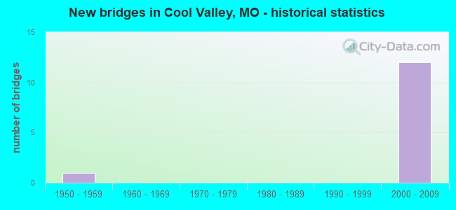
- New bridges - historical statistics
- 11950-1959
- 122000-2009


- Bridge Condition - Deck
- 20.0%Excellent
- 40.0%Good
- 40.0%Satisfactory
Find on map >> Show street view
Structure Number: 12037, Location: S 14 T 46 N R 6 E (Lat: 38.720667, Lng: -90.305722), Route carried "on" structure: Interstate 70, Year Built: 2001, Status: Open, Structure Length: 12.22m (40.09ft), Average Daily Traffic: 80,469 (year 2021), Truck Traffic: 18%, Average Future Daily Traffic: 100,586 (year 2041), Design Load: HS 25 or greater, Features Intersected: RT N, RP RTNN TO IS70W,
Minimum Vertical Clearance: 30+ m (98+ ft), Kilometerpoint: 386.996, Lanes on structure: 4, Lanes under structure: 8, Base Highway Network: Yes, Owner: State Highway Agency, Approaching Roadway Width: 20.1m (65.9ft), Material/Design: Steel continuous, Design/Construction: Stringer/Multi-beam, Number Of Spans In Main Unit: 3, Length of Maximum Span: 62.6m (205.4ft), Curb-To-Curb Width: 20.2m (66.3ft), Out-to-Out Width: 21.1m (69.2ft)
Condition: Deck: Satisfactory, Superstructure: Good, Substructure: Good, Operating Rating: 45.9 metric tons, Method Used To Determine Operating Rating: Load Factor (LF), Inventory Rating: 27.9 metric tons, Method Used To Determine Inventory Rating: Load Factor (LF), Structural Evaluation: Better than present minimum criteria, Deck Geometry: Equal to present minimum criteria, Underclear: Equal to present minimum criteria, Approach Roadway Alignment: Equal to present desirable criteria, Designated Inspection Frequency: Every 24 months, Inspection Date: September 2020, Deck Structure Type: Concrete Cast-file-Place, Wearing Surface/Protective System: Wearing Surface: Monolithic Concrete, Deck Protection: Epoxy Coated Reinforcing
Find on map >> Show street view
Structure Number: 12038, Location: S 14 T 46 N R 6 E (Lat: 38.720872, Lng: -90.305725), Route carried "on" structure: Interstate 70, Year Built: 2001, Status: Open, Structure Length: 12.22m (40.09ft), Average Daily Traffic: 74,182 (year 2021), Truck Traffic: 18%, Average Future Daily Traffic: 92,728 (year 2041), Design Load: HS 25 or greater, Features Intersected: RT N, RP RTNN TO IS70W,
Minimum Vertical Clearance: 30+ m (98+ ft), Kilometerpoint: 15.419, Lanes on structure: 3, Lanes under structure: 8, Base Highway Network: Yes, Owner: State Highway Agency, Approaching Roadway Width: 17.7m (58.1ft), Material/Design: Steel continuous, Design/Construction: Stringer/Multi-beam, Number Of Spans In Main Unit: 3, Length of Maximum Span: 62.6m (205.4ft), Curb-To-Curb Width: 17.8m (58.4ft), Out-to-Out Width: 18.7m (61.4ft)
Condition: Deck: Good, Superstructure: Good, Substructure: Good, Operating Rating: 89.1 metric tons, Method Used To Determine Operating Rating: Load Factor (LF), Inventory Rating: 37.8 metric tons, Method Used To Determine Inventory Rating: Load Factor (LF), Structural Evaluation: Better than present minimum criteria, Deck Geometry: Better than present minimum criteria, Underclear: Equal to present minimum criteria, Approach Roadway Alignment: Equal to present desirable criteria, Designated Inspection Frequency: Every 24 months, Inspection Date: September 2020, Deck Structure Type: Concrete Cast-file-Place, Wearing Surface/Protective System: Wearing Surface: Monolithic Concrete, Deck Protection: Epoxy Coated Reinforcing
Find on map >> Show street view
Structure Number: 12073, Location: S 14 T 46 N R 6 E (Lat: 38.720153, Lng: -90.312436), Route carried "on" structure: Ramp State highway , Year Built: 2001, Status: Open, Structure Length: 11.95m (39.21ft), Average Daily Traffic: 2,106 (year 2021), Truck Traffic: 3%, Average Future Daily Traffic: 2,633 (year 2041), Design Load: HS 25 or greater, Features Intersected: RP IS70E TO RTNN, Facility Carried by Structure: RP N HANLEY RD TO
Minimum Vertical Clearance: 30+ m (98+ ft), Kilometerpoint: 0.346, Lanes on structure: 1, Lanes under structure: 2, Base Highway Network: Yes, Owner: State Highway Agency, Approaching Roadway Width: 8.8m (28.9ft), Material/Design: Steel continuous, Design/Construction: Stringer/Multi-beam, Number Of Spans In Main Unit: 2, Length of Maximum Span: 61.1m (200.5ft), Curb-To-Curb Width: 9.0m (29.5ft), Out-to-Out Width: 9.8m (32.2ft)
Condition: Deck: Satisfactory, Superstructure: Good, Substructure: Good, Operating Rating: 86.4 metric tons, Method Used To Determine Operating Rating: Load Factor (LF), Inventory Rating: 52.2 metric tons, Method Used To Determine Inventory Rating: Load Factor (LF), Structural Evaluation: Better than present minimum criteria, Deck Geometry: Superior to present desirable criteria, Underclear: Better than present minimum criteria, Approach Roadway Alignment: Equal to present desirable criteria, Designated Inspection Frequency: Every 24 months, Critical Feature Inspection Frequency: Every 24 months, Inspection Date: March 2021, Critical Feature Inspection Date: March 2021, Deck Structure Type: Concrete Cast-file-Place, Wearing Surface/Protective System: Wearing Surface: Epoxy Overlay, Deck Protection: Epoxy Coated Reinforcing
Find on map >> Show street view
Structure Number: 12075, Location: S 14 T 46 N R 6 E (Lat: 38.720706, Lng: -90.309272), Route carried "on" structure: Interstate 70, Year Built: 2001, Status: Open, Structure Length: 0.66m (2.17ft), Average Daily Traffic: 145,087 (year 2021), Truck Traffic: 18%, Average Future Daily Traffic: 181,359 (year 2041), Design Load: HS 20, Features Intersected: DRAIN DTCH
Minimum Vertical Clearance: 30+ m (98+ ft), Kilometerpoint: 386.745, Lanes on structure: 13, Base Highway Network: Yes, Owner: State Highway Agency, Approaching Roadway Width: 60.4m (198.2ft), Skew: 33 degrees, Material/Design: Concrete continuous, Design/Construction: Culvert, Number Of Spans In Main Unit: 2, Length of Maximum Span: 2.7m (8.9ft), Curb or Sidewalk Widths: Left: 0.0m, Right: 1.8m (5.9ft)
Condition: Channel: Satisfactory, Culverts: Fair, Operating Rating: 47.7 metric tons, Method Used To Determine Operating Rating: Load Factor (LF), Inventory Rating: 28.8 metric tons, Method Used To Determine Inventory Rating: Load Factor (LF), Structural Evaluation: Somewhat better than minimum adequacy, Waterway Adequacy: Superior to present desirable criteria, Approach Roadway Alignment: Equal to present desirable criteria, Designated Inspection Frequency: Every 24 months, Inspection Date: November 2021
Find on map >> Show street view
Structure Number: 12144, Location: S 14 T 46 N R 6 E (Lat: 38.721764, Lng: -90.305583), Route carried "on" structure: Ramp State highway , Year Built: 2001, Status: Open, Structure Length: 10.45m (34.28ft), Average Daily Traffic: 2,669 (year 2021), Truck Traffic: 4%, Average Future Daily Traffic: 3,336 (year 2041), Design Load: HS 25 or greater, Features Intersected: RT N, RP RTNS TO IS70W,, Facility Carried by Structure: RP BERMUDA RD TO I
Minimum Vertical Clearance: 30+ m (98+ ft), Kilometerpoint: 0.800, Lanes on structure: 1, Lanes under structure: 7, Base Highway Network: Yes, Owner: State Highway Agency, Approaching Roadway Width: 9.4m (30.8ft), Material/Design: Steel continuous, Design/Construction: Stringer/Multi-beam, Number Of Spans In Main Unit: 4, Length of Maximum Span: 33.9m (111.2ft), Curb-To-Curb Width: 9.6m (31.5ft), Out-to-Out Width: 10.4m (34.1ft)
Condition: Deck: Good, Superstructure: Good, Substructure: Good, Operating Rating: 83.7 metric tons, Method Used To Determine Operating Rating: Load Factor (LF), Inventory Rating: 50.4 metric tons, Method Used To Determine Inventory Rating: Load Factor (LF), Structural Evaluation: Better than present minimum criteria, Deck Geometry: Superior to present desirable criteria, Underclear: Equal to present minimum criteria, Approach Roadway Alignment: Equal to present desirable criteria, Designated Inspection Frequency: Every 24 months, Inspection Date: September 2020, Deck Structure Type: Concrete Cast-file-Place, Wearing Surface/Protective System: Wearing Surface: Monolithic Concrete, Deck Protection: Epoxy Coated Reinforcing
Find on map >> Show street view
Structure Number: 4775, Location: S 29 T 51 N R 7 W (Lat: 39.164464, Lng: -91.704794), Route carried "on" structure: US 54, Year Built: 1956, Year Reconstructed: 2021, Status: Open, Structure Length: 3.63m (11.91ft), Average Daily Traffic: 4,505 (year 2021), Truck Traffic: 27%, Average Future Daily Traffic: 8,560 (year 2041), Design Load: H 20, Features Intersected: W FK CUIVRE RVR
Minimum Vertical Clearance: 30+ m (98+ ft), Kilometerpoint: 359.971, Lanes on structure: 2, Base Highway Network: Yes, Owner: State Highway Agency, Approaching Roadway Width: 7.3m (24.0ft), Material/Design: Steel, Design/Construction: Stringer/Multi-beam, Number Of Spans In Main Unit: 3, Length of Maximum Span: 12.2m (40.0ft), Curb-To-Curb Width: 9.4m (30.8ft), Out-to-Out Width: 9.6m (31.5ft)
Condition: Deck: Excellent, Superstructure: Good, Substructure: Good, Channel: Satisfactory, Operating Rating: 69.3 metric tons, Method Used To Determine Operating Rating: Load Factor (LF), Inventory Rating: 41.4 metric tons, Method Used To Determine Inventory Rating: Load Factor (LF), Structural Evaluation: Better than present minimum criteria, Deck Geometry: Meets minimum limits, Waterway Adequacy: Equal to present desirable criteria, Approach Roadway Alignment: Equal to present desirable criteria, Designated Inspection Frequency: Every 24 months, Inspection Date: October 2021, Deck Structure Type: Concrete Cast-file-Place, Wearing Surface/Protective System: Wearing Surface: Monolithic Concrete, Deck Protection: Epoxy Coated Reinforcing
Find on map >> Show street view
Structure Number: 12037, Location: S 14 T 46 N R 6 E (Lat: 38.720667, Lng: -90.305722), Route carried "under" structure: State highway N, Year Built: 2001, Structure Length: 0. m, Average Daily Traffic: 8,596 (year 2021), Truck Traffic: 4%, Features Intersected: RT N, Facility Carried by Structure: IS 70 E
Minimum Vertical Clearance: 5.11m (16.77ft), Kilometerpoint: 6.270, Lanes on structure: 4, Lanes under structure: 3, Material/Design: Steel continuous, Design/Construction: Stringer/Multi-beam, Length of Maximum Span: 62.6m (205.4ft)
Find on map >> Show street view
Structure Number: 12037, Location: S 14 T 46 N R 6 E (Lat: 38.720667, Lng: -90.305722), Route carried "under" structure: State highway N, Year Built: 2001, Structure Length: 0. m, Average Daily Traffic: 4,957 (year 2021), Truck Traffic: 2%, Features Intersected: RT N, Facility Carried by Structure: IS 70 E
Minimum Vertical Clearance: 5.11m (16.77ft), Kilometerpoint: 2.107, Lanes on structure: 4, Lanes under structure: 3, Material/Design: Steel continuous, Design/Construction: Stringer/Multi-beam, Length of Maximum Span: 62.6m (205.4ft)
Find on map >> Show street view
Structure Number: 12038, Location: S 14 T 46 N R 6 E (Lat: 38.720872, Lng: -90.305725), Route carried "under" structure: State highway N, Year Built: 2001, Structure Length: 0. m, Average Daily Traffic: 4,957 (year 2021), Truck Traffic: 2%, Features Intersected: RT N, Facility Carried by Structure: IS 70 W
Minimum Vertical Clearance: 5.21m (17.09ft), Kilometerpoint: 2.129, Lanes on structure: 3, Lanes under structure: 3, Material/Design: Steel continuous, Design/Construction: Stringer/Multi-beam, Length of Maximum Span: 62.6m (205.4ft)
Find on map >> Show street view
Structure Number: 12038, Location: S 14 T 46 N R 6 E (Lat: 38.720872, Lng: -90.305725), Route carried "under" structure: State highway N, Year Built: 2001, Structure Length: 0. m, Average Daily Traffic: 8,596 (year 2021), Truck Traffic: 4%, Features Intersected: RT N, Facility Carried by Structure: IS 70 W
Minimum Vertical Clearance: 5.21m (17.09ft), Kilometerpoint: 6.247, Lanes on structure: 3, Lanes under structure: 3, Material/Design: Steel continuous, Design/Construction: Stringer/Multi-beam, Length of Maximum Span: 62.6m (205.4ft)
Find on map >> Show street view
Structure Number: 12073, Location: S 14 T 46 N R 6 E (Lat: 38.720153, Lng: -90.312436), Route carried "under" structure: Ramp State highway , Year Built: 2001, Structure Length: 0. m, Average Daily Traffic: 5,108 (year 2021), Truck Traffic: 18%, Features Intersected: RP IS70E TO RTNN, Facility Carried by Structure: RP N HANLEY RD TO
Minimum Vertical Clearance: 5.13m (16.83ft), Kilometerpoint: 0.323, Lanes on structure: 1, Lanes under structure: 2, Material/Design: Steel continuous, Design/Construction: Stringer/Multi-beam, Length of Maximum Span: 61.1m (200.5ft)
Find on map >> Show street view
Structure Number: 12144, Location: S 14 T 46 N R 6 E (Lat: 38.721764, Lng: -90.305583), Route carried "under" structure: State highway N, Year Built: 2001, Structure Length: 0. m, Average Daily Traffic: 8,596 (year 2021), Truck Traffic: 4%, Features Intersected: RT N, Facility Carried by Structure: RP BERMUDA RD TO I
Minimum Vertical Clearance: 6.45m (21.16ft), Kilometerpoint: 6.148, Lanes on structure: 1, Lanes under structure: 3, Material/Design: Steel continuous, Design/Construction: Stringer/Multi-beam, Length of Maximum Span: 33.9m (111.2ft)
Find on map >> Show street view
Structure Number: 12144, Location: S 14 T 46 N R 6 E (Lat: 38.721764, Lng: -90.305583), Route carried "under" structure: State highway N, Year Built: 2001, Structure Length: 0. m, Average Daily Traffic: 8,598 (year 2021), Truck Traffic: 5%, Features Intersected: RT N, Facility Carried by Structure: RP BERMUDA RD TO I
Minimum Vertical Clearance: 6.40m (21.00ft), Kilometerpoint: 2.227, Lanes on structure: 1, Lanes under structure: 2, Material/Design: Steel continuous, Design/Construction: Stringer/Multi-beam, Length of Maximum Span: 33.9m (111.2ft)