Bridge Statistics for Clyde, Texas (TX)
Condition, Traffic, Stress, Structural Evaluation, Project Costs
- National Bridge Inventory (NBI) Statistics
- 26Number of bridges
- 180ft / 54.9mTotal length
- $151,000Total costs
- 232,995Total average daily traffic
- 62,585Total average daily truck traffic
- National Bridge Inventory (NBI) Registered Bridges for Clyde
- No street view available for this location
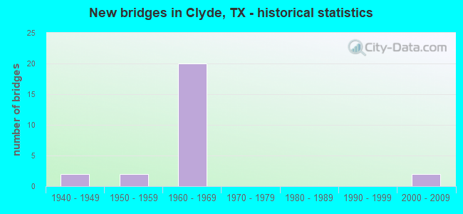
- New bridges - historical statistics
- 21940-1949
- 21950-1959
- 201960-1969
- 22000-2009

- Reconstructed bridges - Historical Statistics
- 11970-1979
- 31980-1989


- Bridge Condition - Deck
- 20.0%Good
- 70.0%Satisfactory
- 10.0%Fair

- Bridge Condition - Superstructure
- 20.0%Good
- 70.0%Satisfactory
- 10.0%Fair

- Bridge Condition - Substructure
- 50.0%Good
- 50.0%Satisfactory

- Bridge Condition - Culverts
- 16.7%Good
- 83.3%Satisfactory
Find on map >> Show street view
Structure Number: 80300000607047, Location: 3.25 MI E OF TAYLOR C/L (Lat: 32.427319, Lng: -99.576436), Route carried "on" structure: Interstate 20, Year Built: 1948, Year Reconstructed: 1994, Status: Open, Structure Length: 0.70m (2.30ft), Average Daily Traffic: 28,489 (year 2020), Truck Traffic: 27%, Average Future Daily Traffic: 33,470 (year 2033), Features Intersected: DRAW
Minimum Vertical Clearance: 30+ m (98+ ft), Kilometerpoint: 5.135, Lanes on structure: 5, Owner: State Highway Agency, Approaching Roadway Width: 23.2m (76.1ft), Skew: 20 degrees, Material/Design: Concrete, Design/Construction: Culvert, Number Of Spans In Main Unit: 4, Length of Maximum Span: 1.5m (4.9ft)
Condition: Channel: Good, Culverts: Satisfactory, Operating Rating: 32.7 metric tons, Method Used To Determine Operating Rating: Field evaluation and documented engineering judgment, Inventory Rating: 24.5 metric tons, Method Used To Determine Inventory Rating: Field evaluation and documented engineering judgment, Structural Evaluation: Equal to present minimum criteria, Waterway Adequacy: Equal to present minimum criteria, Approach Roadway Alignment: Equal to present desirable criteria, Designated Inspection Frequency: Every 24 months, Inspection Date: Febuary 2021
Find on map >> Show street view
Structure Number: 80300000607279, Location: 4.10 MI E of Taylor C/L (Lat: 32.424611, Lng: -99.561667), Route carried "on" structure: State highway 603, Year Built: 1964, Status: Open, Structure Length: 7.68m (25.20ft), Average Daily Traffic: 1,187 (year 2018), Truck Traffic: 18%, Average Future Daily Traffic: 1,470 (year 2033), Design Load: H 20, Features Intersected: IH 20
Minimum Vertical Clearance: 30+ m (98+ ft), Kilometerpoint: 0.035, Lanes on structure: 2, Lanes under structure: 4, Owner: State Highway Agency, Approaching Roadway Width: 7.3m (24.0ft), Skew: 1 degrees, Material/Design: Concrete continuous, Design/Construction: Tee Beam, Number Of Spans In Main Unit: 4, Length of Maximum Span: 21.3m (69.9ft), Curb-To-Curb Width: 7.4m (24.3ft), Out-to-Out Width: 8.3m (27.2ft)
Condition: Deck: Fair, Superstructure: Fair, Substructure: Satisfactory, Operating Rating: 40.8 metric tons, Method Used To Determine Operating Rating: Load Factor (LF), Inventory Rating: 24.5 metric tons, Method Used To Determine Inventory Rating: Load Factor (LF), Structural Evaluation: Somewhat better than minimum adequacy, Deck Geometry: Meets minimum limits, Underclear: Meets minimum limits, Approach Roadway Alignment: Equal to present desirable criteria, Length Of Structure Improvement: 7.68m (25.20ft), Designated Inspection Frequency: Every 24 months, Inspection Date: Febuary 2021, Bridge Improvement Cost: $121,000, Roadway Improvement Cost: $30,000, Total Project Cost: $151,000, Deck Structure Type: Concrete Cast-file-Place, Wearing Surface/Protective System: Wearing Surface: Bituminous
Find on map >> Show street view
Structure Number: 8030000060728, Location: 6.25 MI E of Taylor C/L (Lat: 32.418389, Lng: -99.525636), Route carried "on" structure: Interstate 20, Year Built: 1964, Status: Open, Structure Length: 3.47m (11.38ft), Average Daily Traffic: 16,496 (year 2019), Truck Traffic: 27%, Average Future Daily Traffic: 17,180 (year 2033), Design Load: HS 20, Features Intersected: FM 1707 / Hays Rd
Minimum Vertical Clearance: 30+ m (98+ ft), Kilometerpoint: 10.002, Lanes on structure: 2, Lanes under structure: 2, Owner: State Highway Agency, Approaching Roadway Width: 11.6m (38.1ft), Skew: 1 degrees, Material/Design: Concrete continuous, Design/Construction: Slab, Number Of Spans In Main Unit: 3, Length of Maximum Span: 13.7m (44.9ft), Curb-To-Curb Width: 11.4m (37.4ft), Out-to-Out Width: 12.3m (40.4ft)
Condition: Deck: Good, Superstructure: Good, Substructure: Satisfactory, Operating Rating: 50.8 metric tons, Method Used To Determine Operating Rating: Load Factor (LF), Inventory Rating: 30.8 metric tons, Method Used To Determine Inventory Rating: Load Factor (LF), Structural Evaluation: Equal to present minimum criteria, Deck Geometry: Somewhat better than minimum adequacy, Underclear: Somewhat better than minimum adequacy, Approach Roadway Alignment: Equal to present desirable criteria, Designated Inspection Frequency: Every 24 months, Inspection Date: Febuary 2021, Deck Structure Type: Concrete Cast-file-Place, Wearing Surface/Protective System: Wearing Surface: Bituminous
Find on map >> Show street view
Structure Number: 80300000607281, Location: 6.25 MI E of Taylor C/L (Lat: 32.418189, Lng: -99.525639), Route carried "on" structure: Interstate 20, Year Built: 1964, Status: Open, Structure Length: 3.47m (11.38ft), Average Daily Traffic: 16,621 (year 2019), Truck Traffic: 27%, Average Future Daily Traffic: 17,180 (year 2033), Design Load: HS 20, Features Intersected: FM 1707 / Hays Rd
Minimum Vertical Clearance: 30+ m (98+ ft), Kilometerpoint: 10.005, Lanes on structure: 2, Lanes under structure: 2, Owner: State Highway Agency, Approaching Roadway Width: 11.6m (38.1ft), Skew: 1 degrees, Material/Design: Concrete continuous, Design/Construction: Slab, Number Of Spans In Main Unit: 3, Length of Maximum Span: 13.7m (44.9ft), Curb-To-Curb Width: 11.4m (37.4ft), Out-to-Out Width: 12.3m (40.4ft)
Condition: Deck: Satisfactory, Superstructure: Satisfactory, Substructure: Satisfactory, Operating Rating: 50.8 metric tons, Method Used To Determine Operating Rating: Load Factor (LF), Inventory Rating: 30.8 metric tons, Method Used To Determine Inventory Rating: Load Factor (LF), Structural Evaluation: Equal to present minimum criteria, Deck Geometry: Somewhat better than minimum adequacy, Underclear: Somewhat better than minimum adequacy, Approach Roadway Alignment: Equal to present desirable criteria, Designated Inspection Frequency: Every 24 months, Inspection Date: Febuary 2021, Deck Structure Type: Concrete Cast-file-Place, Wearing Surface/Protective System: Wearing Surface: Bituminous
Find on map >> Show street view
Structure Number: 80300000607282, Location: 7.35 MI E OF TAYLOR C/L (Lat: 32.415317, Lng: -99.508219), Route carried "on" structure: Interstate 20, Year Built: 1965, Status: Open, Structure Length: 3.47m (11.38ft), Average Daily Traffic: 15,181 (year 2019), Truck Traffic: 27%, Average Future Daily Traffic: 17,180 (year 2033), Design Load: HS 20, Features Intersected: FM 604
Minimum Vertical Clearance: 30+ m (98+ ft), Kilometerpoint: 11.673, Lanes on structure: 2, Lanes under structure: 2, Owner: State Highway Agency, Approaching Roadway Width: 11.6m (38.1ft), Material/Design: Concrete continuous, Design/Construction: Slab, Number Of Spans In Main Unit: 3, Length of Maximum Span: 13.7m (44.9ft), Curb-To-Curb Width: 11.4m (37.4ft), Out-to-Out Width: 12.3m (40.4ft)
Condition: Deck: Satisfactory, Superstructure: Satisfactory, Substructure: Satisfactory, Operating Rating: 52.6 metric tons, Method Used To Determine Operating Rating: Load Factor (LF), Inventory Rating: 31.7 metric tons, Method Used To Determine Inventory Rating: Load Factor (LF), Structural Evaluation: Equal to present minimum criteria, Deck Geometry: Somewhat better than minimum adequacy, Underclear: Somewhat better than minimum adequacy, Approach Roadway Alignment: Equal to present desirable criteria, Designated Inspection Frequency: Every 24 months, Inspection Date: Febuary 2021, Deck Structure Type: Concrete Cast-file-Place
Find on map >> Show street view
Structure Number: 80300000607283, Location: 7.35 MI E OF TAYLOR C/L (Lat: 32.415125, Lng: -99.508283), Route carried "on" structure: Interstate 20, Year Built: 1964, Status: Open, Structure Length: 3.47m (11.38ft), Average Daily Traffic: 14,950 (year 2019), Truck Traffic: 27%, Average Future Daily Traffic: 17,180 (year 2033), Design Load: HS 20, Features Intersected: FM 604
Minimum Vertical Clearance: 30+ m (98+ ft), Kilometerpoint: 11.673, Lanes on structure: 2, Lanes under structure: 2, Owner: State Highway Agency, Approaching Roadway Width: 11.6m (38.1ft), Material/Design: Concrete continuous, Design/Construction: Slab, Number Of Spans In Main Unit: 3, Length of Maximum Span: 13.7m (44.9ft), Curb-To-Curb Width: 11.4m (37.4ft), Out-to-Out Width: 12.3m (40.4ft)
Condition: Deck: Satisfactory, Superstructure: Satisfactory, Substructure: Good, Operating Rating: 52.6 metric tons, Method Used To Determine Operating Rating: Load Factor (LF), Inventory Rating: 31.7 metric tons, Method Used To Determine Inventory Rating: Load Factor (LF), Structural Evaluation: Equal to present minimum criteria, Deck Geometry: Somewhat better than minimum adequacy, Underclear: Somewhat better than minimum adequacy, Approach Roadway Alignment: Equal to present desirable criteria, Designated Inspection Frequency: Every 24 months, Inspection Date: Febuary 2021, Deck Structure Type: Concrete Cast-file-Place
Find on map >> Show street view
Structure Number: 80300000607284, Location: 7.80 MI E OF TAYLOR C/L (Lat: 32.414269, Lng: -99.501072), Route carried "on" structure: Interstate 20, Year Built: 1947, Year Reconstructed: 1992, Status: Open, Structure Length: 0.67m (2.20ft), Average Daily Traffic: 25,672 (year 2020), Truck Traffic: 27%, Average Future Daily Traffic: 27,370 (year 2033), Design Load: H 15, Features Intersected: DRAW
Minimum Vertical Clearance: 30+ m (98+ ft), Kilometerpoint: 12.374, Lanes on structure: 6, Owner: State Highway Agency, Approaching Roadway Width: 30.5m (100.1ft), Skew: 29 degrees, Material/Design: Concrete, Design/Construction: Culvert, Number Of Spans In Main Unit: 3, Length of Maximum Span: 1.5m (4.9ft)
Condition: Channel: Good, Culverts: Satisfactory, Operating Rating: 39.9 metric tons, Method Used To Determine Operating Rating: Load Factor (LF), Inventory Rating: 23.6 metric tons, Method Used To Determine Inventory Rating: Load Factor (LF), Structural Evaluation: Somewhat better than minimum adequacy, Waterway Adequacy: Equal to present minimum criteria, Approach Roadway Alignment: Equal to present desirable criteria, Designated Inspection Frequency: Every 24 months, Inspection Date: Febuary 2021
Find on map >> Show street view
Structure Number: 80300000607285, Location: 7.7 MI E OF TAYLOR C/L (Lat: 32.413617, Lng: -99.500994), Route carried "on" structure: ServiceInterstate 20, Year Built: 1964, Status: Open, Structure Length: 0.67m (2.20ft), Average Daily Traffic: 2,870 (year 2013), Truck Traffic: 28%, Average Future Daily Traffic: 4,020 (year 2033), Design Load: HS 20, Features Intersected: DRAW
Minimum Vertical Clearance: 30+ m (98+ ft), Kilometerpoint: 12.392, Lanes on structure: 2, Owner: State Highway Agency, Approaching Roadway Width: 9.1m (29.9ft), Skew: 4 degrees, Material/Design: Concrete, Design/Construction: Culvert, Number Of Spans In Main Unit: 3, Length of Maximum Span: 1.5m (4.9ft)
Condition: Channel: Good, Culverts: Satisfactory, Operating Rating: 39.9 metric tons, Method Used To Determine Operating Rating: Load Factor (LF), Inventory Rating: 23.6 metric tons, Method Used To Determine Inventory Rating: Load Factor (LF), Structural Evaluation: Equal to present minimum criteria, Waterway Adequacy: Equal to present minimum criteria, Approach Roadway Alignment: Equal to present desirable criteria, Designated Inspection Frequency: Every 24 months, Inspection Date: Febuary 2021
Find on map >> Show street view
Structure Number: 80300000607286, Location: 8.50 MI E of Taylor C/L (Lat: 32.412044, Lng: -99.489681), Route carried "on" structure: Interstate 20, Year Built: 1964, Status: Open, Structure Length: 3.47m (11.38ft), Average Daily Traffic: 13,257 (year 2019), Truck Traffic: 27%, Average Future Daily Traffic: 13,680 (year 2033), Design Load: HS 20, Features Intersected: Cherry Ln / CR 113
Minimum Vertical Clearance: 30+ m (98+ ft), Kilometerpoint: 13.456, Lanes on structure: 2, Lanes under structure: 2, Owner: State Highway Agency, Approaching Roadway Width: 11.6m (38.1ft), Skew: 1 degrees, Material/Design: Concrete continuous, Design/Construction: Slab, Number Of Spans In Main Unit: 3, Length of Maximum Span: 13.7m (44.9ft), Curb-To-Curb Width: 11.4m (37.4ft), Out-to-Out Width: 12.3m (40.4ft)
Condition: Deck: Satisfactory, Superstructure: Satisfactory, Substructure: Good, Operating Rating: 52.6 metric tons, Method Used To Determine Operating Rating: Load Factor (LF), Inventory Rating: 31.7 metric tons, Method Used To Determine Inventory Rating: Load Factor (LF), Structural Evaluation: Equal to present minimum criteria, Deck Geometry: Somewhat better than minimum adequacy, Underclear: Meets minimum limits, Approach Roadway Alignment: Equal to present desirable criteria, Designated Inspection Frequency: Every 24 months, Inspection Date: Febuary 2021, Deck Structure Type: Concrete Cast-file-Place
Find on map >> Show street view
Structure Number: 80300000607287, Location: 8.50 MI E of Taylor C/L (Lat: 32.411842, Lng: -99.489678), Route carried "on" structure: Interstate 20, Year Built: 1964, Status: Open, Structure Length: 3.47m (11.38ft), Average Daily Traffic: 13,720 (year 2019), Truck Traffic: 27%, Average Future Daily Traffic: 13,680 (year 2033), Design Load: HS 20, Features Intersected: Cherry Ln / CR 113
Minimum Vertical Clearance: 30+ m (98+ ft), Kilometerpoint: 13.456, Lanes on structure: 2, Lanes under structure: 2, Owner: State Highway Agency, Approaching Roadway Width: 11.6m (38.1ft), Skew: 1 degrees, Material/Design: Concrete continuous, Design/Construction: Slab, Number Of Spans In Main Unit: 3, Length of Maximum Span: 13.7m (44.9ft), Curb-To-Curb Width: 11.4m (37.4ft), Out-to-Out Width: 12.3m (40.4ft)
Condition: Deck: Satisfactory, Superstructure: Satisfactory, Substructure: Satisfactory, Operating Rating: 52.6 metric tons, Method Used To Determine Operating Rating: Load Factor (LF), Inventory Rating: 31.7 metric tons, Method Used To Determine Inventory Rating: Load Factor (LF), Structural Evaluation: Equal to present minimum criteria, Deck Geometry: Somewhat better than minimum adequacy, Underclear: Meets minimum limits, Approach Roadway Alignment: Equal to present desirable criteria, Designated Inspection Frequency: Every 24 months, Inspection Date: Febuary 2021, Deck Structure Type: Concrete Cast-file-Place
Find on map >> Show street view
Structure Number: 80300000607288, Location: 9.5 MI E OF TAYLOR CO LN (Lat: 32.409644, Lng: -99.470461), Route carried "on" structure: Interstate 20, Year Built: 1964, Status: Open, Structure Length: 0.70m (2.30ft), Average Daily Traffic: 22,984 (year 2020), Truck Traffic: 29%, Average Future Daily Traffic: 28,700 (year 2033), Features Intersected: DRAW
Minimum Vertical Clearance: 30+ m (98+ ft), Kilometerpoint: 15.298, Lanes on structure: 4, Owner: State Highway Agency, Approaching Roadway Width: 23.2m (76.1ft), Skew: 20 degrees, Material/Design: Concrete, Design/Construction: Culvert, Number Of Spans In Main Unit: 4, Length of Maximum Span: 1.5m (4.9ft)
Condition: Channel: Good, Culverts: Satisfactory, Operating Rating: 32.7 metric tons, Method Used To Determine Operating Rating: Field evaluation and documented engineering judgment, Inventory Rating: 24.5 metric tons, Method Used To Determine Inventory Rating: Field evaluation and documented engineering judgment, Structural Evaluation: Equal to present minimum criteria, Waterway Adequacy: Equal to present minimum criteria, Approach Roadway Alignment: Equal to present desirable criteria, Designated Inspection Frequency: Every 24 months, Inspection Date: Febuary 2021
Find on map >> Show street view
Structure Number: 8030000060729, Location: 10.40 MI E of Taylor C/L (Lat: 32.407736, Lng: -99.454758), Route carried "on" structure: Interstate 20, Year Built: 1964, Status: Open, Structure Length: 3.47m (11.38ft), Average Daily Traffic: 13,257 (year 2019), Truck Traffic: 29%, Average Future Daily Traffic: 14,350 (year 2033), Design Load: HS 20, Features Intersected: Union Hill Rd / CR 119
Minimum Vertical Clearance: 30+ m (98+ ft), Kilometerpoint: 16.795, Lanes on structure: 2, Lanes under structure: 2, Owner: State Highway Agency, Approaching Roadway Width: 11.6m (38.1ft), Skew: 1 degrees, Material/Design: Concrete continuous, Design/Construction: Slab, Number Of Spans In Main Unit: 3, Length of Maximum Span: 13.7m (44.9ft), Curb-To-Curb Width: 11.4m (37.4ft), Out-to-Out Width: 12.3m (40.4ft)
Condition: Deck: Satisfactory, Superstructure: Satisfactory, Substructure: Good, Operating Rating: 52.6 metric tons, Method Used To Determine Operating Rating: Load Factor (LF), Inventory Rating: 31.7 metric tons, Method Used To Determine Inventory Rating: Load Factor (LF), Structural Evaluation: Equal to present minimum criteria, Deck Geometry: Somewhat better than minimum adequacy, Underclear: Meets minimum limits, Approach Roadway Alignment: Equal to present desirable criteria, Designated Inspection Frequency: Every 24 months, Inspection Date: Febuary 2021, Deck Structure Type: Concrete Cast-file-Place
Find on map >> Show street view
Structure Number: 80300000607291, Location: 10.40 MI E of Taylor C/L (Lat: 32.407536, Lng: -99.454744), Route carried "on" structure: Interstate 20, Year Built: 1964, Status: Open, Structure Length: 3.47m (11.38ft), Average Daily Traffic: 13,720 (year 2019), Truck Traffic: 29%, Average Future Daily Traffic: 14,350 (year 2033), Design Load: HS 20, Features Intersected: Union Hill Rd / CR 279
Minimum Vertical Clearance: 30+ m (98+ ft), Kilometerpoint: 16.795, Lanes on structure: 2, Lanes under structure: 2, Owner: State Highway Agency, Approaching Roadway Width: 11.6m (38.1ft), Skew: 1 degrees, Material/Design: Concrete continuous, Design/Construction: Slab, Number Of Spans In Main Unit: 3, Length of Maximum Span: 13.7m (44.9ft), Curb-To-Curb Width: 11.4m (37.4ft), Out-to-Out Width: 12.3m (40.4ft)
Condition: Deck: Satisfactory, Superstructure: Satisfactory, Substructure: Good, Operating Rating: 52.6 metric tons, Method Used To Determine Operating Rating: Load Factor (LF), Inventory Rating: 31.7 metric tons, Method Used To Determine Inventory Rating: Load Factor (LF), Structural Evaluation: Equal to present minimum criteria, Deck Geometry: Somewhat better than minimum adequacy, Underclear: Meets minimum limits, Approach Roadway Alignment: Equal to present desirable criteria, Designated Inspection Frequency: Every 24 months, Inspection Date: Febuary 2021, Deck Structure Type: Concrete Cast-file-Place
Find on map >> Show street view
Structure Number: 8030000061104, Location: 1.35 MI E of FM 604 (Lat: 32.386883, Lng: -99.485147), Route carried "on" structure: State highway 18, Year Built: 1951, Year Reconstructed: 1981, Status: Open, Structure Length: 0.70m (2.30ft), Average Daily Traffic: 1,020 (year 2020), Truck Traffic: 19%, Average Future Daily Traffic: 1,040 (year 2033), Features Intersected: Tabors Draw
Minimum Vertical Clearance: 30+ m (98+ ft), Kilometerpoint: 16.048, Lanes on structure: 2, Owner: State Highway Agency, Approaching Roadway Width: 9.8m (32.2ft), Material/Design: Concrete, Design/Construction: Culvert, Number Of Spans In Main Unit: 4, Length of Maximum Span: 1.5m (4.9ft), Curb-To-Curb Width: 17.1m (56.1ft), Out-to-Out Width: 17.5m (57.4ft)
Condition: Channel: Good, Culverts: Good, Operating Rating: 32.7 metric tons, Method Used To Determine Operating Rating: Field evaluation and documented engineering judgment, Inventory Rating: 24.5 metric tons, Method Used To Determine Inventory Rating: Field evaluation and documented engineering judgment, Structural Evaluation: Equal to present minimum criteria, Deck Geometry: Superior to present desirable criteria, Waterway Adequacy: Equal to present minimum criteria, Approach Roadway Alignment: Equal to present desirable criteria, Designated Inspection Frequency: Every 24 months, Inspection Date: Febuary 2021, Deck Structure Type: Concrete Cast-file-Place, Wearing Surface/Protective System: Wearing Surface: Bituminous
Find on map >> Show street view
Structure Number: 80300000611339, Location: 0.50 MI S OF IH 20 (Lat: 32.408497, Lng: -99.507656), Route carried "on" structure: State highway 604, Year Built: 2007, Status: Open, Structure Length: 15.24m (50.00ft), Average Daily Traffic: 1,275 (year 2013), Truck Traffic: 12%, Average Future Daily Traffic: 1,450 (year 2033), Design Load: HS 20, Features Intersected: FM 18 / UPRR / N 1ST ST
Minimum Vertical Clearance: 30+ m (98+ ft), Kilometerpoint: 15.899, Lanes on structure: 2, Lanes under structure: 4, Owner: State Highway Agency, Approaching Roadway Width: 17.1m (56.1ft), Skew: 31 degrees, Material/Design: Prestressed concrete, Design/Construction: Stringer/Multi-beam, Number Of Spans In Main Unit: 5, Length of Maximum Span: 32.0m (105.0ft), Curb-To-Curb Width: 16.9m (55.4ft), Out-to-Out Width: 18.3m (60.0ft)
Condition: Deck: Good, Superstructure: Good, Substructure: Good, Operating Rating: 54.4 metric tons, Method Used To Determine Operating Rating: Load Factor (LF), Inventory Rating: 32.7 metric tons, Method Used To Determine Inventory Rating: Assigned rating based on Load Factor Design (LFD) reported in metric tons, Structural Evaluation: Better than present minimum criteria, Deck Geometry: Superior to present desirable criteria, Underclear: Superior to present desirable criteria, Approach Roadway Alignment: Equal to present desirable criteria, Designated Inspection Frequency: Every 24 months, Inspection Date: Febuary 2021, Deck Structure Type: Concrete Precast Panels
Find on map >> Show street view
Structure Number: 80300097401008, Location: 4.55 MI S OF IH 20 (Lat: 32.356011, Lng: -99.508214), Route carried "on" structure: State highway 604, Year Built: 1955, Year Reconstructed: 1989, Status: Open, Structure Length: 0.79m (2.59ft), Average Daily Traffic: 386 (year 2020), Truck Traffic: 19%, Average Future Daily Traffic: 490 (year 2033), Features Intersected: Draw
Minimum Vertical Clearance: 30+ m (98+ ft), Kilometerpoint: 8.682, Lanes on structure: 2, Owner: State Highway Agency, Approaching Roadway Width: 8.5m (27.9ft), Material/Design: Concrete, Design/Construction: Culvert, Number Of Spans In Main Unit: 3, Length of Maximum Span: 2.4m (7.9ft), Curb-To-Curb Width: 9.1m (29.9ft), Out-to-Out Width: 9.5m (31.2ft)
Condition: Channel: Good, Culverts: Satisfactory, Operating Rating: 39.9 metric tons, Method Used To Determine Operating Rating: Load Factor (LF), Inventory Rating: 23.6 metric tons, Method Used To Determine Inventory Rating: Load Factor (LF), Structural Evaluation: Equal to present minimum criteria, Deck Geometry: Equal to present minimum criteria, Waterway Adequacy: Equal to present minimum criteria, Approach Roadway Alignment: Equal to present desirable criteria, Designated Inspection Frequency: Every 24 months, Inspection Date: Febuary 2021, Deck Structure Type: Concrete Cast-file-Place, Wearing Surface/Protective System: Wearing Surface: Bituminous
Find on map >> Show street view
Structure Number: 80300000607279, Location: 4.10 MI E of Taylor C/L (Lat: 32.424611, Lng: -99.561667), Route carried "under" structure: Interstate 20, Year Built: 1964, Structure Length: 0. m, Average Daily Traffic: 23,910 (year 2013), Truck Traffic: 27%, Features Intersected: IH 20, Facility Carried by Structure: FM 603
Minimum Vertical Clearance: 5.05m (16.57ft), Kilometerpoint: 6.558, Lanes on structure: 2, Lanes under structure: 4, Material/Design: Concrete continuous, Design/Construction: Tee Beam, Length of Maximum Span: 21.3m (69.9ft)
Find on map >> Show street view
Structure Number: 8030000060728, Location: 6.25 MI E of Taylor C/L (Lat: 32.418389, Lng: -99.525636), Route carried "under" structure: State highway 1707, Year Built: 1964, Structure Length: 0. m, Average Daily Traffic: 1,010 (year 2013), Truck Traffic: 20%, Features Intersected: FM 1707 / Hays Rd, Facility Carried by Structure: IH 20 WB
Minimum Vertical Clearance: 4.62m (15.16ft), Kilometerpoint: 0.000, Lanes on structure: 2, Lanes under structure: 2, Material/Design: Concrete continuous, Design/Construction: Slab, Length of Maximum Span: 13.7m (44.9ft)
Find on map >> Show street view
Structure Number: 80300000607281, Location: 6.25 MI E of Taylor C/L (Lat: 32.418189, Lng: -99.525639), Route carried "under" structure: State highway 1707, Year Built: 1964, Structure Length: 0. m, Average Daily Traffic: 1,010 (year 2013), Truck Traffic: 20%, Features Intersected: FM 1707 / Hays Rd, Facility Carried by Structure: IH 20 EB
Minimum Vertical Clearance: 4.52m (14.83ft), Kilometerpoint: 0.000, Lanes on structure: 2, Lanes under structure: 2, Material/Design: Concrete continuous, Design/Construction: Slab, Length of Maximum Span: 13.7m (44.9ft)
Find on map >> Show street view
Structure Number: 80300000607282, Location: 7.35 MI E OF TAYLOR C/L (Lat: 32.415317, Lng: -99.508219), Route carried "under" structure: State highway 604, Year Built: 1965, Structure Length: 0. m, Average Daily Traffic: 760 (year 2013), Truck Traffic: 19%, Features Intersected: FM 604, Facility Carried by Structure: IH 20 WB
Minimum Vertical Clearance: 4.42m (14.50ft), Kilometerpoint: 13.248, Lanes on structure: 2, Lanes under structure: 2, Material/Design: Concrete continuous, Design/Construction: Slab, Length of Maximum Span: 13.7m (44.9ft)
Find on map >> Show street view
Structure Number: 80300000607283, Location: 7.35 MI E OF TAYLOR C/L (Lat: 32.415125, Lng: -99.508283), Route carried "under" structure: State highway 604, Year Built: 1964, Structure Length: 0. m, Average Daily Traffic: 760 (year 2013), Truck Traffic: 19%, Features Intersected: FM 604, Facility Carried by Structure: IH 20 EB
Minimum Vertical Clearance: 4.67m (15.32ft), Kilometerpoint: 13.271, Lanes on structure: 2, Lanes under structure: 2, Material/Design: Concrete continuous, Design/Construction: Slab, Length of Maximum Span: 13.7m (44.9ft)
Find on map >> Show street view
Structure Number: 80300000607286, Location: 8.50 MI E of Taylor C/L (Lat: 32.412044, Lng: -99.489681), Route carried "under" structure: County highway 113, Year Built: 1964, Structure Length: 0. m, Average Daily Traffic: 200 (year 2013), Truck Traffic: 3%, Features Intersected: Cherry Ln / CR 113, Facility Carried by Structure: IH 20 WB
Minimum Vertical Clearance: 4.44m (14.57ft), Kilometerpoint: 0.000, Lanes on structure: 2, Lanes under structure: 2, Material/Design: Concrete continuous, Design/Construction: Slab, Length of Maximum Span: 13.7m (44.9ft)
Find on map >> Show street view
Structure Number: 80300000607287, Location: 8.50 MI E of Taylor C/L (Lat: 32.411842, Lng: -99.489678), Route carried "under" structure: County highway 113, Year Built: 1964, Structure Length: 0. m, Average Daily Traffic: 200 (year 2013), Truck Traffic: 3%, Features Intersected: Cherry Ln / CR 113, Facility Carried by Structure: IH 20 EB
Minimum Vertical Clearance: 4.83m (15.85ft), Kilometerpoint: 0.000, Lanes on structure: 2, Lanes under structure: 2, Material/Design: Concrete continuous, Design/Construction: Slab, Length of Maximum Span: 13.7m (44.9ft)
Find on map >> Show street view
Structure Number: 8030000060729, Location: 10.40 MI E of Taylor C/L (Lat: 32.407736, Lng: -99.454758), Route carried "under" structure: County highway 279, Year Built: 1964, Structure Length: 0. m, Average Daily Traffic: 200 (year 2013), Truck Traffic: 3%, Features Intersected: Union Hill Rd / CR 119, Facility Carried by Structure: IH 20 WB
Minimum Vertical Clearance: 4.42m (14.50ft), Kilometerpoint: 0.000, Lanes on structure: 2, Lanes under structure: 2, Material/Design: Concrete continuous, Design/Construction: Slab, Length of Maximum Span: 13.7m (44.9ft)
Find on map >> Show street view
Structure Number: 80300000607291, Location: 10.40 MI E of Taylor C/L (Lat: 32.407536, Lng: -99.454744), Route carried "under" structure: County highway 279, Year Built: 1964, Structure Length: 0. m, Average Daily Traffic: 200 (year 2013), Truck Traffic: 3%, Features Intersected: Union Hill Rd / CR 279, Facility Carried by Structure: IH 20 EB
Minimum Vertical Clearance: 4.93m (16.17ft), Kilometerpoint: 0.000, Lanes on structure: 2, Lanes under structure: 2, Material/Design: Concrete continuous, Design/Construction: Slab, Length of Maximum Span: 13.7m (44.9ft)
Find on map >> Show street view
Structure Number: 80300000611339, Location: 0.50 MI S OF IH 20 (Lat: 32.407567, Lng: -99.507547), Route carried "under" structure: State highway 18, Year Built: 2007, Structure Length: 0. m, Average Daily Traffic: 3,660 (year 2013), Truck Traffic: 14%, Features Intersected: FM 18 / UPRR / N 1ST ST, Facility Carried by Structure: FM 604
Minimum Vertical Clearance: 7.14m (23.43ft), Kilometerpoint: 0.042, Lanes on structure: 2, Lanes under structure: 4, Material/Design: Prestressed concrete, Design/Construction: Stringer/Multi-beam, Length of Maximum Span: 32.0m (105.0ft)