Bridge Statistics for Chelyan, West Virginia (WV)
Condition, Traffic, Stress, Structural Evaluation, Project Costs
- National Bridge Inventory (NBI) Statistics
- 20Number of bridges
- 509ft / 155mTotal length
- $1,875,000Total costs
- 168,060Total average daily traffic
- 29,594Total average daily truck traffic
- National Bridge Inventory (NBI) Registered Bridges for Chelyan
- No street view available for this location
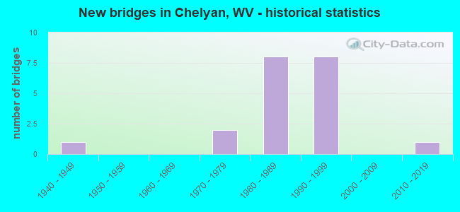
- New bridges - historical statistics
- 11940-1949
- 21970-1979
- 81980-1989
- 81990-1999
- 12010-2019


- Bridge Condition - Deck
- 46.2%Good
- 15.4%Satisfactory
- 30.8%Fair
- 7.7%Poor

- Bridge Condition - Superstructure
- 7.7%Very good
- 30.8%Good
- 38.5%Satisfactory
- 15.4%Fair
- 7.7%Serious

- Bridge Condition - Substructure
- 15.4%Very good
- 30.8%Good
- 38.5%Satisfactory
- 15.4%Fair

- Bridge Condition - Channel
- 10.0%Excellent
- 50.0%Very good
- 20.0%Good
- 10.0%Fair
- 10.0%Serious
Find on map >> Show street view
Structure Number: 20A175, Location: 0.34 MI E OF US 60 (Lat: 38.207369, Lng: -81.498261), Route carried "on" structure: County highway 6019, Year Built: 1975, Status: Open, Structure Length: 0.69m (2.26ft), Average Daily Traffic: 450 (year 2018), Truck Traffic: 5%, Average Future Daily Traffic: 549 (year 2038), Design Load: HS 20, Features Intersected: CARROLL BRANCH, Facility Carried by Structure: COUNTY ROUTE 60/19
Minimum Vertical Clearance: 30+ m (98+ ft), Kilometerpoint: 0.547, Lanes on structure: 1, Owner: State Highway Agency, Approaching Roadway Width: 3.4m (11.2ft), Skew: 1 degrees, Material/Design: Prestressed concrete, Design/Construction: Slab, Number Of Spans In Main Unit: 1, Length of Maximum Span: 6.1m (20.0ft), Curb-To-Curb Width: 4.7m (15.4ft), Out-to-Out Width: 4.9m (16.1ft)
Condition: Deck: Good, Superstructure: Good, Substructure: Fair, Channel: Fair, Operating Rating: 76.2 metric tons, Method Used To Determine Operating Rating: Load Factor (LF), Inventory Rating: 45.4 metric tons, Method Used To Determine Inventory Rating: Load Factor (LF), Structural Evaluation: Somewhat better than minimum adequacy, Deck Geometry: High priority of replacement, Waterway Adequacy: Equal to present minimum criteria, Approach Roadway Alignment: High priority of corrective action, Length Of Structure Improvement: 0.69m (2.26ft), Designated Inspection Frequency: Every 24 months, Inspection Date: March 2020, Deck Structure Type: Other, Wearing Surface/Protective System: Wearing Surface: Monolithic Concrete
Find on map >> Show street view
Structure Number: 20A18, Location: 0.49 MI N OF CR 61/9 (Lat: 38.197081, Lng: -81.478731), Route carried "on" structure: State highway 61, Year Built: 1985, Status: Open, Structure Length: 4.45m (14.60ft), Average Daily Traffic: 3,500 (year 2020), Truck Traffic: 6%, Average Future Daily Traffic: 4,270 (year 2040), Design Load: HS 20+Mod, Features Intersected: CABIN CREEK
Minimum Vertical Clearance: 30+ m (98+ ft), Kilometerpoint: 16.721, Lanes on structure: 2, Owner: State Highway Agency, Approaching Roadway Width: 10.1m (33.1ft), Material/Design: Steel, Design/Construction: Stringer/Multi-beam, Number Of Spans In Main Unit: 1, Length of Maximum Span: 42.7m (140.1ft), Curb or Sidewalk Widths: Left: 0.0m, Right: 1.3m (4.3ft), Curb-To-Curb Width: 9.4m (30.8ft), Out-to-Out Width: 11.9m (39.0ft)
Condition: Deck: Good, Superstructure: Satisfactory, Substructure: Good, Channel: Very good, Operating Rating: 88.9 metric tons, Method Used To Determine Operating Rating: Load Factor (LF), Inventory Rating: 62.6 metric tons, Method Used To Determine Inventory Rating: Load Factor (LF), Structural Evaluation: Equal to present minimum criteria, Deck Geometry: Meets minimum limits, Waterway Adequacy: Equal to present minimum criteria, Approach Roadway Alignment: Equal to present desirable criteria, Length Of Structure Improvement: 4.45m (14.60ft), Designated Inspection Frequency: Every 24 months, Inspection Date: July 2021, Deck Structure Type: Concrete Cast-file-Place, Wearing Surface/Protective System: Wearing Surface: Monolithic Concrete, Deck Protection: Epoxy Coated Reinforcing
Find on map >> Show street view
Structure Number: 20A25, Location: 0.17 MI N OF CR 79/1 (Lat: 38.182139, Lng: -81.468369), Route carried "on" structure: County highway 793, Year Built: 1991, Status: Posted for load, Structure Length: 4.83m (15.85ft), Average Daily Traffic: 6,200 (year 2020), Truck Traffic: 5%, Average Future Daily Traffic: 8,122 (year 2040), Design Load: HS 25 or greater, Features Intersected: CABIN CREEK, Facility Carried by Structure: COUNTY ROUTE 79/3
Minimum Vertical Clearance: 30+ m (98+ ft), Kilometerpoint: 27.616, Lanes on structure: 2, Owner: State Highway Agency, Approaching Roadway Width: 7.0m (23.0ft), Skew: 4 degrees, Material/Design: Prestressed concrete, Design/Construction: Box Beam or Girders - Multiple, Number Of Spans In Main Unit: 2, Length of Maximum Span: 23.2m (76.1ft), Curb-To-Curb Width: 9.4m (30.8ft), Out-to-Out Width: 10.2m (33.5ft)
Condition: Deck: Poor, Superstructure: Serious, Substructure: Very good, Channel: Good, Operating Rating: 46.3 metric tons, Method Used To Determine Operating Rating: Load Factor (LF), Inventory Rating: 28.1 metric tons, Method Used To Determine Inventory Rating: Load Factor (LF), Structural Evaluation: High priority of corrective action, Deck Geometry: High priority of corrective action, Waterway Adequacy: Equal to present minimum criteria, Approach Roadway Alignment: Equal to present desirable criteria, Bridge Posting: Required (Relationship of Operating Rating to Maximum Legal Load: 10.0 - 19.9% below), Length Of Structure Improvement: 4.83m (15.85ft), Designated Inspection Frequency: Every 24 months, Other Special Inspection Frequency: Every 3 months, Inspection Date: April 2021, Other Special Inspection Date: December 2021, Bridge Improvement Cost: $650,000, Roadway Improvement Cost: $100,000, Total Project Cost: $750,000 ( Estimate for 2021), Deck Structure Type: Other, Wearing Surface/Protective System: Wearing Surface: Bituminous, Deck Protection: Epoxy Coated Reinforcing
Find on map >> Show street view
Structure Number: 20A521, Location: 0.25 MI E OF CR 79/3 (Lat: 38.183319, Lng: -81.476011), Route carried "on" structure: County highway 798, Year Built: 1978, Status: Open, Structure Length: 3.72m (12.20ft), Average Daily Traffic: 20 (year 2020), Truck Traffic: 5%, Average Future Daily Traffic: 26 (year 2040), Design Load: H 15, Features Intersected: CABIN CREEK, Facility Carried by Structure: CR 79/8
Minimum Vertical Clearance: 30+ m (98+ ft), Kilometerpoint: 0.402, Lanes on structure: 1, Owner: State Highway Agency, Approaching Roadway Width: 3.4m (11.2ft), Skew: 2 degrees, Material/Design: Steel, Design/Construction: Stringer/Multi-beam, Number Of Spans In Main Unit: 2, Length of Maximum Span: 17.7m (58.1ft), Curb-To-Curb Width: 4.3m (14.1ft), Out-to-Out Width: 4.3m (14.1ft)
Condition: Deck: Fair, Superstructure: Fair, Substructure: Fair, Channel: Serious, Operating Rating: 56.2 metric tons, Method Used To Determine Operating Rating: Load Factor (LF), Inventory Rating: 33.6 metric tons, Method Used To Determine Inventory Rating: Load Factor (LF), Structural Evaluation: Somewhat better than minimum adequacy, Deck Geometry: Equal to present minimum criteria, Waterway Adequacy: Equal to present minimum criteria, Approach Roadway Alignment: Equal to present minimum criteria, Length Of Structure Improvement: 3.72m (12.20ft), Designated Inspection Frequency: Every 24 months, Inspection Date: September 2021, Bridge Improvement Cost: $200,000, Roadway Improvement Cost: $50,000, Total Project Cost: $250,000 ( Estimate for 2021), Deck Structure Type: Wood or Timber, Wearing Surface/Protective System: Wearing Surface: Bituminous
Find on map >> Show street view
Structure Number: 20A608, Location: 0.0 MI. N. FROM CO.RT.8 (Lat: 38.158369, Lng: -81.445811), Route carried "on" structure: Interstate 7700, Year Built: 1986, Status: Open, Structure Length: 5.71m (18.73ft), Average Daily Traffic: 20,942 (year 2018), Truck Traffic: 17%, Average Future Daily Traffic: 36,649 (year 2038), Design Load: HS 20+Mod, Features Intersected: Delta 8, Facility Carried by Structure: I-77
Minimum Vertical Clearance: 30+ m (98+ ft), Kilometerpoint: 127.798, Lanes on structure: 4, Lanes under structure: 2, Base Highway Network: Yes, Toll: On Interstate toll segment, Owner: State Toll Authority, Approaching Roadway Width: 25.0m (82.0ft), Skew: 31 degrees, Material/Design: Steel continuous, Design/Construction: Stringer/Multi-beam, Number Of Spans In Main Unit: 1, Number Of Approach Spans: 2, Length of Maximum Span: 25.5m (83.7ft), Curb-To-Curb Width: 25.7m (84.3ft), Out-to-Out Width: 27.6m (90.6ft)
Condition: Deck: Fair, Superstructure: Good, Substructure: Good, Operating Rating: 55.3 metric tons, Method Used To Determine Operating Rating: Load Factor (LF), Inventory Rating: 34.5 metric tons, Method Used To Determine Inventory Rating: Load Factor (LF), Structural Evaluation: Better than present minimum criteria, Deck Geometry: Superior to present desirable criteria, Underclear: Superior to present desirable criteria, Approach Roadway Alignment: Equal to present desirable criteria, Designated Inspection Frequency: Every 24 months, Inspection Date: August 2020, Deck Structure Type: Concrete Cast-file-Place, Wearing Surface/Protective System: Wearing Surface: Monolithic Concrete, Deck Protection: Epoxy Coated Reinforcing
Find on map >> Show street view
Structure Number: 20A612, Location: 1.35 MI S OF ROUTE 72 I/C (Lat: 38.194719, Lng: -81.477150), Route carried "on" structure: Interstate 7700, Year Built: 1982, Status: Open, Structure Length: 8.64m (28.35ft), Average Daily Traffic: 20,942 (year 2018), Truck Traffic: 17%, Average Future Daily Traffic: 36,648 (year 2038), Design Load: HS 20+Mod, Features Intersected: CSX RR, Facility Carried by Structure: I-77
Minimum Vertical Clearance: 30+ m (98+ ft), Kilometerpoint: 134.074, Lanes on structure: 4, Lanes under structure: 1, Base Highway Network: Yes, Toll: On Interstate toll segment, Owner: State Toll Authority, Approaching Roadway Width: 25.0m (82.0ft), Skew: 15 degrees, Material/Design: Steel continuous, Design/Construction: Stringer/Multi-beam, Number Of Spans In Main Unit: 1, Number Of Approach Spans: 2, Length of Maximum Span: 32.9m (107.9ft), Curb-To-Curb Width: 25.6m (84.0ft), Out-to-Out Width: 27.6m (90.6ft)
Condition: Deck: Fair, Superstructure: Satisfactory, Substructure: Satisfactory, Operating Rating: 57.1 metric tons, Method Used To Determine Operating Rating: Load Factor (LF), Inventory Rating: 34.5 metric tons, Method Used To Determine Inventory Rating: Load Factor (LF), Structural Evaluation: Equal to present minimum criteria, Deck Geometry: Superior to present desirable criteria, Underclear: Superior to present desirable criteria, Approach Roadway Alignment: Equal to present desirable criteria, Designated Inspection Frequency: Every 24 months, Inspection Date: August 2020, Deck Structure Type: Concrete Cast-file-Place, Wearing Surface/Protective System: Wearing Surface: Monolithic Concrete, Deck Protection: Epoxy Coated Reinforcing
Find on map >> Show street view
Structure Number: 20A615, Location: 1.19 MI. S. OF RT 72 I/C (Lat: 38.195600, Lng: -81.479261), Route carried "on" structure: Interstate 7700, Year Built: 1982, Status: Open, Structure Length: 12.66m (41.54ft), Average Daily Traffic: 34,418 (year 2019), Truck Traffic: 17%, Average Future Daily Traffic: 60,232 (year 2039), Design Load: HS 20+Mod, Features Intersected: Route 79/3 and Cabin Crk, Facility Carried by Structure: I-77
Minimum Vertical Clearance: 30+ m (98+ ft), Kilometerpoint: 134.268, Lanes on structure: 2, Lanes under structure: 2, Base Highway Network: Yes, Toll: On Interstate toll segment, Owner: State Toll Authority, Approaching Roadway Width: 12.5m (41.0ft), Skew: 30 degrees, Material/Design: Steel continuous, Design/Construction: Stringer/Multi-beam, Number Of Spans In Main Unit: 2, Number Of Approach Spans: 4, Length of Maximum Span: 25.9m (85.0ft), Curb-To-Curb Width: 13.0m (42.7ft), Out-to-Out Width: 16.1m (52.8ft)
Condition: Deck: Fair, Superstructure: Fair, Substructure: Satisfactory, Channel: Very good, Operating Rating: 55.3 metric tons, Method Used To Determine Operating Rating: Load Factor (LF), Inventory Rating: 33.6 metric tons, Method Used To Determine Inventory Rating: Load Factor (LF), Structural Evaluation: Somewhat better than minimum adequacy, Deck Geometry: Superior to present desirable criteria, Underclear: Equal to present minimum criteria, Waterway Adequacy: Superior to present desirable criteria, Approach Roadway Alignment: Equal to present desirable criteria, Designated Inspection Frequency: Every 24 months, Other Special Inspection Frequency: Every 12 months, Inspection Date: August 2020, Other Special Inspection Date: August 2021, Deck Structure Type: Concrete Cast-file-Place, Wearing Surface/Protective System: Wearing Surface: Epoxy Overlay, Membrane: Epoxy, Deck Protection: Epoxy Coated Reinforcing
Find on map >> Show street view
Structure Number: 20A644, Location: CHELYAN RAMPS (Lat: 38.193531, Lng: -81.499850), Route carried "on" structure: Ramp Interstate 77, Year Built: 1984, Status: Open, Structure Length: 7.05m (23.13ft), Average Daily Traffic: 8,273 (year 2017), Truck Traffic: 17%, Average Future Daily Traffic: 14,415 (year 2037), Design Load: HS 20+Mod, Features Intersected: Slaughter Creek, Facility Carried by Structure: Chelyan Ramps
Minimum Vertical Clearance: 30+ m (98+ ft), Kilometerpoint: 136.794, Lanes on structure: 4, Base Highway Network: Yes, Toll: On Interstate toll segment, Owner: State Toll Authority, Approaching Roadway Width: 14.6m (47.9ft), Skew: 1 degrees, Material/Design: Concrete, Design/Construction: Culvert, Number Of Spans In Main Unit: 1, Length of Maximum Span: 70.5m (231.3ft)
Condition: Channel: Very good, Culverts: Satisfactory, Operating Rating: 89.8 metric tons, Method Used To Determine Operating Rating: No rating analysis performed, Inventory Rating: 89.8 metric tons, Method Used To Determine Inventory Rating: No rating analysis performed, Structural Evaluation: Equal to present minimum criteria, Waterway Adequacy: Superior to present desirable criteria, Approach Roadway Alignment: Superior to present desirable criteria, Designated Inspection Frequency: Every 24 months, Inspection Date: April 2021
Find on map >> Show street view
Structure Number: 20A661, Location: 0.01 MI W OF CR 79/3 (Lat: 38.158850, Lng: -81.447350), Route carried "on" structure: County highway 7906, Year Built: 1984, Status: Open, Structure Length: 4.02m (13.19ft), Average Daily Traffic: 98 (year 2017), Truck Traffic: 5%, Average Future Daily Traffic: 120 (year 2037), Design Load: HS 20+Mod, Features Intersected: CABIN CREEK, Facility Carried by Structure: CR 79/6
Minimum Vertical Clearance: 30+ m (98+ ft), Kilometerpoint: 0.016, Lanes on structure: 2, Owner: State Highway Agency, Approaching Roadway Width: 10.7m (35.1ft), Skew: 2 degrees, Material/Design: Steel continuous, Design/Construction: Stringer/Multi-beam, Number Of Spans In Main Unit: 1, Number Of Approach Spans: 2, Length of Maximum Span: 15.2m (49.9ft), Curb-To-Curb Width: 10.6m (34.8ft), Out-to-Out Width: 11.7m (38.4ft)
Condition: Deck: Good, Superstructure: Good, Substructure: Good, Channel: Good, Operating Rating: 66.2 metric tons, Method Used To Determine Operating Rating: Load Factor (LF), Inventory Rating: 39.9 metric tons, Method Used To Determine Inventory Rating: Load Factor (LF), Structural Evaluation: Better than present minimum criteria, Deck Geometry: Superior to present desirable criteria, Waterway Adequacy: Better than present minimum criteria, Approach Roadway Alignment: Equal to present desirable criteria, Length Of Structure Improvement: 4.02m (13.19ft), Designated Inspection Frequency: Every 48 months, Inspection Date: August 2019, Bridge Improvement Cost: $200,000, Roadway Improvement Cost: $50,000, Total Project Cost: $250,000 ( Estimate for 2019), Deck Structure Type: Concrete Cast-file-Place, Wearing Surface/Protective System: Wearing Surface: Monolithic Concrete, Deck Protection: Epoxy Coated Reinforcing
Find on map >> Show street view
Structure Number: 20A679, Location: 203 MI. N. OF SHARON I/C (Lat: 38.180711, Lng: -81.465711), Route carried "on" structure: Interstate 7700, Year Built: 1986, Status: Open, Structure Length: 7.32m (24.02ft), Average Daily Traffic: 29,826 (year 2015), Truck Traffic: 40%, Average Future Daily Traffic: 48,372 (year 2035), Design Load: HS 20+Mod, Features Intersected: Dry Branch and WV 79/1, Facility Carried by Structure: I-77
Minimum Vertical Clearance: 30+ m (98+ ft), Kilometerpoint: 131.805, Lanes on structure: 4, Lanes under structure: 2, Base Highway Network: Yes, Toll: On Interstate toll segment, Owner: State Toll Authority, Approaching Roadway Width: 26.2m (86.0ft), Skew: 30 degrees, Material/Design: Steel continuous, Design/Construction: Stringer/Multi-beam, Number Of Spans In Main Unit: 1, Number Of Approach Spans: 2, Length of Maximum Span: 29.0m (95.1ft), Curb-To-Curb Width: 26.8m (87.9ft), Out-to-Out Width: 27.6m (90.6ft)
Condition: Deck: Satisfactory, Superstructure: Satisfactory, Substructure: Satisfactory, Channel: Very good, Operating Rating: 60.8 metric tons, Method Used To Determine Operating Rating: Load Factor (LF), Inventory Rating: 36.3 metric tons, Method Used To Determine Inventory Rating: Load Factor (LF), Structural Evaluation: Equal to present minimum criteria, Deck Geometry: Superior to present desirable criteria, Underclear: Superior to present desirable criteria, Waterway Adequacy: Superior to present desirable criteria, Approach Roadway Alignment: Equal to present desirable criteria, Designated Inspection Frequency: Every 24 months, Inspection Date: October 2020, Deck Structure Type: Concrete Cast-file-Place, Wearing Surface/Protective System: Wearing Surface: Monolithic Concrete, Deck Protection: Epoxy Coated Reinforcing
Find on map >> Show street view
Structure Number: 20A735, Location: 0.11 MI N OF I-77 (Lat: 38.197919, Lng: -81.496400), Route carried "on" structure: Spur State highway 6100, Year Built: 1997, Status: Open, Structure Length: 67.77m (222.34ft), Average Daily Traffic: 7,721 (year 2019), Truck Traffic: 11%, Average Future Daily Traffic: 10,489 (year 2039), Design Load: HS 25 or greater, Features Intersected: WV61,CR72,US60,KAN R CSX, Facility Carried by Structure: WV 61 NORTH
Minimum Vertical Clearance: 5.03m (16.50ft), Kilometerpoint: 0.177, Lanes on structure: 4, Lanes under structure: 6, Owner: State Highway Agency, Approaching Roadway Width: 17.1m (56.1ft), Navigation Control: Yes ( Vertical Clearance: 21.6m (70.9ft), Horizontal Clearance: 167.6m (549.9ft)), Material/Design: Steel continuous, Design/Construction: Truss - Thru, Number Of Spans In Main Unit: 1, Number Of Approach Spans: 11, Length of Maximum Span: 181.1m (594.2ft), Curb or Sidewalk Widths: Left: 0.0m, Right: 1.5m (4.9ft), Curb-To-Curb Width: 17.1m (56.1ft), Out-to-Out Width: 19.4m (63.6ft)
Condition: Deck: Good, Superstructure: Satisfactory, Substructure: Satisfactory, Channel: Excellent, Operating Rating: 75.3 metric tons, Method Used To Determine Operating Rating: Load Factor (LF), Inventory Rating: 45.4 metric tons, Method Used To Determine Inventory Rating: Load Factor (LF), Structural Evaluation: Equal to present minimum criteria, Deck Geometry: Somewhat better than minimum adequacy, Underclear: High priority of corrective action, Waterway Adequacy: Superior to present desirable criteria, Approach Roadway Alignment: Equal to present desirable criteria, Length Of Structure Improvement: 67.74m (222.24ft), Designated Inspection Frequency: Every 24 months, Critical Feature Inspection Frequency: Every 24 months, Underwater Inspection Frequency: Every 60 months, Inspection Date: May 2021, Critical Feature Inspection Date: May 2021, Underwater Inspection Date: September 2018, Bridge Improvement Cost: $350,000, Roadway Improvement Cost: $125,000, Total Project Cost: $475,000 ( Estimate for 2021), Deck Structure Type: Concrete Cast-file-Place, Wearing Surface/Protective System: Wearing Surface: Latex Concrete, Deck Protection: Epoxy Coated Reinforcing
Find on map >> Show street view
Structure Number: 20A736, Location: 0.07 MI N OF WV 61 (Lat: 38.195911, Lng: -81.495169), Route carried "on" structure: Ramp State highway 6100, Year Built: 1997, Status: Open, Structure Length: 20.42m (66.99ft), Average Daily Traffic: 3,500 (year 2015), Truck Traffic: 6%, Average Future Daily Traffic: 5,285 (year 2039), Design Load: HS 25 or greater, Features Intersected: ELM STREET, Facility Carried by Structure: WV 61 CONNECTOR
Minimum Vertical Clearance: 5.03m (16.50ft), Kilometerpoint: 0.113, Lanes on structure: 4, Lanes under structure: 2, Base Highway Network: Yes, Owner: State Highway Agency, Approaching Roadway Width: 17.1m (56.1ft), Material/Design: Steel continuous, Design/Construction: Stringer/Multi-beam, Number Of Spans In Main Unit: 4, Number Of Approach Spans: 2, Length of Maximum Span: 36.3m (119.1ft), Curb or Sidewalk Widths: Left: 0.0m, Right: 1.5m (4.9ft), Curb-To-Curb Width: 17.1m (56.1ft), Out-to-Out Width: 19.4m (63.6ft)
Condition: Deck: Satisfactory, Superstructure: Satisfactory, Substructure: Satisfactory, Operating Rating: 60.8 metric tons, Method Used To Determine Operating Rating: Load Factor (LF), Inventory Rating: 36.3 metric tons, Method Used To Determine Inventory Rating: Load Factor (LF), Structural Evaluation: Equal to present minimum criteria, Deck Geometry: Somewhat better than minimum adequacy, Underclear: Meets minimum limits, Approach Roadway Alignment: Equal to present desirable criteria, Length Of Structure Improvement: 20.42m (66.99ft), Designated Inspection Frequency: Every 24 months, Inspection Date: May 2021, Bridge Improvement Cost: $100,000, Roadway Improvement Cost: $50,000, Total Project Cost: $150,000 ( Estimate for 2021), Deck Structure Type: Concrete Cast-file-Place, Wearing Surface/Protective System: Wearing Surface: Latex Concrete, Deck Protection: Epoxy Coated Reinforcing
Find on map >> Show street view
Structure Number: 20A791, Location: 0.13 MILE S OF US 60 (Lat: 38.210061, Lng: -81.512139), Route carried "on" structure: County highway 1601, Year Built: 1998, Status: Open, Structure Length: 4.53m (14.86ft), Average Daily Traffic: 2,900 (year 2020), Truck Traffic: 5%, Average Future Daily Traffic: 3,538 (year 2040), Design Load: HS 25 or greater, Features Intersected: NORFOLK & SOUTHERN RAIL, Facility Carried by Structure: CR 160/1
Minimum Vertical Clearance: 30+ m (98+ ft), Kilometerpoint: 0.209, Lanes on structure: 2, Owner: State Highway Agency, Approaching Roadway Width: 11.6m (38.1ft), Material/Design: Prestressed concrete, Design/Construction: Stringer/Multi-beam, Number Of Spans In Main Unit: 1, Length of Maximum Span: 44.3m (145.3ft), Curb or Sidewalk Widths: Left: 0.0m, Right: 1.7m (5.6ft), Curb-To-Curb Width: 9.8m (32.2ft), Out-to-Out Width: 12.3m (40.4ft)
Condition: Deck: Good, Superstructure: Good, Substructure: Good, Operating Rating: 83.4 metric tons, Method Used To Determine Operating Rating: Load Factor (LF), Inventory Rating: 49.9 metric tons, Method Used To Determine Inventory Rating: Load Factor (LF), Structural Evaluation: Better than present minimum criteria, Deck Geometry: Meets minimum limits, Underclear: Somewhat better than minimum adequacy, Approach Roadway Alignment: Better than present minimum criteria, Designated Inspection Frequency: Every 24 months, Inspection Date: July 2021, Deck Structure Type: Concrete Cast-file-Place, Wearing Surface/Protective System: Wearing Surface: Monolithic Concrete, Deck Protection: Epoxy Coated Reinforcing
Find on map >> Show street view
Structure Number: 20A87, Location: 0.5 MI S OF CR 79/3 (Lat: 38.175100, Lng: -81.464000), Route carried "on" structure: County highway 792, Year Built: 2016, Status: Open, Structure Length: 3.44m (11.29ft), Average Daily Traffic: 20 (year 2018), Truck Traffic: 5%, Average Future Daily Traffic: 24 (year 2038), Design Load: HL 93, Features Intersected: CABIN CREEK, Facility Carried by Structure: CR 79/2
Minimum Vertical Clearance: 30+ m (98+ ft), Kilometerpoint: 0.080, Lanes on structure: 1, Owner: State Highway Agency, Approaching Roadway Width: 4.6m (15.1ft), Material/Design: Steel, Design/Construction: Stringer/Multi-beam, Number Of Spans In Main Unit: 1, Length of Maximum Span: 33.5m (109.9ft), Curb-To-Curb Width: 4.5m (14.8ft), Out-to-Out Width: 5.3m (17.4ft)
Condition: Deck: Good, Superstructure: Very good, Substructure: Very good, Channel: Very good, Operating Rating: 49.0 metric tons, Method Used To Determine Operating Rating: Load and Resistance Factor (LRFR), Inventory Rating: 37.2 metric tons, Method Used To Determine Inventory Rating: Load and Resistance Factor (LRFR), Structural Evaluation: Equal to present desirable criteria, Deck Geometry: Equal to present minimum criteria, Waterway Adequacy: Better than present minimum criteria, Approach Roadway Alignment: Equal to present minimum criteria, Designated Inspection Frequency: Every 24 months, Inspection Date: March 2021, Deck Structure Type: Concrete Cast-file-Place, Wearing Surface/Protective System: Wearing Surface: Monolithic Concrete
Find on map >> Show street view
Structure Number: 20A519, Location: 0.01 MI S OF WV 61 (Lat: 38.196189, Lng: -81.480081), Route carried "under" structure: County highway 793, Year Built: 1945, Structure Length: 0. m, Average Daily Traffic: 7,300 (year 2018), Truck Traffic: 5%, Features Intersected: KANAWHA COUNTY RT 79/3, Facility Carried by Structure: CSX RR OWNER #4382
Minimum Vertical Clearance: 4.09m (13.42ft), Kilometerpoint: 30.449, Lanes under structure: 2, Material/Design: Steel, Design/Construction: Stringer/Multi-beam, Length of Maximum Span: 9.9m (32.5ft)
Find on map >> Show street view
Structure Number: 20A679, Location: 203 MI. N. OF SHARON I/C (Lat: 38.180711, Lng: -81.465711), Route carried "under" structure: County highway 7901, Year Built: 1986, Structure Length: 0. m, Average Daily Traffic: 500 (year 0007), Truck Traffic: 8%, Features Intersected: Dry Branch and WV 79/1, Facility Carried by Structure: I-77
Minimum Vertical Clearance: 10.97m (35.99ft), Kilometerpoint: 0.097, Lanes on structure: 4, Lanes under structure: 2, Toll: On Interstate toll segment, Length of Maximum Span: 29.0m (95.1ft)
Find on map >> Show street view
Structure Number: 20A735, Location: 0.11 MI N OF I-77 (Lat: 38.197919, Lng: -81.496400), Route carried "under" structure: US 6000, Year Built: 1997, Structure Length: 0. m, Average Daily Traffic: 13,000 (year 0007), Truck Traffic: 5%, Features Intersected: WV61,CR72,US60,KAN R CSX, Facility Carried by Structure: WV 61 NORTH
Minimum Vertical Clearance: 5.69m (18.67ft), Kilometerpoint: 18.363, Lanes on structure: 4, Lanes under structure: 2, Length of Maximum Span: 181.1m (594.2ft)
Find on map >> Show street view
Structure Number: 20A735, Location: 0.11 MI N OF I-77 (Lat: 38.197919, Lng: -81.496400), Route carried "under" structure: County highway 7200, Year Built: 1997, Structure Length: 0. m, Average Daily Traffic: 2,100 (year 0007), Truck Traffic: 8%, Features Intersected: WV61,CR72,US60,KAN R CSX, Facility Carried by Structure: WV 61 NORTH
Minimum Vertical Clearance: 10.24m (33.60ft), Kilometerpoint: 0.032, Lanes on structure: 4, Lanes under structure: 2, Length of Maximum Span: 181.1m (594.2ft)
Find on map >> Show street view
Structure Number: 20A735, Location: 0.11 MI N OF I-77 (Lat: 38.197919, Lng: -81.496400), Route carried "under" structure: State highway 6100, Year Built: 1997, Structure Length: 0. m, Average Daily Traffic: 6,250 (year 0007), Truck Traffic: 5%, Features Intersected: WV61,CR72,US60,KAN R CSX, Facility Carried by Structure: WV 61 NORTH
Minimum Vertical Clearance: 10.24m (33.60ft), Kilometerpoint: 51.499, Lanes on structure: 4, Lanes under structure: 2, Length of Maximum Span: 181.1m (594.2ft)
Find on map >> Show street view
Structure Number: 20A736, Location: 0.07 MI N OF WV 61 (Lat: 38.195900, Lng: -81.495189), Route carried "under" structure: ServiceCity street , Year Built: 1997, Structure Length: 0. m, Average Daily Traffic: 100 (year 0011), Features Intersected: ELM STREET, Facility Carried by Structure: WV 61 CONNECTOR
Minimum Vertical Clearance: 6.71m (22.01ft), Kilometerpoint: 0.000, Lanes on structure: 4, Lanes under structure: 2, Length of Maximum Span: 36.3m (119.1ft)