Bridge Statistics for Chandler, Texas (TX)
Condition, Traffic, Stress, Structural Evaluation, Project Costs
- National Bridge Inventory (NBI) Statistics
- 29Number of bridges
- 515ft / 157mTotal length
- $1,439,000Total costs
- 158,934Total average daily traffic
- 16,630Total average daily truck traffic
- 215,640Total future (year 2029) average daily traffic
- National Bridge Inventory (NBI) Registered Bridges for Chandler
- No street view available for this location
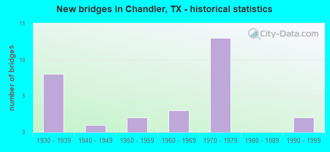
- New bridges - historical statistics
- 81930-1939
- 11940-1949
- 21950-1959
- 31960-1969
- 131970-1979
- 21990-1999

- Reconstructed bridges - Historical Statistics
- 21950-1959
- 11960-1969
- 51970-1979
- 01980-1989
- 01990-1999
- 32000-2009


- Bridge Condition - Deck
- 71.4%Good
- 23.8%Satisfactory
- 4.8%Fair

- Bridge Condition - Superstructure
- 4.8%Very good
- 42.9%Good
- 42.9%Satisfactory
- 4.8%Fair
- 4.8%Poor

- Bridge Condition - Substructure
- 38.1%Good
- 47.6%Satisfactory
- 14.3%Fair

- Bridge Condition - Channel
- 3.7%Very good
- 25.9%Good
- 66.7%Satisfactory
- 3.7%Fair

- Bridge Condition - Culverts
- 37.5%Good
- 62.5%Satisfactory
Find on map >> Show street view
Structure Number: 101080016403016, Location: 3.60 MI W OF SMITH C/L (Lat: 32.299872, Lng: -95.508106), Route carried "on" structure: State highway 31, Year Built: 1930, Year Reconstructed: 1975, Status: Open, Structure Length: 7.83m (25.69ft), Average Daily Traffic: 5,945 (year 2020), Truck Traffic: 9%, Average Future Daily Traffic: 7,960 (year 2033), Design Load: H 15, Features Intersected: KICKAPOO CR REL #2
Minimum Vertical Clearance: 30+ m (98+ ft), Kilometerpoint: 62.243, Lanes on structure: 2, Owner: State Highway Agency, Approaching Roadway Width: 12.8m (42.0ft), Material/Design: Concrete, Design/Construction: Tee Beam, Number Of Spans In Main Unit: 9, Length of Maximum Span: 8.8m (28.9ft), Curb-To-Curb Width: 12.7m (41.7ft), Out-to-Out Width: 13.5m (44.3ft)
Condition: Deck: Good, Superstructure: Satisfactory, Substructure: Satisfactory, Channel: Satisfactory, Operating Rating: 56.2 metric tons, Method Used To Determine Operating Rating: Load Factor (LF), Inventory Rating: 33.6 metric tons, Method Used To Determine Inventory Rating: Load Factor (LF), Structural Evaluation: Equal to present minimum criteria, Deck Geometry: Better than present minimum criteria, Waterway Adequacy: Equal to present minimum criteria, Approach Roadway Alignment: Equal to present desirable criteria, Designated Inspection Frequency: Every 24 months, Inspection Date: Febuary 2021, Deck Structure Type: Concrete Cast-file-Place, Wearing Surface/Protective System: Wearing Surface: Bituminous
Find on map >> Show street view
Structure Number: 101080016403017, Location: 3.50 MI W OF SMITH C/L (Lat: 32.300133, Lng: -95.506717), Route carried "on" structure: State highway 31, Year Built: 1930, Year Reconstructed: 1975, Status: Open, Structure Length: 10.42m (34.19ft), Average Daily Traffic: 5,945 (year 2020), Truck Traffic: 9%, Average Future Daily Traffic: 7,960 (year 2033), Design Load: H 15, Features Intersected: KICKAPOO CREEK
Minimum Vertical Clearance: 30+ m (98+ ft), Kilometerpoint: 62.377, Lanes on structure: 2, Owner: State Highway Agency, Approaching Roadway Width: 12.8m (42.0ft), Material/Design: Concrete, Design/Construction: Tee Beam, Number Of Spans In Main Unit: 12, Length of Maximum Span: 8.8m (28.9ft), Curb-To-Curb Width: 12.7m (41.7ft), Out-to-Out Width: 13.5m (44.3ft)
Condition: Deck: Satisfactory, Superstructure: Satisfactory, Substructure: Satisfactory, Channel: Satisfactory, Operating Rating: 56.2 metric tons, Method Used To Determine Operating Rating: Load Factor (LF), Inventory Rating: 33.6 metric tons, Method Used To Determine Inventory Rating: Load Factor (LF), Structural Evaluation: Equal to present minimum criteria, Deck Geometry: Better than present minimum criteria, Waterway Adequacy: Equal to present minimum criteria, Approach Roadway Alignment: Equal to present desirable criteria, Designated Inspection Frequency: Every 24 months, Inspection Date: Febuary 2021, Deck Structure Type: Concrete Cast-file-Place, Wearing Surface/Protective System: Wearing Surface: Bituminous
Find on map >> Show street view
Structure Number: 101080016403018, Location: 3.20 MI W OF SMITH C/L (Lat: 32.301125, Lng: -95.501381), Route carried "on" structure: State highway 31, Year Built: 1930, Year Reconstructed: 1955, Status: Open, Structure Length: 2.62m (8.60ft), Average Daily Traffic: 5,945 (year 2020), Truck Traffic: 9%, Average Future Daily Traffic: 7,960 (year 2033), Design Load: H 15, Features Intersected: KICKAPOO CREEK RELIEF #3
Minimum Vertical Clearance: 30+ m (98+ ft), Kilometerpoint: 62.890, Lanes on structure: 2, Owner: State Highway Agency, Approaching Roadway Width: 12.2m (40.0ft), Material/Design: Concrete, Design/Construction: Tee Beam, Number Of Spans In Main Unit: 3, Length of Maximum Span: 8.8m (28.9ft), Curb-To-Curb Width: 12.0m (39.4ft), Out-to-Out Width: 12.8m (42.0ft)
Condition: Deck: Satisfactory, Superstructure: Satisfactory, Substructure: Fair, Channel: Satisfactory, Operating Rating: 41.7 metric tons, Method Used To Determine Operating Rating: Load Factor (LF), Inventory Rating: 24.5 metric tons, Method Used To Determine Inventory Rating: Load Factor (LF), Structural Evaluation: Somewhat better than minimum adequacy, Deck Geometry: Better than present minimum criteria, Waterway Adequacy: Equal to present minimum criteria, Approach Roadway Alignment: Equal to present desirable criteria, Designated Inspection Frequency: Every 24 months, Inspection Date: Febuary 2021, Deck Structure Type: Concrete Cast-file-Place, Wearing Surface/Protective System: Wearing Surface: Bituminous
Find on map >> Show street view
Structure Number: 10108001640302, Location: 0.40 MI W OF SMITH C/L (Lat: 32.312928, Lng: -95.459219), Route carried "on" structure: State highway 31, Year Built: 1930, Year Reconstructed: 1975, Status: Open, Structure Length: 19.96m (65.49ft), Average Daily Traffic: 19,495 (year 2018), Truck Traffic: 18%, Average Future Daily Traffic: 25,220 (year 2033), Design Load: H 15, Features Intersected: NECHES RIVER RELIEF
Minimum Vertical Clearance: 30+ m (98+ ft), Kilometerpoint: 67.209, Lanes on structure: 5, Owner: State Highway Agency, Approaching Roadway Width: 26.8m (87.9ft), Material/Design: Concrete, Design/Construction: Tee Beam, Number Of Spans In Main Unit: 23, Length of Maximum Span: 8.8m (28.9ft), Curb-To-Curb Width: 26.8m (87.9ft), Out-to-Out Width: 27.5m (90.2ft)
Condition: Deck: Satisfactory, Superstructure: Satisfactory, Substructure: Fair, Channel: Satisfactory, Operating Rating: 60.8 metric tons, Method Used To Determine Operating Rating: Load Factor (LF), Inventory Rating: 36.3 metric tons, Method Used To Determine Inventory Rating: Load Factor (LF), Structural Evaluation: Somewhat better than minimum adequacy, Deck Geometry: Superior to present desirable criteria, Waterway Adequacy: Equal to present minimum criteria, Approach Roadway Alignment: Equal to present desirable criteria, Designated Inspection Frequency: Every 24 months, Inspection Date: Febuary 2021, Deck Structure Type: Concrete Cast-file-Place, Wearing Surface/Protective System: Wearing Surface: Bituminous
Find on map >> Show street view
Structure Number: 101080016403023, Location: 0.7 MI W OF FM 315 (Lat: 32.304814, Lng: -95.490914), Route carried "on" structure: State highway 31, Year Built: 1930, Year Reconstructed: 1955, Status: Open, Structure Length: 4.48m (14.70ft), Average Daily Traffic: 6,001 (year 2020), Truck Traffic: 9%, Average Future Daily Traffic: 7,960 (year 2033), Features Intersected: UP RR
Minimum Vertical Clearance: 30+ m (98+ ft), Kilometerpoint: 64.016, Lanes on structure: 2, Owner: State Highway Agency, Approaching Roadway Width: 12.2m (40.0ft), Skew: 4 degrees, Material/Design: Steel, Design/Construction: Stringer/Multi-beam, Number Of Spans In Main Unit: 3, Length of Maximum Span: 14.9m (48.9ft), Curb-To-Curb Width: 12.0m (39.4ft), Out-to-Out Width: 12.8m (42.0ft)
Condition: Deck: Satisfactory, Superstructure: Poor, Substructure: Satisfactory, Operating Rating: 45.4 metric tons, Method Used To Determine Operating Rating: Load Factor (LF), Inventory Rating: 27.2 metric tons, Method Used To Determine Inventory Rating: Load Factor (LF), Structural Evaluation: Meets minimum limits, Deck Geometry: Better than present minimum criteria, Underclear: Meets minimum limits, Approach Roadway Alignment: Equal to present desirable criteria, Length Of Structure Improvement: 4.48m (14.70ft), Designated Inspection Frequency: Every 24 months, Inspection Date: Febuary 2021, Bridge Improvement Cost: $315,000, Roadway Improvement Cost: $160,000, Total Project Cost: $475,000, Deck Structure Type: Concrete Cast-file-Place, Wearing Surface/Protective System: Wearing Surface: Bituminous
Find on map >> Show street view
Structure Number: 101080016403036, Location: 3.7 MI W OF FM 315 (Lat: 32.302328, Lng: -95.539508), Route carried "on" structure: State highway 31, Year Built: 1965, Year Reconstructed: 1984, Status: Open, Structure Length: 1.01m (3.31ft), Average Daily Traffic: 10,828 (year 2020), Truck Traffic: 9%, Average Future Daily Traffic: 15,930 (year 2033), Features Intersected: HORN BRANCH
Minimum Vertical Clearance: 30+ m (98+ ft), Kilometerpoint: 59.131, Lanes on structure: 5, Owner: State Highway Agency, Approaching Roadway Width: 25.6m (84.0ft), Skew: 1 degrees, Material/Design: Concrete, Design/Construction: Culvert, Number Of Spans In Main Unit: 3, Length of Maximum Span: 3.0m (9.8ft), Curb-To-Curb Width: 25.6m (84.0ft), Out-to-Out Width: 34.3m (112.5ft)
Condition: Channel: Satisfactory, Culverts: Good, Operating Rating: 39.9 metric tons, Method Used To Determine Operating Rating: Load Factor (LF), Inventory Rating: 23.6 metric tons, Method Used To Determine Inventory Rating: Load Factor (LF), Structural Evaluation: Somewhat better than minimum adequacy, Deck Geometry: Superior to present desirable criteria, Waterway Adequacy: Equal to present minimum criteria, Approach Roadway Alignment: Equal to present desirable criteria, Designated Inspection Frequency: Every 24 months, Inspection Date: Febuary 2021, Deck Structure Type: Concrete Cast-file-Place, Wearing Surface/Protective System: Wearing Surface: Bituminous
Find on map >> Show street view
Structure Number: 101080016403037, Location: 2.9 MI W OF FM 315 (Lat: 32.297258, Lng: -95.525389), Route carried "on" structure: State highway 31, Year Built: 1965, Year Reconstructed: 1972, Status: Open, Structure Length: 1.07m (3.51ft), Average Daily Traffic: 10,828 (year 2020), Truck Traffic: 9%, Average Future Daily Traffic: 15,930 (year 2033), Design Load: HS 20, Features Intersected: CANANT CREEK
Minimum Vertical Clearance: 30+ m (98+ ft), Kilometerpoint: 60.576, Lanes on structure: 5, Owner: State Highway Agency, Approaching Roadway Width: 25.6m (84.0ft), Material/Design: Concrete, Design/Construction: Culvert, Number Of Spans In Main Unit: 4, Length of Maximum Span: 2.4m (7.9ft), Out-to-Out Width: 52.8m (173.2ft)
Condition: Channel: Satisfactory, Culverts: Satisfactory, Operating Rating: 39.9 metric tons, Method Used To Determine Operating Rating: Load Factor (LF), Inventory Rating: 23.6 metric tons, Method Used To Determine Inventory Rating: Load Factor (LF), Structural Evaluation: Somewhat better than minimum adequacy, Waterway Adequacy: Equal to present minimum criteria, Approach Roadway Alignment: Equal to present desirable criteria, Designated Inspection Frequency: Every 24 months, Inspection Date: Febuary 2021
Find on map >> Show street view
Structure Number: 101080016403038, Location: 2.2 MI W OF FM 315 (Lat: 32.298778, Lng: -95.513972), Route carried "on" structure: State highway 31, Year Built: 1975, Status: Open, Structure Length: 2.77m (9.09ft), Average Daily Traffic: 5,945 (year 2020), Truck Traffic: 9%, Average Future Daily Traffic: 7,960 (year 2033), Design Load: HS 20, Features Intersected: KICKAPOO CREEK RELIEF #1
Minimum Vertical Clearance: 30+ m (98+ ft), Kilometerpoint: 61.676, Lanes on structure: 2, Owner: State Highway Agency, Approaching Roadway Width: 12.2m (40.0ft), Material/Design: Concrete, Design/Construction: Stringer/Multi-beam, Number Of Spans In Main Unit: 3, Length of Maximum Span: 9.1m (29.9ft), Curb-To-Curb Width: 12.5m (41.0ft), Out-to-Out Width: 13.5m (44.3ft)
Condition: Deck: Good, Superstructure: Good, Substructure: Good, Channel: Satisfactory, Operating Rating: 68.0 metric tons, Method Used To Determine Operating Rating: Load Factor (LF), Inventory Rating: 40.8 metric tons, Method Used To Determine Inventory Rating: Load Factor (LF), Structural Evaluation: Better than present minimum criteria, Deck Geometry: Better than present minimum criteria, Waterway Adequacy: Equal to present minimum criteria, Approach Roadway Alignment: Equal to present desirable criteria, Designated Inspection Frequency: Every 24 months, Inspection Date: Febuary 2021, Deck Structure Type: Concrete Cast-file-Place, Wearing Surface/Protective System: Wearing Surface: Bituminous
Find on map >> Show street view
Structure Number: 101080016403039, Location: 3.60 MI W OF SMITH C/L (Lat: 32.299411, Lng: -95.507942), Route carried "on" structure: State highway 31, Year Built: 1972, Status: Open, Structure Length: 7.41m (24.31ft), Average Daily Traffic: 6,001 (year 2020), Truck Traffic: 9%, Average Future Daily Traffic: 7,960 (year 2033), Design Load: HS 20, Features Intersected: KICKAPOO CREEK RELIEF #2
Minimum Vertical Clearance: 30+ m (98+ ft), Kilometerpoint: 62.246, Lanes on structure: 2, Owner: State Highway Agency, Approaching Roadway Width: 12.2m (40.0ft), Material/Design: Concrete, Design/Construction: Stringer/Multi-beam, Number Of Spans In Main Unit: 8, Length of Maximum Span: 9.1m (29.9ft), Curb-To-Curb Width: 12.5m (41.0ft), Out-to-Out Width: 13.5m (44.3ft)
Condition: Deck: Good, Superstructure: Good, Substructure: Satisfactory, Channel: Satisfactory, Operating Rating: 68.0 metric tons, Method Used To Determine Operating Rating: Load Factor (LF), Inventory Rating: 40.8 metric tons, Method Used To Determine Inventory Rating: Load Factor (LF), Structural Evaluation: Equal to present minimum criteria, Deck Geometry: Better than present minimum criteria, Waterway Adequacy: Equal to present minimum criteria, Approach Roadway Alignment: Equal to present desirable criteria, Designated Inspection Frequency: Every 24 months, Inspection Date: Febuary 2021, Deck Structure Type: Concrete Cast-file-Place, Wearing Surface/Protective System: Wearing Surface: Bituminous
Find on map >> Show street view
Structure Number: 10108001640304, Location: 3.50 MI W OF SMITH C/L (Lat: 32.299681, Lng: -95.506464), Route carried "on" structure: State highway 31, Year Built: 1972, Status: Open, Structure Length: 9.24m (30.31ft), Average Daily Traffic: 6,001 (year 2020), Truck Traffic: 9%, Average Future Daily Traffic: 7,960 (year 2033), Design Load: HS 20, Features Intersected: KICKAPOO CREEK
Minimum Vertical Clearance: 30+ m (98+ ft), Kilometerpoint: 62.389, Lanes on structure: 2, Owner: State Highway Agency, Approaching Roadway Width: 12.2m (40.0ft), Material/Design: Concrete, Design/Construction: Stringer/Multi-beam, Number Of Spans In Main Unit: 10, Length of Maximum Span: 9.1m (29.9ft), Curb-To-Curb Width: 12.7m (41.7ft), Out-to-Out Width: 13.5m (44.3ft)
Condition: Deck: Good, Superstructure: Good, Substructure: Satisfactory, Channel: Satisfactory, Operating Rating: 68.0 metric tons, Method Used To Determine Operating Rating: Load Factor (LF), Inventory Rating: 40.8 metric tons, Method Used To Determine Inventory Rating: Load Factor (LF), Structural Evaluation: Equal to present minimum criteria, Deck Geometry: Better than present minimum criteria, Waterway Adequacy: Equal to present minimum criteria, Approach Roadway Alignment: Equal to present desirable criteria, Designated Inspection Frequency: Every 24 months, Inspection Date: Febuary 2021, Deck Structure Type: Concrete Cast-file-Place, Wearing Surface/Protective System: Wearing Surface: Bituminous
Find on map >> Show street view
Structure Number: 101080016403041, Location: 3.20 MI W OF SMITH C/L (Lat: 32.300639, Lng: -95.501322), Route carried "on" structure: State highway 31, Year Built: 1972, Status: Open, Structure Length: 3.69m (12.11ft), Average Daily Traffic: 6,001 (year 2020), Truck Traffic: 9%, Average Future Daily Traffic: 7,960 (year 2033), Design Load: HS 20, Features Intersected: KICKAPOO CREEK RELIEF #3
Minimum Vertical Clearance: 30+ m (98+ ft), Kilometerpoint: 62.885, Lanes on structure: 2, Owner: State Highway Agency, Approaching Roadway Width: 12.2m (40.0ft), Material/Design: Concrete, Design/Construction: Stringer/Multi-beam, Number Of Spans In Main Unit: 4, Length of Maximum Span: 9.1m (29.9ft), Curb-To-Curb Width: 12.6m (41.3ft), Out-to-Out Width: 13.5m (44.3ft)
Condition: Deck: Good, Superstructure: Good, Substructure: Satisfactory, Channel: Satisfactory, Operating Rating: 68.0 metric tons, Method Used To Determine Operating Rating: Load Factor (LF), Inventory Rating: 40.8 metric tons, Method Used To Determine Inventory Rating: Load Factor (LF), Structural Evaluation: Equal to present minimum criteria, Deck Geometry: Better than present minimum criteria, Waterway Adequacy: Equal to present minimum criteria, Approach Roadway Alignment: Equal to present desirable criteria, Designated Inspection Frequency: Every 24 months, Inspection Date: Febuary 2021, Deck Structure Type: Concrete Cast-file-Place, Wearing Surface/Protective System: Wearing Surface: Bituminous
Find on map >> Show street view
Structure Number: 101080016403042, Location: 2.2 MI W OF FM 315 (Lat: 32.298300, Lng: -95.513847), Route carried "on" structure: State highway 31, Year Built: 1972, Status: Open, Structure Length: 2.77m (9.09ft), Average Daily Traffic: 6,001 (year 2020), Truck Traffic: 9%, Average Future Daily Traffic: 7,960 (year 2033), Design Load: HS 20, Features Intersected: KICKAPOO CREEK RELIEF #1
Minimum Vertical Clearance: 30+ m (98+ ft), Kilometerpoint: 61.676, Lanes on structure: 2, Owner: State Highway Agency, Approaching Roadway Width: 12.2m (40.0ft), Material/Design: Concrete, Design/Construction: Stringer/Multi-beam, Number Of Spans In Main Unit: 3, Length of Maximum Span: 9.1m (29.9ft), Curb-To-Curb Width: 12.6m (41.3ft), Out-to-Out Width: 13.5m (44.3ft)
Condition: Deck: Good, Superstructure: Good, Substructure: Good, Channel: Good, Operating Rating: 68.0 metric tons, Method Used To Determine Operating Rating: Load Factor (LF), Inventory Rating: 40.8 metric tons, Method Used To Determine Inventory Rating: Load Factor (LF), Structural Evaluation: Better than present minimum criteria, Deck Geometry: Better than present minimum criteria, Waterway Adequacy: Equal to present minimum criteria, Approach Roadway Alignment: Equal to present desirable criteria, Designated Inspection Frequency: Every 24 months, Inspection Date: Febuary 2021, Deck Structure Type: Concrete Cast-file-Place, Wearing Surface/Protective System: Wearing Surface: Bituminous
Find on map >> Show street view
Structure Number: 101080016403043, Location: 0.7 MI W OF FM 315 (Lat: 32.304736, Lng: -95.491236), Route carried "on" structure: State highway 31, Year Built: 1975, Status: Open, Structure Length: 5.33m (17.49ft), Average Daily Traffic: 5,945 (year 2020), Truck Traffic: 9%, Average Future Daily Traffic: 7,960 (year 2033), Design Load: HS 20, Features Intersected: UP RR
Minimum Vertical Clearance: 30+ m (98+ ft), Kilometerpoint: 64.012, Lanes on structure: 2, Owner: State Highway Agency, Approaching Roadway Width: 12.8m (42.0ft), Skew: 4 degrees, Material/Design: Prestressed concrete, Design/Construction: Stringer/Multi-beam, Number Of Spans In Main Unit: 3, Length of Maximum Span: 18.3m (60.0ft), Curb-To-Curb Width: 12.7m (41.7ft), Out-to-Out Width: 13.5m (44.3ft)
Condition: Deck: Good, Superstructure: Very good, Substructure: Good, Operating Rating: 54.4 metric tons, Method Used To Determine Operating Rating: Assigned rating based on Load Factor Design (LFD) reported in metric tons, Inventory Rating: 32.7 metric tons, Method Used To Determine Inventory Rating: Assigned rating based on Load Factor Design (LFD) reported in metric tons, Structural Evaluation: Better than present minimum criteria, Deck Geometry: Better than present minimum criteria, Underclear: Better than present minimum criteria, Approach Roadway Alignment: Equal to present desirable criteria, Designated Inspection Frequency: Every 24 months, Inspection Date: Febuary 2021, Deck Structure Type: Concrete Cast-file-Place, Wearing Surface/Protective System: Wearing Surface: Bituminous
Find on map >> Show street view
Structure Number: 101080016407013, Location: 3.9 MI E OF SH 31 (Lat: 32.296669, Lng: -95.539961), Route carried "on" structure: State highway 3204, Year Built: 1932, Status: Open, Structure Length: 1.74m (5.71ft), Average Daily Traffic: 495 (year 2020), Truck Traffic: 10%, Average Future Daily Traffic: 1,240 (year 2033), Design Load: H 15, Features Intersected: HORN BRANCH
Minimum Vertical Clearance: 30+ m (98+ ft), Kilometerpoint: 6.389, Lanes on structure: 2, Owner: State Highway Agency, Approaching Roadway Width: 6.7m (22.0ft), Material/Design: Concrete, Design/Construction: Tee Beam, Number Of Spans In Main Unit: 2, Length of Maximum Span: 8.8m (28.9ft), Curb-To-Curb Width: 7.3m (24.0ft), Out-to-Out Width: 8.2m (26.9ft)
Condition: Deck: Satisfactory, Superstructure: Satisfactory, Substructure: Satisfactory, Channel: Satisfactory, Operating Rating: 49.9 metric tons, Method Used To Determine Operating Rating: Load Factor (LF), Inventory Rating: 29.9 metric tons, Method Used To Determine Inventory Rating: Load Factor (LF), Structural Evaluation: Equal to present minimum criteria, Deck Geometry: Meets minimum limits, Waterway Adequacy: Better than present minimum criteria, Approach Roadway Alignment: Equal to present desirable criteria, Length Of Structure Improvement: 1.71m (5.61ft), Designated Inspection Frequency: Every 24 months, Inspection Date: Febuary 2021, Bridge Improvement Cost: $60,000, Roadway Improvement Cost: $20,000, Total Project Cost: $80,000, Deck Structure Type: Concrete Cast-file-Place, Wearing Surface/Protective System: Wearing Surface: Bituminous
Find on map >> Show street view
Structure Number: 101080016407014, Location: 4.8 MI E OF SH 31 (Lat: 32.296569, Lng: -95.525728), Route carried "on" structure: State highway 3204, Year Built: 1932, Status: Open, Structure Length: 0.79m (2.59ft), Average Daily Traffic: 495 (year 2020), Truck Traffic: 10%, Average Future Daily Traffic: 1,240 (year 2033), Features Intersected: CANANT CREEK
Minimum Vertical Clearance: 30+ m (98+ ft), Kilometerpoint: 7.741, Lanes on structure: 2, Owner: State Highway Agency, Approaching Roadway Width: 7.3m (24.0ft), Skew: 3 degrees, Material/Design: Concrete, Design/Construction: Culvert, Number Of Spans In Main Unit: 2, Length of Maximum Span: 3.0m (9.8ft), Curb-To-Curb Width: 7.3m (24.0ft), Out-to-Out Width: 11.7m (38.4ft)
Condition: Channel: Satisfactory, Culverts: Satisfactory, Operating Rating: 32.7 metric tons, Method Used To Determine Operating Rating: Field evaluation and documented engineering judgment, Inventory Rating: 24.5 metric tons, Method Used To Determine Inventory Rating: Field evaluation and documented engineering judgment, Structural Evaluation: Equal to present minimum criteria, Deck Geometry: Meets minimum limits, Waterway Adequacy: Better than present minimum criteria, Approach Roadway Alignment: Somewhat better than minimum adequacy, Length Of Structure Improvement: 0.73m (2.40ft), Designated Inspection Frequency: Every 24 months, Inspection Date: Febuary 2021, Bridge Improvement Cost: $1,000, Total Project Cost: $1,000, Deck Structure Type: Concrete Cast-file-Place, Wearing Surface/Protective System: Wearing Surface: Bituminous
Find on map >> Show street view
Structure Number: 101080055902005, Location: 1.80 MI N OF SH 31 (Lat: 32.332383, Lng: -95.474600), Route carried "on" structure: State highway 315, Year Built: 1948, Status: Open, Structure Length: 0.82m (2.69ft), Average Daily Traffic: 1,629 (year 2020), Truck Traffic: 10%, Average Future Daily Traffic: 2,290 (year 2033), Design Load: H 15, Features Intersected: MCFARLAND BRANCH
Minimum Vertical Clearance: 30+ m (98+ ft), Kilometerpoint: 2.527, Lanes on structure: 2, Owner: State Highway Agency, Approaching Roadway Width: 6.7m (22.0ft), Material/Design: Concrete, Design/Construction: Culvert, Number Of Spans In Main Unit: 4, Length of Maximum Span: 1.8m (5.9ft), Curb-To-Curb Width: 7.0m (23.0ft), Out-to-Out Width: 8.3m (27.2ft)
Condition: Channel: Satisfactory, Culverts: Satisfactory, Operating Rating: 32.7 metric tons, Method Used To Determine Operating Rating: Field evaluation and documented engineering judgment, Inventory Rating: 24.5 metric tons, Method Used To Determine Inventory Rating: Field evaluation and documented engineering judgment, Structural Evaluation: Equal to present minimum criteria, Deck Geometry: High priority of corrective action, Waterway Adequacy: Equal to present minimum criteria, Approach Roadway Alignment: Equal to present desirable criteria, Length Of Structure Improvement: 0.79m (2.59ft), Designated Inspection Frequency: Every 24 months, Inspection Date: Febuary 2021, Bridge Improvement Cost: $1,000, Total Project Cost: $1,000, Deck Structure Type: Concrete Cast-file-Place, Wearing Surface/Protective System: Wearing Surface: Bituminous
Find on map >> Show street view
Structure Number: 101080055902014, Location: 2.2 MI S OF SH 31 (Lat: 32.278642, Lng: -95.493667), Route carried "on" structure: State highway 315, Year Built: 1971, Status: Open, Structure Length: 7.32m (24.02ft), Average Daily Traffic: 6,888 (year 2020), Truck Traffic: 10%, Average Future Daily Traffic: 9,540 (year 2033), Design Load: HS 20, Features Intersected: KICKAPOO CREEK RELIEF #1
Minimum Vertical Clearance: 30+ m (98+ ft), Kilometerpoint: 8.919, Lanes on structure: 2, Owner: State Highway Agency, Approaching Roadway Width: 10.4m (34.1ft), Material/Design: Concrete, Design/Construction: Stringer/Multi-beam, Number Of Spans In Main Unit: 6, Length of Maximum Span: 12.2m (40.0ft), Curb-To-Curb Width: 10.4m (34.1ft), Out-to-Out Width: 11.0m (36.1ft)
Condition: Deck: Good, Superstructure: Satisfactory, Substructure: Good, Channel: Good, Operating Rating: 68.0 metric tons, Method Used To Determine Operating Rating: Load Factor (LF), Inventory Rating: 40.8 metric tons, Method Used To Determine Inventory Rating: Load Factor (LF), Structural Evaluation: Equal to present minimum criteria, Deck Geometry: Meets minimum limits, Waterway Adequacy: Superior to present desirable criteria, Approach Roadway Alignment: Equal to present desirable criteria, Designated Inspection Frequency: Every 24 months, Underwater Inspection Frequency: Every 60 months, Inspection Date: Febuary 2021, Underwater Inspection Date: May 2021, Deck Structure Type: Concrete Cast-file-Place
Find on map >> Show street view
Structure Number: 101080055902015, Location: 2.5 MI S OF SH 31 (Lat: 32.275200, Lng: -95.496397), Route carried "on" structure: State highway 315, Year Built: 1971, Status: Open, Structure Length: 9.75m (31.99ft), Average Daily Traffic: 6,888 (year 2020), Truck Traffic: 10%, Average Future Daily Traffic: 9,540 (year 2033), Design Load: HS 20, Features Intersected: KICKAPOO CREEK
Minimum Vertical Clearance: 30+ m (98+ ft), Kilometerpoint: 9.355, Lanes on structure: 2, Owner: State Highway Agency, Approaching Roadway Width: 10.4m (34.1ft), Material/Design: Concrete, Design/Construction: Stringer/Multi-beam, Number Of Spans In Main Unit: 8, Length of Maximum Span: 12.2m (40.0ft), Curb-To-Curb Width: 10.4m (34.1ft), Out-to-Out Width: 11.1m (36.4ft)
Condition: Deck: Good, Superstructure: Satisfactory, Substructure: Good, Channel: Good, Operating Rating: 68.0 metric tons, Method Used To Determine Operating Rating: Load Factor (LF), Inventory Rating: 40.8 metric tons, Method Used To Determine Inventory Rating: Load Factor (LF), Structural Evaluation: Equal to present minimum criteria, Deck Geometry: Meets minimum limits, Waterway Adequacy: Superior to present desirable criteria, Approach Roadway Alignment: Equal to present desirable criteria, Designated Inspection Frequency: Every 24 months, Underwater Inspection Frequency: Every 60 months, Inspection Date: Febuary 2021, Underwater Inspection Date: May 2021, Deck Structure Type: Concrete Cast-file-Place
Find on map >> Show street view
Structure Number: 101080055902016, Location: 2.7 MI S OF SH 31 (Lat: 32.272819, Lng: -95.498264), Route carried "on" structure: State highway 315, Year Built: 1971, Status: Open, Structure Length: 7.32m (24.02ft), Average Daily Traffic: 6,888 (year 2020), Truck Traffic: 10%, Average Future Daily Traffic: 9,540 (year 2033), Design Load: HS 20, Features Intersected: KICKAPOO CREEK RELIEF #2
Minimum Vertical Clearance: 30+ m (98+ ft), Kilometerpoint: 9.696, Lanes on structure: 2, Owner: State Highway Agency, Approaching Roadway Width: 10.4m (34.1ft), Material/Design: Concrete, Design/Construction: Stringer/Multi-beam, Number Of Spans In Main Unit: 6, Length of Maximum Span: 12.2m (40.0ft), Curb-To-Curb Width: 10.4m (34.1ft), Out-to-Out Width: 11.0m (36.1ft)
Condition: Deck: Good, Superstructure: Good, Substructure: Good, Channel: Good, Operating Rating: 68.0 metric tons, Method Used To Determine Operating Rating: Load Factor (LF), Inventory Rating: 40.8 metric tons, Method Used To Determine Inventory Rating: Load Factor (LF), Structural Evaluation: Better than present minimum criteria, Deck Geometry: Meets minimum limits, Waterway Adequacy: Superior to present desirable criteria, Approach Roadway Alignment: Equal to present desirable criteria, Designated Inspection Frequency: Every 24 months, Underwater Inspection Frequency: Every 60 months, Inspection Date: Febuary 2021, Underwater Inspection Date: May 2021, Deck Structure Type: Concrete Cast-file-Place
Find on map >> Show street view
Structure Number: 101080AA3310101, Location: 1.6 MI W OF FM 2010 (Lat: 32.348017, Lng: -95.522208), Route carried "on" structure: County highway 3310, Year Built: 1992, Year Reconstructed: 2012, Status: Open, Structure Length: 1.77m (5.81ft), Average Daily Traffic: 50 (year 2010), Average Future Daily Traffic: 50 (year 2030), Features Intersected: BATTLE CR
Minimum Vertical Clearance: 30+ m (98+ ft), Kilometerpoint: 2.575, Lanes on structure: 1, Owner: County Highway Agency, Approaching Roadway Width: 3.7m (12.1ft), Material/Design: Steel, Design/Construction: Stringer/Multi-beam, Number Of Spans In Main Unit: 2, Length of Maximum Span: 9.1m (29.9ft), Curb-To-Curb Width: 5.9m (19.4ft), Out-to-Out Width: 6.0m (19.7ft)
Condition: Deck: Good, Superstructure: Satisfactory, Substructure: Satisfactory, Channel: Satisfactory, Operating Rating: 49.0 metric tons, Method Used To Determine Operating Rating: Allowable Stress (AS), Inventory Rating: 34.5 metric tons, Method Used To Determine Inventory Rating: Allowable Stress (AS), Structural Evaluation: Equal to present minimum criteria, Deck Geometry: Meets minimum limits, Waterway Adequacy: Better than present minimum criteria, Approach Roadway Alignment: Equal to present minimum criteria, Length Of Structure Improvement: 1.74m (5.71ft), Designated Inspection Frequency: Every 24 months, Inspection Date: January 2020, Bridge Improvement Cost: $37,000, Roadway Improvement Cost: $3,000, Total Project Cost: $40,000, Deck Structure Type: Concrete Cast-file-Place
Find on map >> Show street view
Structure Number: 102120016404044, Location: AT HENDERSON CL (Lat: 32.315053, Lng: -95.452664), Route carried "on" structure: State highway 31, Year Built: 1975, Status: Open, Structure Length: 6.46m (21.19ft), Average Daily Traffic: 9,825 (year 2020), Truck Traffic: 18%, Average Future Daily Traffic: 12,610 (year 2033), Design Load: HS 20, Features Intersected: NECHES RIVER
Minimum Vertical Clearance: 30+ m (98+ ft), Kilometerpoint: 1.609, Lanes on structure: 2, Owner: State Highway Agency, Approaching Roadway Width: 12.2m (40.0ft), Material/Design: Concrete, Design/Construction: Stringer/Multi-beam, Number Of Spans In Main Unit: 7, Length of Maximum Span: 9.1m (29.9ft), Curb-To-Curb Width: 12.6m (41.3ft), Out-to-Out Width: 13.5m (44.3ft)
Condition: Deck: Good, Superstructure: Good, Substructure: Satisfactory, Channel: Good, Operating Rating: 68.0 metric tons, Method Used To Determine Operating Rating: Load Factor (LF), Inventory Rating: 40.8 metric tons, Method Used To Determine Inventory Rating: Load Factor (LF), Structural Evaluation: Equal to present minimum criteria, Deck Geometry: Better than present minimum criteria, Waterway Adequacy: Equal to present minimum criteria, Approach Roadway Alignment: Equal to present desirable criteria, Designated Inspection Frequency: Every 24 months, Underwater Inspection Frequency: Every 60 months, Inspection Date: March 2021, Underwater Inspection Date: November 2019, Deck Structure Type: Concrete Cast-file-Place
Find on map >> Show street view
Structure Number: 102120024505033, Location: 2.6 MI W OF FM 2661 (Lat: 32.374111, Lng: -95.474661), Route carried "on" structure: State highway 64, Year Built: 1953, Year Reconstructed: 1970, Status: Open, Structure Length: 15.24m (50.00ft), Average Daily Traffic: 5,351 (year 2020), Truck Traffic: 9%, Average Future Daily Traffic: 7,190 (year 2039), Features Intersected: NECHES RIVER
Minimum Vertical Clearance: 30+ m (98+ ft), Kilometerpoint: 0.000, Lanes on structure: 2, Owner: State Highway Agency, Approaching Roadway Width: 13.4m (44.0ft), Material/Design: Concrete continuous, Design/Construction: Slab, Number Of Spans In Main Unit: 20, Length of Maximum Span: 7.6m (24.9ft), Curb-To-Curb Width: 14.6m (47.9ft), Out-to-Out Width: 15.2m (49.9ft)
Condition: Deck: Good, Superstructure: Satisfactory, Substructure: Satisfactory, Channel: Satisfactory, Operating Rating: 44.4 metric tons, Method Used To Determine Operating Rating: Load Factor (LF), Inventory Rating: 27.2 metric tons, Method Used To Determine Inventory Rating: Load Factor (LF), Structural Evaluation: Equal to present minimum criteria, Deck Geometry: Superior to present desirable criteria, Waterway Adequacy: Equal to present minimum criteria, Approach Roadway Alignment: Equal to present desirable criteria, Designated Inspection Frequency: Every 24 months, Inspection Date: March 2021, Deck Structure Type: Concrete Cast-file-Place, Wearing Surface/Protective System: Wearing Surface: Bituminous
Find on map >> Show street view
Structure Number: 102120024509008, Location: AT VAN ZANDT CO LINE (Lat: 32.364311, Lng: -95.454511), Route carried "on" structure: State highway 279, Year Built: 1930, Status: Open, Structure Length: 19.11m (62.70ft), Average Daily Traffic: 2,091 (year 2020), Truck Traffic: 10%, Average Future Daily Traffic: 2,980 (year 2039), Features Intersected: NECHES RIVER
Minimum Vertical Clearance: 30+ m (98+ ft), Kilometerpoint: 0.000, Lanes on structure: 2, Owner: State Highway Agency, Approaching Roadway Width: 7.3m (24.0ft), Material/Design: Concrete, Design/Construction: Tee Beam, Number Of Spans In Main Unit: 22, Length of Maximum Span: 8.5m (27.9ft), Curb-To-Curb Width: 7.3m (24.0ft), Out-to-Out Width: 8.2m (26.9ft)
Condition: Deck: Fair, Superstructure: Fair, Substructure: Fair, Channel: Satisfactory, Operating Rating: 52.6 metric tons, Method Used To Determine Operating Rating: Load Factor (LF), Inventory Rating: 31.7 metric tons, Method Used To Determine Inventory Rating: Load Factor (LF), Structural Evaluation: Somewhat better than minimum adequacy, Deck Geometry: High priority of replacement, Waterway Adequacy: Equal to present minimum criteria, Approach Roadway Alignment: Equal to present desirable criteria, Length Of Structure Improvement: 19.11m (62.70ft), Designated Inspection Frequency: Every 24 months, Inspection Date: March 2021, Bridge Improvement Cost: $677,000, Roadway Improvement Cost: $80,000, Total Project Cost: $757,000, Deck Structure Type: Concrete Cast-file-Place, Wearing Surface/Protective System: Wearing Surface: Bituminous
Find on map >> Show street view
Structure Number: 102120265401001, Location: 1.0 MI S OF SH 31 (Lat: 32.306692, Lng: -95.439753), Route carried "on" structure: State highway 2661, Year Built: 1972, Status: Open, Structure Length: 2.77m (9.09ft), Average Daily Traffic: 3,697 (year 2020), Truck Traffic: 3%, Average Future Daily Traffic: 4,610 (year 2033), Design Load: HS 20, Features Intersected: INDIAN CREEK
Minimum Vertical Clearance: 30+ m (98+ ft), Kilometerpoint: 8.354, Lanes on structure: 2, Owner: State Highway Agency, Approaching Roadway Width: 8.5m (27.9ft), Material/Design: Concrete, Design/Construction: Stringer/Multi-beam, Number Of Spans In Main Unit: 3, Length of Maximum Span: 9.1m (29.9ft), Curb-To-Curb Width: 10.4m (34.1ft), Out-to-Out Width: 11.1m (36.4ft)
Condition: Deck: Good, Superstructure: Good, Substructure: Good, Channel: Good, Operating Rating: 68.0 metric tons, Method Used To Determine Operating Rating: Load Factor (LF), Inventory Rating: 40.8 metric tons, Method Used To Determine Inventory Rating: Load Factor (LF), Structural Evaluation: Better than present minimum criteria, Deck Geometry: Somewhat better than minimum adequacy, Waterway Adequacy: Equal to present minimum criteria, Approach Roadway Alignment: Equal to present desirable criteria, Designated Inspection Frequency: Every 24 months, Inspection Date: March 2021, Deck Structure Type: Concrete Cast-file-Place
Find on map >> Show street view
Structure Number: 102120265401002, Location: 3.0 MI S OF SH 31 (Lat: 32.280050, Lng: -95.443956), Route carried "on" structure: State highway 2661, Year Built: 1972, Status: Open, Structure Length: 1.37m (4.49ft), Average Daily Traffic: 3,170 (year 2018), Truck Traffic: 4%, Average Future Daily Traffic: 3,830 (year 2033), Design Load: HS 20, Features Intersected: BUTLER CREEK
Minimum Vertical Clearance: 30+ m (98+ ft), Kilometerpoint: 11.388, Lanes on structure: 2, Owner: State Highway Agency, Approaching Roadway Width: 8.5m (27.9ft), Skew: 3 degrees, Material/Design: Concrete, Design/Construction: Culvert, Number Of Spans In Main Unit: 4, Length of Maximum Span: 2.7m (8.9ft), Curb-To-Curb Width: 8.8m (28.9ft), Out-to-Out Width: 12.0m (39.4ft)
Condition: Channel: Satisfactory, Culverts: Good, Operating Rating: 39.9 metric tons, Method Used To Determine Operating Rating: Load Factor (LF), Inventory Rating: 23.6 metric tons, Method Used To Determine Inventory Rating: Load Factor (LF), Structural Evaluation: Equal to present minimum criteria, Deck Geometry: Meets minimum limits, Waterway Adequacy: Equal to present minimum criteria, Approach Roadway Alignment: Equal to present desirable criteria, Length Of Structure Improvement: 1.37m (4.49ft), Designated Inspection Frequency: Every 24 months, Inspection Date: March 2021, Bridge Improvement Cost: $2,000, Roadway Improvement Cost: $1,000, Total Project Cost: $3,000, Deck Structure Type: Concrete Cast-file-Place, Wearing Surface/Protective System: Wearing Surface: Bituminous
Find on map >> Show street view
Structure Number: 102120265401003, Location: 4.5 MI S OF SH 31 (Lat: 32.260603, Lng: -95.451339), Route carried "on" structure: State highway 2661, Year Built: 1972, Status: Open, Structure Length: 0.94m (3.08ft), Average Daily Traffic: 3,097 (year 2020), Truck Traffic: 3%, Average Future Daily Traffic: 4,030 (year 2033), Design Load: HS 20, Features Intersected: CANEY CREEK
Minimum Vertical Clearance: 30+ m (98+ ft), Kilometerpoint: 13.837, Lanes on structure: 2, Owner: State Highway Agency, Approaching Roadway Width: 8.5m (27.9ft), Material/Design: Concrete, Design/Construction: Culvert, Number Of Spans In Main Unit: 4, Length of Maximum Span: 2.1m (6.9ft), Curb-To-Curb Width: 8.7m (28.5ft), Out-to-Out Width: 12.6m (41.3ft)
Condition: Channel: Fair, Culverts: Satisfactory, Operating Rating: 39.9 metric tons, Method Used To Determine Operating Rating: Load Factor (LF), Inventory Rating: 23.6 metric tons, Method Used To Determine Inventory Rating: Load Factor (LF), Structural Evaluation: Equal to present minimum criteria, Deck Geometry: Meets minimum limits, Waterway Adequacy: Equal to present minimum criteria, Approach Roadway Alignment: Equal to present desirable criteria, Designated Inspection Frequency: Every 24 months, Inspection Date: March 2021, Bridge Improvement Cost: $30,000, Roadway Improvement Cost: $52,000, Total Project Cost: $82,000, Deck Structure Type: Concrete Cast-file-Place, Wearing Surface/Protective System: Wearing Surface: Bituminous
Find on map >> Show street view
Structure Number: 102120AA1131101, Location: 2.00 MI S OF FM 2661 (Lat: 32.277397, Lng: -95.434431), Route carried "on" structure: County highway 1131, Year Built: 1998, Status: Open, Structure Length: 1.16m (3.81ft), Average Daily Traffic: 70 (year 2009), Average Future Daily Traffic: 100 (year 2029), Features Intersected: BUTLER CREEK
Minimum Vertical Clearance: 30+ m (98+ ft), Kilometerpoint: 1.287, Lanes on structure: 2, Owner: County Highway Agency, Approaching Roadway Width: 5.5m (18.0ft), Material/Design: Steel, Design/Construction: Stringer/Multi-beam, Number Of Spans In Main Unit: 1, Length of Maximum Span: 11.0m (36.1ft), Curb-To-Curb Width: 8.0m (26.2ft), Out-to-Out Width: 8.5m (27.9ft)
Condition: Deck: Good, Superstructure: Good, Substructure: Good, Channel: Good, Operating Rating: 32.7 metric tons, Method Used To Determine Operating Rating: Field evaluation and documented engineering judgment, Inventory Rating: 24.5 metric tons, Method Used To Determine Inventory Rating: Field evaluation and documented engineering judgment, Structural Evaluation: Equal to present minimum criteria, Deck Geometry: Equal to present minimum criteria, Waterway Adequacy: Better than present minimum criteria, Approach Roadway Alignment: Better than present minimum criteria, Designated Inspection Frequency: Every 24 months, Inspection Date: October 2021, Deck Structure Type: Concrete Cast-file-Place
Find on map >> Show street view
Structure Number: 102340024504035, Location: 1.00 MI E OF FM 315 (Lat: 32.362914, Lng: -95.458967), Route carried "on" structure: State highway 279, Year Built: 1960, Year Reconstructed: 2006, Status: Open, Structure Length: 1.28m (4.20ft), Average Daily Traffic: 2,122 (year 2020), Truck Traffic: 10%, Average Future Daily Traffic: 2,980 (year 2033), Features Intersected: NECHES RV RL
Minimum Vertical Clearance: 30+ m (98+ ft), Kilometerpoint: 29.507, Lanes on structure: 2, Owner: State Highway Agency, Approaching Roadway Width: 8.2m (26.9ft), Material/Design: Concrete, Design/Construction: Culvert, Number Of Spans In Main Unit: 4, Length of Maximum Span: 3.0m (9.8ft), Curb-To-Curb Width: 8.2m (26.9ft), Out-to-Out Width: 17.0m (55.8ft)
Condition: Channel: Very good, Culverts: Satisfactory, Operating Rating: 32.7 metric tons, Method Used To Determine Operating Rating: Field evaluation and documented engineering judgment, Inventory Rating: 24.5 metric tons, Method Used To Determine Inventory Rating: Field evaluation and documented engineering judgment, Structural Evaluation: Equal to present minimum criteria, Deck Geometry: High priority of corrective action, Waterway Adequacy: Equal to present minimum criteria, Approach Roadway Alignment: Equal to present desirable criteria, Designated Inspection Frequency: Every 24 months, Inspection Date: October 2020, Deck Structure Type: Concrete Cast-file-Place, Wearing Surface/Protective System: Wearing Surface: Bituminous
Find on map >> Show street view
Structure Number: 102340024519032, Location: 6.25 MI E OF FM 314 (Lat: 32.376319, Lng: -95.494878), Route carried "on" structure: State highway 64, Year Built: 1953, Year Reconstructed: 2000, Status: Open, Structure Length: 0.67m (2.20ft), Average Daily Traffic: 5,297 (year 2020), Truck Traffic: 9%, Average Future Daily Traffic: 7,190 (year 2033), Features Intersected: NECHES RV TR
Minimum Vertical Clearance: 30+ m (98+ ft), Kilometerpoint: 61.347, Lanes on structure: 2, Owner: State Highway Agency, Approaching Roadway Width: 13.4m (44.0ft), Material/Design: Concrete, Design/Construction: Culvert, Number Of Spans In Main Unit: 3, Length of Maximum Span: 2.1m (6.9ft)
Condition: Channel: Satisfactory, Culverts: Good, Operating Rating: 32.7 metric tons, Method Used To Determine Operating Rating: Field evaluation and documented engineering judgment, Inventory Rating: 24.5 metric tons, Method Used To Determine Inventory Rating: Field evaluation and documented engineering judgment, Structural Evaluation: Equal to present minimum criteria, Waterway Adequacy: Equal to present minimum criteria, Approach Roadway Alignment: Equal to present desirable criteria, Designated Inspection Frequency: Every 24 months, Inspection Date: October 2020