Bridge Statistics for Chamberlain, South Dakota (SD)
Condition, Traffic, Stress, Structural Evaluation, Project Costs
- National Bridge Inventory (NBI) Statistics
- 15Number of bridges
- 581ft / 177mTotal length
- $24,296,000Total costs
- 52,266Total average daily traffic
- 7,714Total average daily truck traffic
- National Bridge Inventory (NBI) Registered Bridges for Chamberlain
- No street view available for this location
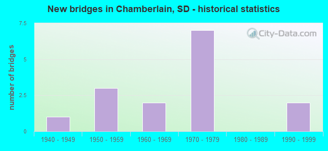
- New bridges - historical statistics
- 11940-1949
- 31950-1959
- 21960-1969
- 71970-1979
- 21990-1999

- Reconstructed bridges - Historical Statistics
- 11980-1989
- 01990-1999
- 02000-2009
- 12010-2019


- Bridge Condition - Deck
- 11.1%Very good
- 55.6%Good
- 33.3%Satisfactory

- Bridge Condition - Superstructure
- 22.2%Very good
- 11.1%Good
- 66.7%Satisfactory

- Bridge Condition - Substructure
- 55.6%Good
- 22.2%Satisfactory
- 11.1%Fair
- 11.1%Poor

- Bridge Condition - Channel
- 50.0%Very good
- 50.0%Good
Find on map >> Show street view
Structure Number: 8061094, Location: CHAMBERLAIN BRIDGE (Lat: 43.797053, Lng: -99.346517), Route carried "on" structure: Interstate 90, Year Built: 1974, Status: Open, Structure Length: 61.90m (203.08ft), Average Daily Traffic: 7,260 (year 2020), Truck Traffic: 23%, Average Future Daily Traffic: 8,894 (year 2040), Design Load: HS 20+Mod, Features Intersected: MO. RV (FRANCIS CASE LK)
Minimum Vertical Clearance: 30+ m (98+ ft), Kilometerpoint: 423.724, Lanes on structure: 4, Base Highway Network: Yes, Owner: State Highway Agency, Approaching Roadway Width: 23.2m (76.1ft), Skew: 30 degrees, Navigation Control: Yes ( Vertical Clearance: 10.0m (32.8ft), Horizontal Clearance: 74.0m (242.8ft)), Material/Design: Steel continuous, Design/Construction: Girder and Floorbeam System, Number Of Spans In Main Unit: 9, Length of Maximum Span: 76.2m (250.0ft), Curb-To-Curb Width: 23.2m (76.1ft), Out-to-Out Width: 24.4m (80.1ft)
Condition: Deck: Good, Superstructure: Satisfactory, Substructure: Fair, Channel: Good, Operating Rating: 35.9 metric tons, Method Used To Determine Operating Rating: Load Factor (LF), Inventory Rating: 21.2 metric tons, Method Used To Determine Inventory Rating: Load Factor (LF), Structural Evaluation: Somewhat better than minimum adequacy, Deck Geometry: Superior to present desirable criteria, Waterway Adequacy: Superior to present desirable criteria, Approach Roadway Alignment: Equal to present desirable criteria, Designated Inspection Frequency: Every 12 months, Critical Feature Inspection Frequency: Every 12 months, Underwater Inspection Frequency: Every 60 months, Inspection Date: May 2021, Critical Feature Inspection Date: May 2021, Underwater Inspection Date: September 2017, Deck Structure Type: Concrete Cast-file-Place, Wearing Surface/Protective System: Wearing Surface: Low Slump Concrete
Find on map >> Show street view
Structure Number: 8065095, Location: CHAMBERLAIN INTERCHANGE (Lat: 43.794761, Lng: -99.343006), Route carried "on" structure: Interstate 90, Year Built: 1974, Status: Open, Structure Length: 7.19m (23.59ft), Average Daily Traffic: 7,260 (year 2020), Truck Traffic: 23%, Average Future Daily Traffic: 8,894 (year 2040), Design Load: HS 20+Mod, Features Intersected: MAIN ST, SO DAK OWNED RR
Minimum Vertical Clearance: 30+ m (98+ ft), Kilometerpoint: 424.110, Lanes on structure: 5, Lanes under structure: 2, Base Highway Network: Yes, Owner: State Highway Agency, Approaching Roadway Width: 24.7m (81.0ft), Skew: 30 degrees, Material/Design: Steel continuous, Design/Construction: Stringer/Multi-beam, Number Of Spans In Main Unit: 4, Length of Maximum Span: 20.4m (66.9ft), Curb-To-Curb Width: 25.3m (83.0ft), Out-to-Out Width: 26.1m (85.6ft)
Condition: Deck: Good, Superstructure: Satisfactory, Substructure: Good, Operating Rating: 44.4 metric tons, Method Used To Determine Operating Rating: Load Factor (LF), Inventory Rating: 26.5 metric tons, Method Used To Determine Inventory Rating: Load Factor (LF), Structural Evaluation: Equal to present minimum criteria, Deck Geometry: Better than present minimum criteria, Underclear: Superior to present desirable criteria, Approach Roadway Alignment: Equal to present desirable criteria, Designated Inspection Frequency: Every 24 months, Inspection Date: January 2021, Deck Structure Type: Concrete Cast-file-Place, Wearing Surface/Protective System: Wearing Surface: Epoxy Overlay, Membrane: Epoxy
Find on map >> Show street view
Structure Number: 8066095, Location: CHAMBERLAIN INTERCH (Lat: 43.795356, Lng: -99.342186), Route carried "on" structure: Ramp Interstate 90, Year Built: 1974, Status: Open, Structure Length: 8.36m (27.43ft), Average Daily Traffic: 383 (year 2020), Truck Traffic: 10%, Average Future Daily Traffic: 441 (year 2040), Design Load: HS 20+Mod, Features Intersected: MAIN ST, SO DAK OWNED RR
Minimum Vertical Clearance: 30+ m (98+ ft), Kilometerpoint: 424.722, Lanes on structure: 1, Lanes under structure: 3, Base Highway Network: Yes, Owner: State Highway Agency, Approaching Roadway Width: 7.9m (25.9ft), Skew: 2 degrees, Material/Design: Steel continuous, Design/Construction: Stringer/Multi-beam, Number Of Spans In Main Unit: 4, Length of Maximum Span: 28.0m (91.9ft), Curb-To-Curb Width: 7.9m (25.9ft), Out-to-Out Width: 8.7m (28.5ft)
Condition: Deck: Satisfactory, Superstructure: Satisfactory, Substructure: Good, Operating Rating: 53.3 metric tons, Method Used To Determine Operating Rating: Load Factor (LF), Inventory Rating: 31.9 metric tons, Method Used To Determine Inventory Rating: Load Factor (LF), Structural Evaluation: Equal to present minimum criteria, Deck Geometry: Equal to present desirable criteria, Underclear: Superior to present desirable criteria, Approach Roadway Alignment: Equal to present minimum criteria, Designated Inspection Frequency: Every 24 months, Inspection Date: January 2021, Deck Structure Type: Concrete Cast-file-Place, Wearing Surface/Protective System: Wearing Surface: Epoxy Overlay, Membrane: Epoxy
Find on map >> Show street view
Structure Number: 8068084, Location: AT CHAMBERLAIN (Lat: 43.810511, Lng: -99.334419), Route carried "on" structure: Business Interstate 90, Year Built: 1953, Year Reconstructed: 2010, Status: Open, Structure Length: 61.07m (200.36ft), Average Daily Traffic: 1,652 (year 2020), Truck Traffic: 4%, Average Future Daily Traffic: 1,895 (year 2040), Design Load: HS 20+Mod, Features Intersected: MO. RV (FRANCIS CASE LK)
Minimum Vertical Clearance: 4.78m (15.68ft), Kilometerpoint: 424.642, Lanes on structure: 2, Base Highway Network: Yes, Owner: State Highway Agency, Approaching Roadway Width: 14.4m (47.2ft), Skew: 10 degrees, Navigation Control: Yes ( Vertical Clearance: 12.0m (39.4ft), Horizontal Clearance: 101.0m (331.4ft)), Material/Design: Steel, Design/Construction: Truss - Thru, Number Of Spans In Main Unit: 5, Number Of Approach Spans: 6, Length of Maximum Span: 103.0m (337.9ft), Curb or Sidewalk Widths: Left: 0.6m (2.0ft), Right: 0.6m (2.0ft), Curb-To-Curb Width: 11.0m (36.1ft), Out-to-Out Width: 15.2m (49.9ft)
Condition: Deck: Good, Superstructure: Good, Substructure: Satisfactory, Channel: Very good, Operating Rating: 53.4 metric tons, Method Used To Determine Operating Rating: Load Factor (LF), Inventory Rating: 32.0 metric tons, Method Used To Determine Inventory Rating: Load Factor (LF), Structural Evaluation: Equal to present minimum criteria, Deck Geometry: Equal to present minimum criteria, Waterway Adequacy: Equal to present desirable criteria, Approach Roadway Alignment: Somewhat better than minimum adequacy, Length Of Structure Improvement: 61.08m (200.39ft), Designated Inspection Frequency: Every 12 months, Critical Feature Inspection Frequency: Every 12 months, Underwater Inspection Frequency: Every 60 months, Inspection Date: May 2021, Critical Feature Inspection Date: May 2021, Underwater Inspection Date: September 2017, Bridge Improvement Cost: $22,000,000, Roadway Improvement Cost: $150,000, Total Project Cost: $23,000,000, Deck Structure Type: Concrete Cast-file-Place, Wearing Surface/Protective System: Wearing Surface: Monolithic Concrete, Deck Protection: Epoxy Coated Reinforcing
Find on map >> Show street view
Structure Number: 8069103, Location: 0.9 SE CHAMB INTERCHANGE (Lat: 43.784442, Lng: -99.333453), Route carried "on" structure: Ramp Interstate 90, Year Built: 1974, Status: Open, Structure Length: 8.66m (28.41ft), Average Daily Traffic: 4 (year 2020), Truck Traffic: 10%, Average Future Daily Traffic: 5 (year 2040), Design Load: HS 20+Mod, Features Intersected: I090
Minimum Vertical Clearance: 30+ m (98+ ft), Kilometerpoint: 425.494, Lanes on structure: 2, Lanes under structure: 5, Base Highway Network: Yes, Owner: State Highway Agency, Approaching Roadway Width: 14.6m (47.9ft), Skew: 30 degrees, Material/Design: Steel continuous, Design/Construction: Stringer/Multi-beam, Number Of Spans In Main Unit: 2, Number Of Approach Spans: 2, Length of Maximum Span: 31.1m (102.0ft), Curb-To-Curb Width: 14.6m (47.9ft), Out-to-Out Width: 15.4m (50.5ft)
Condition: Deck: Very good, Superstructure: Satisfactory, Substructure: Good, Operating Rating: 56.0 metric tons, Method Used To Determine Operating Rating: Load Factor (LF), Inventory Rating: 33.5 metric tons, Method Used To Determine Inventory Rating: Load Factor (LF), Structural Evaluation: Equal to present minimum criteria, Deck Geometry: Superior to present desirable criteria, Underclear: Somewhat better than minimum adequacy, Approach Roadway Alignment: Equal to present desirable criteria, Designated Inspection Frequency: Every 24 months, Inspection Date: January 2022, Deck Structure Type: Concrete Cast-file-Place, Wearing Surface/Protective System: Wearing Surface: Low Slump Concrete
Find on map >> Show street view
Structure Number: 8074081, Location: 0.5 N JCT I 90 LOOP (Lat: 43.815367, Lng: -99.327531), Route carried "on" structure: State highway 50, Year Built: 1999, Status: Open, Structure Length: 8.56m (28.08ft), Average Daily Traffic: 3,306 (year 2021), Truck Traffic: 4%, Average Future Daily Traffic: 4,288 (year 2041), Design Load: HS 25 or greater, Features Intersected: AMERICAN CK
Minimum Vertical Clearance: 30+ m (98+ ft), Kilometerpoint: 372.483, Lanes on structure: 2, Base Highway Network: Yes, Owner: State Highway Agency, Approaching Roadway Width: 14.6m (47.9ft), Material/Design: Prestressed concrete continuous, Design/Construction: Stringer/Multi-beam, Number Of Spans In Main Unit: 3, Length of Maximum Span: 29.3m (96.1ft), Curb or Sidewalk Widths: Left: 0.0m, Right: 2.4m (7.9ft), Curb-To-Curb Width: 15.2m (49.9ft), Out-to-Out Width: 19.4m (63.6ft)
Condition: Deck: Good, Superstructure: Very good, Substructure: Good, Channel: Very good, Operating Rating: 87.4 metric tons, Method Used To Determine Operating Rating: Load Factor (LF), Inventory Rating: 47.1 metric tons, Method Used To Determine Inventory Rating: Load Factor (LF), Structural Evaluation: Better than present minimum criteria, Deck Geometry: Superior to present desirable criteria, Waterway Adequacy: Superior to present desirable criteria, Approach Roadway Alignment: Equal to present desirable criteria, Designated Inspection Frequency: Every 24 months, Inspection Date: December 2021, Deck Structure Type: Concrete Cast-file-Place, Wearing Surface/Protective System: Wearing Surface: Monolithic Concrete, Deck Protection: Epoxy Coated Reinforcing
Find on map >> Show street view
Structure Number: 8074087, Location: 2.7 N I 90 INTERCH (Lat: 43.806622, Lng: -99.323328), Route carried "on" structure: State highway 50, Year Built: 1952, Status: Open, Structure Length: 6.47m (21.23ft), Average Daily Traffic: 4,707 (year 2021), Truck Traffic: 3%, Average Future Daily Traffic: 6,105 (year 2041), Design Load: H 20, Features Intersected: SOUTH DAKOTA OWNED RR
Minimum Vertical Clearance: 30+ m (98+ ft), Kilometerpoint: 374.076, Lanes on structure: 4, Base Highway Network: Yes, Owner: State Highway Agency, Approaching Roadway Width: 20.7m (67.9ft), Skew: 3 degrees, Material/Design: Concrete continuous, Design/Construction: Slab, Number Of Spans In Main Unit: 5, Length of Maximum Span: 13.0m (42.7ft), Curb or Sidewalk Widths: Left: 1.2m (3.9ft), Right: 1.2m (3.9ft), Curb-To-Curb Width: 14.6m (47.9ft), Out-to-Out Width: 17.8m (58.4ft)
Condition: Deck: Satisfactory, Superstructure: Satisfactory, Substructure: Poor, Operating Rating: 45.7 metric tons, Method Used To Determine Operating Rating: Load Factor (LF), Inventory Rating: 27.4 metric tons, Method Used To Determine Inventory Rating: Load Factor (LF), Structural Evaluation: Meets minimum limits, Deck Geometry: High priority of replacement, Underclear: Better than present minimum criteria, Approach Roadway Alignment: Better than present minimum criteria, Length Of Structure Improvement: 6.71m (22.01ft), Designated Inspection Frequency: Every 24 months, Inspection Date: June 2021, Bridge Improvement Cost: $990,000, Roadway Improvement Cost: $99,000, Total Project Cost: $1,296,000, Deck Structure Type: Concrete Cast-file-Place, Wearing Surface/Protective System: Wearing Surface: Bituminous
Find on map >> Show street view
Structure Number: 8080112, Location: E CHAMBERLAIN INTERCHANGE (Lat: 43.770578, Lng: -99.312361), Route carried "on" structure: State highway 50, Year Built: 1964, Year Reconstructed: 1993, Status: Open, Structure Length: 8.18m (26.84ft), Average Daily Traffic: 3,760 (year 2021), Truck Traffic: 4%, Average Future Daily Traffic: 4,877 (year 2041), Design Load: HS 20+Mod, Features Intersected: I090
Minimum Vertical Clearance: 30+ m (98+ ft), Kilometerpoint: 378.550, Lanes on structure: 2, Lanes under structure: 4, Base Highway Network: Yes, Owner: State Highway Agency, Approaching Roadway Width: 12.8m (42.0ft), Skew: 3 degrees, Material/Design: Prestressed concrete continuous, Design/Construction: Stringer/Multi-beam, Number Of Spans In Main Unit: 4, Length of Maximum Span: 23.5m (77.1ft), Curb-To-Curb Width: 12.2m (40.0ft), Out-to-Out Width: 13.0m (42.7ft)
Condition: Deck: Good, Superstructure: Very good, Substructure: Good, Operating Rating: 85.7 metric tons, Method Used To Determine Operating Rating: Load Factor (LF), Inventory Rating: 47.1 metric tons, Method Used To Determine Inventory Rating: Load Factor (LF), Structural Evaluation: Better than present minimum criteria, Deck Geometry: Equal to present minimum criteria, Underclear: Somewhat better than minimum adequacy, Approach Roadway Alignment: Better than present minimum criteria, Designated Inspection Frequency: Every 24 months, Inspection Date: May 2021, Deck Structure Type: Concrete Cast-file-Place, Wearing Surface/Protective System: Wearing Surface: Monolithic Concrete, Deck Protection: Epoxy Coated Reinforcing
Find on map >> Show street view
Structure Number: 8084042, Location: 5.4 N JCT I 90 LOOP (Lat: 43.872278, Lng: -99.298911), Route carried "on" structure: State highway 50, Year Built: 1995, Status: Open, Structure Length: 0.76m (2.49ft), Average Daily Traffic: 927 (year 2021), Truck Traffic: 11%, Average Future Daily Traffic: 1,202 (year 2041), Design Load: HS 20+Mod, Features Intersected: BAD HAND CK
Minimum Vertical Clearance: 30+ m (98+ ft), Kilometerpoint: 364.613, Lanes on structure: 2, Base Highway Network: Yes, Owner: State Highway Agency, Approaching Roadway Width: 11.0m (36.1ft), Material/Design: Concrete continuous, Design/Construction: Culvert, Number Of Spans In Main Unit: 2, Length of Maximum Span: 3.7m (12.1ft)
Condition: Channel: Good, Culverts: Good, Operating Rating: 89.8 metric tons, Method Used To Determine Operating Rating: Load Factor (LF), Inventory Rating: 87.7 metric tons, Method Used To Determine Inventory Rating: Load Factor (LF), Structural Evaluation: Better than present minimum criteria, Waterway Adequacy: Superior to present desirable criteria, Approach Roadway Alignment: Equal to present desirable criteria, Designated Inspection Frequency: Every 48 months, Inspection Date: July 2019
Find on map >> Show street view
Structure Number: 5016117, Location: 1.9 W I 29 INTERCH (Lat: 43.601958, Lng: -96.808528), Route carried "on" structure: State highway 38, Year Built: 1949, Status: Open, Structure Length: 0.95m (3.12ft), Average Daily Traffic: 4,902 (year 2021), Truck Traffic: 5%, Average Future Daily Traffic: 7,593 (year 2041), Design Load: H 15, Features Intersected: CK
Minimum Vertical Clearance: 30+ m (98+ ft), Kilometerpoint: 585.560, Lanes on structure: 2, Base Highway Network: Yes, Owner: State Highway Agency, Approaching Roadway Width: 11.0m (36.1ft), Material/Design: Concrete continuous, Design/Construction: Culvert, Number Of Spans In Main Unit: 3, Length of Maximum Span: 3.0m (9.8ft)
Condition: Channel: Very good, Culverts: Good, Operating Rating: 89.8 metric tons, Method Used To Determine Operating Rating: Load Factor (LF), Inventory Rating: 67.8 metric tons, Method Used To Determine Inventory Rating: Load Factor (LF), Structural Evaluation: Better than present minimum criteria, Waterway Adequacy: Equal to present desirable criteria, Approach Roadway Alignment: Equal to present desirable criteria, Designated Inspection Frequency: Every 48 months, Inspection Date: September 2020
Find on map >> Show street view
Structure Number: 5519536, Location: 1.4 E JCT SD 123 (Lat: 45.412956, Lng: -96.831917), Route carried "on" structure: State highway 15, Year Built: 1958, Status: Open, Structure Length: 4.62m (15.16ft), Average Daily Traffic: 885 (year 2021), Truck Traffic: 16%, Average Future Daily Traffic: 1,728 (year 2041), Design Load: H 20, Features Intersected: NORTH FORK WHETSTONE RV
Minimum Vertical Clearance: 30+ m (98+ ft), Kilometerpoint: 317.588, Lanes on structure: 2, Base Highway Network: Yes, Owner: State Highway Agency, Approaching Roadway Width: 11.0m (36.1ft), Material/Design: Concrete continuous, Design/Construction: Slab, Number Of Spans In Main Unit: 5, Length of Maximum Span: 9.4m (30.8ft), Curb-To-Curb Width: 9.1m (29.9ft), Out-to-Out Width: 10.5m (34.4ft)
Condition: Deck: Satisfactory, Superstructure: Satisfactory, Substructure: Satisfactory, Channel: Good, Operating Rating: 52.4 metric tons, Method Used To Determine Operating Rating: Load Factor (LF), Inventory Rating: 31.4 metric tons, Method Used To Determine Inventory Rating: Load Factor (LF), Structural Evaluation: Equal to present minimum criteria, Deck Geometry: Equal to present minimum criteria, Waterway Adequacy: Equal to present desirable criteria, Approach Roadway Alignment: Equal to present desirable criteria, Designated Inspection Frequency: Every 24 months, Inspection Date: August 2020, Deck Structure Type: Concrete Cast-file-Place, Wearing Surface/Protective System: Wearing Surface: Epoxy Overlay, Membrane: Epoxy
Find on map >> Show street view
Structure Number: 8065095, Location: CHAMBERLAIN INTERCHANGE (Lat: 43.794761, Lng: -99.343006), Route carried "under" structure: City street , Year Built: 1974, Structure Length: 0. m, Average Daily Traffic: 1,355 (year 2020), Truck Traffic: 1%, Features Intersected: MAIN ST, SO DAK OWNED RR, Facility Carried by Structure: I090
Minimum Vertical Clearance: 5.97m (19.59ft), Kilometerpoint: 0.000, Lanes on structure: 5, Lanes under structure: 2, Material/Design: Steel continuous, Design/Construction: Stringer/Multi-beam, Length of Maximum Span: 20.4m (66.9ft)
Find on map >> Show street view
Structure Number: 8066095, Location: CHAMBERLAIN INTERCH (Lat: 43.795356, Lng: -99.342186), Route carried "under" structure: City street , Year Built: 1974, Structure Length: 0. m, Average Daily Traffic: 1,355 (year 2020), Truck Traffic: 1%, Features Intersected: MAIN ST, SO DAK OWNED RR, Facility Carried by Structure: I090 WB OFF RAMP
Minimum Vertical Clearance: 5.49m (18.01ft), Kilometerpoint: 0.000, Lanes on structure: 1, Lanes under structure: 3, Material/Design: Steel continuous, Design/Construction: Stringer/Multi-beam, Length of Maximum Span: 28.0m (91.9ft)
Find on map >> Show street view
Structure Number: 8069103, Location: 0.9 SE CHAMB INTERCHANGE (Lat: 43.784442, Lng: -99.333453), Route carried "under" structure: Interstate 90, Year Built: 1974, Structure Length: 0. m, Average Daily Traffic: 7,250 (year 2020), Truck Traffic: 23%, Features Intersected: I090
Minimum Vertical Clearance: 5.11m (16.77ft), Kilometerpoint: 425.494, Lanes on structure: 2, Lanes under structure: 5, Material/Design: Steel continuous, Design/Construction: Stringer/Multi-beam, Length of Maximum Span: 31.1m (102.0ft)
Find on map >> Show street view
Structure Number: 8080112, Location: E CHAMBERLAIN INTERCHANGE (Lat: 43.770578, Lng: -99.312361), Route carried "under" structure: Interstate 90, Year Built: 1964, Structure Length: 0. m, Average Daily Traffic: 7,260 (year 2020), Truck Traffic: 23%, Features Intersected: I090, Facility Carried by Structure: SD050
Minimum Vertical Clearance: 4.95m (16.24ft), Kilometerpoint: 427.860, Lanes on structure: 2, Lanes under structure: 4, Material/Design: Prestressed concrete continuous, Design/Construction: Stringer/Multi-beam, Length of Maximum Span: 23.5m (77.1ft)