Bridge Statistics for Central City, Nebraska (NE)
Condition, Traffic, Stress, Structural Evaluation, Project Costs
- National Bridge Inventory (NBI) Statistics
- 30Number of bridges
- 213ft / 65.1mTotal length
- 20,825Total average daily traffic
- 2,512Total average daily truck traffic
- 27,782Total future (year 2033) average daily traffic
- National Bridge Inventory (NBI) Registered Bridges for Central City
- No street view available for this location
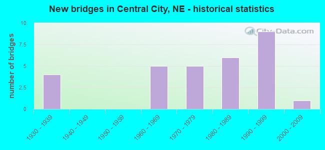
- New bridges - historical statistics
- 41930-1939
- 51960-1969
- 51970-1979
- 61980-1989
- 91990-1999
- 12000-2009


- Bridge Condition - Deck
- 20.0%Excellent
- 20.0%Very good
- 20.0%Good
- 20.0%Satisfactory
- 20.0%Fair

- Bridge Condition - Superstructure
- 20.0%Excellent
- 20.0%Very good
- 40.0%Good
- 20.0%Satisfactory

- Bridge Condition - Substructure
- 20.0%Excellent
- 20.0%Very good
- 20.0%Good
- 20.0%Satisfactory
- 20.0%Fair

- Bridge Condition - Channel
- 43.3%Excellent
- 26.7%Very good
- 23.3%Good
- 3.3%Satisfactory
- 3.3%Fair

- Bridge Condition - Culverts
- 56.0%Excellent
- 24.0%Very good
- 20.0%Good
Find on map >> Show street view
Structure Number: C006102503, Location: 2S 3W CENTRAL CITY (Lat: 41.089500, Lng: -98.058700), Route carried "on" structure: County highway 7617, Year Built: 1991, Status: Open, Structure Length: 1.34m (4.40ft), Average Daily Traffic: 50 (year 1998), Average Future Daily Traffic: 85 (year 2033), Features Intersected: WARM SLOUGH OVERFLOW, Facility Carried by Structure: 13TH RD
Minimum Vertical Clearance: 30+ m (98+ ft), Kilometerpoint: 0.077, Lanes on structure: 2, Owner: County Highway Agency, Approaching Roadway Width: 9.1m (29.9ft), Material/Design: Concrete, Design/Construction: Culvert, Number Of Spans In Main Unit: 4, Length of Maximum Span: 3.0m (9.8ft)
Condition: Channel: Excellent, Culverts: Excellent, Operating Rating: 33.0 metric tons, Method Used To Determine Operating Rating: Field evaluation and documented engineering judgment, Inventory Rating: 22.0 metric tons, Method Used To Determine Inventory Rating: Field evaluation and documented engineering judgment, Structural Evaluation: Equal to present minimum criteria, Waterway Adequacy: Superior to present desirable criteria, Approach Roadway Alignment: Equal to present desirable criteria, Designated Inspection Frequency: Every 24 months, Inspection Date: October 2021
Find on map >> Show street view
Structure Number: C00610251, Location: 2.5W 1N CENTRAL CITY (Lat: 41.135700, Lng: -98.058800), Route carried "on" structure: County highway 7617, Year Built: 1985, Status: Open, Structure Length: 1.40m (4.59ft), Average Daily Traffic: 90 (year 1998), Average Future Daily Traffic: 90 (year 2033), Design Load: HS 20, Features Intersected: SILVER CREEK
Minimum Vertical Clearance: 30+ m (98+ ft), Kilometerpoint: 0.591, Lanes on structure: 2, Owner: County Highway Agency, Approaching Roadway Width: 7.3m (24.0ft), Skew: 2 degrees, Material/Design: Concrete, Design/Construction: Culvert, Number Of Spans In Main Unit: 4, Length of Maximum Span: 3.0m (9.8ft)
Condition: Channel: Excellent, Culverts: Excellent, Operating Rating: 33.0 metric tons, Method Used To Determine Operating Rating: Field evaluation and documented engineering judgment, Inventory Rating: 22.0 metric tons, Method Used To Determine Inventory Rating: Field evaluation and documented engineering judgment, Structural Evaluation: Equal to present minimum criteria, Waterway Adequacy: Superior to present desirable criteria, Approach Roadway Alignment: Superior to present desirable criteria, Designated Inspection Frequency: Every 24 months, Inspection Date: October 2020
Find on map >> Show street view
Structure Number: C006102703, Location: JCT US30/N14 1.8S 2W (Lat: 41.090200, Lng: -98.039400), Route carried "on" structure: County highway 27, Year Built: 1991, Status: Open, Structure Length: 1.34m (4.40ft), Average Daily Traffic: 50 (year 2003), Average Future Daily Traffic: 70 (year 2033), Design Load: HS 20, Features Intersected: WARM SLOUGH OVERFLOW, Facility Carried by Structure: 14TH RD
Minimum Vertical Clearance: 30+ m (98+ ft), Kilometerpoint: 0.000, Lanes on structure: 2, Owner: County Highway Agency, Approaching Roadway Width: 9.1m (29.9ft), Material/Design: Concrete, Design/Construction: Culvert, Number Of Spans In Main Unit: 4, Length of Maximum Span: 3.0m (9.8ft)
Condition: Channel: Excellent, Culverts: Excellent, Operating Rating: 33.0 metric tons, Method Used To Determine Operating Rating: Field evaluation and documented engineering judgment, Inventory Rating: 22.0 metric tons, Method Used To Determine Inventory Rating: Field evaluation and documented engineering judgment, Structural Evaluation: Equal to present minimum criteria, Waterway Adequacy: Superior to present desirable criteria, Approach Roadway Alignment: Superior to present desirable criteria, Designated Inspection Frequency: Every 24 months, Inspection Date: October 2020
Find on map >> Show street view
Structure Number: C006102705, Location: 1.5W CENTRAL CITY (Lat: 41.106700, Lng: -98.038300), Route carried "on" structure: County highway 27, Year Built: 1999, Status: Open, Structure Length: 0.76m (2.49ft), Average Daily Traffic: 50 (year 2003), Average Future Daily Traffic: 85 (year 2033), Design Load: HS 20, Features Intersected: WARM SLOUGH, Facility Carried by Structure: COUNTY HIGHWAY
Minimum Vertical Clearance: 30+ m (98+ ft), Kilometerpoint: 0.000, Lanes on structure: 2, Owner: County Highway Agency, Approaching Roadway Width: 6.7m (22.0ft), Material/Design: Steel, Design/Construction: Culvert, Number Of Spans In Main Unit: 5, Length of Maximum Span: 1.5m (4.9ft)
Condition: Channel: Good, Culverts: Excellent, Operating Rating: 42.0 metric tons, Method Used To Determine Operating Rating: Field evaluation and documented engineering judgment, Inventory Rating: 33.0 metric tons, Method Used To Determine Inventory Rating: Field evaluation and documented engineering judgment, Structural Evaluation: Superior to present desirable criteria, Waterway Adequacy: Equal to present desirable criteria, Approach Roadway Alignment: Equal to present desirable criteria, Designated Inspection Frequency: Every 24 months, Inspection Date: October 2021
Find on map >> Show street view
Structure Number: C006102705P, Location: JCT US30/N14 1.8S 1.5W (Lat: 41.090300, Lng: -98.029500), Route carried "on" structure: County highway 27P, Year Built: 1992, Status: Open, Structure Length: 1.34m (4.40ft), Average Daily Traffic: 10 (year 2003), Average Future Daily Traffic: 14 (year 2033), Design Load: HS 20, Features Intersected: WARM SLOUGH OVERFLOW, Facility Carried by Structure: FIELD ENTRANCE
Minimum Vertical Clearance: 30+ m (98+ ft), Kilometerpoint: 0.000, Lanes on structure: 2, Owner: County Highway Agency, Approaching Roadway Width: 6.1m (20.0ft), Material/Design: Concrete, Design/Construction: Culvert, Number Of Spans In Main Unit: 4, Length of Maximum Span: 3.0m (9.8ft)
Condition: Channel: Excellent, Culverts: Excellent, Operating Rating: 33.0 metric tons, Method Used To Determine Operating Rating: Field evaluation and documented engineering judgment, Inventory Rating: 22.0 metric tons, Method Used To Determine Inventory Rating: Field evaluation and documented engineering judgment, Structural Evaluation: Equal to present minimum criteria, Waterway Adequacy: Superior to present desirable criteria, Approach Roadway Alignment: Superior to present desirable criteria, Designated Inspection Frequency: Every 24 months, Inspection Date: October 2020
Find on map >> Show street view
Structure Number: C006102903, Location: JCT US30/N14 1.8S 1W (Lat: 41.090500, Lng: -98.019800), Route carried "on" structure: County highway 29, Year Built: 1991, Status: Open, Structure Length: 1.34m (4.40ft), Average Daily Traffic: 205 (year 2003), Truck Traffic: 10%, Average Future Daily Traffic: 287 (year 2033), Design Load: HS 20, Features Intersected: WARM SLOUGH OVERFLOW, Facility Carried by Structure: 15TH RD
Minimum Vertical Clearance: 30+ m (98+ ft), Kilometerpoint: 0.000, Lanes on structure: 2, Owner: County Highway Agency, Approaching Roadway Width: 9.1m (29.9ft), Material/Design: Concrete, Design/Construction: Culvert, Number Of Spans In Main Unit: 4, Length of Maximum Span: 3.0m (9.8ft)
Condition: Channel: Excellent, Culverts: Excellent, Operating Rating: 33.0 metric tons, Method Used To Determine Operating Rating: Field evaluation and documented engineering judgment, Inventory Rating: 22.0 metric tons, Method Used To Determine Inventory Rating: Field evaluation and documented engineering judgment, Structural Evaluation: Equal to present minimum criteria, Waterway Adequacy: Superior to present desirable criteria, Approach Roadway Alignment: Superior to present desirable criteria, Designated Inspection Frequency: Every 24 months, Inspection Date: October 2020
Find on map >> Show street view
Structure Number: C006102905, Location: .5W CENTRAL CITY (Lat: 41.115300, Lng: -98.020000), Route carried "on" structure: County highway 7621, Year Built: 1999, Status: Open, Structure Length: 1.55m (5.09ft), Average Daily Traffic: 900 (year 1998), Average Future Daily Traffic: 1,530 (year 2033), Features Intersected: WARM SLOUGH
Minimum Vertical Clearance: 30+ m (98+ ft), Kilometerpoint: 0.117, Lanes on structure: 2, Owner: County Highway Agency, Approaching Roadway Width: 8.5m (27.9ft), Material/Design: Steel, Design/Construction: Culvert, Number Of Spans In Main Unit: 6, Length of Maximum Span: 1.8m (5.9ft)
Condition: Channel: Good, Culverts: Excellent, Operating Rating: 34.0 metric tons, Method Used To Determine Operating Rating: Field evaluation and documented engineering judgment, Inventory Rating: 33.0 metric tons, Method Used To Determine Inventory Rating: Field evaluation and documented engineering judgment, Structural Evaluation: Superior to present desirable criteria, Waterway Adequacy: Equal to present desirable criteria, Approach Roadway Alignment: Equal to present desirable criteria, Length Of Structure Improvement: 1.25m (4.10ft), Designated Inspection Frequency: Every 24 months, Inspection Date: November 2021
Find on map >> Show street view
Structure Number: C006102905P, Location: JCT US30/N14 1.8S .5W (Lat: 41.090500, Lng: -98.010200), Route carried "on" structure: County highway 29P, Year Built: 1992, Status: Open, Structure Length: 1.34m (4.40ft), Average Daily Traffic: 10 (year 2003), Average Future Daily Traffic: 14 (year 2033), Design Load: HS 20, Features Intersected: WARM SLOUGH OVERFLOW, Facility Carried by Structure: FIELD ENTRANCE
Minimum Vertical Clearance: 30+ m (98+ ft), Kilometerpoint: 0.000, Lanes on structure: 2, Owner: County Highway Agency, Approaching Roadway Width: 6.1m (20.0ft), Material/Design: Concrete, Design/Construction: Culvert, Number Of Spans In Main Unit: 4, Length of Maximum Span: 3.0m (9.8ft)
Condition: Channel: Excellent, Culverts: Excellent, Operating Rating: 33.0 metric tons, Method Used To Determine Operating Rating: Field evaluation and documented engineering judgment, Inventory Rating: 22.0 metric tons, Method Used To Determine Inventory Rating: Field evaluation and documented engineering judgment, Structural Evaluation: Equal to present minimum criteria, Waterway Adequacy: Superior to present desirable criteria, Approach Roadway Alignment: Superior to present desirable criteria, Designated Inspection Frequency: Every 24 months, Inspection Date: October 2021
Find on map >> Show street view
Structure Number: C006102907, Location: 1W 3N CENTRAL CITY (Lat: 41.163300, Lng: -98.020000), Route carried "on" structure: County highway 29, Year Built: 1984, Status: Open, Structure Length: 1.31m (4.30ft), Average Daily Traffic: 40 (year 2003), Average Future Daily Traffic: 68 (year 2033), Features Intersected: SILVER CREEK, Facility Carried by Structure: COUNTY HIGHWAY
Minimum Vertical Clearance: 30+ m (98+ ft), Kilometerpoint: 0.000, Lanes on structure: 2, Owner: County Highway Agency, Approaching Roadway Width: 9.1m (29.9ft), Material/Design: Concrete, Design/Construction: Culvert, Number Of Spans In Main Unit: 4, Length of Maximum Span: 3.0m (9.8ft)
Condition: Channel: Excellent, Culverts: Excellent, Operating Rating: 33.0 metric tons, Method Used To Determine Operating Rating: Field evaluation and documented engineering judgment, Inventory Rating: 22.0 metric tons, Method Used To Determine Inventory Rating: Field evaluation and documented engineering judgment, Structural Evaluation: Equal to present minimum criteria, Waterway Adequacy: Superior to present desirable criteria, Approach Roadway Alignment: Equal to present desirable criteria, Designated Inspection Frequency: Every 24 months, Inspection Date: October 2021
Find on map >> Show street view
Structure Number: C00610342, Location: 1.8W 3N CENTRAL CITY (Lat: 41.161700, Lng: -98.036700), Route carried "on" structure: County highway 34, Year Built: 1984, Status: Open, Structure Length: 1.46m (4.79ft), Average Daily Traffic: 150 (year 2003), Truck Traffic: 10%, Average Future Daily Traffic: 255 (year 2033), Features Intersected: SILVER CREEK, Facility Carried by Structure: COUNTY HIGHWAY
Minimum Vertical Clearance: 30+ m (98+ ft), Kilometerpoint: 0.000, Lanes on structure: 2, Owner: County Highway Agency, Approaching Roadway Width: 9.1m (29.9ft), Skew: 3 degrees, Material/Design: Concrete, Design/Construction: Culvert, Number Of Spans In Main Unit: 4, Length of Maximum Span: 3.0m (9.8ft)
Condition: Channel: Excellent, Culverts: Excellent, Operating Rating: 33.0 metric tons, Method Used To Determine Operating Rating: Field evaluation and documented engineering judgment, Inventory Rating: 22.0 metric tons, Method Used To Determine Inventory Rating: Field evaluation and documented engineering judgment, Structural Evaluation: Equal to present minimum criteria, Waterway Adequacy: Superior to present desirable criteria, Approach Roadway Alignment: Equal to present desirable criteria, Designated Inspection Frequency: Every 24 months, Inspection Date: October 2021
Find on map >> Show street view
Structure Number: C006103505, Location: 1.5E .2N CENTRAL CITY (Lat: 41.125000, Lng: -97.963300), Route carried "on" structure: County highway 35, Year Built: 1983, Status: Open, Structure Length: 1.19m (3.90ft), Average Daily Traffic: 45 (year 2003), Average Future Daily Traffic: 76 (year 2033), Features Intersected: WARM SLOUGH, Facility Carried by Structure: COUNTY HIGHWAY
Minimum Vertical Clearance: 30+ m (98+ ft), Kilometerpoint: 0.000, Lanes on structure: 2, Owner: County Highway Agency, Approaching Roadway Width: 9.1m (29.9ft), Material/Design: Concrete, Design/Construction: Culvert, Number Of Spans In Main Unit: 3, Length of Maximum Span: 3.7m (12.1ft)
Condition: Channel: Excellent, Culverts: Excellent, Operating Rating: 33.0 metric tons, Method Used To Determine Operating Rating: Field evaluation and documented engineering judgment, Inventory Rating: 22.0 metric tons, Method Used To Determine Inventory Rating: Field evaluation and documented engineering judgment, Structural Evaluation: Equal to present minimum criteria, Waterway Adequacy: Equal to present desirable criteria, Approach Roadway Alignment: Equal to present desirable criteria, Designated Inspection Frequency: Every 24 months, Inspection Date: November 2021
Find on map >> Show street view
Structure Number: C00610381, Location: 2.5W .7N CENTRAL CITY (Lat: 41.133300, Lng: -98.060000), Route carried "on" structure: County highway 38, Year Built: 1975, Status: Open, Structure Length: 1.01m (3.31ft), Average Daily Traffic: 55 (year 2003), Average Future Daily Traffic: 93 (year 2033), Design Load: H 15, Features Intersected: SILVER CREEK, Facility Carried by Structure: COUNTY HIGHWAY
Minimum Vertical Clearance: 30+ m (98+ ft), Kilometerpoint: 0.000, Lanes on structure: 2, Owner: County Highway Agency, Approaching Roadway Width: 7.3m (24.0ft), Material/Design: Steel, Design/Construction: Culvert, Number Of Spans In Main Unit: 7, Length of Maximum Span: 1.5m (4.9ft)
Condition: Channel: Fair, Culverts: Good, Operating Rating: 42.0 metric tons, Method Used To Determine Operating Rating: Field evaluation and documented engineering judgment, Inventory Rating: 33.0 metric tons, Method Used To Determine Inventory Rating: Field evaluation and documented engineering judgment, Structural Evaluation: Better than present minimum criteria, Waterway Adequacy: Better than present minimum criteria, Approach Roadway Alignment: Better than present minimum criteria, Designated Inspection Frequency: Every 24 months, Inspection Date: October 2021
Find on map >> Show street view
Structure Number: C006103815, Location: .7N 2.8E CENTRAL CITY (Lat: 41.133300, Lng: -97.940000), Route carried "on" structure: County highway 38, Year Built: 1989, Status: Open, Structure Length: 1.40m (4.59ft), Average Daily Traffic: 25 (year 2003), Average Future Daily Traffic: 42 (year 2033), Features Intersected: WARM SLOUGH, Facility Carried by Structure: COUNTY HIGHWAY
Minimum Vertical Clearance: 30+ m (98+ ft), Kilometerpoint: 0.000, Lanes on structure: 2, Owner: County Highway Agency, Approaching Roadway Width: 8.5m (27.9ft), Skew: 2 degrees, Material/Design: Concrete, Design/Construction: Culvert, Number Of Spans In Main Unit: 4, Length of Maximum Span: 3.0m (9.8ft)
Condition: Channel: Excellent, Culverts: Excellent, Operating Rating: 33.0 metric tons, Method Used To Determine Operating Rating: Field evaluation and documented engineering judgment, Inventory Rating: 22.0 metric tons, Method Used To Determine Inventory Rating: Field evaluation and documented engineering judgment, Structural Evaluation: Equal to present minimum criteria, Waterway Adequacy: Superior to present desirable criteria, Approach Roadway Alignment: Equal to present desirable criteria, Designated Inspection Frequency: Every 24 months, Inspection Date: November 2021
Find on map >> Show street view
Structure Number: C006103905P, Location: 3.7E 1.4N CENTRAL CITY (Lat: 41.144400, Lng: -97.919900), Route carried "on" structure: County highway P39, Year Built: 1968, Status: Posted for load, Structure Length: 1.22m (4.00ft), Average Daily Traffic: 25 (year 2003), Average Future Daily Traffic: 42 (year 2035), Design Load: HS 20, Features Intersected: WARM SLOUGH, Facility Carried by Structure: RD 20
Minimum Vertical Clearance: 30+ m (98+ ft), Kilometerpoint: 0.000, Lanes on structure: 2, Owner: County Highway Agency, Approaching Roadway Width: 7.3m (24.0ft), Material/Design: Wood or Timber, Design/Construction: Stringer/Multi-beam, Number Of Spans In Main Unit: 2, Length of Maximum Span: 5.8m (19.0ft), Curb or Sidewalk Widths: Left: 0.1m (0.3ft), Right: 0.1m (0.3ft), Curb-To-Curb Width: 6.6m (21.7ft), Out-to-Out Width: 6.7m (22.0ft)
Condition: Deck: Good, Superstructure: Good, Substructure: Good, Channel: Good, Operating Rating: 6.0 metric tons, Method Used To Determine Operating Rating: Allowable Stress (AS), Inventory Rating: 3.0 metric tons, Method Used To Determine Inventory Rating: Allowable Stress (AS), Structural Evaluation: High priority of replacement, Deck Geometry: Somewhat better than minimum adequacy, Waterway Adequacy: Meets minimum limits, Approach Roadway Alignment: Better than present minimum criteria, Bridge Posting: Required (Relationship of Operating Rating to Maximum Legal Load: > 39.9% below), Length Of Structure Improvement: 1.22m (4.00ft), Designated Inspection Frequency: Every 24 months, Inspection Date: August 2021, Deck Structure Type: Wood or Timber, Wearing Surface/Protective System: Wearing Surface: Bituminous
Find on map >> Show street view
Structure Number: C006104005P, Location: JCT US30/N14 2.8E .6S (Lat: 41.106900, Lng: -97.948400), Route carried "on" structure: County highway 2450, Year Built: 2002, Status: Open, Structure Length: 29.02m (95.21ft), Average Daily Traffic: 1,465 (year 2011), Average Future Daily Traffic: 1,611 (year 2033), Design Load: HS 20, Features Intersected: PLATTE RIVER
Minimum Vertical Clearance: 30+ m (98+ ft), Kilometerpoint: 0.467, Lanes on structure: 2, Owner: County Highway Agency, Approaching Roadway Width: 7.3m (24.0ft), Skew: 2 degrees, Material/Design: Prestressed concrete, Design/Construction: Stringer/Multi-beam, Number Of Spans In Main Unit: 10, Length of Maximum Span: 29.3m (96.1ft), Curb-To-Curb Width: 8.5m (27.9ft), Out-to-Out Width: 9.2m (30.2ft)
Condition: Deck: Excellent, Superstructure: Excellent, Substructure: Excellent, Channel: Excellent, Operating Rating: 62.0 metric tons, Method Used To Determine Operating Rating: Load Factor (LF), Inventory Rating: 37.0 metric tons, Method Used To Determine Inventory Rating: Load Factor (LF), Structural Evaluation: Superior to present desirable criteria, Deck Geometry: Somewhat better than minimum adequacy, Waterway Adequacy: Superior to present desirable criteria, Approach Roadway Alignment: Superior to present desirable criteria, Designated Inspection Frequency: Every 24 months, Inspection Date: November 2020, Deck Structure Type: Concrete Cast-file-Place, Wearing Surface/Protective System: Wearing Surface: Monolithic Concrete, Deck Protection: Epoxy Coated Reinforcing
Find on map >> Show street view
Structure Number: C00610401, Location: WJCT N14/N92 3.4W (Lat: 41.118800, Lng: -98.066800), Route carried "on" structure: County highway 2200, Year Built: 1935, Status: Open, Structure Length: 1.01m (3.31ft), Average Daily Traffic: 405 (year 2011), Average Future Daily Traffic: 490 (year 2033), Features Intersected: SILVER CREEK
Minimum Vertical Clearance: 30+ m (98+ ft), Kilometerpoint: 2.718, Lanes on structure: 2, Owner: County Highway Agency, Approaching Roadway Width: 6.7m (22.0ft), Material/Design: Concrete, Design/Construction: Culvert, Number Of Spans In Main Unit: 3, Length of Maximum Span: 3.0m (9.8ft)
Condition: Channel: Good, Culverts: Very good, Operating Rating: 33.0 metric tons, Method Used To Determine Operating Rating: Field evaluation and documented engineering judgment, Inventory Rating: 22.0 metric tons, Method Used To Determine Inventory Rating: Field evaluation and documented engineering judgment, Structural Evaluation: Equal to present minimum criteria, Waterway Adequacy: Equal to present minimum criteria, Approach Roadway Alignment: Equal to present desirable criteria, Designated Inspection Frequency: Every 24 months, Inspection Date: October 2020
Find on map >> Show street view
Structure Number: C006104015, Location: JCT US30/N14 .2N .5W (Lat: 41.119300, Lng: -98.011300), Route carried "on" structure: County highway 2200, Year Built: 1970, Status: Open, Structure Length: 1.22m (4.00ft), Average Daily Traffic: 730 (year 2011), Average Future Daily Traffic: 730 (year 2033), Features Intersected: WARM SLOUGH
Minimum Vertical Clearance: 30+ m (98+ ft), Kilometerpoint: 3.185, Lanes on structure: 2, Owner: County Highway Agency, Approaching Roadway Width: 9.8m (32.2ft), Material/Design: Concrete, Design/Construction: Culvert, Number Of Spans In Main Unit: 3, Length of Maximum Span: 3.7m (12.1ft)
Condition: Channel: Good, Culverts: Very good, Operating Rating: 33.0 metric tons, Method Used To Determine Operating Rating: Field evaluation and documented engineering judgment, Inventory Rating: 22.0 metric tons, Method Used To Determine Inventory Rating: Field evaluation and documented engineering judgment, Structural Evaluation: Somewhat better than minimum adequacy, Waterway Adequacy: Equal to present minimum criteria, Approach Roadway Alignment: Equal to present desirable criteria, Designated Inspection Frequency: Every 24 months, Inspection Date: November 2021
Find on map >> Show street view
Structure Number: C006104215, Location: 1.5W CENTRAL CITY (Lat: 41.105000, Lng: -98.040000), Route carried "on" structure: County highway 42, Year Built: 1971, Status: Open, Structure Length: 1.22m (4.00ft), Average Daily Traffic: 75 (year 2003), Average Future Daily Traffic: 127 (year 2033), Features Intersected: WARM SLOUGH, Facility Carried by Structure: COUNTY HIGHWAY
Minimum Vertical Clearance: 30+ m (98+ ft), Kilometerpoint: 0.000, Lanes on structure: 2, Owner: County Highway Agency, Approaching Roadway Width: 7.3m (24.0ft), Material/Design: Prestressed concrete, Design/Construction: Tee Beam, Number Of Spans In Main Unit: 1, Length of Maximum Span: 11.6m (38.1ft), Curb-To-Curb Width: 7.3m (24.0ft), Out-to-Out Width: 7.4m (24.3ft)
Condition: Deck: Very good, Superstructure: Very good, Substructure: Very good, Channel: Very good, Operating Rating: 33.0 metric tons, Method Used To Determine Operating Rating: Load Factor (LF), Inventory Rating: 24.0 metric tons, Method Used To Determine Inventory Rating: Load Factor (LF), Structural Evaluation: Equal to present minimum criteria, Deck Geometry: Equal to present minimum criteria, Waterway Adequacy: Equal to present desirable criteria, Approach Roadway Alignment: Better than present minimum criteria, Length Of Structure Improvement: 1.22m (4.00ft), Designated Inspection Frequency: Every 24 months, Inspection Date: April 2020, Deck Structure Type: Concrete Cast-file-Place, Wearing Surface/Protective System: Wearing Surface: Monolithic Concrete
Find on map >> Show street view
Structure Number: C006104415, Location: 3W 1S CENTRAL CITY (Lat: 41.089600, Lng: -98.067200), Route carried "on" structure: County highway 44, Year Built: 1932, Status: Posted for load, Structure Length: 1.46m (4.79ft), Average Daily Traffic: 50 (year 2003), Average Future Daily Traffic: 85 (year 2033), Features Intersected: WARM SLOUGH, Facility Carried by Structure: COUNTY HIGHWAY
Minimum Vertical Clearance: 30+ m (98+ ft), Kilometerpoint: 0.000, Lanes on structure: 2, Owner: County Highway Agency, Approaching Roadway Width: 7.3m (24.0ft), Material/Design: Steel, Design/Construction: Stringer/Multi-beam, Number Of Spans In Main Unit: 2, Length of Maximum Span: 7.0m (23.0ft), Curb-To-Curb Width: 5.8m (19.0ft), Out-to-Out Width: 6.1m (20.0ft)
Condition: Deck: Fair, Superstructure: Good, Substructure: Fair, Channel: Good, Operating Rating: 15.0 metric tons, Method Used To Determine Operating Rating: Load Factor (LF), Inventory Rating: 9.0 metric tons, Method Used To Determine Inventory Rating: Load Factor (LF), Structural Evaluation: High priority of corrective action, Deck Geometry: Meets minimum limits, Waterway Adequacy: Somewhat better than minimum adequacy, Approach Roadway Alignment: Better than present minimum criteria, Bridge Posting: Required (Relationship of Operating Rating to Maximum Legal Load: > 39.9% below), Length Of Structure Improvement: 1.46m (4.79ft), Designated Inspection Frequency: Every 24 months, Inspection Date: October 2021, Deck Structure Type: Other, Wearing Surface/Protective System: Wearing Surface: Monolithic Concrete
Find on map >> Show street view
Structure Number: C006112305, Location: 3.5W 1S CENTRAL CITY (Lat: 41.090000, Lng: -98.078300), Route carried "on" structure: County highway 123, Year Built: 1993, Status: Open, Structure Length: 1.52m (4.99ft), Average Daily Traffic: 40 (year 2003), Average Future Daily Traffic: 68 (year 2033), Features Intersected: WARM SLOUGH, Facility Carried by Structure: COUNTY HIGHWAY
Minimum Vertical Clearance: 30+ m (98+ ft), Kilometerpoint: 0.000, Lanes on structure: 2, Owner: County Highway Agency, Approaching Roadway Width: 8.5m (27.9ft), Material/Design: Concrete, Design/Construction: Culvert, Number Of Spans In Main Unit: 4, Length of Maximum Span: 3.7m (12.1ft)
Condition: Channel: Excellent, Culverts: Excellent, Operating Rating: 33.0 metric tons, Method Used To Determine Operating Rating: Field evaluation and documented engineering judgment, Inventory Rating: 22.0 metric tons, Method Used To Determine Inventory Rating: Field evaluation and documented engineering judgment, Structural Evaluation: Equal to present minimum criteria, Waterway Adequacy: Superior to present desirable criteria, Approach Roadway Alignment: Equal to present desirable criteria, Designated Inspection Frequency: Every 24 months, Inspection Date: October 2021
Find on map >> Show street view
Structure Number: C006113305, Location: .5E 3.7N CENTRAL CITY (Lat: 41.176700, Lng: -97.981700), Route carried "on" structure: County highway 133, Year Built: 1987, Status: Open, Structure Length: 1.31m (4.30ft), Average Daily Traffic: 20 (year 2003), Average Future Daily Traffic: 34 (year 2033), Features Intersected: SILVER CREEK, Facility Carried by Structure: COUNTY HIGHWAY
Minimum Vertical Clearance: 30+ m (98+ ft), Kilometerpoint: 0.000, Lanes on structure: 2, Owner: County Highway Agency, Approaching Roadway Width: 9.1m (29.9ft), Material/Design: Concrete, Design/Construction: Culvert, Number Of Spans In Main Unit: 4, Length of Maximum Span: 3.0m (9.8ft)
Condition: Channel: Excellent, Culverts: Excellent, Operating Rating: 33.0 metric tons, Method Used To Determine Operating Rating: Field evaluation and documented engineering judgment, Inventory Rating: 22.0 metric tons, Method Used To Determine Inventory Rating: Field evaluation and documented engineering judgment, Structural Evaluation: Equal to present minimum criteria, Waterway Adequacy: Superior to present desirable criteria, Approach Roadway Alignment: Equal to present desirable criteria, Designated Inspection Frequency: Every 24 months, Inspection Date: November 2021
Find on map >> Show street view
Structure Number: C006133805P, Location: NE EDGE OF CENTRAL CITY (Lat: 41.123300, Lng: -97.990000), Route carried "on" structure: County highway P338, Year Built: 1935, Status: Open, Structure Length: 0.91m (2.99ft), Average Daily Traffic: 200 (year 2003), Truck Traffic: 10%, Average Future Daily Traffic: 280 (year 2033), Features Intersected: WARM SLOUGH, Facility Carried by Structure: COUNTY HIGHWAY
Minimum Vertical Clearance: 30+ m (98+ ft), Kilometerpoint: 0.000, Lanes on structure: 2, Owner: County Highway Agency, Approaching Roadway Width: 7.3m (24.0ft), Material/Design: Steel, Design/Construction: Stringer/Multi-beam, Number Of Spans In Main Unit: 1, Length of Maximum Span: 8.5m (27.9ft), Curb-To-Curb Width: 5.8m (19.0ft), Out-to-Out Width: 6.1m (20.0ft)
Condition: Deck: Satisfactory, Superstructure: Satisfactory, Substructure: Satisfactory, Channel: Satisfactory, Operating Rating: 49.0 metric tons, Method Used To Determine Operating Rating: Load Factor (LF), Inventory Rating: 29.0 metric tons, Method Used To Determine Inventory Rating: Load Factor (LF), Structural Evaluation: Equal to present minimum criteria, Deck Geometry: High priority of corrective action, Waterway Adequacy: Somewhat better than minimum adequacy, Approach Roadway Alignment: Better than present minimum criteria, Length Of Structure Improvement: 0.91m (2.99ft), Designated Inspection Frequency: Every 24 months, Inspection Date: October 2020, Deck Structure Type: Concrete Cast-file-Place, Wearing Surface/Protective System: Wearing Surface: Monolithic Concrete
Find on map >> Show street view
Structure Number: M0465D3805, Location: CENTRAL CITY 11TH @ N14 (Lat: 41.121700, Lng: -98.003300), Route carried "on" structure: City street D38, Year Built: 1961, Status: Open, Structure Length: 1.13m (3.71ft), Average Daily Traffic: 200 (year 2003), Truck Traffic: 10%, Average Future Daily Traffic: 280 (year 2033), Features Intersected: WARM SLOUGH, Facility Carried by Structure: 11TH STREET
Minimum Vertical Clearance: 30+ m (98+ ft), Kilometerpoint: 0.000, Lanes on structure: 2, Owner: City or Municipal Highway Agency, Approaching Roadway Width: 7.6m (24.9ft), Material/Design: Concrete, Design/Construction: Culvert, Number Of Spans In Main Unit: 3, Length of Maximum Span: 3.7m (12.1ft)
Condition: Channel: Very good, Culverts: Very good, Operating Rating: 33.0 metric tons, Method Used To Determine Operating Rating: Field evaluation and documented engineering judgment, Inventory Rating: 22.0 metric tons, Method Used To Determine Inventory Rating: Field evaluation and documented engineering judgment, Structural Evaluation: Equal to present minimum criteria, Waterway Adequacy: Equal to present desirable criteria, Approach Roadway Alignment: Equal to present desirable criteria, Designated Inspection Frequency: Every 24 months, Inspection Date: October 2020
Find on map >> Show street view
Structure Number: M0465I2905, Location: CENTRAL CITY 21ST @ 11TH (Lat: 41.121700, Lng: -98.006700), Route carried "on" structure: City street I29, Year Built: 1961, Status: Open, Structure Length: 1.13m (3.71ft), Average Daily Traffic: 100 (year 2003), Truck Traffic: 10%, Average Future Daily Traffic: 140 (year 2033), Features Intersected: WARM SLOUGH, Facility Carried by Structure: 21ST AVENUE
Minimum Vertical Clearance: 30+ m (98+ ft), Kilometerpoint: 0.000, Lanes on structure: 2, Owner: City or Municipal Highway Agency, Approaching Roadway Width: 6.7m (22.0ft), Material/Design: Concrete, Design/Construction: Culvert, Number Of Spans In Main Unit: 3, Length of Maximum Span: 3.7m (12.1ft), Curb or Sidewalk Widths: Left: 0.0m, Right: 1.2m (3.9ft)
Condition: Channel: Very good, Culverts: Very good, Operating Rating: 33.0 metric tons, Method Used To Determine Operating Rating: Field evaluation and documented engineering judgment, Inventory Rating: 22.0 metric tons, Method Used To Determine Inventory Rating: Field evaluation and documented engineering judgment, Structural Evaluation: Equal to present minimum criteria, Waterway Adequacy: Equal to present desirable criteria, Approach Roadway Alignment: Equal to present desirable criteria, Designated Inspection Frequency: Every 24 months, Inspection Date: October 2020
Find on map >> Show street view
Structure Number: M0465J2905, Location: CENTRAL CITY 20TH @ 11TH (Lat: 41.121700, Lng: -98.005000), Route carried "on" structure: City street J29, Year Built: 1961, Status: Open, Structure Length: 1.13m (3.71ft), Average Daily Traffic: 150 (year 2003), Truck Traffic: 10%, Average Future Daily Traffic: 210 (year 2033), Features Intersected: WARM SLOUGH, Facility Carried by Structure: 20TH AVENUE
Minimum Vertical Clearance: 30+ m (98+ ft), Kilometerpoint: 0.000, Lanes on structure: 2, Owner: City or Municipal Highway Agency, Approaching Roadway Width: 7.3m (24.0ft), Material/Design: Concrete, Design/Construction: Culvert, Number Of Spans In Main Unit: 3, Length of Maximum Span: 3.7m (12.1ft)
Condition: Channel: Very good, Culverts: Very good, Operating Rating: 33.0 metric tons, Method Used To Determine Operating Rating: Field evaluation and documented engineering judgment, Inventory Rating: 22.0 metric tons, Method Used To Determine Inventory Rating: Field evaluation and documented engineering judgment, Structural Evaluation: Equal to present minimum criteria, Waterway Adequacy: Equal to present desirable criteria, Approach Roadway Alignment: Equal to present desirable criteria, Designated Inspection Frequency: Every 24 months, Inspection Date: October 2020
Find on map >> Show street view
Structure Number: M0465K2905, Location: CENTRAL CITY 19TH @ 11TH (Lat: 41.121700, Lng: -98.005000), Route carried "on" structure: City street K29, Year Built: 1961, Status: Open, Structure Length: 1.13m (3.71ft), Average Daily Traffic: 100 (year 2003), Truck Traffic: 10%, Average Future Daily Traffic: 140 (year 2033), Features Intersected: WARM SLOUGH, Facility Carried by Structure: 19TH AVENUE
Minimum Vertical Clearance: 30+ m (98+ ft), Kilometerpoint: 0.000, Lanes on structure: 2, Owner: City or Municipal Highway Agency, Approaching Roadway Width: 7.3m (24.0ft), Material/Design: Concrete, Design/Construction: Culvert, Number Of Spans In Main Unit: 3, Length of Maximum Span: 3.7m (12.1ft)
Condition: Channel: Very good, Culverts: Very good, Operating Rating: 33.0 metric tons, Method Used To Determine Operating Rating: Field evaluation and documented engineering judgment, Inventory Rating: 22.0 metric tons, Method Used To Determine Inventory Rating: Field evaluation and documented engineering judgment, Structural Evaluation: Equal to present minimum criteria, Waterway Adequacy: Equal to present desirable criteria, Approach Roadway Alignment: Equal to present desirable criteria, Designated Inspection Frequency: Every 24 months, Inspection Date: October 2020
Find on map >> Show street view
Structure Number: S014 08192, Location: IN CENTRAL CITY (Lat: 41.122100, Lng: -98.001700), Route carried "on" structure: State highway 14, Year Built: 1976, Status: Open, Structure Length: 1.19m (3.90ft), Average Daily Traffic: 2,750 (year 2018), Truck Traffic: 12%, Average Future Daily Traffic: 3,713 (year 2038), Design Load: HS 20, Features Intersected: WARM SLOUGH
Minimum Vertical Clearance: 30+ m (98+ ft), Kilometerpoint: 13.189, Lanes on structure: 2, Base Highway Network: Yes, Owner: State Highway Agency, Approaching Roadway Width: 13.4m (44.0ft), Material/Design: Concrete, Design/Construction: Culvert, Number Of Spans In Main Unit: 3, Length of Maximum Span: 3.7m (12.1ft)
Condition: Channel: Very good, Culverts: Good, Operating Rating: 43.0 metric tons, Method Used To Determine Operating Rating: Field evaluation and documented engineering judgment, Inventory Rating: 33.0 metric tons, Method Used To Determine Inventory Rating: Field evaluation and documented engineering judgment, Structural Evaluation: Better than present minimum criteria, Waterway Adequacy: Equal to present desirable criteria, Approach Roadway Alignment: Equal to present desirable criteria, Designated Inspection Frequency: Every 48 months, Inspection Date: December 2020
Find on map >> Show street view
Structure Number: S014 08492, Location: 3N CENTRAL CITY (Lat: 41.165200, Lng: -98.002000), Route carried "on" structure: State highway 14, Year Built: 1976, Status: Open, Structure Length: 1.19m (3.90ft), Average Daily Traffic: 2,240 (year 2018), Truck Traffic: 14%, Average Future Daily Traffic: 3,136 (year 2038), Design Load: HS 20, Features Intersected: SILVER CREEK
Minimum Vertical Clearance: 30+ m (98+ ft), Kilometerpoint: 13.667, Lanes on structure: 2, Base Highway Network: Yes, Owner: State Highway Agency, Approaching Roadway Width: 12.2m (40.0ft), Skew: 1 degrees, Material/Design: Concrete, Design/Construction: Culvert, Number Of Spans In Main Unit: 3, Length of Maximum Span: 3.7m (12.1ft)
Condition: Channel: Very good, Culverts: Good, Operating Rating: 43.0 metric tons, Method Used To Determine Operating Rating: Field evaluation and documented engineering judgment, Inventory Rating: 33.0 metric tons, Method Used To Determine Inventory Rating: Field evaluation and documented engineering judgment, Structural Evaluation: Better than present minimum criteria, Waterway Adequacy: Equal to present desirable criteria, Approach Roadway Alignment: Equal to present desirable criteria, Designated Inspection Frequency: Every 48 months, Inspection Date: December 2020
Find on map >> Show street view
Structure Number: S030 33468, Location: 2.4W 1.7S OF CENTRAL CITY (Lat: 41.090300, Lng: -98.045400), Route carried "on" structure: US 30, Year Built: 1991, Status: Open, Structure Length: 1.22m (4.00ft), Average Daily Traffic: 6,345 (year 2018), Truck Traffic: 13%, Average Future Daily Traffic: 8,249 (year 2038), Features Intersected: WARM SLOUGH OVERFLOW
Minimum Vertical Clearance: 30+ m (98+ ft), Kilometerpoint: 53.862, Lanes on structure: 2, Base Highway Network: Yes, Owner: State Highway Agency, Approaching Roadway Width: 12.2m (40.0ft), Material/Design: Concrete, Design/Construction: Culvert, Number Of Spans In Main Unit: 4, Length of Maximum Span: 2.4m (7.9ft)
Condition: Channel: Very good, Culverts: Good, Operating Rating: 33.0 metric tons, Method Used To Determine Operating Rating: Field evaluation and documented engineering judgment, Inventory Rating: 24.0 metric tons, Method Used To Determine Inventory Rating: Field evaluation and documented engineering judgment, Structural Evaluation: Somewhat better than minimum adequacy, Waterway Adequacy: Equal to present desirable criteria, Approach Roadway Alignment: Superior to present desirable criteria, Designated Inspection Frequency: Every 24 months, Inspection Date: January 2001
Find on map >> Show street view
Structure Number: S030 33869, Location: 0E CENTRAL CITY (Lat: 41.120500, Lng: -97.983000), Route carried "on" structure: US 30, Year Built: 1931, Year Reconstructed: 1986, Status: Open, Structure Length: 1.34m (4.40ft), Average Daily Traffic: 4,250 (year 2018), Truck Traffic: 22%, Average Future Daily Traffic: 5,738 (year 2038), Design Load: HS 20, Features Intersected: WARM SLOUGH
Minimum Vertical Clearance: 30+ m (98+ ft), Kilometerpoint: 54.507, Lanes on structure: 2, Base Highway Network: Yes, Owner: State Highway Agency, Approaching Roadway Width: 12.2m (40.0ft), Material/Design: Concrete, Design/Construction: Culvert, Number Of Spans In Main Unit: 4, Length of Maximum Span: 3.0m (9.8ft)
Condition: Channel: Good, Culverts: Good, Operating Rating: 33.0 metric tons, Method Used To Determine Operating Rating: Field evaluation and documented engineering judgment, Inventory Rating: 22.0 metric tons, Method Used To Determine Inventory Rating: Field evaluation and documented engineering judgment, Structural Evaluation: Somewhat better than minimum adequacy, Waterway Adequacy: Equal to present desirable criteria, Approach Roadway Alignment: Equal to present desirable criteria, Designated Inspection Frequency: Every 24 months, Inspection Date: December 2020