Bridge Statistics for Carver, Minnesota (MN)
Condition, Traffic, Stress, Structural Evaluation, Project Costs
- National Bridge Inventory (NBI) Statistics
- 10Number of bridges
- 85ft / 26.3mTotal length
- 88,783Total average daily traffic
- 7,372Total average daily truck traffic
- National Bridge Inventory (NBI) Registered Bridges for Carver
- No street view available for this location
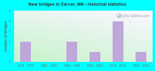
- New bridges - historical statistics
- 21970-1979
- 21990-1999
- 12000-2009
- 42010-2019
- 12020-2022


- Bridge Condition - Deck
- 25.0%Excellent
- 25.0%Very good
- 50.0%Good

- Bridge Condition - Superstructure
- 50.0%Excellent
- 25.0%Very good
- 25.0%Good

- Bridge Condition - Substructure
- 50.0%Excellent
- 50.0%Good

- Bridge Condition - Channel
- 12.5%Very good
- 25.0%Good
- 25.0%Satisfactory
- 25.0%Fair
- 12.5%Poor

- Bridge Condition - Culverts
- 40.0%Very good
- 40.0%Satisfactory
- 20.0%Poor
Find on map >> Show street view
Structure Number: 10518, Location: 1.6 MI E OF JCT CSAH 41 (Lat: 44.734428, Lng: -93.707864), Route carried "on" structure: County highway 73, Year Built: 1977, Status: Open, Structure Length: 0.63m (2.07ft), Average Daily Traffic: 40 (year 1986), Average Future Daily Traffic: 40 (year 2029), Features Intersected: BEVENS CREEK
Minimum Vertical Clearance: 30+ m (98+ ft), Kilometerpoint: 0.000, Lanes on structure: 2, Owner: Town or Township Highway Agency, Approaching Roadway Width: 8.5m (27.9ft), Material/Design: Steel, Design/Construction: Culvert, Number Of Spans In Main Unit: 1, Length of Maximum Span: 6.3m (20.7ft)
Condition: Channel: Satisfactory, Culverts: Poor, Operating Rating: 42.1 metric tons, Method Used To Determine Operating Rating: Load and Resistance Factor Rating (LRFR) rating reported by rating factor(RF) method using HL-93 loadings, Inventory Rating: 32.4 metric tons, Method Used To Determine Inventory Rating: Load and Resistance Factor Rating (LRFR) rating reported by rating factor(RF) method using HL-93 loadings, Structural Evaluation: Meets minimum limits, Waterway Adequacy: Equal to present desirable criteria, Approach Roadway Alignment: Equal to present minimum criteria, Designated Inspection Frequency: Every 12 months, Inspection Date: October 2021
Find on map >> Show street view
Structure Number: 10519, Location: 1.5 MI W OF JCT CSAH 43 (Lat: 44.767475, Lng: -93.710717), Route carried "on" structure: County highway 22, Year Built: 1978, Status: Open, Structure Length: 0.95m (3.12ft), Average Daily Traffic: 75 (year 1986), Average Future Daily Traffic: 75 (year 2029), Design Load: HS 20, Features Intersected: CARVER CREEK
Minimum Vertical Clearance: 30+ m (98+ ft), Kilometerpoint: 0.000, Lanes on structure: 2, Owner: Town or Township Highway Agency, Approaching Roadway Width: 8.5m (27.9ft), Material/Design: Concrete, Design/Construction: Culvert, Number Of Spans In Main Unit: 2, Length of Maximum Span: 4.3m (14.1ft)
Condition: Channel: Poor, Culverts: Satisfactory, Operating Rating: 53.9 metric tons, Method Used To Determine Operating Rating: Assigned ratings based on Allowable Stress Design (ASD) reported in metric tons, Inventory Rating: 35.9 metric tons, Method Used To Determine Inventory Rating: Assigned ratings based on Allowable Stress Design (ASD) reported in metric tons, Structural Evaluation: Equal to present minimum criteria, Waterway Adequacy: Equal to present desirable criteria, Approach Roadway Alignment: Better than present minimum criteria, Designated Inspection Frequency: Every 24 months, Inspection Date: October 2021
Find on map >> Show street view
Structure Number: 10535, Location: 0.03 MI SE JCT CSAH 40 (Lat: 44.751933, Lng: -93.638681), Route carried "on" structure: City street 51, Year Built: 1994, Status: Open, Structure Length: 2.24m (7.35ft), Average Daily Traffic: 250 (year 1999), Average Future Daily Traffic: 250 (year 2029), Design Load: HS 25 or greater, Features Intersected: CARVER CREEK
Minimum Vertical Clearance: 30+ m (98+ ft), Kilometerpoint: 0.000, Lanes on structure: 2, Owner: City or Municipal Highway Agency, Approaching Roadway Width: 11.0m (36.1ft), Material/Design: Prestressed concrete, Design/Construction: Stringer/Multi-beam, Number Of Spans In Main Unit: 1, Length of Maximum Span: 21.3m (69.9ft), Curb-To-Curb Width: 11.0m (36.1ft), Out-to-Out Width: 14.4m (47.2ft)
Condition: Deck: Good, Superstructure: Very good, Substructure: Good, Channel: Fair, Operating Rating: 75.3 metric tons, Method Used To Determine Operating Rating: Load Factor (LF), Inventory Rating: 45.1 metric tons, Method Used To Determine Inventory Rating: Load Factor (LF), Structural Evaluation: Better than present minimum criteria, Deck Geometry: Equal to present desirable criteria, Waterway Adequacy: Equal to present desirable criteria, Approach Roadway Alignment: Equal to present desirable criteria, Designated Inspection Frequency: Every 24 months, Inspection Date: October 2021, Deck Structure Type: Concrete Cast-file-Place, Wearing Surface/Protective System: Wearing Surface: Monolithic Concrete, Deck Protection: Epoxy Coated Reinforcing
Find on map >> Show street view
Structure Number: 10537, Location: 0.5 MI NE OF JCT CSAH 45 (Lat: 44.750306, Lng: -93.649886), Route carried "on" structure: County highway 11, Year Built: 2003, Status: Open, Structure Length: 1.40m (4.59ft), Average Daily Traffic: 6,900 (year 2017), Average Future Daily Traffic: 6,900 (year 2039), Features Intersected: CARVER CREEK
Minimum Vertical Clearance: 30+ m (98+ ft), Kilometerpoint: 0.000, Lanes on structure: 2, Owner: County Highway Agency, Approaching Roadway Width: 18.6m (61.0ft), Material/Design: Concrete, Design/Construction: Culvert, Number Of Spans In Main Unit: 1, Length of Maximum Span: 12.7m (41.7ft), Curb or Sidewalk Widths: Left: 0.0m, Right: 3.0m (9.8ft)
Condition: Channel: Good, Culverts: Very good, Operating Rating: 49.0 metric tons, Method Used To Determine Operating Rating: Assigned ratings based on Allowable Stress Design (ASD) reported in metric tons, Inventory Rating: 32.7 metric tons, Method Used To Determine Inventory Rating: Assigned ratings based on Allowable Stress Design (ASD) reported in metric tons, Structural Evaluation: Equal to present desirable criteria, Waterway Adequacy: Superior to present desirable criteria, Approach Roadway Alignment: Better than present minimum criteria, Designated Inspection Frequency: Every 48 months, Inspection Date: October 2021
Find on map >> Show street view
Structure Number: 10554, Location: 1.3 MI W OF JCT CSAH 40 (Lat: 44.718711, Lng: -93.708669), Route carried "on" structure: County highway 50, Year Built: 2020, Status: Open, Structure Length: 4.33m (14.21ft), Average Daily Traffic: 974 (year 2020), Average Future Daily Traffic: 3,000 (year 2040), Design Load: HL 93, Features Intersected: BEVENS CREEK
Minimum Vertical Clearance: 30+ m (98+ ft), Kilometerpoint: 0.000, Lanes on structure: 2, Base Highway Network: Yes, Owner: County Highway Agency, Approaching Roadway Width: 12.2m (40.0ft), Skew: 1 degrees, Material/Design: Prestressed concrete, Design/Construction: Stringer/Multi-beam, Number Of Spans In Main Unit: 1, Length of Maximum Span: 42.6m (139.8ft), Curb-To-Curb Width: 12.2m (40.0ft), Out-to-Out Width: 13.1m (43.0ft)
Condition: Deck: Excellent, Superstructure: Excellent, Substructure: Excellent, Channel: Very good, Operating Rating: 83.6 metric tons, Method Used To Determine Operating Rating: Load and Resistance Factor Rating (LRFR) rating reported by rating factor(RF) method using HL-93 loadings, Inventory Rating: 44.4 metric tons, Method Used To Determine Inventory Rating: Load and Resistance Factor Rating (LRFR) rating reported by rating factor(RF) method using HL-93 loadings, Structural Evaluation: Superior to present desirable criteria, Deck Geometry: Equal to present desirable criteria, Waterway Adequacy: Superior to present desirable criteria, Approach Roadway Alignment: Better than present minimum criteria, Designated Inspection Frequency: Every 24 months, Inspection Date: October 2021, Deck Structure Type: Concrete Cast-file-Place, Wearing Surface/Protective System: Wearing Surface: Monolithic Concrete, Deck Protection: Epoxy Coated Reinforcing
Find on map >> Show street view
Structure Number: 10J28, Location: 2.4 MI S OF JCT TH 212 (Lat: 44.740567, Lng: -93.684144), Route carried "on" structure: County highway 43, Year Built: 2014, Status: Open, Structure Length: 1.04m (3.41ft), Average Daily Traffic: 1,150 (year 2016), Truck Traffic: 15%, Average Future Daily Traffic: 1,150 (year 2039), Design Load: HL 93, Features Intersected: CARVER CREEK
Minimum Vertical Clearance: 30+ m (98+ ft), Kilometerpoint: 0.000, Lanes on structure: 2, Base Highway Network: Yes, Owner: County Highway Agency, Approaching Roadway Width: 12.2m (40.0ft), Material/Design: Concrete, Design/Construction: Culvert, Number Of Spans In Main Unit: 2, Length of Maximum Span: 4.9m (16.1ft)
Condition: Channel: Good, Culverts: Very good, Operating Rating: 42.1 metric tons, Method Used To Determine Operating Rating: Assigned ratings based on Load and Resistance Factor Design (LRFD) reported by rating factor (RF) using HL93 loadings, Inventory Rating: 32.4 metric tons, Method Used To Determine Inventory Rating: Assigned ratings based on Load and Resistance Factor Design (LRFD) reported by rating factor (RF) using HL93 loadings, Structural Evaluation: Equal to present desirable criteria, Waterway Adequacy: Superior to present desirable criteria, Approach Roadway Alignment: Better than present minimum criteria, Designated Inspection Frequency: Every 48 months, Inspection Date: October 2021
Find on map >> Show street view
Structure Number: 70041, Location: 0.8 MI N OF JCT TH 169 (Lat: 44.774475, Lng: -93.589469), Route carried "on" structure: State highway 41, Year Built: 1998, Status: Open, Structure Length: 7.61m (24.97ft), Average Daily Traffic: 18,467 (year 2019), Truck Traffic: 6%, Average Future Daily Traffic: 18,200 (year 2039), Design Load: HS 25 or greater, Features Intersected: Minnesota River Overflow
Minimum Vertical Clearance: 30+ m (98+ ft), Kilometerpoint: 0.000, Lanes on structure: 2, Base Highway Network: Yes, Owner: State Highway Agency, Approaching Roadway Width: 13.4m (44.0ft), Material/Design: Prestressed concrete, Design/Construction: Stringer/Multi-beam, Number Of Spans In Main Unit: 3, Length of Maximum Span: 25.1m (82.3ft), Curb-To-Curb Width: 21.2m (69.6ft), Out-to-Out Width: 22.2m (72.8ft)
Condition: Deck: Good, Superstructure: Good, Substructure: Good, Channel: Satisfactory, Operating Rating: 75.1 metric tons, Method Used To Determine Operating Rating: Load Factor (LF), Inventory Rating: 44.4 metric tons, Method Used To Determine Inventory Rating: Load Factor (LF), Structural Evaluation: Better than present minimum criteria, Deck Geometry: Superior to present desirable criteria, Waterway Adequacy: High priority of corrective action, Approach Roadway Alignment: Equal to present desirable criteria, Length Of Structure Improvement: 2.56m (8.40ft), Designated Inspection Frequency: Every 24 months, Inspection Date: July 2021, Bridge Improvement Cost: $999,999,000, Deck Structure Type: Concrete Cast-file-Place, Wearing Surface/Protective System: Wearing Surface: Monolithic Concrete, Deck Protection: Epoxy Coated Reinforcing
Find on map >> Show street view
Structure Number: 70046, Location: 5.4 MI N OF JORDAN (Lat: 44.737000, Lng: -93.588378), Route carried "on" structure: County highway 8, Year Built: 2019, Status: Open, Structure Length: 7.13m (23.39ft), Average Daily Traffic: 1 (year 2019), Average Future Daily Traffic: 7,600 (year 2038), Design Load: HL 93, Features Intersected: US 169
Minimum Vertical Clearance: 30+ m (98+ ft), Kilometerpoint: 0.000, Lanes on structure: 2, Lanes under structure: 4, Owner: County Highway Agency, Approaching Roadway Width: 12.2m (40.0ft), Skew: 1 degrees, Material/Design: Prestressed concrete, Design/Construction: Stringer/Multi-beam, Number Of Spans In Main Unit: 2, Length of Maximum Span: 35.2m (115.5ft), Curb or Sidewalk Widths: Left: 3.5m (11.5ft), Right: 0.0m, Curb-To-Curb Width: 12.2m (40.0ft), Out-to-Out Width: 17.1m (56.1ft)
Condition: Deck: Very good, Superstructure: Excellent, Substructure: Excellent, Operating Rating: 57.0 metric tons, Method Used To Determine Operating Rating: Load and Resistance Factor Rating (LRFR) rating reported by rating factor(RF) method using HL-93 loadings, Inventory Rating: 38.6 metric tons, Method Used To Determine Inventory Rating: Load and Resistance Factor Rating (LRFR) rating reported by rating factor(RF) method using HL-93 loadings, Structural Evaluation: Superior to present desirable criteria, Deck Geometry: Superior to present desirable criteria, Underclear: Equal to present desirable criteria, Approach Roadway Alignment: Better than present minimum criteria, Designated Inspection Frequency: Every 24 months, Inspection Date: September 2021, Deck Structure Type: Concrete Cast-file-Place, Wearing Surface/Protective System: Wearing Surface: Monolithic Concrete, Deck Protection: Epoxy Coated Reinforcing
Find on map >> Show street view
Structure Number: 70X04, Location: 2.6 MI S OF JCT TH 41 (Lat: 44.729500, Lng: -93.588100), Route carried "on" structure: US 169, Year Built: 2019, Status: Open, Structure Length: 0.94m (3.08ft), Average Daily Traffic: 30,463 (year 2019), Truck Traffic: 10%, Average Future Daily Traffic: 27,000 (year 2039), Design Load: HL 93, Features Intersected: PICHA CREEK
Minimum Vertical Clearance: 30+ m (98+ ft), Kilometerpoint: 0.000, Lanes on structure: 4, Base Highway Network: Yes, Owner: State Highway Agency, Approaching Roadway Width: 26.0m (85.3ft), Skew: 20 degrees, Material/Design: Concrete, Design/Construction: Culvert, Number Of Spans In Main Unit: 2, Length of Maximum Span: 4.3m (14.1ft), Curb-To-Curb Width: 26.0m (85.3ft), Out-to-Out Width: 26.0m (85.3ft)
Condition: Channel: Fair, Culverts: Satisfactory, Operating Rating: 42.1 metric tons, Method Used To Determine Operating Rating: Load and Resistance Factor Rating (LRFR) rating reported by rating factor(RF) method using HL-93 loadings, Inventory Rating: 32.4 metric tons, Method Used To Determine Inventory Rating: Load and Resistance Factor Rating (LRFR) rating reported by rating factor(RF) method using HL-93 loadings, Structural Evaluation: Equal to present minimum criteria, Deck Geometry: Superior to present desirable criteria, Waterway Adequacy: Equal to present desirable criteria, Approach Roadway Alignment: Equal to present desirable criteria, Designated Inspection Frequency: Every 24 months, Inspection Date: October 2020
Find on map >> Show street view
Structure Number: 70046, Location: 5.4 MI N OF JORDAN (Lat: 44.737000, Lng: -93.588378), Route carried "under" structure: US 169, Year Built: 2019, Structure Length: 0. m, Average Daily Traffic: 30,463 (year 2019), Truck Traffic: 10%, Features Intersected: US 169, Facility Carried by Structure: T 8
Minimum Vertical Clearance: 5.46m (17.91ft), Kilometerpoint: 0.000, Lanes under structure: 4, Material/Design: Prestressed concrete, Design/Construction: Stringer/Multi-beam, Length of Maximum Span: 35.2m (115.5ft)