Bridge Statistics for Brookshire, Texas (TX)
Condition, Traffic, Stress, Structural Evaluation, Project Costs
- National Bridge Inventory (NBI) Statistics
- 25Number of bridges
- 459ft / 140mTotal length
- $186,000Total costs
- 506,319Total average daily traffic
- 151,444Total average daily truck traffic
- National Bridge Inventory (NBI) Registered Bridges for Brookshire
- No street view available for this location
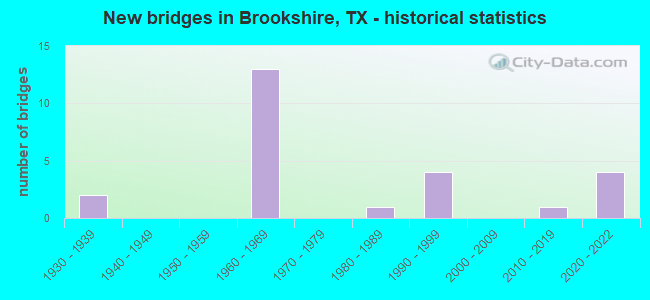
- New bridges - historical statistics
- 21930-1939
- 131960-1969
- 11980-1989
- 41990-1999
- 12010-2019
- 42020-2022


- Bridge Condition - Deck
- 10.5%Very good
- 31.6%Good
- 42.1%Satisfactory
- 15.8%Fair

- Bridge Condition - Superstructure
- 15.8%Very good
- 36.8%Good
- 36.8%Satisfactory
- 10.5%Fair

- Bridge Condition - Substructure
- 15.8%Very good
- 26.3%Good
- 52.6%Satisfactory
- 5.3%Fair

- Bridge Condition - Channel
- 29.4%Good
- 58.8%Satisfactory
- 5.9%Fair
- 5.9%Poor

- Bridge Condition - Culverts
- 33.3%Satisfactory
- 33.3%Poor
- 33.3%Serious
Find on map >> Show street view
Structure Number: 120800AA0398001, Location: 0.10 MI E OF CR 398 (Lat: 29.726956, Lng: -95.944050), Route carried "on" structure: County highway , Year Built: 1993, Status: Posted for load, Structure Length: 1.68m (5.51ft), Average Daily Traffic: 70 (year 2010), Average Future Daily Traffic: 120 (year 2030), Features Intersected: BROOKSHIRE CREEK, Facility Carried by Structure: POOL HILL RD
Minimum Vertical Clearance: 30+ m (98+ ft), Kilometerpoint: 32.187, Lanes on structure: 2, Owner: County Highway Agency, Approaching Roadway Width: 6.1m (20.0ft), Material/Design: Steel, Design/Construction: Culvert, Number Of Spans In Main Unit: 5, Length of Maximum Span: 2.7m (8.9ft), Curb-To-Curb Width: 7.7m (25.3ft), Out-to-Out Width: 12.0m (39.4ft)
Condition: Channel: Satisfactory, Culverts: Serious, Operating Rating: 40.8 metric tons, Method Used To Determine Operating Rating: Load and Resistance Factor (LRFR), Inventory Rating: 31.7 metric tons, Method Used To Determine Inventory Rating: Load and Resistance Factor (LRFR), Structural Evaluation: High priority of corrective action, Deck Geometry: Equal to present minimum criteria, Waterway Adequacy: Meets minimum limits, Approach Roadway Alignment: Equal to present minimum criteria, Bridge Posting: Required (Relationship of Operating Rating to Maximum Legal Load: 0.1 - 9.9% below), Length Of Structure Improvement: 3.05m (10.01ft), Designated Inspection Frequency: Every 24 months, Inspection Date: August 2021, Deck Structure Type: Other, Wearing Surface/Protective System: Wearing Surface: Bituminous
Find on map >> Show street view
Structure Number: 120800AA0803001, Location: 0.20 MI W OF CHIPPENDALE (Lat: 29.731933, Lng: -95.952281), Route carried "on" structure: County highway , Year Built: 1960, Status: Posted for load, Structure Length: 1.59m (5.22ft), Average Daily Traffic: 50 (year 2010), Average Future Daily Traffic: 50 (year 2030), Features Intersected: BROOKSHIRE CREEK, Facility Carried by Structure: PECAN HILL RD
Minimum Vertical Clearance: 30+ m (98+ ft), Kilometerpoint: 32.187, Lanes on structure: 1, Owner: County Highway Agency, Approaching Roadway Width: 5.8m (19.0ft), Material/Design: Wood or Timber, Design/Construction: Stringer/Multi-beam, Number Of Spans In Main Unit: 3, Length of Maximum Span: 5.2m (17.1ft), Curb-To-Curb Width: 6.2m (20.3ft), Out-to-Out Width: 6.7m (22.0ft)
Condition: Deck: Good, Superstructure: Satisfactory, Substructure: Fair, Channel: Good, Operating Rating: 23.6 metric tons, Method Used To Determine Operating Rating: Allowable Stress (AS), Inventory Rating: 17.2 metric tons, Method Used To Determine Inventory Rating: Allowable Stress (AS), Structural Evaluation: Somewhat better than minimum adequacy, Deck Geometry: Somewhat better than minimum adequacy, Waterway Adequacy: Better than present minimum criteria, Approach Roadway Alignment: Equal to present desirable criteria, Bridge Posting: Required (Relationship of Operating Rating to Maximum Legal Load: 20.0 - 29.9% below), Length Of Structure Improvement: 2.32m (7.61ft), Designated Inspection Frequency: Every 24 months, Inspection Date: August 2021, Bridge Improvement Cost: $55,000, Roadway Improvement Cost: $14,000, Total Project Cost: $69,000, Deck Structure Type: Wood or Timber, Wearing Surface/Protective System: Wearing Surface: Wood or Timber
Find on map >> Show street view
Structure Number: 120800AA0803002, Location: 0.50 MI W OF CR 398 (Lat: 29.733144, Lng: -95.945842), Route carried "on" structure: County highway , Year Built: 1997, Status: Open, Structure Length: 1.59m (5.22ft), Average Daily Traffic: 90 (year 2010), Average Future Daily Traffic: 50 (year 2030), Design Load: HS 20, Features Intersected: BROOKSHIRE CREEK, Facility Carried by Structure: PECAN HILL RD
Minimum Vertical Clearance: 30+ m (98+ ft), Kilometerpoint: 64.374, Lanes on structure: 2, Owner: County Highway Agency, Approaching Roadway Width: 5.8m (19.0ft), Skew: 1 degrees, Material/Design: Steel, Design/Construction: Culvert, Number Of Spans In Main Unit: 5, Length of Maximum Span: 2.4m (7.9ft), Curb-To-Curb Width: 7.0m (23.0ft), Out-to-Out Width: 13.7m (44.9ft)
Condition: Channel: Poor, Culverts: Poor, Operating Rating: 54.4 metric tons, Method Used To Determine Operating Rating: Assigned rating based on Load Factor Design (LFD) reported in metric tons, Inventory Rating: 32.7 metric tons, Method Used To Determine Inventory Rating: Assigned rating based on Load Factor Design (LFD) reported in metric tons, Structural Evaluation: Meets minimum limits, Deck Geometry: Somewhat better than minimum adequacy, Waterway Adequacy: Better than present minimum criteria, Approach Roadway Alignment: Equal to present desirable criteria, Length Of Structure Improvement: 1.59m (5.22ft), Designated Inspection Frequency: Every 24 months, Inspection Date: August 2021, Bridge Improvement Cost: $22,000, Roadway Improvement Cost: $6,000, Total Project Cost: $28,000, Deck Structure Type: Other, Wearing Surface/Protective System: Wearing Surface: Bituminous
Find on map >> Show street view
Structure Number: 122370027104034, Location: 1.00 MI W OF FM 1489 (Lat: 29.783222, Lng: -95.986611), Route carried "on" structure: ServiceInterstate 10, Year Built: 1938, Status: Open, Structure Length: 9.75m (31.99ft), Average Daily Traffic: 1,010 (year 2013), Truck Traffic: 18%, Average Future Daily Traffic: 1,410 (year 2033), Design Load: H 15, Features Intersected: HADY CREEK
Minimum Vertical Clearance: 30+ m (98+ ft), Kilometerpoint: 5.053, Lanes on structure: 2, Owner: State Highway Agency, Approaching Roadway Width: 6.7m (22.0ft), Material/Design: Steel, Design/Construction: Stringer/Multi-beam, Number Of Spans In Main Unit: 8, Length of Maximum Span: 12.2m (40.0ft), Curb-To-Curb Width: 7.2m (23.6ft), Out-to-Out Width: 8.7m (28.5ft)
Condition: Deck: Satisfactory, Superstructure: Satisfactory, Substructure: Satisfactory, Channel: Satisfactory, Operating Rating: 41.7 metric tons, Method Used To Determine Operating Rating: Load Factor (LF), Inventory Rating: 25.4 metric tons, Method Used To Determine Inventory Rating: Load Factor (LF), Structural Evaluation: Equal to present minimum criteria, Deck Geometry: High priority of replacement, Waterway Adequacy: Better than present minimum criteria, Approach Roadway Alignment: Equal to present desirable criteria, Length Of Structure Improvement: 9.75m (31.99ft), Designated Inspection Frequency: Every 24 months, Inspection Date: September 2020, Bridge Improvement Cost: $15,000, Roadway Improvement Cost: $4,000, Total Project Cost: $19,000, Deck Structure Type: Concrete Cast-file-Place, Wearing Surface/Protective System: Wearing Surface: Bituminous
Find on map >> Show street view
Structure Number: 122370027104256, Location: 0.75 MI W OF FM 1489 (Lat: 29.780664, Lng: -95.979081), Route carried "on" structure: ServiceInterstate 10, Year Built: 1967, Status: Open, Structure Length: 9.39m (30.81ft), Average Daily Traffic: 23,460 (year 2010), Truck Traffic: 28%, Average Future Daily Traffic: 44,080 (year 2027), Design Load: H 20, Features Intersected: HADY CREEK
Minimum Vertical Clearance: 30+ m (98+ ft), Kilometerpoint: 5.826, Lanes on structure: 1, Owner: State Highway Agency, Approaching Roadway Width: 6.1m (20.0ft), Skew: 4 degrees, Material/Design: Concrete, Design/Construction: Stringer/Multi-beam, Number Of Spans In Main Unit: 9, Length of Maximum Span: 10.4m (34.1ft), Curb-To-Curb Width: 7.3m (24.0ft), Out-to-Out Width: 8.7m (28.5ft)
Condition: Deck: Satisfactory, Superstructure: Fair, Substructure: Satisfactory, Channel: Satisfactory, Operating Rating: 55.3 metric tons, Method Used To Determine Operating Rating: Load Factor (LF), Inventory Rating: 32.7 metric tons, Method Used To Determine Inventory Rating: Load Factor (LF), Structural Evaluation: Somewhat better than minimum adequacy, Deck Geometry: High priority of replacement, Waterway Adequacy: Better than present minimum criteria, Approach Roadway Alignment: Equal to present desirable criteria, Length Of Structure Improvement: 9.36m (30.71ft), Designated Inspection Frequency: Every 24 months, Inspection Date: September 2020, Deck Structure Type: Concrete Cast-file-Place
Find on map >> Show street view
Structure Number: 122370027104257, Location: 0.70 MI W OF FM 1489 (Lat: 29.782339, Lng: -95.980539), Route carried "on" structure: ServiceInterstate 10, Year Built: 1967, Status: Open, Structure Length: 3.72m (12.20ft), Average Daily Traffic: 23,460 (year 2010), Truck Traffic: 28%, Average Future Daily Traffic: 44,080 (year 2028), Design Load: HS 20, Features Intersected: KELLNER CREEK
Minimum Vertical Clearance: 30+ m (98+ ft), Kilometerpoint: 5.629, Lanes on structure: 1, Owner: State Highway Agency, Approaching Roadway Width: 7.3m (24.0ft), Material/Design: Concrete, Design/Construction: Stringer/Multi-beam, Number Of Spans In Main Unit: 4, Length of Maximum Span: 9.1m (29.9ft), Curb-To-Curb Width: 7.3m (24.0ft), Out-to-Out Width: 8.7m (28.5ft)
Condition: Deck: Satisfactory, Superstructure: Satisfactory, Substructure: Satisfactory, Channel: Good, Operating Rating: 59.9 metric tons, Method Used To Determine Operating Rating: Load Factor (LF), Inventory Rating: 36.3 metric tons, Method Used To Determine Inventory Rating: Load Factor (LF), Structural Evaluation: Equal to present minimum criteria, Deck Geometry: High priority of replacement, Waterway Adequacy: Better than present minimum criteria, Approach Roadway Alignment: Equal to present desirable criteria, Designated Inspection Frequency: Every 24 months, Inspection Date: September 2020, Deck Structure Type: Concrete Cast-file-Place
Find on map >> Show street view
Structure Number: 122370027104258, Location: 0.70 MI W OF FM 1489 (Lat: 29.782678, Lng: -95.980478), Route carried "on" structure: Interstate 10, Year Built: 1967, Status: Open, Structure Length: 4.30m (14.11ft), Average Daily Traffic: 29,754 (year 2017), Truck Traffic: 33%, Average Future Daily Traffic: 37,440 (year 2033), Design Load: HS 20, Features Intersected: KELLNER CREEK
Minimum Vertical Clearance: 30+ m (98+ ft), Kilometerpoint: 5.629, Lanes on structure: 2, Owner: State Highway Agency, Approaching Roadway Width: 11.6m (38.1ft), Material/Design: Prestressed concrete, Design/Construction: Stringer/Multi-beam, Number Of Spans In Main Unit: 3, Length of Maximum Span: 15.2m (49.9ft), Curb-To-Curb Width: 11.7m (38.4ft), Out-to-Out Width: 12.8m (42.0ft)
Condition: Deck: Good, Superstructure: Good, Substructure: Satisfactory, Channel: Satisfactory, Operating Rating: 54.4 metric tons, Method Used To Determine Operating Rating: Assigned rating based on Load Factor Design (LFD) reported in metric tons, Inventory Rating: 32.7 metric tons, Method Used To Determine Inventory Rating: Assigned rating based on Load Factor Design (LFD) reported in metric tons, Structural Evaluation: Equal to present minimum criteria, Deck Geometry: Equal to present minimum criteria, Waterway Adequacy: Equal to present minimum criteria, Approach Roadway Alignment: Equal to present desirable criteria, Designated Inspection Frequency: Every 24 months, Inspection Date: September 2020, Deck Structure Type: Concrete Cast-file-Place
Find on map >> Show street view
Structure Number: 122370027104259, Location: 3.30 MI E OF BRAZOS RI (Lat: 29.781194, Lng: -95.985308), Route carried "on" structure: US 90, Year Built: 1967, Status: Open, Structure Length: 23.77m (77.99ft), Average Daily Traffic: 1,510 (year 2010), Truck Traffic: 10%, Average Future Daily Traffic: 2,930 (year 2027), Design Load: H 20, Features Intersected: IH 10 & HADY CREEK, Facility Carried by Structure: DONIGAN RD
Minimum Vertical Clearance: 30+ m (98+ ft), Kilometerpoint: 0.248, Lanes on structure: 2, Lanes under structure: 4, Owner: State Highway Agency, Approaching Roadway Width: 8.5m (27.9ft), Skew: 4 degrees, Material/Design: Prestressed concrete, Design/Construction: Stringer/Multi-beam, Number Of Spans In Main Unit: 9, Number Of Approach Spans: 2, Length of Maximum Span: 24.4m (80.1ft), Curb-To-Curb Width: 8.5m (27.9ft), Out-to-Out Width: 10.0m (32.8ft)
Condition: Deck: Fair, Superstructure: Satisfactory, Substructure: Satisfactory, Channel: Good, Operating Rating: 62.6 metric tons, Method Used To Determine Operating Rating: Load Factor (LF), Inventory Rating: 29.9 metric tons, Method Used To Determine Inventory Rating: Load Factor (LF), Structural Evaluation: Equal to present minimum criteria, Deck Geometry: Somewhat better than minimum adequacy, Underclear: Somewhat better than minimum adequacy, Waterway Adequacy: Superior to present desirable criteria, Approach Roadway Alignment: Equal to present desirable criteria, Length Of Structure Improvement: 23.84m (78.22ft), Designated Inspection Frequency: Every 24 months, Inspection Date: September 2020, Deck Structure Type: Concrete Cast-file-Place
Find on map >> Show street view
Structure Number: 12237002710426, Location: 1.30 MI W OF FM 1489 (Lat: 29.782472, Lng: -95.985906), Route carried "on" structure: Interstate 10, Year Built: 1967, Status: Open, Structure Length: 13.41m (44.00ft), Average Daily Traffic: 33,900 (year 2018), Truck Traffic: 33%, Average Future Daily Traffic: 37,440 (year 2033), Design Load: HS 20, Features Intersected: HADY CREEK
Minimum Vertical Clearance: 30+ m (98+ ft), Kilometerpoint: 5.044, Lanes on structure: 2, Owner: State Highway Agency, Approaching Roadway Width: 11.6m (38.1ft), Skew: 4 degrees, Material/Design: Prestressed concrete, Design/Construction: Stringer/Multi-beam, Number Of Spans In Main Unit: 7, Length of Maximum Span: 19.8m (65.0ft), Curb-To-Curb Width: 11.7m (38.4ft), Out-to-Out Width: 12.8m (42.0ft)
Condition: Deck: Fair, Superstructure: Good, Substructure: Satisfactory, Channel: Satisfactory, Operating Rating: 54.4 metric tons, Method Used To Determine Operating Rating: Assigned rating based on Load Factor Design (LFD) reported in metric tons, Inventory Rating: 32.7 metric tons, Method Used To Determine Inventory Rating: Assigned rating based on Load Factor Design (LFD) reported in metric tons, Structural Evaluation: Equal to present minimum criteria, Deck Geometry: Equal to present minimum criteria, Waterway Adequacy: Equal to present minimum criteria, Approach Roadway Alignment: Equal to present desirable criteria, Designated Inspection Frequency: Every 24 months, Inspection Date: September 2020, Deck Structure Type: Concrete Cast-file-Place
Find on map >> Show street view
Structure Number: 122370027104279, Location: 1.00 MI E OF FM 359 (Lat: 29.778894, Lng: -95.935772), Route carried "on" structure: Interstate 10, Year Built: 1967, Year Reconstructed: 1987, Status: Open, Structure Length: 2.50m (8.20ft), Average Daily Traffic: 31,878 (year 2017), Truck Traffic: 33%, Average Future Daily Traffic: 41,580 (year 2033), Design Load: HS 20, Features Intersected: BROOKSHIRE CREEK
Minimum Vertical Clearance: 30+ m (98+ ft), Kilometerpoint: 10.065, Lanes on structure: 3, Owner: State Highway Agency, Approaching Roadway Width: 17.7m (58.1ft), Skew: 1 degrees, Material/Design: Concrete, Design/Construction: Stringer/Multi-beam, Number Of Spans In Main Unit: 2, Length of Maximum Span: 12.5m (41.0ft), Curb-To-Curb Width: 17.9m (58.7ft), Out-to-Out Width: 21.3m (69.9ft)
Condition: Deck: Fair, Superstructure: Fair, Substructure: Satisfactory, Channel: Good, Operating Rating: 68.0 metric tons, Method Used To Determine Operating Rating: Load Factor (LF), Inventory Rating: 40.8 metric tons, Method Used To Determine Inventory Rating: Load Factor (LF), Structural Evaluation: Somewhat better than minimum adequacy, Deck Geometry: Better than present minimum criteria, Waterway Adequacy: Equal to present minimum criteria, Approach Roadway Alignment: Equal to present desirable criteria, Designated Inspection Frequency: Every 24 months, Inspection Date: September 2020, Deck Structure Type: Concrete Cast-file-Place
Find on map >> Show street view
Structure Number: 12237002710428, Location: 1.00 MI E OF FM 359 (Lat: 29.778781, Lng: -95.935789), Route carried "on" structure: Interstate 10, Year Built: 1967, Year Reconstructed: 1987, Status: Open, Structure Length: 2.50m (8.20ft), Average Daily Traffic: 30,736 (year 2017), Truck Traffic: 33%, Average Future Daily Traffic: 41,580 (year 2033), Design Load: HS 20, Features Intersected: BROOKSHIRE CREEK
Minimum Vertical Clearance: 30+ m (98+ ft), Kilometerpoint: 10.065, Lanes on structure: 3, Owner: State Highway Agency, Approaching Roadway Width: 17.7m (58.1ft), Skew: 1 degrees, Material/Design: Concrete, Design/Construction: Stringer/Multi-beam, Number Of Spans In Main Unit: 2, Length of Maximum Span: 12.5m (41.0ft), Curb-To-Curb Width: 17.9m (58.7ft), Out-to-Out Width: 21.3m (69.9ft)
Condition: Deck: Satisfactory, Superstructure: Satisfactory, Substructure: Satisfactory, Channel: Satisfactory, Operating Rating: 68.0 metric tons, Method Used To Determine Operating Rating: Load Factor (LF), Inventory Rating: 40.8 metric tons, Method Used To Determine Inventory Rating: Load Factor (LF), Structural Evaluation: Equal to present minimum criteria, Deck Geometry: Better than present minimum criteria, Waterway Adequacy: Equal to present minimum criteria, Approach Roadway Alignment: Equal to present desirable criteria, Designated Inspection Frequency: Every 24 months, Inspection Date: September 2020, Deck Structure Type: Concrete Cast-file-Place
Find on map >> Show street view
Structure Number: 122370027104281, Location: 1.90 MI E OF FM 359 (Lat: 29.777239, Lng: -95.920497), Route carried "on" structure: County highway , Year Built: 1967, Status: Open, Structure Length: 7.01m (23.00ft), Average Daily Traffic: 135 (year 2011), Average Future Daily Traffic: 150 (year 2031), Design Load: H 20, Features Intersected: IH 10, Facility Carried by Structure: WOODS RD
Minimum Vertical Clearance: 30+ m (98+ ft), Kilometerpoint: 1.127, Lanes on structure: 2, Lanes under structure: 6, Owner: State Highway Agency, Approaching Roadway Width: 10.4m (34.1ft), Material/Design: Prestressed concrete, Design/Construction: Stringer/Multi-beam, Number Of Spans In Main Unit: 2, Number Of Approach Spans: 2, Length of Maximum Span: 22.9m (75.1ft), Curb-To-Curb Width: 7.3m (24.0ft), Out-to-Out Width: 8.3m (27.2ft)
Condition: Deck: Satisfactory, Superstructure: Good, Substructure: Satisfactory, Operating Rating: 68.0 metric tons, Method Used To Determine Operating Rating: Load Factor (LF), Inventory Rating: 33.6 metric tons, Method Used To Determine Inventory Rating: Load Factor (LF), Structural Evaluation: Equal to present minimum criteria, Deck Geometry: Somewhat better than minimum adequacy, Underclear: Somewhat better than minimum adequacy, Approach Roadway Alignment: Equal to present desirable criteria, Designated Inspection Frequency: Every 24 months, Inspection Date: September 2020, Deck Structure Type: Concrete Cast-file-Place
Find on map >> Show street view
Structure Number: 122370027104282, Location: 3.00 MI E OF FM 359 (Lat: 29.777214, Lng: -95.901336), Route carried "on" structure: County highway , Year Built: 1967, Status: Open, Structure Length: 7.01m (23.00ft), Average Daily Traffic: 20 (year 2011), Average Future Daily Traffic: 20 (year 2031), Design Load: H 20, Features Intersected: IH 10, Facility Carried by Structure: IGLOO RD
Minimum Vertical Clearance: 30+ m (98+ ft), Kilometerpoint: 0.113, Lanes on structure: 2, Lanes under structure: 6, Owner: State Highway Agency, Approaching Roadway Width: 9.8m (32.2ft), Material/Design: Prestressed concrete, Design/Construction: Stringer/Multi-beam, Number Of Spans In Main Unit: 2, Number Of Approach Spans: 2, Length of Maximum Span: 22.9m (75.1ft), Curb-To-Curb Width: 7.3m (24.0ft), Out-to-Out Width: 8.3m (27.2ft)
Condition: Deck: Satisfactory, Superstructure: Good, Substructure: Good, Operating Rating: 68.0 metric tons, Method Used To Determine Operating Rating: Load Factor (LF), Inventory Rating: 33.6 metric tons, Method Used To Determine Inventory Rating: Load Factor (LF), Structural Evaluation: Better than present minimum criteria, Deck Geometry: Equal to present minimum criteria, Underclear: Somewhat better than minimum adequacy, Approach Roadway Alignment: Equal to present desirable criteria, Length Of Structure Improvement: 7.07m (23.20ft), Designated Inspection Frequency: Every 24 months, Inspection Date: September 2020, Deck Structure Type: Concrete Cast-file-Place
Find on map >> Show street view
Structure Number: 122370027104722, Location: 4.30 MI E OF BRAZOS RI (Lat: 29.778850, Lng: -95.967547), Route carried "on" structure: State highway 1489, Year Built: 2020, Status: Open, Structure Length: 7.32m (24.02ft), Average Daily Traffic: 4,580 (year 2013), Truck Traffic: 12%, Average Future Daily Traffic: 6,410 (year 2033), Design Load: HL 93, Features Intersected: IH 10
Minimum Vertical Clearance: 30+ m (98+ ft), Kilometerpoint: 0.779, Lanes on structure: 4, Lanes under structure: 4, Owner: State Highway Agency, Approaching Roadway Width: 24.4m (80.1ft), Skew: 20 degrees, Material/Design: Prestressed concrete, Design/Construction: Stringer/Multi-beam, Number Of Spans In Main Unit: 2, Length of Maximum Span: 36.6m (120.1ft), Curb or Sidewalk Widths: Left: 2.0m (6.6ft), Right: 2.0m (6.6ft), Curb-To-Curb Width: 24.4m (80.1ft), Out-to-Out Width: 30.8m (101.0ft)
Condition: Deck: Good, Superstructure: Very good, Substructure: Very good, Operating Rating: 54.4 metric tons, Method Used To Determine Operating Rating: Assigned ratings based on Load and Resistance Factor Design (LRFD) reported in metric tons, Inventory Rating: 32.7 metric tons, Method Used To Determine Inventory Rating: Assigned ratings based on Load and Resistance Factor Design (LRFD) reported in metric tons, Structural Evaluation: Equal to present desirable criteria, Deck Geometry: Superior to present desirable criteria, Underclear: High priority of corrective action, Approach Roadway Alignment: Equal to present desirable criteria, Designated Inspection Frequency: Every 24 months, Inspection Date: September 2020, Deck Structure Type: Concrete Cast-file-Place
Find on map >> Show street view
Structure Number: 122370027104727, Location: 0.70 MI W OF FM 1489 (Lat: 29.780333, Lng: -95.979119), Route carried "on" structure: Interstate 10, Year Built: 2020, Status: Open, Structure Length: 11.13m (36.52ft), Average Daily Traffic: 26,750 (year 2013), Truck Traffic: 33%, Average Future Daily Traffic: 1 (year 1900), Design Load: HL 93, Features Intersected: HADY CREEK
Minimum Vertical Clearance: 30+ m (98+ ft), Kilometerpoint: 5.831, Lanes on structure: 2, Base Highway Network: Yes, Owner: State Highway Agency, Approaching Roadway Width: 7.3m (24.0ft), Skew: 3 degrees, Material/Design: Prestressed concrete, Design/Construction: Stringer/Multi-beam, Number Of Spans In Main Unit: 5, Length of Maximum Span: 24.4m (80.1ft), Curb-To-Curb Width: 7.3m (24.0ft), Out-to-Out Width: 20.9m (68.6ft)
Condition: Deck: Good, Superstructure: Good, Substructure: Good, Channel: Satisfactory, Operating Rating: 54.4 metric tons, Method Used To Determine Operating Rating: Assigned ratings based on Load and Resistance Factor Design (LRFD) reported in metric tons, Inventory Rating: 32.7 metric tons, Method Used To Determine Inventory Rating: Assigned ratings based on Load and Resistance Factor Design (LRFD) reported in metric tons, Structural Evaluation: Better than present minimum criteria, Deck Geometry: High priority of replacement, Waterway Adequacy: Better than present minimum criteria, Approach Roadway Alignment: Equal to present desirable criteria, Designated Inspection Frequency: Every 24 months, Inspection Date: September 2020, Deck Structure Type: Concrete Cast-file-Place
Find on map >> Show street view
Structure Number: 122370027104728, Location: 5.3 MI E OF BRAZOS RIVER (Lat: 29.778850, Lng: -95.951347), Route carried "on" structure: Interstate 10, Year Built: 2020, Status: Open, Structure Length: 10.97m (35.99ft), Average Daily Traffic: 57,770 (year 2017), Truck Traffic: 33%, Average Future Daily Traffic: 1 (year 1900), Design Load: HL 93, Features Intersected: FM 359
Minimum Vertical Clearance: 30+ m (98+ ft), Kilometerpoint: 8.534, Lanes on structure: 6, Lanes under structure: 6, Base Highway Network: Yes, Owner: State Highway Agency, Approaching Roadway Width: 36.6m (120.1ft), Skew: 30 degrees, Material/Design: Prestressed concrete, Design/Construction: Stringer/Multi-beam, Number Of Spans In Main Unit: 3, Length of Maximum Span: 36.6m (120.1ft), Curb-To-Curb Width: 36.6m (120.1ft), Out-to-Out Width: 37.9m (124.3ft)
Condition: Deck: Very good, Superstructure: Very good, Substructure: Very good, Operating Rating: 54.4 metric tons, Method Used To Determine Operating Rating: Assigned ratings based on Load and Resistance Factor Design (LRFD) reported in metric tons, Inventory Rating: 32.7 metric tons, Method Used To Determine Inventory Rating: Assigned ratings based on Load and Resistance Factor Design (LRFD) reported in metric tons, Structural Evaluation: Equal to present desirable criteria, Deck Geometry: Superior to present desirable criteria, Underclear: Superior to present desirable criteria, Approach Roadway Alignment: Equal to present desirable criteria, Designated Inspection Frequency: Every 24 months, Inspection Date: December 2020, Deck Structure Type: Concrete Cast-file-Place
Find on map >> Show street view
Structure Number: 12237002710473, Location: 2.1 MI E OF BRAZOS RIVER (Lat: 29.778614, Lng: -96.004611), Route carried "on" structure: Interstate 10, Year Built: 2020, Status: Open, Structure Length: 3.96m (12.99ft), Average Daily Traffic: 53,400 (year 2013), Truck Traffic: 18%, Average Future Daily Traffic: 1 (year 1900), Design Load: HL 93, Features Intersected: PEACH RIDGE RD
Minimum Vertical Clearance: 30+ m (98+ ft), Kilometerpoint: 3.330, Lanes on structure: 6, Lanes under structure: 2, Base Highway Network: Yes, Owner: State Highway Agency, Approaching Roadway Width: 36.6m (120.1ft), Skew: 30 degrees, Material/Design: Prestressed concrete, Design/Construction: Stringer/Multi-beam, Number Of Spans In Main Unit: 1, Length of Maximum Span: 39.6m (129.9ft), Curb-To-Curb Width: 36.6m (120.1ft), Out-to-Out Width: 37.9m (124.3ft)
Condition: Deck: Very good, Superstructure: Very good, Substructure: Very good, Operating Rating: 54.4 metric tons, Method Used To Determine Operating Rating: Assigned ratings based on Load and Resistance Factor Design (LRFD) reported in metric tons, Inventory Rating: 32.7 metric tons, Method Used To Determine Inventory Rating: Assigned ratings based on Load and Resistance Factor Design (LRFD) reported in metric tons, Structural Evaluation: Equal to present desirable criteria, Deck Geometry: Superior to present desirable criteria, Underclear: Superior to present desirable criteria, Approach Roadway Alignment: Equal to present desirable criteria, Designated Inspection Frequency: Every 24 months, Inspection Date: December 2020, Deck Structure Type: Concrete Cast-file-Place
Find on map >> Show street view
Structure Number: 122370027109033, Location: 0.65 MI W OF FM 1489 (Lat: 29.784892, Lng: -95.979267), Route carried "on" structure: Business US 90, Year Built: 1938, Status: Open, Structure Length: 3.66m (12.01ft), Average Daily Traffic: 1,514 (year 2020), Truck Traffic: 5%, Average Future Daily Traffic: 1,420 (year 2033), Design Load: H 15, Features Intersected: KELLNER CREEK
Minimum Vertical Clearance: 30+ m (98+ ft), Kilometerpoint: 0.972, Lanes on structure: 2, Owner: State Highway Agency, Approaching Roadway Width: 6.7m (22.0ft), Material/Design: Steel, Design/Construction: Stringer/Multi-beam, Number Of Spans In Main Unit: 3, Length of Maximum Span: 12.2m (40.0ft), Curb-To-Curb Width: 7.3m (24.0ft), Out-to-Out Width: 8.8m (28.9ft)
Condition: Deck: Good, Superstructure: Satisfactory, Substructure: Satisfactory, Channel: Satisfactory, Operating Rating: 42.6 metric tons, Method Used To Determine Operating Rating: Load Factor (LF), Inventory Rating: 25.4 metric tons, Method Used To Determine Inventory Rating: Load Factor (LF), Structural Evaluation: Equal to present minimum criteria, Deck Geometry: Meets minimum limits, Waterway Adequacy: Equal to present minimum criteria, Approach Roadway Alignment: Equal to present desirable criteria, Length Of Structure Improvement: 3.57m (11.71ft), Designated Inspection Frequency: Every 24 months, Inspection Date: August 2020, Bridge Improvement Cost: $56,000, Roadway Improvement Cost: $14,000, Total Project Cost: $70,000, Deck Structure Type: Concrete Cast-file-Place, Wearing Surface/Protective System: Wearing Surface: Bituminous
Find on map >> Show street view
Structure Number: 122370027109501, Location: 0.87 MI E OF FM 359 (Lat: 29.786239, Lng: -95.936633), Route carried "on" structure: US 90, Year Built: 1992, Status: Open, Structure Length: 2.74m (8.99ft), Average Daily Traffic: 5,582 (year 2020), Truck Traffic: 6%, Average Future Daily Traffic: 6,370 (year 2033), Design Load: HS 20, Features Intersected: BROOKSHIRE CREEK
Minimum Vertical Clearance: 30+ m (98+ ft), Kilometerpoint: 5.113, Lanes on structure: 2, Owner: State Highway Agency, Approaching Roadway Width: 12.8m (42.0ft), Material/Design: Prestressed concrete, Design/Construction: Slab, Number Of Spans In Main Unit: 3, Length of Maximum Span: 9.1m (29.9ft), Curb-To-Curb Width: 12.6m (41.3ft), Out-to-Out Width: 13.4m (44.0ft)
Condition: Deck: Good, Superstructure: Good, Substructure: Good, Channel: Satisfactory, Operating Rating: 54.4 metric tons, Method Used To Determine Operating Rating: Assigned rating based on Load Factor Design (LFD) reported in metric tons, Inventory Rating: 32.7 metric tons, Method Used To Determine Inventory Rating: Assigned rating based on Load Factor Design (LFD) reported in metric tons, Structural Evaluation: Better than present minimum criteria, Deck Geometry: Somewhat better than minimum adequacy, Waterway Adequacy: Equal to present minimum criteria, Approach Roadway Alignment: Equal to present desirable criteria, Length Of Structure Improvement: 1.34m (4.40ft), Designated Inspection Frequency: Every 24 months, Inspection Date: August 2020, Deck Structure Type: Concrete Cast-file-Place
Find on map >> Show street view
Structure Number: 122370054301021, Location: 1.90 MI S OF IH 10 (Lat: 29.752736, Lng: -95.945850), Route carried "on" structure: State highway 359, Year Built: 1988, Status: Open, Structure Length: 4.60m (15.09ft), Average Daily Traffic: 4,254 (year 2020), Truck Traffic: 12%, Average Future Daily Traffic: 5,340 (year 2033), Design Load: HS 20, Features Intersected: BROOKSHIRE CREEK
Minimum Vertical Clearance: 30+ m (98+ ft), Kilometerpoint: 56.990, Lanes on structure: 2, Owner: State Highway Agency, Approaching Roadway Width: 15.2m (49.9ft), Skew: 3 degrees, Material/Design: Prestressed concrete, Design/Construction: Stringer/Multi-beam, Number Of Spans In Main Unit: 3, Length of Maximum Span: 15.2m (49.9ft), Curb-To-Curb Width: 15.1m (49.5ft), Out-to-Out Width: 16.0m (52.5ft)
Condition: Deck: Satisfactory, Superstructure: Good, Substructure: Good, Channel: Fair, Operating Rating: 54.4 metric tons, Method Used To Determine Operating Rating: Assigned rating based on Load Factor Design (LFD) reported in metric tons, Inventory Rating: 32.7 metric tons, Method Used To Determine Inventory Rating: Assigned rating based on Load Factor Design (LFD) reported in metric tons, Structural Evaluation: Better than present minimum criteria, Deck Geometry: Superior to present desirable criteria, Waterway Adequacy: Superior to present desirable criteria, Approach Roadway Alignment: Equal to present desirable criteria, Designated Inspection Frequency: Every 24 months, Inspection Date: September 2020, Deck Structure Type: Concrete Cast-file-Place
Find on map >> Show street view
Structure Number: 122370141801009, Location: 3.50 MI S OF IH 10 (Lat: 29.741525, Lng: -95.978289), Route carried "on" structure: State highway 1489, Year Built: 1994, Status: Open, Structure Length: 5.49m (18.01ft), Average Daily Traffic: 4,036 (year 2020), Truck Traffic: 12%, Average Future Daily Traffic: 4,270 (year 2033), Design Load: HS 20, Features Intersected: BESSIES CREEK
Minimum Vertical Clearance: 30+ m (98+ ft), Kilometerpoint: 6.495, Lanes on structure: 2, Owner: State Highway Agency, Approaching Roadway Width: 12.2m (40.0ft), Material/Design: Prestressed concrete, Design/Construction: Box Beam or Girders - Multiple, Number Of Spans In Main Unit: 3, Length of Maximum Span: 18.3m (60.0ft), Curb-To-Curb Width: 12.3m (40.4ft), Out-to-Out Width: 13.7m (44.9ft)
Condition: Deck: Satisfactory, Superstructure: Satisfactory, Substructure: Good, Channel: Satisfactory, Operating Rating: 54.4 metric tons, Method Used To Determine Operating Rating: Assigned rating based on Load Factor Design (LFD) reported in metric tons, Inventory Rating: 32.7 metric tons, Method Used To Determine Inventory Rating: Assigned rating based on Load Factor Design (LFD) reported in metric tons, Structural Evaluation: Equal to present minimum criteria, Deck Geometry: Equal to present minimum criteria, Waterway Adequacy: Superior to present desirable criteria, Approach Roadway Alignment: High priority of corrective action, Designated Inspection Frequency: Every 24 months, Inspection Date: September 2020, Deck Structure Type: Concrete Cast-file-Place
Find on map >> Show street view
Structure Number: 122370AA0195002, Location: 0.45 MI N OF US 90 (Lat: 29.793178, Lng: -95.906431), Route carried "on" structure: County highway , Year Built: 2011, Status: Open, Structure Length: 1.74m (5.71ft), Average Daily Traffic: 70 (year 2009), Average Future Daily Traffic: 170 (year 2029), Features Intersected: BUFFALO BAYOU, Facility Carried by Structure: SHELL PLANT RD
Minimum Vertical Clearance: 30+ m (98+ ft), Kilometerpoint: 0.756, Lanes on structure: 2, Owner: County Highway Agency, Approaching Roadway Width: 6.7m (22.0ft), Material/Design: Steel, Design/Construction: Culvert, Number Of Spans In Main Unit: 5, Length of Maximum Span: 2.7m (8.9ft)
Condition: Channel: Good, Culverts: Satisfactory, Operating Rating: 32.7 metric tons, Method Used To Determine Operating Rating: Field evaluation and documented engineering judgment, Inventory Rating: 24.5 metric tons, Method Used To Determine Inventory Rating: Field evaluation and documented engineering judgment, Structural Evaluation: Equal to present minimum criteria, Waterway Adequacy: Better than present minimum criteria, Approach Roadway Alignment: Equal to present desirable criteria, Designated Inspection Frequency: Every 24 months, Inspection Date: September 2021
Find on map >> Show street view
Structure Number: 122370027104259, Location: 3.30 MI E OF BRAZOS RI (Lat: 29.781194, Lng: -95.985308), Route carried "under" structure: Interstate 10, Year Built: 1967, Structure Length: 0. m, Average Daily Traffic: 53,490 (year 2013), Truck Traffic: 33%, Features Intersected: IH 10 & HADY CREEK, Facility Carried by Structure: DONIGAN RD
Minimum Vertical Clearance: 4.93m (16.17ft), Kilometerpoint: 5.209, Material/Design: Prestressed concrete, Design/Construction: Stringer/Multi-beam, Length of Maximum Span: 24.4m (80.1ft)
Find on map >> Show street view
Structure Number: 122370027104281, Location: 1.90 MI E OF FM 359 (Lat: 29.777239, Lng: -95.920497), Route carried "under" structure: Interstate 10, Year Built: 1967, Structure Length: 0. m, Average Daily Traffic: 59,400 (year 2013), Truck Traffic: 33%, Features Intersected: IH 10, Facility Carried by Structure: WOODS RD
Minimum Vertical Clearance: 5.23m (17.16ft), Kilometerpoint: 11.658, Material/Design: Prestressed concrete, Design/Construction: Stringer/Multi-beam, Length of Maximum Span: 22.9m (75.1ft)
Find on map >> Show street view
Structure Number: 122370027104282, Location: 3.00 MI E OF FM 359 (Lat: 29.777214, Lng: -95.901336), Route carried "under" structure: Interstate 10, Year Built: 1967, Structure Length: 0. m, Average Daily Traffic: 59,400 (year 2013), Truck Traffic: 33%, Features Intersected: IH 10, Facility Carried by Structure: IGLOO RD
Minimum Vertical Clearance: 5.18m (16.99ft), Kilometerpoint: 14.508, Material/Design: Prestressed concrete, Design/Construction: Stringer/Multi-beam, Length of Maximum Span: 22.9m (75.1ft)