Bridge Statistics for Brookneal, Virginia (VA)
Condition, Traffic, Stress, Structural Evaluation, Project Costs
- National Bridge Inventory (NBI) Statistics
- 14Number of bridges
- 240ft / 72.8mTotal length
- $814,000Total costs
- 15,868Total average daily traffic
- 1,646Total average daily truck traffic
- 17,544Total future (year 2040) average daily traffic
- National Bridge Inventory (NBI) Registered Bridges for Brookneal
- No street view available for this location
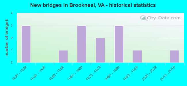
- New bridges - historical statistics
- 31930-1939
- 11950-1959
- 31960-1969
- 21970-1979
- 31980-1989
- 11990-1999
- 12010-2019

- Reconstructed bridges - Historical Statistics
- 11990-1999
- 22000-2009


- Bridge Condition - Deck
- 22.2%Very good
- 55.6%Good
- 11.1%Satisfactory
- 11.1%Fair

- Bridge Condition - Superstructure
- 33.3%Very good
- 55.6%Good
- 11.1%Satisfactory

- Bridge Condition - Channel
- 7.7%Very good
- 38.5%Good
- 30.8%Satisfactory
- 23.1%Fair

- Bridge Condition - Culverts
- 20.0%Good
- 60.0%Satisfactory
- 20.0%Fair
Find on map >> Show street view
Structure Number: 4163, Location: 0.00-CmpbCo./0.00-HlfxCo. (Lat: 37.037133, Lng: -78.945908), Route carried "on" structure: US 501, Year Built: 1989, Status: Open, Structure Length: 24.75m (81.20ft), Average Daily Traffic: 5,277 (year 2020), Truck Traffic: 9%, Average Future Daily Traffic: 5,805 (year 2040), Design Load: HS 20+Mod, Features Intersected: Staunton River, Facility Carried by Structure: L.P. Bailey Hwy.
Minimum Vertical Clearance: 30+ m (98+ ft), Kilometerpoint: 63.105, Lanes on structure: 2, Base Highway Network: Yes, Owner: State Highway Agency, Approaching Roadway Width: 9.8m (32.2ft), Material/Design: Prestressed concrete continuous, Design/Construction: Stringer/Multi-beam, Number Of Spans In Main Unit: 9, Length of Maximum Span: 27.7m (90.9ft), Curb-To-Curb Width: 14.2m (46.6ft), Out-to-Out Width: 15.2m (49.9ft)
Condition: Deck: Good, Superstructure: Good, Substructure: Good, Channel: Good, Operating Rating: 58.1 metric tons, Method Used To Determine Operating Rating: Load and Resistance Factor (LRFR), Inventory Rating: 44.5 metric tons, Method Used To Determine Inventory Rating: Load and Resistance Factor (LRFR), Structural Evaluation: Better than present minimum criteria, Deck Geometry: Superior to present desirable criteria, Waterway Adequacy: Equal to present desirable criteria, Approach Roadway Alignment: Equal to present desirable criteria, Designated Inspection Frequency: Every 24 months, Underwater Inspection Frequency: Every 60 months, Inspection Date: December 2020, Underwater Inspection Date: October 2021, Deck Structure Type: Concrete Cast-file-Place, Wearing Surface/Protective System: Deck Protection: Epoxy Coated Reinforcing
Find on map >> Show street view
Structure Number: 42, Location: 0.40-Rt 40 / 1.15-Rt 881 (Lat: 37.049200, Lng: -78.925939), Route carried "on" structure: County highway 600, Year Built: 1932, Status: Open, Structure Length: 0.66m (2.17ft), Average Daily Traffic: 270 (year 2020), Truck Traffic: 7%, Average Future Daily Traffic: 297 (year 2040), Features Intersected: Dog Creek, Facility Carried by Structure: Dog Creek Road
Minimum Vertical Clearance: 30+ m (98+ ft), Kilometerpoint: 0.697, Lanes on structure: 2, Owner: State Highway Agency, Approaching Roadway Width: 5.2m (17.1ft), Skew: 2 degrees, Material/Design: Concrete, Design/Construction: Culvert, Number Of Spans In Main Unit: 2, Length of Maximum Span: 3.2m (10.5ft)
Condition: Channel: Fair, Culverts: Fair, Operating Rating: 89.8 metric tons, Method Used To Determine Operating Rating: Load Factor (LF), Inventory Rating: 89.8 metric tons, Method Used To Determine Inventory Rating: Load Factor (LF), Structural Evaluation: Somewhat better than minimum adequacy, Waterway Adequacy: Better than present minimum criteria, Approach Roadway Alignment: Equal to present minimum criteria, Designated Inspection Frequency: Every 24 months, Inspection Date: April 2020
Find on map >> Show street view
Structure Number: 4206, Location: 0.95-Rt.786 / 0.80-Rt.633 (Lat: 37.069958, Lng: -79.023169), Route carried "on" structure: County highway 605, Year Built: 1932, Year Reconstructed: 2006, Status: Open, Structure Length: 1.58m (5.18ft), Average Daily Traffic: 549 (year 2020), Truck Traffic: 4%, Average Future Daily Traffic: 604 (year 2040), Design Load: H 15, Features Intersected: Whipping Creek, Facility Carried by Structure: Whipping Creek Rd
Minimum Vertical Clearance: 30+ m (98+ ft), Kilometerpoint: 1.287, Lanes on structure: 2, Owner: State Highway Agency, Approaching Roadway Width: 5.0m (16.4ft), Material/Design: Steel, Design/Construction: Stringer/Multi-beam, Number Of Spans In Main Unit: 1, Length of Maximum Span: 14.8m (48.6ft), Curb-To-Curb Width: 6.7m (22.0ft), Out-to-Out Width: 7.0m (23.0ft)
Condition: Deck: Very good, Superstructure: Very good, Substructure: Good, Channel: Satisfactory, Operating Rating: 45.4 metric tons, Method Used To Determine Operating Rating: Load and Resistance Factor (LRFR), Inventory Rating: 34.5 metric tons, Method Used To Determine Inventory Rating: Load and Resistance Factor (LRFR), Structural Evaluation: Better than present minimum criteria, Deck Geometry: Meets minimum limits, Waterway Adequacy: Better than present minimum criteria, Approach Roadway Alignment: Equal to present desirable criteria, Designated Inspection Frequency: Every 24 months, Inspection Date: January 2021, Deck Structure Type: Wood or Timber, Wearing Surface/Protective System: Wearing Surface: Bituminous
Find on map >> Show street view
Structure Number: 4207, Location: 1.00-Rt 601W/.20-Rt 601E (Lat: 37.083600, Lng: -78.936222), Route carried "on" structure: County highway 605, Year Built: 1989, Status: Open, Structure Length: 11.49m (37.70ft), Average Daily Traffic: 1,007 (year 2020), Truck Traffic: 4%, Average Future Daily Traffic: 1,108 (year 2040), Design Load: HS 20+Mod, Features Intersected: Falling River, Facility Carried by Structure: Swinging Bridge Rd
Minimum Vertical Clearance: 30+ m (98+ ft), Kilometerpoint: 12.856, Lanes on structure: 2, Owner: State Highway Agency, Approaching Roadway Width: 7.3m (24.0ft), Skew: 1 degrees, Material/Design: Steel, Design/Construction: Stringer/Multi-beam, Number Of Spans In Main Unit: 5, Length of Maximum Span: 22.9m (75.1ft), Curb-To-Curb Width: 8.7m (28.5ft), Out-to-Out Width: 9.7m (31.8ft)
Condition: Deck: Good, Superstructure: Good, Substructure: Good, Channel: Good, Operating Rating: 94.3 metric tons, Method Used To Determine Operating Rating: Load and Resistance Factor (LRFR), Inventory Rating: 72.6 metric tons, Method Used To Determine Inventory Rating: Load and Resistance Factor (LRFR), Structural Evaluation: Better than present minimum criteria, Deck Geometry: Somewhat better than minimum adequacy, Waterway Adequacy: Equal to present desirable criteria, Approach Roadway Alignment: Equal to present desirable criteria, Designated Inspection Frequency: Every 24 months, Inspection Date: October 2021, Deck Structure Type: Concrete Cast-file-Place, Wearing Surface/Protective System: Wearing Surface: Epoxy Overlay
Find on map >> Show street view
Structure Number: 4208, Location: .05-Rt 601/.75-Rt 602 (Lat: 37.083017, Lng: -78.933339), Route carried "on" structure: County highway 605, Year Built: 1989, Status: Open, Structure Length: 0.64m (2.10ft), Average Daily Traffic: 1,007 (year 2020), Truck Traffic: 4%, Average Future Daily Traffic: 1,108 (year 2040), Features Intersected: Hat Creek, Facility Carried by Structure: Swinging Bridge Rd
Minimum Vertical Clearance: 30+ m (98+ ft), Kilometerpoint: 13.178, Lanes on structure: 2, Owner: State Highway Agency, Approaching Roadway Width: 7.3m (24.0ft), Material/Design: Concrete, Design/Construction: Culvert, Number Of Spans In Main Unit: 2, Length of Maximum Span: 3.0m (9.8ft)
Condition: Channel: Fair, Culverts: Satisfactory, Operating Rating: 89.8 metric tons, Method Used To Determine Operating Rating: Load Factor (LF), Inventory Rating: 89.8 metric tons, Method Used To Determine Inventory Rating: Load Factor (LF), Structural Evaluation: Equal to present minimum criteria, Waterway Adequacy: Equal to present desirable criteria, Approach Roadway Alignment: Equal to present desirable criteria, Designated Inspection Frequency: Every 24 months, Inspection Date: October 2021
Find on map >> Show street view
Structure Number: 4214, Location: 0.17-Rt. 633/2.61-Rt. 635 (Lat: 37.055408, Lng: -79.007333), Route carried "on" structure: County highway 614, Year Built: 1932, Year Reconstructed: 2003, Status: Open, Structure Length: 1.00m (3.28ft), Average Daily Traffic: 67 (year 2019), Average Future Daily Traffic: 74 (year 2040), Features Intersected: Branch Whipping Creek, Facility Carried by Structure: McIver Ferry Rd.
Minimum Vertical Clearance: 30+ m (98+ ft), Kilometerpoint: 4.222, Lanes on structure: 2, Owner: State Highway Agency, Approaching Roadway Width: 4.9m (16.1ft), Material/Design: Steel, Design/Construction: Stringer/Multi-beam, Number Of Spans In Main Unit: 1, Length of Maximum Span: 8.8m (28.9ft), Curb-To-Curb Width: 6.8m (22.3ft), Out-to-Out Width: 7.0m (23.0ft)
Condition: Deck: Very good, Superstructure: Good, Substructure: Good, Channel: Very good, Operating Rating: 73.5 metric tons, Method Used To Determine Operating Rating: Load and Resistance Factor (LRFR), Inventory Rating: 56.2 metric tons, Method Used To Determine Inventory Rating: Load and Resistance Factor (LRFR), Structural Evaluation: Better than present minimum criteria, Deck Geometry: Somewhat better than minimum adequacy, Waterway Adequacy: Better than present minimum criteria, Approach Roadway Alignment: Better than present minimum criteria, Designated Inspection Frequency: Every 24 months, Inspection Date: Febuary 2021, Deck Structure Type: Wood or Timber, Wearing Surface/Protective System: Wearing Surface: Bituminous, Membrane: Preformed Fabric
Find on map >> Show street view
Structure Number: 4238, Location: 0.30-Rt 614/1.30-Rt 613 (Lat: 37.060794, Lng: -79.006494), Route carried "on" structure: County highway 633, Year Built: 1959, Year Reconstructed: 2011, Status: Open, Structure Length: 2.50m (8.20ft), Average Daily Traffic: 205 (year 2020), Truck Traffic: 6%, Average Future Daily Traffic: 226 (year 2040), Design Load: HS 20, Features Intersected: Whipping Creek, Facility Carried by Structure: Epsons Road
Minimum Vertical Clearance: 30+ m (98+ ft), Kilometerpoint: 15.511, Lanes on structure: 2, Owner: State Highway Agency, Approaching Roadway Width: 5.5m (18.0ft), Material/Design: Steel, Design/Construction: Stringer/Multi-beam, Number Of Spans In Main Unit: 2, Length of Maximum Span: 12.5m (41.0ft), Curb-To-Curb Width: 6.9m (22.6ft), Out-to-Out Width: 7.2m (23.6ft)
Condition: Deck: Good, Superstructure: Very good, Substructure: Good, Channel: Good, Operating Rating: 71.7 metric tons, Method Used To Determine Operating Rating: Load and Resistance Factor (LRFR), Inventory Rating: 55.3 metric tons, Method Used To Determine Inventory Rating: Load and Resistance Factor (LRFR), Structural Evaluation: Better than present minimum criteria, Deck Geometry: Meets minimum limits, Waterway Adequacy: Somewhat better than minimum adequacy, Approach Roadway Alignment: Equal to present desirable criteria, Length Of Structure Improvement: 3.11m (10.20ft), Designated Inspection Frequency: Every 24 months, Inspection Date: November 2021, Bridge Improvement Cost: $543,000, Roadway Improvement Cost: $54,000, Total Project Cost: $814,000 ( Estimate for 2014), Deck Structure Type: Wood or Timber, Wearing Surface/Protective System: Wearing Surface: Bituminous, Membrane: Preformed Fabric
Find on map >> Show street view
Structure Number: 4837, Location: 0.4 to 618-0.2 to Camp co (Lat: 37.075769, Lng: -78.876522), Route carried "on" structure: State highway 40, Year Built: 1974, Status: Open, Structure Length: 1.37m (4.49ft), Average Daily Traffic: 1,165 (year 2020), Truck Traffic: 20%, Average Future Daily Traffic: 1,282 (year 2040), Design Load: HS 20, Features Intersected: Turnip Creek, Facility Carried by Structure: Patrick Henry Hwy.
Minimum Vertical Clearance: 30+ m (98+ ft), Kilometerpoint: 156.237, Lanes on structure: 2, Owner: State Highway Agency, Approaching Roadway Width: 7.9m (25.9ft), Skew: 1 degrees, Material/Design: Concrete, Design/Construction: Culvert, Number Of Spans In Main Unit: 4, Length of Maximum Span: 3.0m (9.8ft)
Condition: Channel: Satisfactory, Culverts: Good, Operating Rating: 73.5 metric tons, Method Used To Determine Operating Rating: Load Factor (LF), Inventory Rating: 43.5 metric tons, Method Used To Determine Inventory Rating: Load Factor (LF), Structural Evaluation: Better than present minimum criteria, Waterway Adequacy: Better than present minimum criteria, Approach Roadway Alignment: Equal to present desirable criteria, Designated Inspection Frequency: Every 24 months, Inspection Date: November 2020
Find on map >> Show street view
Structure Number: 4895, Location: 1.70-Rt 620/1.40-Rt 677 (Lat: 37.030269, Lng: -78.881733), Route carried "on" structure: County highway 619, Year Built: 1969, Status: Open, Structure Length: 6.25m (20.51ft), Average Daily Traffic: 143 (year 2015), Average Future Daily Traffic: 161 (year 2040), Design Load: HS 20+Mod, Features Intersected: NS Railway, Facility Carried by Structure: Staunton Hill Road
Minimum Vertical Clearance: 30+ m (98+ ft), Kilometerpoint: 2.835, Lanes on structure: 2, Owner: State Highway Agency, Approaching Roadway Width: 5.5m (18.0ft), Skew: 1 degrees, Material/Design: Steel, Design/Construction: Stringer/Multi-beam, Number Of Spans In Main Unit: 3, Length of Maximum Span: 30.4m (99.7ft), Curb or Sidewalk Widths: Left: 0.2m (0.7ft), Right: 0.2m (0.7ft), Curb-To-Curb Width: 8.1m (26.6ft), Out-to-Out Width: 9.1m (29.9ft)
Condition: Deck: Satisfactory, Superstructure: Good, Substructure: Good, Operating Rating: 71.7 metric tons, Method Used To Determine Operating Rating: Load and Resistance Factor (LRFR), Inventory Rating: 55.3 metric tons, Method Used To Determine Inventory Rating: Load and Resistance Factor (LRFR), Structural Evaluation: Better than present minimum criteria, Deck Geometry: Somewhat better than minimum adequacy, Underclear: Meets minimum limits, Approach Roadway Alignment: Equal to present desirable criteria, Designated Inspection Frequency: Every 24 months, Inspection Date: August 2020, Deck Structure Type: Concrete Cast-file-Place, Wearing Surface/Protective System: Wearing Surface: Epoxy Overlay
Find on map >> Show street view
Structure Number: 921, Location: 0.12 to 636N-0.01 to 636S (Lat: 36.995097, Lng: -78.979228), Route carried "on" structure: US 501, Year Built: 1961, Status: Open, Structure Length: 1.79m (5.87ft), Average Daily Traffic: 2,885 (year 2020), Truck Traffic: 11%, Average Future Daily Traffic: 3,174 (year 2040), Design Load: HS 20, Features Intersected: Childrey Creek, Facility Carried by Structure: Huell Matthews Hwy
Minimum Vertical Clearance: 30+ m (98+ ft), Kilometerpoint: 57.380, Lanes on structure: 2, Base Highway Network: Yes, Owner: State Highway Agency, Approaching Roadway Width: 7.6m (24.9ft), Skew: 4 degrees, Material/Design: Concrete, Design/Construction: Culvert, Number Of Spans In Main Unit: 4, Length of Maximum Span: 4.3m (14.1ft)
Condition: Channel: Satisfactory, Culverts: Satisfactory, Operating Rating: 89.8 metric tons, Method Used To Determine Operating Rating: Load Factor (LF), Inventory Rating: 55.3 metric tons, Method Used To Determine Inventory Rating: Load Factor (LF), Structural Evaluation: Equal to present minimum criteria, Waterway Adequacy: Equal to present desirable criteria, Approach Roadway Alignment: Equal to present desirable criteria, Designated Inspection Frequency: Every 24 months, Inspection Date: January 2021
Find on map >> Show street view
Structure Number: 9246, Location: 2.52 TO 834 - 1.78 TO 634 (Lat: 37.008019, Lng: -78.922897), Route carried "on" structure: County highway 632, Year Built: 1963, Status: Open, Structure Length: 1.45m (4.76ft), Average Daily Traffic: 479 (year 2020), Truck Traffic: 5%, Average Future Daily Traffic: 557 (year 2040), Features Intersected: Childrey Creek, Facility Carried by Structure: Hog Wallow Road
Minimum Vertical Clearance: 30+ m (98+ ft), Kilometerpoint: 2.866, Lanes on structure: 2, Owner: State Highway Agency, Approaching Roadway Width: 6.1m (20.0ft), Material/Design: Steel, Design/Construction: Stringer/Multi-beam, Number Of Spans In Main Unit: 1, Length of Maximum Span: 13.4m (44.0ft), Curb or Sidewalk Widths: Left: 0.5m (1.6ft), Right: 0.5m (1.6ft), Curb-To-Curb Width: 7.3m (24.0ft), Out-to-Out Width: 8.2m (26.9ft)
Condition: Deck: Fair, Superstructure: Satisfactory, Substructure: Good, Channel: Fair, Operating Rating: 51.7 metric tons, Method Used To Determine Operating Rating: Load Factor (LF), Inventory Rating: 30.8 metric tons, Method Used To Determine Inventory Rating: Load Factor (LF), Structural Evaluation: Equal to present minimum criteria, Deck Geometry: Meets minimum limits, Waterway Adequacy: Equal to present minimum criteria, Approach Roadway Alignment: Equal to present desirable criteria, Designated Inspection Frequency: Every 24 months, Inspection Date: January 2021, Deck Structure Type: Concrete Cast-file-Place, Wearing Surface/Protective System: Wearing Surface: Monolithic Concrete
Find on map >> Show street view
Structure Number: 9249, Location: 1.54 TO 40 - 2.25 TO 639 (Lat: 37.026692, Lng: -79.019653), Route carried "on" structure: County highway 638, Year Built: 1973, Status: Open, Structure Length: 0.69m (2.26ft), Average Daily Traffic: 174 (year 2020), Average Future Daily Traffic: 244 (year 2040), Features Intersected: Bull Creek, Facility Carried by Structure: Bull Creek Road
Minimum Vertical Clearance: 30+ m (98+ ft), Kilometerpoint: 6.349, Lanes on structure: 2, Owner: State Highway Agency, Approaching Roadway Width: 5.8m (19.0ft), Skew: 2 degrees, Material/Design: Concrete, Design/Construction: Culvert, Number Of Spans In Main Unit: 2, Length of Maximum Span: 3.4m (11.2ft)
Condition: Channel: Satisfactory, Culverts: Satisfactory, Operating Rating: 89.8 metric tons, Method Used To Determine Operating Rating: Load Factor (LF), Inventory Rating: 89.8 metric tons, Method Used To Determine Inventory Rating: Load Factor (LF), Structural Evaluation: Equal to present minimum criteria, Waterway Adequacy: Better than present minimum criteria, Approach Roadway Alignment: Equal to present desirable criteria, Designated Inspection Frequency: Every 24 months, Inspection Date: October 2020
Find on map >> Show street view
Structure Number: 24609, Location: .06-E Brknl / 4.20-Cha Co (Lat: 37.053592, Lng: -78.935786), Route carried "on" structure: State highway 40, Year Built: 1996, Status: Open, Structure Length: 9.82m (32.22ft), Average Daily Traffic: 2,292 (year 2020), Truck Traffic: 20%, Average Future Daily Traffic: 2,521 (year 2040), Design Load: HS 20+Mod, Features Intersected: Falling River, Facility Carried by Structure: Wickliffe Avenue
Minimum Vertical Clearance: 30+ m (98+ ft), Kilometerpoint: 149.159, Lanes on structure: 2, Base Highway Network: Yes, Owner: State Highway Agency, Approaching Roadway Width: 12.2m (40.0ft), Skew: 2 degrees, Material/Design: Concrete, Design/Construction: Stringer/Multi-beam, Number Of Spans In Main Unit: 4, Length of Maximum Span: 23.7m (77.8ft), Curb-To-Curb Width: 13.4m (44.0ft), Out-to-Out Width: 14.4m (47.2ft)
Condition: Deck: Good, Superstructure: Good, Substructure: Good, Channel: Good, Operating Rating: 89.8 metric tons, Method Used To Determine Operating Rating: Load and Resistance Factor (LRFR), Inventory Rating: 89.8 metric tons, Method Used To Determine Inventory Rating: Load and Resistance Factor (LRFR), Structural Evaluation: Better than present minimum criteria, Deck Geometry: Better than present minimum criteria, Waterway Adequacy: Equal to present desirable criteria, Approach Roadway Alignment: Equal to present desirable criteria, Designated Inspection Frequency: Every 24 months, Inspection Date: April 2020, Deck Structure Type: Concrete Cast-file-Place
Find on map >> Show street view
Structure Number: 28932, Location: 0.6-Rt. 641/1.2-Rt. 642 (Lat: 37.126600, Lng: -78.959900), Route carried "on" structure: County highway 643, Year Built: 2016, Status: Open, Structure Length: 8.84m (29.00ft), Average Daily Traffic: 348 (year 2020), Truck Traffic: 3%, Average Future Daily Traffic: 383 (year 2040), Design Load: HL 93, Features Intersected: Falling River, Facility Carried by Structure: Lewis Ford Rd.
Minimum Vertical Clearance: 30+ m (98+ ft), Kilometerpoint: 0.000, Lanes on structure: 2, Owner: State Highway Agency, Approaching Roadway Width: 8.2m (26.9ft), Skew: 4 degrees, Material/Design: Steel continuous, Design/Construction: Stringer/Multi-beam, Number Of Spans In Main Unit: 3, Length of Maximum Span: 36.6m (120.1ft), Curb-To-Curb Width: 8.5m (27.9ft), Out-to-Out Width: 9.2m (30.2ft)
Condition: Deck: Good, Superstructure: Very good, Substructure: Good, Channel: Good, Operating Rating: 66.2 metric tons, Method Used To Determine Operating Rating: Load and Resistance Factor (LRFR), Inventory Rating: 50.8 metric tons, Method Used To Determine Inventory Rating: Load and Resistance Factor (LRFR), Structural Evaluation: Better than present minimum criteria, Deck Geometry: Equal to present minimum criteria, Waterway Adequacy: Somewhat better than minimum adequacy, Approach Roadway Alignment: Equal to present minimum criteria, Designated Inspection Frequency: Every 24 months, Inspection Date: January 2022, Deck Structure Type: Concrete Cast-file-Place