Bridge Statistics for Brooklyn, Connecticut (CT)
Condition, Traffic, Stress, Structural Evaluation, Project Costs
- National Bridge Inventory (NBI) Statistics
- 10Number of bridges
- 95ft / 29.0mTotal length
- 85,935Total average daily traffic
- 5,910Total average daily truck traffic
- 127,691Total future (year 2036) average daily traffic
- National Bridge Inventory (NBI) Registered Bridges for Brooklyn
- No street view available for this location
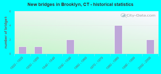
- New bridges - historical statistics
- 11920-1929
- 11930-1939
- 21950-1959
- 41980-1989
- 22000-2009

- Reconstructed bridges - Historical Statistics
- 31980-1989
- 11990-1999
- 12000-2009
- 12010-2019


- Bridge Condition - Deck
- 50.0%Very good
- 12.5%Good
- 37.5%Satisfactory

- Bridge Condition - Superstructure
- 50.0%Very good
- 12.5%Satisfactory
- 37.5%Fair

- Bridge Condition - Substructure
- 37.5%Good
- 62.5%Satisfactory

- Bridge Condition - Channel
- 11.1%Very good
- 22.2%Good
- 44.4%Satisfactory
- 22.2%Fair
Find on map >> Show street view
Structure Number: 575, Location: 0.6 MI N OF ROUTE 34 (Lat: 41.327539, Lng: -73.085942), Route carried "on" structure: State highway 8, Year Built: 1951, Year Reconstructed: 1990, Status: Open, Structure Length: 5.18m (16.99ft), Average Daily Traffic: 64,000 (year 2018), Truck Traffic: 8%, Average Future Daily Traffic: 95,098 (year 2038), Design Load: HS 20, Features Intersected: SR 727 SB PERSHING DRIVE
Minimum Vertical Clearance: 30+ m (98+ ft), Kilometerpoint: 21.549, Lanes on structure: 4, Lanes under structure: 1, Base Highway Network: Yes, Owner: State Highway Agency, Approaching Roadway Width: 22.3m (73.2ft), Skew: 34 degrees, Material/Design: Steel continuous, Design/Construction: Stringer/Multi-beam, Number Of Spans In Main Unit: 3, Length of Maximum Span: 20.4m (66.9ft), Curb-To-Curb Width: 22.2m (72.8ft), Out-to-Out Width: 24.3m (79.7ft)
Condition: Deck: Good, Superstructure: Fair, Substructure: Satisfactory, Operating Rating: 62.2 metric tons, Method Used To Determine Operating Rating: Load and Resistance Factor Rating (LRFR) rating reported by rating factor(RF) method using HL-93 loadings, Inventory Rating: 48.0 metric tons, Method Used To Determine Inventory Rating: Load and Resistance Factor Rating (LRFR) rating reported by rating factor(RF) method using HL-93 loadings, Structural Evaluation: Somewhat better than minimum adequacy, Deck Geometry: Superior to present desirable criteria, Underclear: Somewhat better than minimum adequacy, Approach Roadway Alignment: Equal to present desirable criteria, Designated Inspection Frequency: Every 24 months, Inspection Date: September 2021, Deck Structure Type: Concrete Cast-file-Place, Wearing Surface/Protective System: Wearing Surface: Bituminous, Membrane: Built-up, Deck Protection: Epoxy Coated Reinforcing
Find on map >> Show street view
Structure Number: 1419, Location: 5 MILES NORTH OF ROUTE 14 (Lat: 41.765069, Lng: -71.956561), Route carried "on" structure: State highway 169, Year Built: 1927, Year Reconstructed: 1987, Status: Open, Structure Length: 1.34m (4.40ft), Average Daily Traffic: 2,100 (year 2016), Truck Traffic: 3%, Average Future Daily Traffic: 3,120 (year 2036), Design Load: HS 15, Features Intersected: BLACKWELL BROOK
Minimum Vertical Clearance: 30+ m (98+ ft), Kilometerpoint: 30.465, Lanes on structure: 2, Owner: State Highway Agency, Approaching Roadway Width: 7.9m (25.9ft), Material/Design: Concrete, Design/Construction: Tee Beam, Number Of Spans In Main Unit: 1, Length of Maximum Span: 11.6m (38.1ft), Curb-To-Curb Width: 8.6m (28.2ft), Out-to-Out Width: 9.4m (30.8ft)
Condition: Deck: Satisfactory, Superstructure: Satisfactory, Substructure: Satisfactory, Channel: Fair, Operating Rating: 83.4 metric tons, Method Used To Determine Operating Rating: Load Factor (LF), Inventory Rating: 45.3 metric tons, Method Used To Determine Inventory Rating: Load Factor (LF), Structural Evaluation: Equal to present minimum criteria, Deck Geometry: Meets minimum limits, Waterway Adequacy: Better than present minimum criteria, Approach Roadway Alignment: Equal to present desirable criteria, Designated Inspection Frequency: Every 24 months, Inspection Date: August 2021, Deck Structure Type: Concrete Cast-file-Place, Wearing Surface/Protective System: Wearing Surface: Bituminous, Membrane: Preformed Fabric
Find on map >> Show street view
Structure Number: 1543, Location: .5 MILE NORTH OF ROUTE 12 (Lat: 41.747478, Lng: -71.914767), Route carried "on" structure: State highway 205, Year Built: 1959, Year Reconstructed: 1988, Status: Open, Structure Length: 13.41m (44.00ft), Average Daily Traffic: 4,600 (year 2016), Truck Traffic: 3%, Average Future Daily Traffic: 6,835 (year 2036), Design Load: HS 20, Features Intersected: QUINEBAUG RIVER & CANAL
Minimum Vertical Clearance: 30+ m (98+ ft), Kilometerpoint: 0.772, Lanes on structure: 2, Owner: State Highway Agency, Approaching Roadway Width: 12.2m (40.0ft), Skew: 1 degrees, Material/Design: Steel, Design/Construction: Stringer/Multi-beam, Number Of Spans In Main Unit: 6, Length of Maximum Span: 22.4m (73.5ft), Curb or Sidewalk Widths: Left: 1.7m (5.6ft), Right: 1.7m (5.6ft), Curb-To-Curb Width: 12.2m (40.0ft), Out-to-Out Width: 16.3m (53.5ft)
Condition: Deck: Satisfactory, Superstructure: Fair, Substructure: Satisfactory, Channel: Satisfactory, Operating Rating: 68.9 metric tons, Method Used To Determine Operating Rating: Load Factor (LF), Inventory Rating: 40.8 metric tons, Method Used To Determine Inventory Rating: Load Factor (LF), Structural Evaluation: Somewhat better than minimum adequacy, Deck Geometry: Equal to present minimum criteria, Waterway Adequacy: Somewhat better than minimum adequacy, Approach Roadway Alignment: Equal to present desirable criteria, Designated Inspection Frequency: Every 24 months, Underwater Inspection Frequency: Every 24 months, Inspection Date: January 2022, Underwater Inspection Date: January 2022, Deck Structure Type: Concrete Cast-file-Place, Wearing Surface/Protective System: Wearing Surface: Bituminous, Membrane: Preformed Fabric, Deck Protection: Epoxy Coated Reinforcing
Find on map >> Show street view
Structure Number: 1546, Location: 2 MILES EAST OF HEBRON TL (Lat: 41.629853, Lng: -72.299033), Route carried "on" structure: State highway 207, Year Built: 1935, Year Reconstructed: 1986, Status: Open, Structure Length: 1.10m (3.61ft), Average Daily Traffic: 2,200 (year 2018), Truck Traffic: 2%, Average Future Daily Traffic: 3,269 (year 2038), Design Load: H 20, Features Intersected: CABIN BROOK
Minimum Vertical Clearance: 30+ m (98+ ft), Kilometerpoint: 4.410, Lanes on structure: 2, Base Highway Network: Yes, Owner: State Highway Agency, Approaching Roadway Width: 8.2m (26.9ft), Skew: 4 degrees, Material/Design: Concrete, Design/Construction: Tee Beam, Number Of Spans In Main Unit: 1, Length of Maximum Span: 10.1m (33.1ft), Curb-To-Curb Width: 8.6m (28.2ft), Out-to-Out Width: 10.1m (33.1ft)
Condition: Deck: Satisfactory, Superstructure: Fair, Substructure: Satisfactory, Channel: Satisfactory, Operating Rating: 73.5 metric tons, Method Used To Determine Operating Rating: Load Factor (LF), Inventory Rating: 43.5 metric tons, Method Used To Determine Inventory Rating: Load Factor (LF), Structural Evaluation: Somewhat better than minimum adequacy, Deck Geometry: Meets minimum limits, Waterway Adequacy: Equal to present minimum criteria, Approach Roadway Alignment: Equal to present desirable criteria, Designated Inspection Frequency: Every 24 months, Inspection Date: September 2021, Deck Structure Type: Concrete Cast-file-Place, Wearing Surface/Protective System: Wearing Surface: Bituminous, Membrane: Preformed Fabric
Find on map >> Show street view
Structure Number: 4595, Location: 100 FT E JCT MASON ROAD (Lat: 41.781731, Lng: -71.962267), Route carried "on" structure: City street , Year Built: 2000, Status: Open, Structure Length: 2.10m (6.89ft), Average Daily Traffic: 1,281 (year 2018), Truck Traffic: 7%, Average Future Daily Traffic: 1,903 (year 2038), Design Load: HS 20, Features Intersected: STONY BROOK, Facility Carried by Structure: TATNIC ROAD
Minimum Vertical Clearance: 30+ m (98+ ft), Kilometerpoint: 2.784, Lanes on structure: 2, Owner: Town or Township Highway Agency, Approaching Roadway Width: 9.1m (29.9ft), Skew: 2 degrees, Material/Design: Steel, Design/Construction: Stringer/Multi-beam, Number Of Spans In Main Unit: 3, Length of Maximum Span: 8.8m (28.9ft), Curb-To-Curb Width: 9.1m (29.9ft), Out-to-Out Width: 10.3m (33.8ft)
Condition: Deck: Very good, Superstructure: Very good, Substructure: Good, Channel: Good, Operating Rating: 90.4 metric tons, Method Used To Determine Operating Rating: Load and Resistance Factor Rating (LRFR) rating reported by rating factor(RF) method using HL-93 loadings, Inventory Rating: 69.7 metric tons, Method Used To Determine Inventory Rating: Load and Resistance Factor Rating (LRFR) rating reported by rating factor(RF) method using HL-93 loadings, Structural Evaluation: Better than present minimum criteria, Deck Geometry: Somewhat better than minimum adequacy, Waterway Adequacy: Equal to present desirable criteria, Approach Roadway Alignment: Equal to present desirable criteria, Designated Inspection Frequency: Every 24 months, Inspection Date: Febuary 2021, Deck Structure Type: Concrete Cast-file-Place, Wearing Surface/Protective System: Wearing Surface: Bituminous, Membrane: Preformed Fabric, Deck Protection: Epoxy Coated Reinforcing
Find on map >> Show street view
Structure Number: 4597, Location: .4 MI E OF ROUTE 169 (Lat: 41.757194, Lng: -71.951786), Route carried "on" structure: City street , Year Built: 2000, Status: Open, Structure Length: 1.80m (5.91ft), Average Daily Traffic: 1,102 (year 2019), Truck Traffic: 7%, Average Future Daily Traffic: 1,637 (year 2039), Design Load: HS 20, Features Intersected: BLACKWELL BROOK, Facility Carried by Structure: BEECHER ROAD
Minimum Vertical Clearance: 30+ m (98+ ft), Kilometerpoint: 0.966, Lanes on structure: 2, Owner: Town or Township Highway Agency, Approaching Roadway Width: 6.7m (22.0ft), Skew: 2 degrees, Material/Design: Prestressed concrete, Design/Construction: Box Beam or Girders - Multiple, Number Of Spans In Main Unit: 1, Length of Maximum Span: 16.5m (54.1ft), Curb-To-Curb Width: 6.6m (21.7ft), Out-to-Out Width: 7.5m (24.6ft)
Condition: Deck: Very good, Superstructure: Very good, Substructure: Good, Channel: Good, Operating Rating: 42.6 metric tons, Method Used To Determine Operating Rating: Field evaluation and documented engineering judgment, Inventory Rating: 32.7 metric tons, Method Used To Determine Inventory Rating: Field evaluation and documented engineering judgment, Structural Evaluation: Better than present minimum criteria, Deck Geometry: High priority of replacement, Waterway Adequacy: Equal to present desirable criteria, Approach Roadway Alignment: Equal to present minimum criteria, Designated Inspection Frequency: Every 24 months, Inspection Date: Febuary 2021, Deck Structure Type: Other, Wearing Surface/Protective System: Wearing Surface: Bituminous, Membrane: Preformed Fabric, Deck Protection: Epoxy Coated Reinforcing
Find on map >> Show street view
Structure Number: 5336, Location: 1.5 MILES WEST OF RTE 169 (Lat: 41.803542, Lng: -71.981003), Route carried "on" structure: City street , Year Built: 1985, Status: Open, Structure Length: 0.76m (2.49ft), Average Daily Traffic: 584 (year 2019), Truck Traffic: 7%, Average Future Daily Traffic: 868 (year 2039), Features Intersected: BLACKWELL BROOK, Facility Carried by Structure: WOODWARD ROAD
Minimum Vertical Clearance: 30+ m (98+ ft), Kilometerpoint: 1.159, Lanes on structure: 2, Owner: Town or Township Highway Agency, Approaching Roadway Width: 7.3m (24.0ft), Material/Design: Aluminum, Iron, Design/Construction: Culvert, Number Of Spans In Main Unit: 1, Length of Maximum Span: 7.6m (24.9ft), Curb-To-Curb Width: 7.2m (23.6ft), Out-to-Out Width: 8.0m (26.2ft)
Condition: Channel: Satisfactory, Culverts: Satisfactory, Operating Rating: 69.3 metric tons, Method Used To Determine Operating Rating: Load and Resistance Factor Rating (LRFR) rating reported by rating factor(RF) method using HL-93 loadings, Inventory Rating: 53.5 metric tons, Method Used To Determine Inventory Rating: Load and Resistance Factor Rating (LRFR) rating reported by rating factor(RF) method using HL-93 loadings, Structural Evaluation: Equal to present minimum criteria, Deck Geometry: Meets minimum limits, Waterway Adequacy: Equal to present desirable criteria, Approach Roadway Alignment: Equal to present desirable criteria, Designated Inspection Frequency: Every 24 months, Inspection Date: Febuary 2021
Find on map >> Show street view
Structure Number: 5377, Location: .5 MILES NORTH OF ROUTE 6 (Lat: 41.798025, Lng: -71.981875), Route carried "on" structure: City street , Year Built: 1986, Year Reconstructed: 2010, Status: Open, Structure Length: 0.82m (2.69ft), Average Daily Traffic: 440 (year 2019), Truck Traffic: 7%, Average Future Daily Traffic: 654 (year 2039), Design Load: HL 93, Features Intersected: BLACKWELL BROOK, Facility Carried by Structure: FITZGERALD ROAD
Minimum Vertical Clearance: 3.84m (12.60ft), Kilometerpoint: 7.339, Lanes on structure: 1, Owner: Town or Township Highway Agency, Approaching Roadway Width: 5.5m (18.0ft), Material/Design: Wood or Timber, Design/Construction: Stringer/Multi-beam, Number Of Spans In Main Unit: 1, Length of Maximum Span: 7.9m (25.9ft), Curb-To-Curb Width: 4.2m (13.8ft), Out-to-Out Width: 4.8m (15.7ft)
Condition: Deck: Very good, Superstructure: Very good, Substructure: Satisfactory, Channel: Satisfactory, Operating Rating: 37.9 metric tons, Method Used To Determine Operating Rating: Load and Resistance Factor Rating (LRFR) rating reported by rating factor(RF) method using HL-93 loadings, Inventory Rating: 29.2 metric tons, Method Used To Determine Inventory Rating: Load and Resistance Factor Rating (LRFR) rating reported by rating factor(RF) method using HL-93 loadings, Structural Evaluation: Equal to present minimum criteria, Deck Geometry: High priority of replacement, Waterway Adequacy: Equal to present desirable criteria, Approach Roadway Alignment: Equal to present minimum criteria, Designated Inspection Frequency: Every 24 months, Inspection Date: Febuary 2021, Deck Structure Type: Wood or Timber, Wearing Surface/Protective System: Wearing Surface: Wood or Timber
Find on map >> Show street view
Structure Number: 5394, Location: 1 MILE WEST OF ROUTE 169 (Lat: 41.784075, Lng: -71.963094), Route carried "on" structure: US 6, Year Built: 1985, Year Reconstructed: 2006, Status: Open, Structure Length: 1.68m (5.51ft), Average Daily Traffic: 9,100 (year 2016), Truck Traffic: 3%, Average Future Daily Traffic: 13,522 (year 2036), Design Load: HS 20, Features Intersected: BLACKWELL BROOK
Minimum Vertical Clearance: 30+ m (98+ ft), Kilometerpoint: 171.910, Lanes on structure: 2, Base Highway Network: Yes, Owner: State Highway Agency, Approaching Roadway Width: 12.2m (40.0ft), Material/Design: Prestressed concrete, Design/Construction: Box Beam or Girders - Multiple, Number Of Spans In Main Unit: 1, Length of Maximum Span: 16.2m (53.1ft), Curb or Sidewalk Widths: Left: 0.0m, Right: 1.7m (5.6ft), Curb-To-Curb Width: 12.2m (40.0ft), Out-to-Out Width: 14.8m (48.6ft)
Condition: Deck: Very good, Superstructure: Very good, Substructure: Good, Channel: Very good, Operating Rating: 76.6 metric tons, Method Used To Determine Operating Rating: Load Factor (LF), Inventory Rating: 45.9 metric tons, Method Used To Determine Inventory Rating: Load Factor (LF), Structural Evaluation: Better than present minimum criteria, Deck Geometry: Somewhat better than minimum adequacy, Waterway Adequacy: Equal to present desirable criteria, Approach Roadway Alignment: Equal to present desirable criteria, Designated Inspection Frequency: Every 48 months, Inspection Date: March 2021, Deck Structure Type: Other, Wearing Surface/Protective System: Wearing Surface: Bituminous, Membrane: Preformed Fabric
Find on map >> Show street view
Structure Number: 575, Location: 1 MI NORTH OF US ROUTE 6 (Lat: 41.793981, Lng: -71.977881), Route carried "on" structure: City street , Year Built: 1987, Status: Open, Structure Length: 0.79m (2.59ft), Average Daily Traffic: 528 (year 2021), Truck Traffic: 7%, Average Future Daily Traffic: 785 (year 2041), Features Intersected: BLACKWELL BROOK, Facility Carried by Structure: LAUREL HILL ROAD
Minimum Vertical Clearance: 30+ m (98+ ft), Kilometerpoint: 31.640, Lanes on structure: 2, Owner: Town or Township Highway Agency, Approaching Roadway Width: 9.1m (29.9ft), Skew: 3 degrees, Material/Design: Concrete, Design/Construction: Culvert, Number Of Spans In Main Unit: 2, Length of Maximum Span: 3.7m (12.1ft), Curb-To-Curb Width: 9.1m (29.9ft), Out-to-Out Width: 10.7m (35.1ft)
Condition: Channel: Fair, Culverts: Satisfactory, Operating Rating: 42.6 metric tons, Method Used To Determine Operating Rating: Field evaluation and documented engineering judgment, Inventory Rating: 32.7 metric tons, Method Used To Determine Inventory Rating: Field evaluation and documented engineering judgment, Structural Evaluation: Equal to present minimum criteria, Deck Geometry: Equal to present minimum criteria, Waterway Adequacy: Equal to present desirable criteria, Approach Roadway Alignment: Equal to present desirable criteria, Designated Inspection Frequency: Every 24 months, Inspection Date: Febuary 2021