Bridge Statistics for Brookeville, Maryland (MD)
Condition, Traffic, Stress, Structural Evaluation, Project Costs
- National Bridge Inventory (NBI) Statistics
- 13Number of bridges
- 69ft / 20.7mTotal length
- $243,000Total costs
- 53,437Total average daily traffic
- 3,469Total average daily truck traffic
- 61,601Total future (year 2026) average daily traffic
- National Bridge Inventory (NBI) Registered Bridges for Brookeville
- No street view available for this location
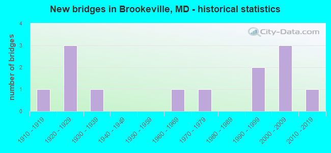
- New bridges - historical statistics
- 11910-1919
- 31920-1929
- 11930-1939
- 11960-1969
- 11970-1979
- 21990-1999
- 32000-2009
- 12010-2019

- Reconstructed bridges - Historical Statistics
- 21970-1979
- 11980-1989


- Bridge Condition - Deck
- 44.4%Good
- 33.3%Satisfactory
- 22.2%Fair

- Bridge Condition - Superstructure
- 33.3%Good
- 16.7%Satisfactory
- 50.0%Fair

- Bridge Condition - Substructure
- 8.3%Very good
- 33.3%Good
- 50.0%Satisfactory
- 8.3%Fair

- Bridge Condition - Channel
- 7.7%Very good
- 38.5%Good
- 38.5%Satisfactory
- 15.4%Fair
Find on map >> Show street view
Structure Number: 10000013003801, Location: ON MONTGOMERY CO LINE (Lat: 39.237928, Lng: -77.055850), Route carried "on" structure: State highway 97, Year Built: 2000, Status: Open, Structure Length: 6.89m (22.60ft), Average Daily Traffic: 13,200 (year 2009), Truck Traffic: 8%, Average Future Daily Traffic: 14,493 (year 2026), Design Load: HS 25 or greater, Features Intersected: PATUXENT RIVER
Minimum Vertical Clearance: 30+ m (98+ ft), Kilometerpoint: 0.000, Lanes on structure: 2, Base Highway Network: Yes, Owner: State Highway Agency, Approaching Roadway Width: 12.2m (40.0ft), Skew: 3 degrees, Material/Design: Steel continuous, Design/Construction: Stringer/Multi-beam, Number Of Spans In Main Unit: 2, Length of Maximum Span: 33.5m (109.9ft), Curb-To-Curb Width: 12.5m (41.0ft), Out-to-Out Width: 13.4m (44.0ft)
Condition: Deck: Good, Superstructure: Good, Substructure: Good, Channel: Very good, Inventory Rating: 73.5 metric tons, Method Used To Determine Inventory Rating: Load Factor (LF), Structural Evaluation: Better than present minimum criteria, Deck Geometry: Somewhat better than minimum adequacy, Waterway Adequacy: Superior to present desirable criteria, Approach Roadway Alignment: Equal to present desirable criteria, Designated Inspection Frequency: Every 24 months, Inspection Date: May 2021, Deck Structure Type: Concrete Cast-file-Place, Wearing Surface/Protective System: Wearing Surface: Integral Concrete, Deck Protection: Epoxy Coated Reinforcing
Find on map >> Show street view
Structure Number: 10000015001101, Location: 0.88 MILE SOUTH OF MD 650 (Lat: 39.209344, Lng: -77.062678), Route carried "on" structure: State highway 97, Year Built: 1930, Status: Open, Structure Length: 1.01m (3.31ft), Average Daily Traffic: 10,740 (year 2009), Truck Traffic: 8%, Average Future Daily Traffic: 11,244 (year 2026), Features Intersected: HAWLINGS RIVER
Minimum Vertical Clearance: 30+ m (98+ ft), Kilometerpoint: 25.979, Lanes on structure: 2, Base Highway Network: Yes, Owner: State Highway Agency, Approaching Roadway Width: 6.7m (22.0ft), Material/Design: Concrete, Design/Construction: Tee Beam, Number Of Spans In Main Unit: 1, Length of Maximum Span: 9.1m (29.9ft), Curb-To-Curb Width: 7.3m (24.0ft), Out-to-Out Width: 8.3m (27.2ft)
Condition: Deck: Fair, Superstructure: Fair, Substructure: Satisfactory, Channel: Satisfactory, Operating Rating: 51.2 metric tons, Method Used To Determine Operating Rating: Load Factor (LF), Inventory Rating: 30.8 metric tons, Method Used To Determine Inventory Rating: Load Factor (LF), Structural Evaluation: Somewhat better than minimum adequacy, Deck Geometry: High priority of replacement, Waterway Adequacy: Superior to present desirable criteria, Approach Roadway Alignment: Equal to present minimum criteria, Length Of Structure Improvement: 1.01m (3.31ft), Designated Inspection Frequency: Every 12 months, Inspection Date: March 2021, Bridge Improvement Cost: $54,000, Roadway Improvement Cost: $5,000, Total Project Cost: $59,000, Deck Structure Type: Concrete Cast-file-Place, Wearing Surface/Protective System: Wearing Surface: Monolithic Concrete
Find on map >> Show street view
Structure Number: 10000015001201, Location: 2.89 MILES S OF MD 650 (Lat: 39.181558, Lng: -77.061756), Route carried "on" structure: State highway 97, Year Built: 1927, Status: Open, Structure Length: 0.82m (2.69ft), Average Daily Traffic: 10,740 (year 2009), Truck Traffic: 8%, Average Future Daily Traffic: 11,244 (year 2026), Features Intersected: REDDY BRANCH
Minimum Vertical Clearance: 30+ m (98+ ft), Kilometerpoint: 22.716, Lanes on structure: 2, Base Highway Network: Yes, Owner: State Highway Agency, Approaching Roadway Width: 6.7m (22.0ft), Material/Design: Concrete, Design/Construction: Tee Beam, Number Of Spans In Main Unit: 1, Length of Maximum Span: 7.3m (24.0ft), Curb-To-Curb Width: 7.3m (24.0ft), Out-to-Out Width: 8.3m (27.2ft)
Condition: Deck: Satisfactory, Superstructure: Fair, Substructure: Satisfactory, Channel: Satisfactory, Operating Rating: 46.3 metric tons, Method Used To Determine Operating Rating: Load Factor (LF), Inventory Rating: 27.7 metric tons, Method Used To Determine Inventory Rating: Load Factor (LF), Structural Evaluation: Somewhat better than minimum adequacy, Deck Geometry: High priority of replacement, Waterway Adequacy: Equal to present minimum criteria, Approach Roadway Alignment: Equal to present desirable criteria, Length Of Structure Improvement: 0.82m (2.69ft), Designated Inspection Frequency: Every 12 months, Inspection Date: March 2021, Bridge Improvement Cost: $44,000, Roadway Improvement Cost: $4,000, Total Project Cost: $48,000, Deck Structure Type: Concrete Cast-file-Place, Wearing Surface/Protective System: Wearing Surface: Bituminous
Find on map >> Show street view
Structure Number: 200000M-009601, Location: 0.4 MILES WEST OF MD 650 (Lat: 39.176292, Lng: -77.031603), Route carried "on" structure: County highway 3937, Year Built: 2019, Status: Open, Structure Length: 1.77m (5.81ft), Average Daily Traffic: 2,901 (year 2021), Truck Traffic: 3%, Average Future Daily Traffic: 4,182 (year 2041), Features Intersected: HAWLINGS RIVER, Facility Carried by Structure: GOLD MINE ROAD
Minimum Vertical Clearance: 30+ m (98+ ft), Kilometerpoint: 2.655, Lanes on structure: 2, Owner: County Highway Agency, Approaching Roadway Width: 9.8m (32.2ft), Material/Design: Prestressed concrete, Design/Construction: Slab, Number Of Spans In Main Unit: 1, Length of Maximum Span: 16.8m (55.1ft), Curb or Sidewalk Widths: Left: 0.0m, Right: 2.4m (7.9ft), Curb-To-Curb Width: 1.0m (3.3ft), Out-to-Out Width: 13.8m (45.3ft)
Condition: Deck: Good, Superstructure: Good, Substructure: Very good, Channel: Good, Operating Rating: 87.8 metric tons, Method Used To Determine Operating Rating: Load and Resistance Factor Rating (LRFR) rating reported by rating factor(RF) method using HL-93 loadings, Inventory Rating: 67.7 metric tons, Method Used To Determine Inventory Rating: Load and Resistance Factor Rating (LRFR) rating reported by rating factor(RF) method using HL-93 loadings, Structural Evaluation: Better than present minimum criteria, Deck Geometry: High priority of replacement, Waterway Adequacy: Better than present minimum criteria, Approach Roadway Alignment: Better than present minimum criteria, Designated Inspection Frequency: Every 24 months, Inspection Date: October 2021, Deck Structure Type: Concrete Cast-file-Place, Wearing Surface/Protective System: Wearing Surface: Integral Concrete, Deck Protection: Epoxy Coated Reinforcing
Find on map >> Show street view
Structure Number: 200000M-009801, Location: 0.8 MI EAST OF MD 650 (Lat: 39.175883, Lng: -77.007692), Route carried "on" structure: County highway 67, Year Built: 1926, Status: Open, Structure Length: 1.22m (4.00ft), Average Daily Traffic: 888 (year 2019), Truck Traffic: 4%, Average Future Daily Traffic: 1,235 (year 2041), Features Intersected: HAWLINGS RIVER, Facility Carried by Structure: HAVILAND MILL ROAD
Minimum Vertical Clearance: 30+ m (98+ ft), Kilometerpoint: 1.287, Lanes on structure: 2, Owner: County Highway Agency, Approaching Roadway Width: 5.5m (18.0ft), Material/Design: Concrete, Design/Construction: Arch - Deck, Number Of Spans In Main Unit: 1, Length of Maximum Span: 12.2m (40.0ft), Curb-To-Curb Width: 5.0m (16.4ft), Out-to-Out Width: 5.5m (18.0ft)
Condition: Superstructure: Fair, Substructure: Satisfactory, Channel: Good, Operating Rating: 32.7 metric tons, Method Used To Determine Operating Rating: Field evaluation and documented engineering judgment, Inventory Rating: 32.7 metric tons, Method Used To Determine Inventory Rating: Field evaluation and documented engineering judgment, Structural Evaluation: Somewhat better than minimum adequacy, Deck Geometry: High priority of replacement, Waterway Adequacy: Equal to present minimum criteria, Approach Roadway Alignment: Equal to present minimum criteria, Length Of Structure Improvement: 1.22m (4.00ft), Designated Inspection Frequency: Every 24 months, Inspection Date: July 2020, Bridge Improvement Cost: $40,000, Roadway Improvement Cost: $4,000, Total Project Cost: $44,000
Find on map >> Show street view
Structure Number: 200000M-010801, Location: 0.9 MI W OF JCT SR MD 650 (Lat: 39.193350, Lng: -77.040983), Route carried "on" structure: County highway 57, Year Built: 1920, Year Reconstructed: 1975, Status: Open, Structure Length: 1.04m (3.41ft), Average Daily Traffic: 3,080 (year 2020), Truck Traffic: 3%, Average Future Daily Traffic: 4,157 (year 2040), Design Load: H 20, Features Intersected: HAWLINGS RIVER, Facility Carried by Structure: BRIGHTON DAM ROAD
Minimum Vertical Clearance: 30+ m (98+ ft), Kilometerpoint: 2.365, Lanes on structure: 1, Owner: County Highway Agency, Approaching Roadway Width: 6.1m (20.0ft), Material/Design: Steel, Design/Construction: Stringer/Multi-beam, Number Of Spans In Main Unit: 1, Length of Maximum Span: 8.5m (27.9ft), Curb-To-Curb Width: 7.2m (23.6ft), Out-to-Out Width: 7.3m (24.0ft)
Condition: Deck: Good, Superstructure: Fair, Substructure: Fair, Channel: Fair, Inventory Rating: 83.0 metric tons, Method Used To Determine Inventory Rating: Load Factor (LF), Structural Evaluation: Somewhat better than minimum adequacy, Deck Geometry: High priority of replacement, Waterway Adequacy: High priority of corrective action, Approach Roadway Alignment: Equal to present desirable criteria, Designated Inspection Frequency: Every 24 months, Inspection Date: October 2020, Deck Structure Type: Corrugated Steel, Wearing Surface/Protective System: Wearing Surface: Bituminous
Find on map >> Show street view
Structure Number: 200000M-011701, Location: 0.9 MI E OF JCT SR 97 (Lat: 39.184397, Lng: -77.046050), Route carried "on" structure: County highway 57, Year Built: 1910, Year Reconstructed: 1975, Status: Open, Structure Length: 0.85m (2.79ft), Average Daily Traffic: 3,035 (year 2019), Truck Traffic: 3%, Average Future Daily Traffic: 4,095 (year 2039), Design Load: H 20, Features Intersected: REDDY BRANCH, Facility Carried by Structure: BRIGHTON DAM ROAD
Minimum Vertical Clearance: 30+ m (98+ ft), Kilometerpoint: 1.126, Lanes on structure: 2, Owner: County Highway Agency, Approaching Roadway Width: 7.3m (24.0ft), Material/Design: Steel, Design/Construction: Stringer/Multi-beam, Number Of Spans In Main Unit: 1, Length of Maximum Span: 7.6m (24.9ft), Curb-To-Curb Width: 7.3m (24.0ft), Out-to-Out Width: 7.5m (24.6ft)
Condition: Deck: Satisfactory, Superstructure: Fair, Substructure: Satisfactory, Channel: Good, Inventory Rating: 56.7 metric tons, Method Used To Determine Inventory Rating: Load Factor (LF), Structural Evaluation: Somewhat better than minimum adequacy, Deck Geometry: High priority of replacement, Waterway Adequacy: Equal to present minimum criteria, Approach Roadway Alignment: Equal to present minimum criteria, Length Of Structure Improvement: 0.85m (2.79ft), Designated Inspection Frequency: Every 24 months, Inspection Date: September 2021, Bridge Improvement Cost: $37,000, Roadway Improvement Cost: $4,000, Total Project Cost: $41,000, Deck Structure Type: Corrugated Steel, Wearing Surface/Protective System: Wearing Surface: Bituminous
Find on map >> Show street view
Structure Number: 200000M-012301, Location: 1.7 MI NORTH OF MD 650 (Lat: 4.529381, Lng: -77.066025), Route carried "on" structure: County highway 55, Year Built: 1963, Year Reconstructed: 1991, Status: Open, Structure Length: 0.78m (2.56ft), Average Daily Traffic: 580 (year 2020), Truck Traffic: 3%, Average Future Daily Traffic: 780 (year 2040), Features Intersected: HAIGHTS BRANCH, Facility Carried by Structure: HOWARD CHAPEL ROAD
Minimum Vertical Clearance: 30+ m (98+ ft), Kilometerpoint: 3.073, Lanes on structure: 2, Owner: County Highway Agency, Approaching Roadway Width: 5.2m (17.1ft), Skew: 2 degrees, Material/Design: Steel, Design/Construction: Stringer/Multi-beam, Number Of Spans In Main Unit: 1, Length of Maximum Span: 7.0m (23.0ft), Curb-To-Curb Width: 6.1m (20.0ft), Out-to-Out Width: 6.6m (21.7ft)
Condition: Deck: Fair, Superstructure: Fair, Substructure: Satisfactory, Channel: Satisfactory, Structural Evaluation: Somewhat better than minimum adequacy, Deck Geometry: High priority of corrective action, Waterway Adequacy: High priority of corrective action, Approach Roadway Alignment: High priority of corrective action, Length Of Structure Improvement: 0.79m (2.59ft), Designated Inspection Frequency: Every 24 months, Inspection Date: October 2020, Bridge Improvement Cost: $26,000, Roadway Improvement Cost: $3,000, Total Project Cost: $29,000, Deck Structure Type: Corrugated Steel, Wearing Surface/Protective System: Wearing Surface: Bituminous
Find on map >> Show street view
Structure Number: 200000M-012401, Location: 1.7 MI NORTH OF MD 650 (Lat: 39.249719, Lng: -77.066011), Route carried "on" structure: County highway 55, Year Built: 2002, Status: Open, Structure Length: 1.98m (6.50ft), Average Daily Traffic: 563 (year 2019), Truck Traffic: 3%, Average Future Daily Traffic: 771 (year 2040), Design Load: HS 25 or greater, Features Intersected: PATUXENT RIVER, Facility Carried by Structure: HOWARD CHAPEL RD
Minimum Vertical Clearance: 30+ m (98+ ft), Kilometerpoint: 3.121, Lanes on structure: 2, Owner: County Highway Agency, Approaching Roadway Width: 7.9m (25.9ft), Material/Design: Steel, Design/Construction: Stringer/Multi-beam, Number Of Spans In Main Unit: 1, Length of Maximum Span: 18.3m (60.0ft), Curb-To-Curb Width: 7.9m (25.9ft), Out-to-Out Width: 8.8m (28.9ft)
Condition: Deck: Good, Superstructure: Good, Substructure: Good, Channel: Fair, Operating Rating: 81.6 metric tons, Method Used To Determine Operating Rating: Load Factor (LF), Inventory Rating: 49.0 metric tons, Method Used To Determine Inventory Rating: Load Factor (LF), Structural Evaluation: Better than present minimum criteria, Deck Geometry: Somewhat better than minimum adequacy, Waterway Adequacy: Somewhat better than minimum adequacy, Approach Roadway Alignment: High priority of corrective action, Length Of Structure Improvement: 1.98m (6.50ft), Designated Inspection Frequency: Every 24 months, Inspection Date: July 2020, Bridge Improvement Cost: $22,000, Total Project Cost: $22,000 ( Estimate for 2015), Deck Structure Type: Concrete Cast-file-Place, Wearing Surface/Protective System: Wearing Surface: Integral Concrete, Deck Protection: Epoxy Coated Reinforcing
Find on map >> Show street view
Structure Number: 200000M-014704, Location: 0.4 MI S OF GOLD MINE RD (Lat: 39.172897, Lng: -77.029578), Route carried "on" structure: County highway 68, Year Built: 1972, Status: Open, Structure Length: 1.16m (3.81ft), Average Daily Traffic: 296 (year 2021), Truck Traffic: 3%, Average Future Daily Traffic: 352 (year 2041), Design Load: HS 20, Features Intersected: JAMES CREEK, Facility Carried by Structure: CHANDLEE MILL ROAD
Minimum Vertical Clearance: 30+ m (98+ ft), Kilometerpoint: 0.531, Lanes on structure: 2, Owner: County Highway Agency, Approaching Roadway Width: 6.1m (20.0ft), Material/Design: Concrete, Design/Construction: Frame, Number Of Spans In Main Unit: 1, Length of Maximum Span: 11.0m (36.1ft), Curb-To-Curb Width: 14.0m (45.9ft), Out-to-Out Width: 14.6m (47.9ft)
Condition: Deck: Satisfactory, Superstructure: Satisfactory, Substructure: Good, Channel: Satisfactory, Operating Rating: 69.8 metric tons, Method Used To Determine Operating Rating: Load Factor (LF), Inventory Rating: 41.7 metric tons, Method Used To Determine Inventory Rating: Load Factor (LF), Structural Evaluation: Equal to present minimum criteria, Deck Geometry: Superior to present desirable criteria, Waterway Adequacy: Equal to present desirable criteria, Approach Roadway Alignment: Equal to present desirable criteria, Designated Inspection Frequency: Every 24 months, Inspection Date: March 2021, Deck Structure Type: Concrete Cast-file-Place, Wearing Surface/Protective System: Wearing Surface: Bituminous
Find on map >> Show street view
Structure Number: 200000M-031901, Location: 1.2 MI. N. OF MD 108 (Lat: 39.163331, Lng: -77.050025), Route carried "on" structure: County highway 132, Year Built: 1998, Status: Open, Structure Length: 1.20m (3.94ft), Average Daily Traffic: 3,623 (year 2019), Truck Traffic: 5%, Average Future Daily Traffic: 4,308 (year 2039), Design Load: HS 20, Features Intersected: JAMES CREEK, Facility Carried by Structure: OLD BALTIMORE ROAD
Minimum Vertical Clearance: 30+ m (98+ ft), Kilometerpoint: 0.000, Lanes on structure: 2, Owner: County Highway Agency, Approaching Roadway Width: 7.9m (25.9ft), Skew: 1 degrees, Material/Design: Steel, Design/Construction: Arch - Deck, Number Of Spans In Main Unit: 1, Length of Maximum Span: 11.9m (39.0ft), Curb or Sidewalk Widths: Left: 1.5m (4.9ft), Right: 1.5m (4.9ft), Curb-To-Curb Width: 7.3m (24.0ft), Out-to-Out Width: 7.9m (25.9ft)
Condition: Superstructure: Good, Substructure: Good, Channel: Satisfactory, Structural Evaluation: Better than present minimum criteria, Deck Geometry: High priority of replacement, Waterway Adequacy: Better than present minimum criteria, Approach Roadway Alignment: Equal to present desirable criteria, Designated Inspection Frequency: Every 24 months, Inspection Date: September 2021
Find on map >> Show street view
Structure Number: 200000M-032001, Location: 1.2 MI. N. OF MD 108 (Lat: 39.165083, Lng: -77.051000), Route carried "on" structure: County highway 132, Year Built: 1998, Status: Open, Structure Length: 0.94m (3.08ft), Average Daily Traffic: 3,273 (year 2019), Truck Traffic: 5%, Average Future Daily Traffic: 3,892 (year 2039), Design Load: HS 20, Features Intersected: JAMES CREEK TRIBUTARY, Facility Carried by Structure: OLD BALTIMORE ROAD
Minimum Vertical Clearance: 30+ m (98+ ft), Kilometerpoint: 0.000, Lanes on structure: 2, Owner: County Highway Agency, Approaching Roadway Width: 7.9m (25.9ft), Skew: 2 degrees, Material/Design: Steel, Design/Construction: Arch - Deck, Number Of Spans In Main Unit: 1, Length of Maximum Span: 8.5m (27.9ft), Curb or Sidewalk Widths: Left: 1.5m (4.9ft), Right: 1.5m (4.9ft), Curb-To-Curb Width: 7.3m (24.0ft), Out-to-Out Width: 7.9m (25.9ft)
Condition: Superstructure: Satisfactory, Substructure: Satisfactory, Channel: Good, Structural Evaluation: Equal to present minimum criteria, Deck Geometry: High priority of replacement, Waterway Adequacy: Better than present minimum criteria, Approach Roadway Alignment: Equal to present desirable criteria, Designated Inspection Frequency: Every 24 months, Inspection Date: September 2021
Find on map >> Show street view
Structure Number: 200000M-038801, Location: 1.4 MILES EAST OF MD-97 (Lat: 39.172444, Lng: -77.038250), Route carried "on" structure: County highway 6484, Year Built: 2005, Status: Open, Structure Length: 1.07m (3.51ft), Average Daily Traffic: 518 (year 2021), Truck Traffic: 1%, Average Future Daily Traffic: 848 (year 2041), Features Intersected: JAMES CREEK, Facility Carried by Structure: PYRITE LANE
Minimum Vertical Clearance: 30+ m (98+ ft), Kilometerpoint: 0.000, Lanes on structure: 2, Owner: County Highway Agency, Approaching Roadway Width: 7.0m (23.0ft), Material/Design: Steel, Design/Construction: Culvert, Length of Maximum Span: 10.7m (35.1ft)
Condition: Channel: Good, Culverts: Good, Inventory Rating: 79.4 metric tons, Method Used To Determine Inventory Rating: Load Factor (LF), Structural Evaluation: Better than present minimum criteria, Waterway Adequacy: Superior to present desirable criteria, Approach Roadway Alignment: Equal to present desirable criteria, Designated Inspection Frequency: Every 24 months, Inspection Date: November 2021