Bridge Statistics for Bridgeport, West Virginia (WV)
Condition, Traffic, Stress, Structural Evaluation, Project Costs
- National Bridge Inventory (NBI) Statistics
- 40Number of bridges
- 354ft / 108mTotal length
- $5,174,000Total costs
- 420,500Total average daily traffic
- 56,137Total average daily truck traffic
- National Bridge Inventory (NBI) Registered Bridges for Bridgeport
- No street view available for this location
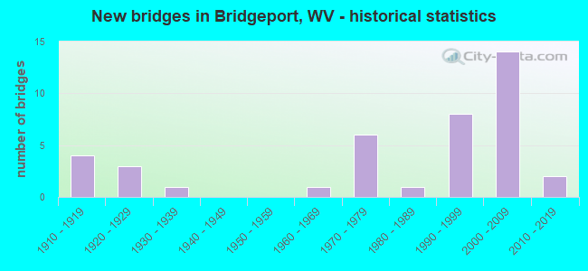
- New bridges - historical statistics
- 41910-1919
- 31920-1929
- 11930-1939
- 11960-1969
- 61970-1979
- 11980-1989
- 81990-1999
- 142000-2009
- 22010-2019


- Bridge Condition - Deck
- 5.6%Very good
- 66.7%Good
- 11.1%Satisfactory
- 11.1%Poor
- 5.6%Serious

- Bridge Condition - Superstructure
- 16.7%Very good
- 43.3%Good
- 6.7%Satisfactory
- 16.7%Fair
- 13.3%Poor
- 3.3%Serious

- Bridge Condition - Substructure
- 11.5%Very good
- 73.1%Good
- 11.5%Fair
- 3.8%Poor

- Bridge Condition - Channel
- 8.0%Excellent
- 20.0%Very good
- 56.0%Good
- 4.0%Satisfactory
- 4.0%Fair
- 8.0%Poor
Find on map >> Show street view
Structure Number: 17A131, Location: 0.12 MI SOUTH CO RT 23/9 (Lat: 39.225111, Lng: -80.247700), Route carried "on" structure: County highway 2303, Year Built: 1991, Status: Open, Structure Length: 1.75m (5.74ft), Average Daily Traffic: 50 (year 2016), Average Future Daily Traffic: 70 (year 2036), Design Load: HS 25 or greater, Features Intersected: BRUSHY FORK, Facility Carried by Structure: HARRISON CR 23/3
Minimum Vertical Clearance: 30+ m (98+ ft), Kilometerpoint: 3.766, Lanes on structure: 1, Owner: State Highway Agency, Approaching Roadway Width: 3.7m (12.1ft), Material/Design: Prestressed concrete, Design/Construction: Box Beam or Girders - Multiple, Number Of Spans In Main Unit: 1, Length of Maximum Span: 17.1m (56.1ft), Curb-To-Curb Width: 4.6m (15.1ft), Out-to-Out Width: 4.6m (15.1ft)
Condition: Superstructure: Good, Substructure: Very good, Channel: Good, Operating Rating: 88.9 metric tons, Method Used To Determine Operating Rating: Load Factor (LF), Inventory Rating: 65.3 metric tons, Method Used To Determine Inventory Rating: Load Factor (LF), Structural Evaluation: Better than present minimum criteria, Deck Geometry: Better than present minimum criteria, Waterway Adequacy: Better than present minimum criteria, Approach Roadway Alignment: Equal to present minimum criteria, Designated Inspection Frequency: Every 48 months, Inspection Date: June 2018, Deck Structure Type: Other, Wearing Surface/Protective System: Deck Protection: Epoxy Coated Reinforcing
Find on map >> Show street view
Structure Number: 17A133, Location: 0.07 MI SOUTH CO RT 23/9 (Lat: 39.217139, Lng: -80.224769), Route carried "on" structure: County highway 2307, Year Built: 1991, Status: Open, Structure Length: 1.69m (5.54ft), Average Daily Traffic: 10 (year 2016), Average Future Daily Traffic: 13 (year 2036), Design Load: HS 25 or greater, Features Intersected: BRUSHY FORK, Facility Carried by Structure: HARRISON CR 23/7
Minimum Vertical Clearance: 30+ m (98+ ft), Kilometerpoint: 0.113, Lanes on structure: 1, Owner: State Highway Agency, Approaching Roadway Width: 4.3m (14.1ft), Skew: 2 degrees, Material/Design: Prestressed concrete, Design/Construction: Box Beam or Girders - Multiple, Number Of Spans In Main Unit: 1, Length of Maximum Span: 16.5m (54.1ft), Curb-To-Curb Width: 4.5m (14.8ft), Out-to-Out Width: 4.6m (15.1ft)
Condition: Deck: Good, Superstructure: Good, Substructure: Very good, Channel: Good, Operating Rating: 88.9 metric tons, Method Used To Determine Operating Rating: Load Factor (LF), Inventory Rating: 67.1 metric tons, Method Used To Determine Inventory Rating: Load Factor (LF), Structural Evaluation: Better than present minimum criteria, Deck Geometry: Equal to present minimum criteria, Waterway Adequacy: Better than present minimum criteria, Approach Roadway Alignment: Equal to present minimum criteria, Designated Inspection Frequency: Every 48 months, Inspection Date: June 2018, Deck Structure Type: Other, Wearing Surface/Protective System: Deck Protection: Epoxy Coated Reinforcing
Find on map >> Show street view
Structure Number: 17A139, Location: 0.07 MI NORTH US RT 50 (Lat: 39.284231, Lng: -80.256150), Route carried "on" structure: County highway 2400, Year Built: 1964, Status: Open, Structure Length: 2.14m (7.02ft), Average Daily Traffic: 7,200 (year 2018), Truck Traffic: 7%, Average Future Daily Traffic: 9,425 (year 2038), Design Load: HS 20, Features Intersected: SIMPSON CREEK, Facility Carried by Structure: HARRISON CO RT 24
Minimum Vertical Clearance: 30+ m (98+ ft), Kilometerpoint: 0.113, Lanes on structure: 2, Owner: State Highway Agency, Approaching Roadway Width: 6.1m (20.0ft), Material/Design: Concrete, Design/Construction: Channel Beam, Number Of Spans In Main Unit: 2, Length of Maximum Span: 9.3m (30.5ft), Curb or Sidewalk Widths: Left: 0.0m, Right: 1.1m (3.6ft), Curb-To-Curb Width: 6.9m (22.6ft), Out-to-Out Width: 8.3m (27.2ft)
Condition: Deck: Poor, Superstructure: Poor, Substructure: Poor, Channel: Fair, Operating Rating: 45.4 metric tons, Method Used To Determine Operating Rating: Field evaluation and documented engineering judgment, Inventory Rating: 20.9 metric tons, Method Used To Determine Inventory Rating: Field evaluation and documented engineering judgment, Structural Evaluation: Meets minimum limits, Deck Geometry: High priority of replacement, Waterway Adequacy: Equal to present minimum criteria, Approach Roadway Alignment: Equal to present desirable criteria, Length Of Structure Improvement: 2.90m (9.51ft), Designated Inspection Frequency: Every 24 months, Other Special Inspection Frequency: Every 12 months, Inspection Date: November 2020, Other Special Inspection Date: November 2021, Bridge Improvement Cost: $371,000, Roadway Improvement Cost: $302,000, Total Project Cost: $804,000 ( Estimate for 2020), Deck Structure Type: Concrete Cast-file-Place, Wearing Surface/Protective System: Wearing Surface: Bituminous
Find on map >> Show street view
Structure Number: 17A145, Location: 0.01 MI SOUTH CO RT 24 (Lat: 39.308919, Lng: -80.278481), Route carried "on" structure: County highway 2434, Year Built: 1978, Status: Posted for load, Structure Length: 2.31m (7.58ft), Average Daily Traffic: 4,000 (year 2020), Truck Traffic: 7%, Average Future Daily Traffic: 6,525 (year 2040), Design Load: HS 20, Features Intersected: SIMPSON CREEK, Facility Carried by Structure: HARRISON CO 24/34
Minimum Vertical Clearance: 30+ m (98+ ft), Kilometerpoint: 0.016, Lanes on structure: 2, Owner: State Highway Agency, Approaching Roadway Width: 7.3m (24.0ft), Material/Design: Prestressed concrete, Design/Construction: Box Beam or Girders - Multiple, Number Of Spans In Main Unit: 1, Length of Maximum Span: 21.9m (71.9ft), Curb-To-Curb Width: 6.9m (22.6ft), Out-to-Out Width: 7.5m (24.6ft)
Condition: Deck: Serious, Superstructure: Serious, Substructure: Fair, Channel: Good, Operating Rating: 32.7 metric tons, Method Used To Determine Operating Rating: Field evaluation and documented engineering judgment, Inventory Rating: 12.7 metric tons, Method Used To Determine Inventory Rating: Field evaluation and documented engineering judgment, Structural Evaluation: High priority of corrective action, Deck Geometry: High priority of replacement, Waterway Adequacy: Better than present minimum criteria, Approach Roadway Alignment: Meets minimum limits, Length Of Structure Improvement: 2.32m (7.61ft), Designated Inspection Frequency: Every 24 months, Other Special Inspection Frequency: Every 12 months, Inspection Date: March 2020, Other Special Inspection Date: March 2021, Bridge Improvement Cost: $374,000, Roadway Improvement Cost: $116,000, Total Project Cost: $584,000 ( Estimate for 2020), Deck Structure Type: Other, Wearing Surface/Protective System: Wearing Surface: Bituminous, Deck Protection: Epoxy Coated Reinforcing
Find on map >> Show street view
Structure Number: 17A21, Location: 0.14 MI WEST WV RT 58 (Lat: 39.281811, Lng: -80.257831), Route carried "on" structure: US 5000, Year Built: 1918, Status: Posted for load, Structure Length: 0.82m (2.69ft), Average Daily Traffic: 15,600 (year 2019), Truck Traffic: 10%, Average Future Daily Traffic: 19,340 (year 2041), Features Intersected: DAVISSON RUN, Facility Carried by Structure: US ROUTE 50
Minimum Vertical Clearance: 30+ m (98+ ft), Kilometerpoint: 31.559, Lanes on structure: 3, Owner: State Highway Agency, Approaching Roadway Width: 10.7m (35.1ft), Skew: 1 degrees, Material/Design: Concrete, Design/Construction: Arch - Deck, Number Of Spans In Main Unit: 1, Length of Maximum Span: 8.2m (26.9ft), Curb or Sidewalk Widths: Left: 1.1m (3.6ft), Right: 0.0m, Curb-To-Curb Width: 11.4m (37.4ft), Out-to-Out Width: 12.8m (42.0ft)
Condition: Superstructure: Poor, Substructure: Good, Channel: Good, Operating Rating: 26.3 metric tons, Method Used To Determine Operating Rating: Field evaluation and documented engineering judgment, Inventory Rating: 11.8 metric tons, Method Used To Determine Inventory Rating: Field evaluation and documented engineering judgment, Structural Evaluation: High priority of replacement, Deck Geometry: High priority of replacement, Waterway Adequacy: Equal to present desirable criteria, Approach Roadway Alignment: Equal to present desirable criteria, Bridge Posting: Required (Relationship of Operating Rating to Maximum Legal Load: 0.1 - 9.9% below), Length Of Structure Improvement: 1.37m (4.49ft), Designated Inspection Frequency: Every 24 months, Inspection Date: January 2022, Bridge Improvement Cost: $271,000, Roadway Improvement Cost: $224,000, Total Project Cost: $611,000 ( Estimate for 2022)
Find on map >> Show street view
Structure Number: 17A228, Location: 0.03 MI WEST CO RT 26 (Lat: 39.276031, Lng: -80.255011), Route carried "on" structure: State highway 5800, Year Built: 1918, Status: Posted for load, Structure Length: 0.87m (2.85ft), Average Daily Traffic: 5,300 (year 2018), Truck Traffic: 4%, Average Future Daily Traffic: 6,950 (year 2038), Features Intersected: DAVISSON RUN, Facility Carried by Structure: WV ROUTE 58
Minimum Vertical Clearance: 30+ m (98+ ft), Kilometerpoint: 8.900, Lanes on structure: 2, Owner: State Highway Agency, Approaching Roadway Width: 7.9m (25.9ft), Material/Design: Concrete, Design/Construction: Arch - Deck, Number Of Spans In Main Unit: 1, Length of Maximum Span: 8.7m (28.5ft), Curb-To-Curb Width: 8.7m (28.5ft), Out-to-Out Width: 9.2m (30.2ft)
Condition: Superstructure: Poor, Substructure: Good, Channel: Satisfactory, Operating Rating: 42.6 metric tons, Method Used To Determine Operating Rating: Field evaluation and documented engineering judgment, Inventory Rating: 20.0 metric tons, Method Used To Determine Inventory Rating: Field evaluation and documented engineering judgment, Structural Evaluation: Meets minimum limits, Deck Geometry: High priority of replacement, Waterway Adequacy: Equal to present desirable criteria, Approach Roadway Alignment: Meets minimum limits, Bridge Posting: Required (Relationship of Operating Rating to Maximum Legal Load: 0.1 - 9.9% below), Length Of Structure Improvement: 1.59m (5.22ft), Designated Inspection Frequency: Every 24 months, Inspection Date: May 2020, Bridge Improvement Cost: $232,000, Roadway Improvement Cost: $174,000, Total Project Cost: $511,000 ( Estimate for 2020)
Find on map >> Show street view
Structure Number: 17A231, Location: 0.19 MI SOUTH CO RT 73/8 (Lat: 39.338011, Lng: -80.222681), Route carried "on" structure: State highway 13100, Year Built: 1972, Status: Open, Structure Length: 10.75m (35.27ft), Average Daily Traffic: 4,900 (year 2019), Truck Traffic: 6%, Average Future Daily Traffic: 9,360 (year 2041), Design Load: HS 20, Features Intersected: Interstate 79, Facility Carried by Structure: WV ROUTE 131
Minimum Vertical Clearance: 30+ m (98+ ft), Kilometerpoint: 6.421, Lanes on structure: 3, Lanes under structure: 4, Owner: State Highway Agency, Approaching Roadway Width: 12.8m (42.0ft), Skew: 3 degrees, Material/Design: Steel continuous, Design/Construction: Stringer/Multi-beam, Number Of Spans In Main Unit: 2, Number Of Approach Spans: 2, Length of Maximum Span: 33.2m (108.9ft), Curb-To-Curb Width: 17.1m (56.1ft), Out-to-Out Width: 17.8m (58.4ft)
Condition: Deck: Good, Superstructure: Good, Substructure: Good, Operating Rating: 42.6 metric tons, Method Used To Determine Operating Rating: Load and Resistance Factor (LRFR), Inventory Rating: 32.7 metric tons, Method Used To Determine Inventory Rating: Load and Resistance Factor (LRFR), Structural Evaluation: Better than present minimum criteria, Deck Geometry: Superior to present desirable criteria, Underclear: Equal to present desirable criteria, Approach Roadway Alignment: Better than present minimum criteria, Designated Inspection Frequency: Every 24 months, Inspection Date: April 2021, Deck Structure Type: Concrete Cast-file-Place
Find on map >> Show street view
Structure Number: 17A232, Location: 0.05 MI NORTH CO RT 73/2 (Lat: 39.354239, Lng: -80.217369), Route carried "on" structure: County highway 7373, Year Built: 1972, Status: Open, Structure Length: 9.89m (32.45ft), Average Daily Traffic: 3,200 (year 2018), Truck Traffic: 7%, Average Future Daily Traffic: 4,200 (year 2038), Design Load: HS 20, Features Intersected: I-79, Facility Carried by Structure: HARRISON CR 73/73
Minimum Vertical Clearance: 30+ m (98+ ft), Kilometerpoint: 1.497, Lanes on structure: 2, Lanes under structure: 4, Owner: State Highway Agency, Approaching Roadway Width: 10.4m (34.1ft), Skew: 2 degrees, Material/Design: Steel continuous, Design/Construction: Stringer/Multi-beam, Number Of Spans In Main Unit: 2, Number Of Approach Spans: 2, Length of Maximum Span: 30.5m (100.1ft), Curb-To-Curb Width: 9.9m (32.5ft), Out-to-Out Width: 11.2m (36.7ft)
Condition: Deck: Good, Superstructure: Good, Substructure: Good, Operating Rating: 65.3 metric tons, Method Used To Determine Operating Rating: Load Factor (LF), Inventory Rating: 39.0 metric tons, Method Used To Determine Inventory Rating: Load Factor (LF), Structural Evaluation: Better than present minimum criteria, Deck Geometry: Meets minimum limits, Underclear: Better than present minimum criteria, Approach Roadway Alignment: Equal to present minimum criteria, Designated Inspection Frequency: Every 24 months, Inspection Date: October 2020, Deck Structure Type: Concrete Cast-file-Place, Wearing Surface/Protective System: Wearing Surface: Latex Concrete
Find on map >> Show street view
Structure Number: 17A236, Location: 0.17 MI WEST CO RT 77/2 (Lat: 39.282439, Lng: -80.226431), Route carried "on" structure: State highway 7600, Year Built: 1923, Status: Open, Structure Length: 1.07m (3.51ft), Average Daily Traffic: 5,700 (year 2019), Truck Traffic: 6%, Average Future Daily Traffic: 10,890 (year 2041), Features Intersected: PEDDLER RUN, Facility Carried by Structure: WV ROUTE 76
Minimum Vertical Clearance: 30+ m (98+ ft), Kilometerpoint: 0.692, Lanes on structure: 2, Owner: State Highway Agency, Approaching Roadway Width: 9.1m (29.9ft), Material/Design: Concrete, Design/Construction: Arch - Deck, Number Of Spans In Main Unit: 1, Length of Maximum Span: 10.7m (35.1ft), Curb-To-Curb Width: 8.9m (29.2ft), Out-to-Out Width: 9.2m (30.2ft)
Condition: Superstructure: Fair, Substructure: Good, Channel: Good, Operating Rating: 63.5 metric tons, Method Used To Determine Operating Rating: Field evaluation and documented engineering judgment, Inventory Rating: 29.0 metric tons, Method Used To Determine Inventory Rating: Field evaluation and documented engineering judgment, Structural Evaluation: Somewhat better than minimum adequacy, Deck Geometry: High priority of replacement, Waterway Adequacy: Equal to present minimum criteria, Approach Roadway Alignment: Equal to present desirable criteria, Length Of Structure Improvement: 1.80m (5.91ft), Designated Inspection Frequency: Every 24 months, Inspection Date: October 2021, Bridge Improvement Cost: $264,000, Roadway Improvement Cost: $202,000, Total Project Cost: $544,000 ( Estimate for 2022)
Find on map >> Show street view
Structure Number: 17A245, Location: 0.27 MI EAST WV RT 58 (Lat: 39.285131, Lng: -80.251981), Route carried "on" structure: US 5000, Year Built: 1985, Status: Open, Structure Length: 2.71m (8.89ft), Average Daily Traffic: 15,300 (year 2019), Truck Traffic: 7%, Average Future Daily Traffic: 20,050 (year 2039), Design Load: HS 20, Features Intersected: SIMPSON CREEK, Facility Carried by Structure: US ROUTE 50
Minimum Vertical Clearance: 30+ m (98+ ft), Kilometerpoint: 32.219, Lanes on structure: 2, Owner: State Highway Agency, Approaching Roadway Width: 9.8m (32.2ft), Material/Design: Steel, Design/Construction: Stringer/Multi-beam, Number Of Spans In Main Unit: 1, Length of Maximum Span: 25.9m (85.0ft), Curb or Sidewalk Widths: Left: 1.5m (4.9ft), Right: 1.5m (4.9ft), Curb-To-Curb Width: 9.8m (32.2ft), Out-to-Out Width: 13.4m (44.0ft)
Condition: Deck: Good, Superstructure: Good, Substructure: Good, Channel: Good, Operating Rating: 88.9 metric tons, Method Used To Determine Operating Rating: Load Factor (LF), Inventory Rating: 54.4 metric tons, Method Used To Determine Inventory Rating: Load Factor (LF), Structural Evaluation: Better than present minimum criteria, Deck Geometry: Meets minimum limits, Waterway Adequacy: Equal to present minimum criteria, Approach Roadway Alignment: Better than present minimum criteria, Designated Inspection Frequency: Every 24 months, Inspection Date: Febuary 2021, Deck Structure Type: Concrete Cast-file-Place, Wearing Surface/Protective System: Deck Protection: Epoxy Coated Reinforcing
Find on map >> Show street view
Structure Number: 17A277, Location: 0.07 MI SOUTH CO RT 17 (Lat: 39.265919, Lng: -80.211750), Route carried "on" structure: County highway 7704, Year Built: 1920, Status: Open, Structure Length: 0.64m (2.10ft), Average Daily Traffic: 50 (year 2019), Average Future Daily Traffic: 70 (year 2041), Features Intersected: BEARDS RUN, Facility Carried by Structure: HARRISON CR 77/4
Minimum Vertical Clearance: 30+ m (98+ ft), Kilometerpoint: 4.522, Lanes on structure: 1, Owner: State Highway Agency, Approaching Roadway Width: 4.6m (15.1ft), Material/Design: Concrete, Design/Construction: Arch - Deck, Number Of Spans In Main Unit: 1, Length of Maximum Span: 6.4m (21.0ft), Curb-To-Curb Width: 4.8m (15.7ft), Out-to-Out Width: 5.5m (18.0ft)
Condition: Superstructure: Fair, Substructure: Good, Channel: Poor, Operating Rating: 47.2 metric tons, Method Used To Determine Operating Rating: Field evaluation and documented engineering judgment, Inventory Rating: 21.8 metric tons, Method Used To Determine Inventory Rating: Field evaluation and documented engineering judgment, Structural Evaluation: Somewhat better than minimum adequacy, Deck Geometry: Equal to present desirable criteria, Waterway Adequacy: Somewhat better than minimum adequacy, Approach Roadway Alignment: Equal to present desirable criteria, Length Of Structure Improvement: 1.28m (4.20ft), Designated Inspection Frequency: Every 24 months, Inspection Date: July 2021, Bridge Improvement Cost: $237,000, Roadway Improvement Cost: $125,000, Total Project Cost: $420,000 ( Estimate for 2021)
Find on map >> Show street view
Structure Number: 17A284, Location: 0.86 MI NORTH CO RT 24 (Lat: 39.310989, Lng: -80.261139), Route carried "on" structure: Interstate 7900, Year Built: 1973, Status: Open, Structure Length: 0.61m (2.00ft), Average Daily Traffic: 23,650 (year 2018), Truck Traffic: 20%, Average Future Daily Traffic: 34,300 (year 2038), Features Intersected: BARNETT RUN, Facility Carried by Structure: I-79 SB & ON RAMP
Minimum Vertical Clearance: 30+ m (98+ ft), Kilometerpoint: 196.662, Lanes on structure: 4, Base Highway Network: Yes, Owner: State Highway Agency, Approaching Roadway Width: 19.2m (63.0ft), Skew: 5 degrees, Material/Design: Concrete, Design/Construction: Culvert, Number Of Spans In Main Unit: 1, Length of Maximum Span: 6.1m (20.0ft)
Condition: Channel: Good, Culverts: Satisfactory, Operating Rating: 71.7 metric tons, Method Used To Determine Operating Rating: Field evaluation and documented engineering judgment, Inventory Rating: 32.7 metric tons, Method Used To Determine Inventory Rating: Field evaluation and documented engineering judgment, Structural Evaluation: Equal to present minimum criteria, Waterway Adequacy: Equal to present desirable criteria, Approach Roadway Alignment: Better than present minimum criteria, Designated Inspection Frequency: Every 24 months, Inspection Date: Febuary 2020
Find on map >> Show street view
Structure Number: 17A291, Location: 0.76 MI SOUTH Co Rt 707 (Lat: 39.327519, Lng: -80.235450), Route carried "on" structure: State highway 27900, Year Built: 1995, Status: Open, Structure Length: 12.16m (39.90ft), Average Daily Traffic: 13,700 (year 2018), Truck Traffic: 4%, Average Future Daily Traffic: 17,950 (year 2038), Design Load: HS 25 or greater, Features Intersected: INTERSTATE 79, Facility Carried by Structure: WV RT 279
Minimum Vertical Clearance: 30+ m (98+ ft), Kilometerpoint: 4.490, Lanes on structure: 4, Lanes under structure: 4, Owner: State Highway Agency, Approaching Roadway Width: 25.9m (85.0ft), Skew: 24 degrees, Material/Design: Prestressed concrete continuous, Design/Construction: Stringer/Multi-beam, Number Of Spans In Main Unit: 2, Number Of Approach Spans: 2, Length of Maximum Span: 41.1m (134.8ft), Curb-To-Curb Width: 22.6m (74.1ft), Out-to-Out Width: 23.6m (77.4ft)
Condition: Deck: Good, Superstructure: Fair, Substructure: Good, Operating Rating: 61.7 metric tons, Method Used To Determine Operating Rating: Load Factor (LF), Inventory Rating: 37.2 metric tons, Method Used To Determine Inventory Rating: Load Factor (LF), Structural Evaluation: Somewhat better than minimum adequacy, Deck Geometry: Superior to present desirable criteria, Underclear: Better than present minimum criteria, Approach Roadway Alignment: Superior to present desirable criteria, Designated Inspection Frequency: Every 24 months, Inspection Date: July 2020, Deck Structure Type: Concrete Cast-file-Place, Wearing Surface/Protective System: Deck Protection: Epoxy Coated Reinforcing
Find on map >> Show street view
Structure Number: 17A302, Location: 0.43 MI SOUTH CO RT 73/1 (Lat: 39.363519, Lng: -80.208581), Route carried "on" structure: County highway 7373, Year Built: 1998, Status: Open, Structure Length: 1.40m (4.59ft), Average Daily Traffic: 3,400 (year 2016), Truck Traffic: 7%, Average Future Daily Traffic: 4,450 (year 2036), Design Load: HS 25 or greater, Features Intersected: THOMAS FORK, Facility Carried by Structure: HARR CO RT 73/73
Minimum Vertical Clearance: 30+ m (98+ ft), Kilometerpoint: 2.913, Lanes on structure: 2, Owner: State Highway Agency, Approaching Roadway Width: 7.0m (23.0ft), Skew: 2 degrees, Material/Design: Prestressed concrete, Design/Construction: Box Beam or Girders - Multiple, Number Of Spans In Main Unit: 1, Length of Maximum Span: 12.5m (41.0ft), Curb-To-Curb Width: 8.9m (29.2ft), Out-to-Out Width: 9.4m (30.8ft)
Condition: Deck: Good, Superstructure: Very good, Substructure: Good, Channel: Good, Operating Rating: 72.6 metric tons, Method Used To Determine Operating Rating: Load Factor (LF), Inventory Rating: 43.5 metric tons, Method Used To Determine Inventory Rating: Load Factor (LF), Structural Evaluation: Better than present minimum criteria, Deck Geometry: Meets minimum limits, Waterway Adequacy: Superior to present desirable criteria, Approach Roadway Alignment: Equal to present desirable criteria, Designated Inspection Frequency: Every 48 months, Inspection Date: May 2018, Deck Structure Type: Concrete Cast-file-Place, Wearing Surface/Protective System: Deck Protection: Epoxy Coated Reinforcing
Find on map >> Show street view
Structure Number: 17A314, Location: 1.07 mi N. Harr Co 50/14 (Lat: 39.313419, Lng: -80.222789), Route carried "on" structure: State highway 27900, Year Built: 2001, Status: Open, Structure Length: 3.81m (12.50ft), Average Daily Traffic: 10,100 (year 2019), Truck Traffic: 6%, Average Future Daily Traffic: 19,300 (year 2041), Design Load: HL 93, Features Intersected: WV 131 & Ann Run, Facility Carried by Structure: WV ROUTE 279
Minimum Vertical Clearance: 30+ m (98+ ft), Kilometerpoint: 2.591, Lanes on structure: 4, Lanes under structure: 2, Owner: State Highway Agency, Approaching Roadway Width: 21.0m (68.9ft), Skew: 20 degrees, Material/Design: Prestressed concrete, Design/Construction: Stringer/Multi-beam, Number Of Spans In Main Unit: 1, Length of Maximum Span: 37.2m (122.0ft), Curb-To-Curb Width: 25.0m (82.0ft), Out-to-Out Width: 25.8m (84.6ft)
Condition: Deck: Good, Superstructure: Very good, Substructure: Good, Channel: Excellent, Operating Rating: 75.3 metric tons, Method Used To Determine Operating Rating: Load and Resistance Factor (LRFR), Inventory Rating: 47.2 metric tons, Method Used To Determine Inventory Rating: Load and Resistance Factor (LRFR), Structural Evaluation: Better than present minimum criteria, Deck Geometry: Superior to present desirable criteria, Underclear: Equal to present minimum criteria, Waterway Adequacy: Superior to present desirable criteria, Approach Roadway Alignment: Better than present minimum criteria, Designated Inspection Frequency: Every 24 months, Inspection Date: April 2021, Deck Structure Type: Concrete Cast-file-Place, Wearing Surface/Protective System: Wearing Surface: Integral Concrete, Deck Protection: Epoxy Coated Reinforcing
Find on map >> Show street view
Structure Number: 17A316, Location: 2.06 MI NORTH US RT 50 (Lat: 39.306969, Lng: -80.274681), Route carried "on" structure: Interstate 7900, Year Built: 2002, Status: Open, Structure Length: 6.69m (21.95ft), Average Daily Traffic: 28,700 (year 2019), Truck Traffic: 13%, Average Future Daily Traffic: 36,700 (year 2041), Design Load: HL 93, Features Intersected: Har Co 24, Facility Carried by Structure: INTERSTATE 79 NB
Minimum Vertical Clearance: 30+ m (98+ ft), Kilometerpoint: 195.246, Lanes on structure: 3, Lanes under structure: 4, Base Highway Network: Yes, Owner: State Highway Agency, Approaching Roadway Width: 17.7m (58.1ft), Skew: 2 degrees, Material/Design: Steel continuous, Design/Construction: Stringer/Multi-beam, Number Of Spans In Main Unit: 1, Number Of Approach Spans: 2, Length of Maximum Span: 25.0m (82.0ft), Curb-To-Curb Width: 17.7m (58.1ft), Out-to-Out Width: 18.4m (60.4ft)
Condition: Deck: Satisfactory, Superstructure: Good, Substructure: Good, Operating Rating: 25.4 metric tons, Method Used To Determine Operating Rating: Load and Resistance Factor (LRFR), Inventory Rating: 20.0 metric tons, Method Used To Determine Inventory Rating: Load and Resistance Factor (LRFR), Structural Evaluation: Somewhat better than minimum adequacy, Deck Geometry: Better than present minimum criteria, Underclear: Meets minimum limits, Approach Roadway Alignment: Superior to present desirable criteria, Designated Inspection Frequency: Every 24 months, Inspection Date: January 2021, Deck Structure Type: Concrete Cast-file-Place, Wearing Surface/Protective System: Deck Protection: Epoxy Coated Reinforcing
Find on map >> Show street view
Structure Number: 17A317, Location: 2.06 MI NORTH US RT 50 (Lat: 39.306739, Lng: -80.274550), Route carried "on" structure: Interstate 7900, Year Built: 2002, Status: Open, Structure Length: 6.69m (21.95ft), Average Daily Traffic: 28,700 (year 2019), Truck Traffic: 13%, Average Future Daily Traffic: 36,700 (year 2041), Design Load: HL 93, Features Intersected: Har Co 24, Facility Carried by Structure: INTERSTATE 79 SB
Minimum Vertical Clearance: 30+ m (98+ ft), Kilometerpoint: 195.246, Lanes on structure: 3, Lanes under structure: 4, Base Highway Network: Yes, Owner: State Highway Agency, Approaching Roadway Width: 17.7m (58.1ft), Skew: 2 degrees, Material/Design: Steel continuous, Design/Construction: Stringer/Multi-beam, Number Of Spans In Main Unit: 1, Number Of Approach Spans: 2, Length of Maximum Span: 25.0m (82.0ft), Curb-To-Curb Width: 17.7m (58.1ft), Out-to-Out Width: 18.4m (60.4ft)
Condition: Deck: Satisfactory, Superstructure: Good, Substructure: Good, Operating Rating: 25.4 metric tons, Method Used To Determine Operating Rating: Load and Resistance Factor (LRFR), Inventory Rating: 19.0 metric tons, Method Used To Determine Inventory Rating: Load and Resistance Factor (LRFR), Structural Evaluation: Meets minimum limits, Deck Geometry: Better than present minimum criteria, Underclear: Meets minimum limits, Approach Roadway Alignment: Superior to present desirable criteria, Designated Inspection Frequency: Every 24 months, Inspection Date: January 2021, Deck Structure Type: Concrete Cast-file-Place, Wearing Surface/Protective System: Deck Protection: Epoxy Coated Reinforcing
Find on map >> Show street view
Structure Number: 17A319, Location: 0.65 MI SOUTH HRR CO 24 (Lat: 39.298300, Lng: -80.279000), Route carried "on" structure: Interstate 7900, Year Built: 2004, Status: Open, Structure Length: 7.03m (23.06ft), Average Daily Traffic: 57,700 (year 2019), Truck Traffic: 13%, Average Future Daily Traffic: 73,850 (year 2041), Design Load: HL 93, Features Intersected: Simpson Creek/private dr, Facility Carried by Structure: INTERSTATE 79
Minimum Vertical Clearance: 30+ m (98+ ft), Kilometerpoint: 194.200, Lanes on structure: 4, Lanes under structure: 1, Base Highway Network: Yes, Owner: State Highway Agency, Approaching Roadway Width: 40.8m (133.9ft), Skew: 33 degrees, Material/Design: Steel continuous, Design/Construction: Stringer/Multi-beam, Number Of Spans In Main Unit: 1, Number Of Approach Spans: 2, Length of Maximum Span: 26.5m (86.9ft), Curb-To-Curb Width: 40.8m (133.9ft), Out-to-Out Width: 42.2m (138.5ft)
Condition: Deck: Good, Superstructure: Good, Substructure: Good, Channel: Very good, Operating Rating: 68.0 metric tons, Method Used To Determine Operating Rating: Load and Resistance Factor (LRFR), Inventory Rating: 48.1 metric tons, Method Used To Determine Inventory Rating: Load and Resistance Factor (LRFR), Structural Evaluation: Better than present minimum criteria, Deck Geometry: Superior to present desirable criteria, Underclear: High priority of corrective action, Waterway Adequacy: Superior to present desirable criteria, Approach Roadway Alignment: Equal to present desirable criteria, Designated Inspection Frequency: Every 24 months, Inspection Date: November 2021, Deck Structure Type: Concrete Cast-file-Place, Wearing Surface/Protective System: Deck Protection: Epoxy Coated Reinforcing
Find on map >> Show street view
Structure Number: 17A321, Location: 0.01 MI WEST OF CO RT 24 (Lat: 39.314489, Lng: -80.283581), Route carried "on" structure: County highway 2401, Year Built: 2003, Status: Open, Structure Length: 4.35m (14.27ft), Average Daily Traffic: 500 (year 2020), Truck Traffic: 7%, Average Future Daily Traffic: 650 (year 2040), Design Load: HL 93, Features Intersected: SIMPSON CREEK, Facility Carried by Structure: HARR. CO RT 24/1
Minimum Vertical Clearance: 30+ m (98+ ft), Kilometerpoint: 9.318, Lanes on structure: 2, Owner: State Highway Agency, Approaching Roadway Width: 7.3m (24.0ft), Material/Design: Prestressed concrete, Design/Construction: Stringer/Multi-beam, Number Of Spans In Main Unit: 1, Length of Maximum Span: 42.4m (139.1ft), Curb-To-Curb Width: 8.5m (27.9ft), Out-to-Out Width: 9.3m (30.5ft)
Condition: Deck: Good, Superstructure: Very good, Substructure: Good, Channel: Very good, Operating Rating: 69.8 metric tons, Method Used To Determine Operating Rating: Load and Resistance Factor (LRFR), Inventory Rating: 53.5 metric tons, Method Used To Determine Inventory Rating: Load and Resistance Factor (LRFR), Structural Evaluation: Better than present minimum criteria, Deck Geometry: Somewhat better than minimum adequacy, Waterway Adequacy: Superior to present desirable criteria, Approach Roadway Alignment: Equal to present minimum criteria, Designated Inspection Frequency: Every 24 months, Inspection Date: May 2020, Deck Structure Type: Concrete Cast-file-Place, Wearing Surface/Protective System: Deck Protection: Epoxy Coated Reinforcing
Find on map >> Show street view
Structure Number: 17A322, Location: 0.09 MI NORTH CO RT 50/16 (Lat: 39.288831, Lng: -80.277719), Route carried "on" structure: County highway 5076, Year Built: 2004, Status: Open, Structure Length: 14.10m (46.26ft), Average Daily Traffic: 8,100 (year 2019), Truck Traffic: 7%, Average Future Daily Traffic: 10,600 (year 2039), Design Load: Greater than HL93, Features Intersected: CSX RR, Har. Co. 50/25, Facility Carried by Structure: HAR CO RT 50/76
Minimum Vertical Clearance: 30+ m (98+ ft), Kilometerpoint: 0.789, Lanes on structure: 2, Lanes under structure: 2, Owner: State Highway Agency, Approaching Roadway Width: 12.2m (40.0ft), Material/Design: Prestressed concrete continuous, Design/Construction: Stringer/Multi-beam, Number Of Spans In Main Unit: 1, Number Of Approach Spans: 3, Length of Maximum Span: 43.6m (143.0ft), Curb-To-Curb Width: 12.2m (40.0ft), Out-to-Out Width: 13.0m (42.7ft)
Condition: Deck: Good, Superstructure: Good, Substructure: Good, Operating Rating: 56.2 metric tons, Method Used To Determine Operating Rating: Load and Resistance Factor (LRFR), Inventory Rating: 43.5 metric tons, Method Used To Determine Inventory Rating: Load and Resistance Factor (LRFR), Structural Evaluation: Better than present minimum criteria, Deck Geometry: Somewhat better than minimum adequacy, Underclear: Equal to present minimum criteria, Approach Roadway Alignment: Equal to present desirable criteria, Designated Inspection Frequency: Every 24 months, Inspection Date: Febuary 2021, Deck Structure Type: Concrete Cast-file-Place, Wearing Surface/Protective System: Wearing Surface: Monolithic Concrete, Deck Protection: Epoxy Coated Reinforcing
Find on map >> Show street view
Structure Number: 17A323, Location: 0.20 MI SOUTH HRR CO 24 (Lat: 39.297361, Lng: -80.277600), Route carried "on" structure: County highway 5076, Year Built: 2000, Status: Open, Structure Length: 3.00m (9.84ft), Average Daily Traffic: 8,100 (year 2019), Truck Traffic: 8%, Average Future Daily Traffic: 11,100 (year 2041), Design Load: HS 25 or greater, Features Intersected: SIMPSON CREEK, Facility Carried by Structure: HAR CO RT 50/76
Minimum Vertical Clearance: 30+ m (98+ ft), Kilometerpoint: 1.835, Lanes on structure: 2, Owner: State Highway Agency, Approaching Roadway Width: 9.4m (30.8ft), Skew: 1 degrees, Material/Design: Prestressed concrete, Design/Construction: Stringer/Multi-beam, Number Of Spans In Main Unit: 1, Length of Maximum Span: 28.9m (94.8ft), Curb or Sidewalk Widths: Left: 0.0m, Right: 1.5m (4.9ft), Curb-To-Curb Width: 12.0m (39.4ft), Out-to-Out Width: 14.3m (46.9ft)
Condition: Deck: Good, Superstructure: Very good, Substructure: Good, Channel: Very good, Operating Rating: 88.9 metric tons, Method Used To Determine Operating Rating: Load Factor (LF), Inventory Rating: 77.1 metric tons, Method Used To Determine Inventory Rating: Load Factor (LF), Structural Evaluation: Better than present minimum criteria, Deck Geometry: Somewhat better than minimum adequacy, Waterway Adequacy: Equal to present desirable criteria, Approach Roadway Alignment: Equal to present minimum criteria, Designated Inspection Frequency: Every 48 months, Inspection Date: November 2021, Deck Structure Type: Concrete Cast-file-Place, Wearing Surface/Protective System: Deck Protection: Epoxy Coated Reinforcing
Find on map >> Show street view
Structure Number: 17A352, Location: 0.02 N Har. Co. 77/3 (Lat: 39.269089, Lng: -80.213519), Route carried "on" structure: County highway 17, Year Built: 2014, Status: Open, Structure Length: 1.58m (5.18ft), Average Daily Traffic: 1,000 (year 2019), Truck Traffic: 8%, Average Future Daily Traffic: 1,370 (year 2041), Design Load: HL 93, Features Intersected: Simpson Creek
Minimum Vertical Clearance: 30+ m (98+ ft), Kilometerpoint: 1.996, Lanes on structure: 2, Owner: State Highway Agency, Approaching Roadway Width: 6.1m (20.0ft), Material/Design: Prestressed concrete, Design/Construction: Box Beam or Girders - Multiple, Number Of Spans In Main Unit: 1, Length of Maximum Span: 14.6m (47.9ft), Curb-To-Curb Width: 8.3m (27.2ft), Out-to-Out Width: 8.3m (27.2ft)
Condition: Deck: Very good, Superstructure: Very good, Substructure: Very good, Channel: Very good, Operating Rating: 49.9 metric tons, Method Used To Determine Operating Rating: Load and Resistance Factor (LRFR), Inventory Rating: 39.9 metric tons, Method Used To Determine Inventory Rating: Load and Resistance Factor (LRFR), Structural Evaluation: Equal to present desirable criteria, Deck Geometry: Somewhat better than minimum adequacy, Waterway Adequacy: Equal to present desirable criteria, Approach Roadway Alignment: Better than present minimum criteria, Designated Inspection Frequency: Every 48 months, Inspection Date: March 2021, Deck Structure Type: Other, Wearing Surface/Protective System: Wearing Surface: Bituminous
Find on map >> Show street view
Structure Number: 17A9, Location: 0.02 MI NORTH US RT 50 (Lat: 39.288261, Lng: -80.247850), Route carried "on" structure: City street N0195, Year Built: 1930, Status: Posted for load, Structure Length: 0.85m (2.79ft), Average Daily Traffic: 1,000 (year 2019), Truck Traffic: 7%, Average Future Daily Traffic: 1,370 (year 2041), Features Intersected: ANN RUN, Facility Carried by Structure: CENTER STREET
Minimum Vertical Clearance: 30+ m (98+ ft), Kilometerpoint: 0.016, Lanes on structure: 2, Owner: City or Municipal Highway Agency, Approaching Roadway Width: 5.8m (19.0ft), Material/Design: Concrete, Design/Construction: Tee Beam, Number Of Spans In Main Unit: 1, Length of Maximum Span: 7.5m (24.6ft), Curb or Sidewalk Widths: Left: 1.4m (4.6ft), Right: 0.0m, Curb-To-Curb Width: 5.7m (18.7ft), Out-to-Out Width: 7.5m (24.6ft)
Condition: Deck: Poor, Superstructure: Poor, Substructure: Fair, Channel: Good, Operating Rating: 31.7 metric tons, Method Used To Determine Operating Rating: Field evaluation and documented engineering judgment, Inventory Rating: 14.5 metric tons, Method Used To Determine Inventory Rating: Field evaluation and documented engineering judgment, Structural Evaluation: Meets minimum limits, Deck Geometry: High priority of replacement, Waterway Adequacy: Equal to present desirable criteria, Approach Roadway Alignment: Equal to present desirable criteria, Bridge Posting: Required (Relationship of Operating Rating to Maximum Legal Load: 20.0 - 29.9% below), Length Of Structure Improvement: 1.46m (4.79ft), Designated Inspection Frequency: Every 24 months, Inspection Date: May 2021, Bridge Improvement Cost: $201,000, Roadway Improvement Cost: $156,000, Total Project Cost: $438,000 ( Estimate for 2021), Deck Structure Type: Concrete Cast-file-Place, Wearing Surface/Protective System: Wearing Surface: Bituminous
Find on map >> Show street view
Structure Number: 17A901, Location: 0.01 MI EAST OF PENN AVE (Lat: 39.288419, Lng: -80.247419), Route carried "on" structure: City street N0195, Year Built: 1924, Status: Posted for load, Structure Length: 0.93m (3.05ft), Average Daily Traffic: 750 (year 2019), Truck Traffic: 7%, Average Future Daily Traffic: 1,030 (year 2041), Design Load: H 15, Features Intersected: ANN RUN, Facility Carried by Structure: Lawman Avenue
Minimum Vertical Clearance: 30+ m (98+ ft), Kilometerpoint: 0.032, Lanes on structure: 2, Owner: City or Municipal Highway Agency, Approaching Roadway Width: 5.5m (18.0ft), Material/Design: Concrete, Design/Construction: Arch - Deck, Number Of Spans In Main Unit: 1, Length of Maximum Span: 9.3m (30.5ft), Curb or Sidewalk Widths: Left: 0.9m (3.0ft), Right: 0.0m, Curb-To-Curb Width: 5.1m (16.7ft), Out-to-Out Width: 5.7m (18.7ft)
Condition: Superstructure: Good, Channel: Good, Operating Rating: 47.2 metric tons, Method Used To Determine Operating Rating: Field evaluation and documented engineering judgment, Inventory Rating: 21.8 metric tons, Method Used To Determine Inventory Rating: Field evaluation and documented engineering judgment, Structural Evaluation: Somewhat better than minimum adequacy, Deck Geometry: High priority of replacement, Waterway Adequacy: Equal to present minimum criteria, Approach Roadway Alignment: Meets minimum limits, Length Of Structure Improvement: 1.52m (4.99ft), Designated Inspection Frequency: Every 24 months, Inspection Date: September 2021, Bridge Improvement Cost: $187,000, Roadway Improvement Cost: $148,000, Total Project Cost: $402,000 ( Estimate for 2021)
Find on map >> Show street view
Structure Number: 17A919, Location: 0.18 MI WEST HARR CO 24 (Lat: 39.289439, Lng: -80.265661), Route carried "on" structure: City street N0195, Year Built: 1995, Status: Open, Structure Length: 2.28m (7.48ft), Average Daily Traffic: 1,000 (year 2020), Truck Traffic: 6%, Average Future Daily Traffic: 1,625 (year 2040), Design Load: HS 20, Features Intersected: SIMPSON CREEK, Facility Carried by Structure: ACCESS ROAD
Minimum Vertical Clearance: 30+ m (98+ ft), Kilometerpoint: 0.080, Lanes on structure: 1, Owner: City or Municipal Highway Agency, Approaching Roadway Width: 4.3m (14.1ft), Material/Design: Prestressed concrete, Design/Construction: Box Beam or Girders - Multiple, Number Of Spans In Main Unit: 1, Length of Maximum Span: 21.3m (69.9ft), Curb or Sidewalk Widths: Left: 0.0m, Right: 1.0m (3.3ft), Curb-To-Curb Width: 4.3m (14.1ft), Out-to-Out Width: 5.6m (18.4ft)
Condition: Superstructure: Good, Substructure: Good, Channel: Good, Operating Rating: 88.9 metric tons, Method Used To Determine Operating Rating: Load Factor (LF), Inventory Rating: 62.6 metric tons, Method Used To Determine Inventory Rating: Load Factor (LF), Structural Evaluation: Better than present minimum criteria, Deck Geometry: High priority of replacement, Waterway Adequacy: Equal to present minimum criteria, Approach Roadway Alignment: Equal to present desirable criteria, Designated Inspection Frequency: Every 24 months, Inspection Date: May 2020, Deck Structure Type: Other, Wearing Surface/Protective System: Wearing Surface: Bituminous, Deck Protection: Epoxy Coated Reinforcing
Find on map >> Show street view
Structure Number: 17A924, Location: PHILADELPHIA AVE BRDGPORT (Lat: 39.286911, Lng: -80.248539), Route carried "on" structure: City street N0195, Year Built: 2010, Status: Open, Structure Length: 0.98m (3.22ft), Average Daily Traffic: 2,000 (year 2019), Truck Traffic: 8%, Average Future Daily Traffic: 2,740 (year 2041), Design Load: HL 93, Features Intersected: ANN RUN, Facility Carried by Structure: PHILADELPHIA AVE
Minimum Vertical Clearance: 30+ m (98+ ft), Kilometerpoint: 0.097, Lanes on structure: 2, Owner: City or Municipal Highway Agency, Approaching Roadway Width: 5.8m (19.0ft), Material/Design: Concrete, Design/Construction: Arch - Deck, Number Of Spans In Main Unit: 1, Length of Maximum Span: 9.8m (32.2ft), Curb or Sidewalk Widths: Left: 1.7m (5.6ft), Right: 0.0m, Curb-To-Curb Width: 7.3m (24.0ft), Out-to-Out Width: 9.6m (31.5ft)
Condition: Superstructure: Good, Channel: Good, Operating Rating: 88.9 metric tons, Method Used To Determine Operating Rating: Field evaluation and documented engineering judgment, Inventory Rating: 40.8 metric tons, Method Used To Determine Inventory Rating: Field evaluation and documented engineering judgment, Structural Evaluation: Better than present minimum criteria, Deck Geometry: Meets minimum limits, Waterway Adequacy: Equal to present desirable criteria, Approach Roadway Alignment: Equal to present minimum criteria, Designated Inspection Frequency: Every 24 months, Inspection Date: May 2021
Find on map >> Show street view
Structure Number: 17A925, Location: 0.03 miles N of WV 131 (Lat: 39.297311, Lng: -80.240719), Route carried "on" structure: City street N0195, Year Built: 2008, Status: Open, Structure Length: 2.01m (6.59ft), Average Daily Traffic: 25 (year 2019), Average Future Daily Traffic: 40 (year 2041), Design Load: HS 25 or greater, Features Intersected: Ann Run, Facility Carried by Structure: City Street
Minimum Vertical Clearance: 30+ m (98+ ft), Kilometerpoint: 0.113, Lanes on structure: 2, Owner: City or Municipal Highway Agency, Approaching Roadway Width: 11.6m (38.1ft), Material/Design: Concrete, Design/Construction: Arch - Deck, Number Of Spans In Main Unit: 1, Length of Maximum Span: 18.3m (60.0ft), Curb or Sidewalk Widths: Left: 1.6m (5.2ft), Right: 2.4m (7.9ft), Curb-To-Curb Width: 11.9m (39.0ft), Out-to-Out Width: 17.9m (58.7ft)
Condition: Superstructure: Satisfactory, Channel: Very good, Operating Rating: 88.9 metric tons, Method Used To Determine Operating Rating: Field evaluation and documented engineering judgment, Inventory Rating: 40.8 metric tons, Method Used To Determine Inventory Rating: Field evaluation and documented engineering judgment, Structural Evaluation: Equal to present minimum criteria, Deck Geometry: Superior to present desirable criteria, Waterway Adequacy: Equal to present desirable criteria, Approach Roadway Alignment: Better than present minimum criteria, Designated Inspection Frequency: Every 24 months, Inspection Date: July 2021
Find on map >> Show street view
Structure Number: 46A002, Location: 0.02 MI EAST CO RT 1 (Lat: 39.365489, Lng: -80.198811), Route carried "on" structure: County highway 102, Year Built: 1911, Status: Open, Structure Length: 0.81m (2.66ft), Average Daily Traffic: 50 (year 2019), Average Future Daily Traffic: 69 (year 2041), Features Intersected: CORBIN BRANCH, Facility Carried by Structure: TAYLOR CO RT 1/2
Minimum Vertical Clearance: 30+ m (98+ ft), Kilometerpoint: 0.032, Lanes on structure: 1, Owner: State Highway Agency, Approaching Roadway Width: 4.3m (14.1ft), Material/Design: Concrete, Design/Construction: Arch - Deck, Number Of Spans In Main Unit: 1, Length of Maximum Span: 8.1m (26.6ft), Curb-To-Curb Width: 4.4m (14.4ft), Out-to-Out Width: 4.8m (15.7ft)
Condition: Superstructure: Fair, Channel: Good, Operating Rating: 47.2 metric tons, Method Used To Determine Operating Rating: Field evaluation and documented engineering judgment, Inventory Rating: 21.8 metric tons, Method Used To Determine Inventory Rating: Field evaluation and documented engineering judgment, Structural Evaluation: Somewhat better than minimum adequacy, Deck Geometry: Equal to present minimum criteria, Waterway Adequacy: Meets minimum limits, Approach Roadway Alignment: High priority of corrective action, Length Of Structure Improvement: 1.49m (4.89ft), Designated Inspection Frequency: Every 24 months, Inspection Date: April 2021, Bridge Improvement Cost: $174,000, Roadway Improvement Cost: $138,000, Total Project Cost: $392,000 ( Estimate for 2021)
Find on map >> Show street view
Structure Number: 46A003, Location: 0.14 MI EAST CO RT 1 (Lat: 39.353100, Lng: -80.196300), Route carried "on" structure: County highway 104, Year Built: 1911, Status: Open, Structure Length: 0.70m (2.30ft), Average Daily Traffic: 100 (year 2019), Average Future Daily Traffic: 180 (year 2041), Features Intersected: CORBIN BRANCH, Facility Carried by Structure: TAYLOR CO RT 1/4
Minimum Vertical Clearance: 30+ m (98+ ft), Kilometerpoint: 0.225, Lanes on structure: 1, Owner: State Highway Agency, Approaching Roadway Width: 4.9m (16.1ft), Material/Design: Concrete, Design/Construction: Arch - Deck, Number Of Spans In Main Unit: 1, Length of Maximum Span: 7.0m (23.0ft), Curb-To-Curb Width: 4.3m (14.1ft), Out-to-Out Width: 4.8m (15.7ft)
Condition: Superstructure: Fair, Substructure: Fair, Channel: Poor, Operating Rating: 47.2 metric tons, Method Used To Determine Operating Rating: Field evaluation and documented engineering judgment, Inventory Rating: 21.8 metric tons, Method Used To Determine Inventory Rating: Field evaluation and documented engineering judgment, Structural Evaluation: Somewhat better than minimum adequacy, Deck Geometry: Equal to present minimum criteria, Waterway Adequacy: Somewhat better than minimum adequacy, Approach Roadway Alignment: Better than present minimum criteria, Length Of Structure Improvement: 1.28m (4.20ft), Designated Inspection Frequency: Every 24 months, Inspection Date: October 2021, Bridge Improvement Cost: $244,000, Roadway Improvement Cost: $128,000, Total Project Cost: $468,000 ( Estimate for 2022)
Find on map >> Show street view
Structure Number: 46A023, Location: 0.47 MI WEST OF WV RT 76 (Lat: 39.272311, Lng: -80.192181), Route carried "on" structure: County highway 1317, Year Built: 1996, Status: Open, Structure Length: 2.26m (7.41ft), Average Daily Traffic: 50 (year 2018), Average Future Daily Traffic: 60 (year 2038), Design Load: HS 25 or greater, Features Intersected: SIMPSON CREEK, Facility Carried by Structure: COUNTY ROUTE 13/17
Minimum Vertical Clearance: 30+ m (98+ ft), Kilometerpoint: 0.756, Lanes on structure: 2, Owner: State Highway Agency, Approaching Roadway Width: 4.9m (16.1ft), Skew: 2 degrees, Material/Design: Prestressed concrete, Design/Construction: Box Beam or Girders - Multiple, Number Of Spans In Main Unit: 1, Length of Maximum Span: 21.3m (69.9ft), Curb-To-Curb Width: 6.3m (20.7ft), Out-to-Out Width: 6.5m (21.3ft)
Condition: Deck: Good, Superstructure: Good, Substructure: Good, Channel: Good, Operating Rating: 88.9 metric tons, Method Used To Determine Operating Rating: Load Factor (LF), Inventory Rating: 68.0 metric tons, Method Used To Determine Inventory Rating: Load Factor (LF), Structural Evaluation: Better than present minimum criteria, Deck Geometry: Somewhat better than minimum adequacy, Waterway Adequacy: Equal to present desirable criteria, Approach Roadway Alignment: Somewhat better than minimum adequacy, Designated Inspection Frequency: Every 48 months, Inspection Date: April 2020, Deck Structure Type: Other, Wearing Surface/Protective System: Deck Protection: Epoxy Coated Reinforcing
Find on map >> Show street view
Structure Number: 46A075, Location: 0.01 MI EAST TAY CO RT 3 (Lat: 39.322519, Lng: -80.156969), Route carried "on" structure: County highway 800, Year Built: 1994, Status: Open, Structure Length: 1.20m (3.94ft), Average Daily Traffic: 1,100 (year 2018), Truck Traffic: 6%, Average Future Daily Traffic: 1,300 (year 2038), Design Load: HS 25 or greater, Features Intersected: HUSTEAD FORK, Facility Carried by Structure: TAYLOR CO RT 8
Minimum Vertical Clearance: 30+ m (98+ ft), Kilometerpoint: 2.865, Lanes on structure: 2, Owner: State Highway Agency, Approaching Roadway Width: 6.1m (20.0ft), Skew: 2 degrees, Material/Design: Prestressed concrete, Design/Construction: Box Beam or Girders - Multiple, Number Of Spans In Main Unit: 1, Length of Maximum Span: 11.6m (38.1ft), Curb-To-Curb Width: 6.3m (20.7ft), Out-to-Out Width: 6.5m (21.3ft)
Condition: Superstructure: Satisfactory, Substructure: Good, Channel: Excellent, Operating Rating: 88.9 metric tons, Method Used To Determine Operating Rating: Load Factor (LF), Inventory Rating: 64.4 metric tons, Method Used To Determine Inventory Rating: Load Factor (LF), Structural Evaluation: Equal to present minimum criteria, Deck Geometry: High priority of replacement, Waterway Adequacy: Equal to present desirable criteria, Approach Roadway Alignment: Better than present minimum criteria, Designated Inspection Frequency: Every 24 months, Inspection Date: August 2020, Deck Structure Type: Other, Wearing Surface/Protective System: Deck Protection: Epoxy Coated Reinforcing
Find on map >> Show street view
Structure Number: 17A231, Location: 0.19 MI SOUTH CO RT 73/8 (Lat: 39.338011, Lng: -80.222681), Route carried "under" structure: Interstate 7900, Year Built: 1972, Structure Length: 0. m, Average Daily Traffic: 48,225 (year 0017), Truck Traffic: 20%, Features Intersected: Interstate 79, Facility Carried by Structure: WV ROUTE 131
Minimum Vertical Clearance: 6.15m (20.18ft), Kilometerpoint: 201.168, Lanes on structure: 3, Lanes under structure: 4, Length of Maximum Span: 33.2m (108.9ft)
Find on map >> Show street view
Structure Number: 17A232, Location: 0.05 MI NORTH CO RT 73/2 (Lat: 39.354239, Lng: -80.217369), Route carried "under" structure: Interstate 7900, Year Built: 1972, Structure Length: 0. m, Average Daily Traffic: 36,200 (year 0018), Truck Traffic: 20%, Features Intersected: I-79, Facility Carried by Structure: HARRISON CR 73/73
Minimum Vertical Clearance: 5.66m (18.57ft), Kilometerpoint: 203.067, Lanes on structure: 2, Lanes under structure: 4, Length of Maximum Span: 30.5m (100.1ft)
Find on map >> Show street view
Structure Number: 17A291, Location: 0.76 MI SOUTH Co Rt 707 (Lat: 39.327519, Lng: -80.235450), Route carried "under" structure: Interstate 7900, Year Built: 1995, Structure Length: 0. m, Average Daily Traffic: 47,200 (year 0018), Truck Traffic: 20%, Features Intersected: INTERSTATE 79, Facility Carried by Structure: WV RT 279
Minimum Vertical Clearance: 6.58m (21.59ft), Kilometerpoint: 199.559, Lanes on structure: 4, Lanes under structure: 4, Length of Maximum Span: 41.1m (134.8ft)
Find on map >> Show street view
Structure Number: 17A314, Location: 1.07 mi N. Harr Co 50/14 (Lat: 39.313419, Lng: -80.222789), Route carried "under" structure: State highway 13100, Year Built: 2001, Structure Length: 0. m, Average Daily Traffic: 4,800 (year 0015), Truck Traffic: 4%, Features Intersected: WV 131 & Ann Run, Facility Carried by Structure: WV ROUTE 279
Minimum Vertical Clearance: 5.33m (17.49ft), Kilometerpoint: 3.380, Lanes on structure: 4, Lanes under structure: 2, Length of Maximum Span: 37.2m (122.0ft)
Find on map >> Show street view
Structure Number: 17A316, Location: 2.06 MI NORTH US RT 50 (Lat: 39.306969, Lng: -80.274681), Route carried "under" structure: County highway 2400, Year Built: 2002, Structure Length: 0. m, Average Daily Traffic: 16,500 (year 0018), Truck Traffic: 7%, Features Intersected: Har Co 24, Facility Carried by Structure: INTERSTATE 79 NB
Minimum Vertical Clearance: 5.23m (17.16ft), Kilometerpoint: 3.927, Lanes on structure: 3, Lanes under structure: 4, Length of Maximum Span: 25.0m (82.0ft)
Find on map >> Show street view
Structure Number: 17A317, Location: 2.06 MI NORTH US RT 50 (Lat: 39.306739, Lng: -80.274550), Route carried "under" structure: County highway 2400, Year Built: 2002, Structure Length: 0. m, Average Daily Traffic: 16,500 (year 0018), Truck Traffic: 7%, Features Intersected: Har Co 24, Facility Carried by Structure: INTERSTATE 79 SB
Minimum Vertical Clearance: 5.74m (18.83ft), Kilometerpoint: 3.927, Lanes on structure: 3, Lanes under structure: 4, Length of Maximum Span: 25.0m (82.0ft)
Find on map >> Show street view
Structure Number: 17A319, Location: 0.65 MI SOUTH HRR CO 24 (Lat: 39.288481, Lng: -80.280100), Route carried "under" structure: Other road , Year Built: 2004, Structure Length: 0. m, Average Daily Traffic: 20 (year 0019), Features Intersected: Simpson Creek/private dr, Facility Carried by Structure: INTERSTATE 79
Minimum Vertical Clearance: 4.50m (14.76ft), Kilometerpoint: 0.000, Lanes on structure: 4, Lanes under structure: 1, Length of Maximum Span: 26.5m (86.9ft)
Find on map >> Show street view
Structure Number: 17A319, Location: 0.65 MI SOUTH HRR CO 24 (Lat: 39.288811, Lng: -80.280181), Route carried "under" structure: Other road , Year Built: 2004, Structure Length: 0. m, Average Daily Traffic: 10 (year 0019), Features Intersected: Simpson Creek/private dr, Facility Carried by Structure: INTERSTATE 79
Minimum Vertical Clearance: 6.48m (21.26ft), Kilometerpoint: 0.000, Lanes on structure: 4, Lanes under structure: 1, Length of Maximum Span: 26.5m (86.9ft)
Find on map >> Show street view
Structure Number: 17A322, Location: 0.09 MI NORTH CO RT 50/16 (Lat: 39.288831, Lng: -80.277719), Route carried "under" structure: County highway 5025, Year Built: 2004, Structure Length: 0. m, Average Daily Traffic: 10 (year 0019), Features Intersected: CSX RR, Har. Co. 50/25, Facility Carried by Structure: HAR CO RT 50/76
Minimum Vertical Clearance: 13.89m (45.57ft), Kilometerpoint: 0.113, Lanes on structure: 2, Lanes under structure: 2, Length of Maximum Span: 43.6m (143.0ft)