Bridge Statistics for Brewton, Alabama (AL)
Condition, Traffic, Stress, Structural Evaluation, Project Costs
- National Bridge Inventory (NBI) Statistics
- 20Number of bridges
- 400ft / 122mTotal length
- $41,796,000Total costs
- 82,577Total average daily traffic
- 4,179Total average daily truck traffic
- National Bridge Inventory (NBI) Registered Bridges for Brewton
- No street view available for this location
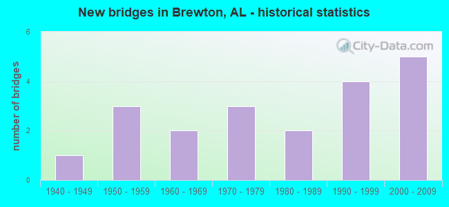
- New bridges - historical statistics
- 11940-1949
- 31950-1959
- 21960-1969
- 31970-1979
- 21980-1989
- 41990-1999
- 52000-2009


- Bridge Condition - Deck
- 50.0%Good
- 20.0%Satisfactory
- 30.0%Fair

- Bridge Condition - Superstructure
- 20.0%Very good
- 30.0%Good
- 40.0%Satisfactory
- 10.0%Fair

- Bridge Condition - Substructure
- 20.0%Very good
- 50.0%Good
- 20.0%Satisfactory
- 10.0%Fair

- Bridge Condition - Channel
- 15.8%Very good
- 21.1%Good
- 42.1%Satisfactory
- 21.1%Fair

- Bridge Condition - Culverts
- 33.3%Good
- 33.3%Satisfactory
- 22.2%Fair
- 11.1%Poor
Find on map >> Show street view
Structure Number: 2835, Location: 1.9 MI S CO RD 55 (Lat: 31.033522, Lng: -87.049694), Route carried "on" structure: State highway 41, Year Built: 1945, Status: Open, Structure Length: 0.67m (2.20ft), Average Daily Traffic: 2,960 (year 2019), Truck Traffic: 6%, Average Future Daily Traffic: 4,440 (year 2039), Design Load: H 15, Features Intersected: COBB BRANCH
Minimum Vertical Clearance: 30+ m (98+ ft), Kilometerpoint: 4.128, Lanes on structure: 2, Owner: State Highway Agency, Approaching Roadway Width: 8.7m (28.5ft), Material/Design: Concrete, Design/Construction: Culvert, Number Of Spans In Main Unit: 2, Length of Maximum Span: 3.0m (9.8ft)
Condition: Channel: Satisfactory, Culverts: Good, Operating Rating: 78.9 metric tons, Method Used To Determine Operating Rating: Load Factor (LF), Inventory Rating: 47.4 metric tons, Method Used To Determine Inventory Rating: Load Factor (LF), Structural Evaluation: Better than present minimum criteria, Waterway Adequacy: Better than present minimum criteria, Approach Roadway Alignment: Equal to present desirable criteria, Length Of Structure Improvement: 1.30m (4.27ft), Designated Inspection Frequency: Every 24 months, Inspection Date: March 2021, Bridge Improvement Cost: $278,000, Roadway Improvement Cost: $28,000, Total Project Cost: $306,000 ( Estimate for 2022)
Find on map >> Show street view
Structure Number: 4541, Location: 1.5 MI N CO RD 18 (Lat: 31.088306, Lng: -87.096444), Route carried "on" structure: US 31, Year Built: 1953, Year Reconstructed: 1967, Status: Open, Structure Length: 0.94m (3.08ft), Average Daily Traffic: 10,649 (year 2019), Truck Traffic: 7%, Average Future Daily Traffic: 15,974 (year 2039), Design Load: H 15, Features Intersected: MAYS BRANCH
Minimum Vertical Clearance: 30+ m (98+ ft), Kilometerpoint: 108.652, Lanes on structure: 4, Owner: State Highway Agency, Approaching Roadway Width: 17.0m (55.8ft), Skew: 10 degrees, Material/Design: Concrete, Design/Construction: Culvert, Number Of Spans In Main Unit: 3, Length of Maximum Span: 3.0m (9.8ft)
Condition: Channel: Fair, Culverts: Poor, Operating Rating: 88.9 metric tons, Method Used To Determine Operating Rating: Load Factor (LF), Inventory Rating: 88.9 metric tons, Method Used To Determine Inventory Rating: Load Factor (LF), Structural Evaluation: Meets minimum limits, Waterway Adequacy: Somewhat better than minimum adequacy, Approach Roadway Alignment: Equal to present desirable criteria, Length Of Structure Improvement: 1.62m (5.31ft), Designated Inspection Frequency: Every 24 months, Other Special Inspection Frequency: Every 12 months, Inspection Date: Febuary 2021, Other Special Inspection Date: Febuary 2022, Bridge Improvement Cost: $1,327,000, Roadway Improvement Cost: $133,000, Total Project Cost: $1,460,000 ( Estimate for 2022)
Find on map >> Show street view
Structure Number: 4542, Location: 0.3 MI S SR 41 (Lat: 31.100936, Lng: -87.076711), Route carried "on" structure: US 31, Year Built: 1953, Status: Open, Structure Length: 16.49m (54.10ft), Average Daily Traffic: 8,186 (year 2019), Truck Traffic: 2%, Average Future Daily Traffic: 12,279 (year 2039), Design Load: HS 20, Features Intersected: BURNT CORN CREEK
Minimum Vertical Clearance: 30+ m (98+ ft), Kilometerpoint: 111.005, Lanes on structure: 2, Owner: State Highway Agency, Approaching Roadway Width: 8.4m (27.6ft), Material/Design: Steel continuous, Design/Construction: Stringer/Multi-beam, Number Of Spans In Main Unit: 3, Number Of Approach Spans: 10, Length of Maximum Span: 24.4m (80.1ft), Curb or Sidewalk Widths: Left: 1.2m (3.9ft), Right: 1.2m (3.9ft), Curb-To-Curb Width: 8.4m (27.6ft), Out-to-Out Width: 11.6m (38.1ft)
Condition: Deck: Fair, Superstructure: Satisfactory, Substructure: Satisfactory, Channel: Satisfactory, Operating Rating: 47.3 metric tons, Method Used To Determine Operating Rating: Load Factor (LF), Inventory Rating: 28.4 metric tons, Method Used To Determine Inventory Rating: Load Factor (LF), Structural Evaluation: Equal to present minimum criteria, Deck Geometry: High priority of corrective action, Waterway Adequacy: Somewhat better than minimum adequacy, Approach Roadway Alignment: Better than present minimum criteria, Length Of Structure Improvement: 17.23m (56.53ft), Designated Inspection Frequency: Every 24 months, Inspection Date: March 2021, Bridge Improvement Cost: $4,489,000, Roadway Improvement Cost: $449,000, Total Project Cost: $4,938,000 ( Estimate for 2022), Deck Structure Type: Concrete Cast-file-Place
Find on map >> Show street view
Structure Number: 508, Location: 0.3 MI N CO RD 18 (Lat: 31.080058, Lng: -87.114242), Route carried "on" structure: US 31, Year Built: 1955, Year Reconstructed: 1967, Status: Open, Structure Length: 1.22m (4.00ft), Average Daily Traffic: 10,649 (year 2019), Truck Traffic: 7%, Average Future Daily Traffic: 15,974 (year 2039), Design Load: HS 20, Features Intersected: FRANKLIN MILL CREEK
Minimum Vertical Clearance: 30+ m (98+ ft), Kilometerpoint: 106.719, Lanes on structure: 4, Owner: State Highway Agency, Approaching Roadway Width: 17.1m (56.1ft), Skew: 11 degrees, Material/Design: Concrete, Design/Construction: Culvert, Number Of Spans In Main Unit: 3, Length of Maximum Span: 3.7m (12.1ft)
Condition: Channel: Fair, Culverts: Fair, Operating Rating: 88.9 metric tons, Method Used To Determine Operating Rating: Load Factor (LF), Inventory Rating: 59.9 metric tons, Method Used To Determine Inventory Rating: Load Factor (LF), Structural Evaluation: Somewhat better than minimum adequacy, Waterway Adequacy: Somewhat better than minimum adequacy, Approach Roadway Alignment: Equal to present desirable criteria, Length Of Structure Improvement: 1.89m (6.20ft), Designated Inspection Frequency: Every 24 months, Inspection Date: March 2021, Bridge Improvement Cost: $1,399,000, Roadway Improvement Cost: $140,000, Total Project Cost: $1,539,000 ( Estimate for 2022)
Find on map >> Show street view
Structure Number: 9756, Location: 1.5MI E N.BREWTON (Lat: 31.169117, Lng: -87.098175), Route carried "on" structure: ServiceCounty highway 77, Year Built: 1968, Status: Posted for load, Structure Length: 14.75m (48.39ft), Average Daily Traffic: 250 (year 1988), Truck Traffic: 5%, Average Future Daily Traffic: 363 (year 2034), Design Load: H 15, Features Intersected: BURNT CORN CREEK, Facility Carried by Structure: COUNTY HIGHWAY
Minimum Vertical Clearance: 30+ m (98+ ft), Kilometerpoint: 0.010, Lanes on structure: 2, Owner: County Highway Agency, Approaching Roadway Width: 9.1m (29.9ft), Material/Design: Steel, Design/Construction: Stringer/Multi-beam, Number Of Spans In Main Unit: 2, Number Of Approach Spans: 11, Length of Maximum Span: 16.8m (55.1ft), Curb or Sidewalk Widths: Left: 0.2m (0.7ft), Right: 0.2m (0.7ft), Curb-To-Curb Width: 6.7m (22.0ft), Out-to-Out Width: 7.1m (23.3ft)
Condition: Deck: Fair, Superstructure: Satisfactory, Substructure: Fair, Channel: Satisfactory, Operating Rating: 38.5 metric tons, Method Used To Determine Operating Rating: Allowable Stress (AS), Inventory Rating: 23.5 metric tons, Method Used To Determine Inventory Rating: Allowable Stress (AS), Structural Evaluation: Somewhat better than minimum adequacy, Deck Geometry: Meets minimum limits, Waterway Adequacy: Equal to present desirable criteria, Approach Roadway Alignment: Equal to present minimum criteria, Bridge Posting: Required (Relationship of Operating Rating to Maximum Legal Load: 10.0 - 19.9% below), Length Of Structure Improvement: 15.53m (50.95ft), Designated Inspection Frequency: Every 24 months, Other Special Inspection Frequency: Every 12 months, Inspection Date: October 2020, Other Special Inspection Date: October 2021, Bridge Improvement Cost: $2,449,000, Roadway Improvement Cost: $245,000, Total Project Cost: $2,694,000 ( Estimate for 2022), Deck Structure Type: Concrete Cast-file-Place
Find on map >> Show street view
Structure Number: 10072, Location: 1.5MI W N.BREWTON (Lat: 31.163386, Lng: -87.099867), Route carried "on" structure: County highway 77, Year Built: 1969, Status: Open, Structure Length: 0.67m (2.20ft), Average Daily Traffic: 250 (year 1988), Truck Traffic: 5%, Average Future Daily Traffic: 156 (year 2034), Design Load: H 15, Features Intersected: SEVEN MILE CREEK RELIEF, Facility Carried by Structure: COUNTY HIGHWAY
Minimum Vertical Clearance: 30+ m (98+ ft), Kilometerpoint: 0.010, Lanes on structure: 2, Owner: County Highway Agency, Approaching Roadway Width: 9.1m (29.9ft), Material/Design: Concrete, Design/Construction: Culvert, Number Of Spans In Main Unit: 2, Length of Maximum Span: 3.4m (11.2ft), Curb-To-Curb Width: 9.3m (30.5ft), Out-to-Out Width: 9.8m (32.2ft)
Condition: Channel: Satisfactory, Culverts: Satisfactory, Operating Rating: 44.1 metric tons, Method Used To Determine Operating Rating: Load Factor (LF), Inventory Rating: 26.4 metric tons, Method Used To Determine Inventory Rating: Load Factor (LF), Structural Evaluation: Equal to present minimum criteria, Deck Geometry: Equal to present minimum criteria, Waterway Adequacy: Better than present minimum criteria, Approach Roadway Alignment: Better than present minimum criteria, Length Of Structure Improvement: 1.30m (4.27ft), Designated Inspection Frequency: Every 24 months, Inspection Date: October 2020, Bridge Improvement Cost: $240,000, Roadway Improvement Cost: $24,000, Total Project Cost: $264,000 ( Estimate for 2022), Wearing Surface/Protective System: Wearing Surface: Bituminous
Find on map >> Show street view
Structure Number: 10384, Location: 0.2 M N OF DOUGLAS LANE (Lat: 31.141006, Lng: -87.062000), Route carried "on" structure: City street , Year Built: 1970, Status: Open, Structure Length: 0.64m (2.10ft), Average Daily Traffic: 36 (year 2019), Average Future Daily Traffic: 216 (year 2039), Features Intersected: KING'S BRANCH, Facility Carried by Structure: SOWELL ROAD
Minimum Vertical Clearance: 7.56m (24.80ft), Kilometerpoint: 0.249, Lanes on structure: 2, Owner: City or Municipal Highway Agency, Approaching Roadway Width: 8.5m (27.9ft), Material/Design: Concrete, Design/Construction: Culvert, Number Of Spans In Main Unit: 2, Length of Maximum Span: 3.0m (9.8ft)
Condition: Channel: Good, Culverts: Satisfactory, Operating Rating: 39.9 metric tons, Method Used To Determine Operating Rating: Load Factor (LF), Inventory Rating: 23.9 metric tons, Method Used To Determine Inventory Rating: Load Factor (LF), Structural Evaluation: Equal to present minimum criteria, Waterway Adequacy: Better than present minimum criteria, Approach Roadway Alignment: Better than present minimum criteria, Length Of Structure Improvement: 1.26m (4.13ft), Designated Inspection Frequency: Every 24 months, Inspection Date: October 2021, Bridge Improvement Cost: $197,000, Roadway Improvement Cost: $20,000, Total Project Cost: $217,000 ( Estimate for 2022), Wearing Surface/Protective System: Wearing Surface: Bituminous
Find on map >> Show street view
Structure Number: 1039, Location: 1.5MI W N.BREWTON (Lat: 31.162317, Lng: -87.099039), Route carried "on" structure: County highway 77, Year Built: 1970, Status: Open, Structure Length: 0.79m (2.59ft), Average Daily Traffic: 250 (year 1988), Truck Traffic: 5%, Average Future Daily Traffic: 390 (year 2034), Design Load: H 15, Features Intersected: SEVEN MILE CREEK, Facility Carried by Structure: COUNTY HIGHWAY
Minimum Vertical Clearance: 30+ m (98+ ft), Kilometerpoint: 0.010, Lanes on structure: 2, Owner: County Highway Agency, Approaching Roadway Width: 7.3m (24.0ft), Material/Design: Concrete, Design/Construction: Culvert, Number Of Spans In Main Unit: 2, Length of Maximum Span: 4.0m (13.1ft), Curb-To-Curb Width: 7.3m (24.0ft), Out-to-Out Width: 11.0m (36.1ft)
Condition: Channel: Satisfactory, Culverts: Fair, Operating Rating: 77.2 metric tons, Method Used To Determine Operating Rating: Load Factor (LF), Inventory Rating: 46.3 metric tons, Method Used To Determine Inventory Rating: Load Factor (LF), Structural Evaluation: Somewhat better than minimum adequacy, Deck Geometry: Somewhat better than minimum adequacy, Waterway Adequacy: Better than present minimum criteria, Approach Roadway Alignment: Somewhat better than minimum adequacy, Length Of Structure Improvement: 1.44m (4.72ft), Designated Inspection Frequency: Every 24 months, Inspection Date: October 2020, Bridge Improvement Cost: $300,000, Roadway Improvement Cost: $30,000, Total Project Cost: $330,000 ( Estimate for 2022), Wearing Surface/Protective System: Wearing Surface: Bituminous
Find on map >> Show street view
Structure Number: 11996, Location: 0.3 MI E ST JOSEPH ST (Lat: 31.100806, Lng: -87.068083), Route carried "on" structure: City street , Year Built: 1978, Status: Open, Structure Length: 14.51m (47.60ft), Average Daily Traffic: 1,538 (year 2021), Truck Traffic: 10%, Average Future Daily Traffic: 2,025 (year 2041), Design Load: H 15, Features Intersected: MURDER CREEK, Facility Carried by Structure: LEE STREET
Minimum Vertical Clearance: 30+ m (98+ ft), Kilometerpoint: 0.299, Lanes on structure: 2, Owner: City or Municipal Highway Agency, Approaching Roadway Width: 7.7m (25.3ft), Material/Design: Concrete, Design/Construction: Channel Beam, Number Of Spans In Main Unit: 14, Length of Maximum Span: 10.4m (34.1ft), Curb-To-Curb Width: 8.7m (28.5ft), Out-to-Out Width: 9.6m (31.5ft)
Condition: Deck: Fair, Superstructure: Fair, Substructure: Satisfactory, Channel: Satisfactory, Operating Rating: 39.6 metric tons, Method Used To Determine Operating Rating: Load Factor (LF), Inventory Rating: 23.8 metric tons, Method Used To Determine Inventory Rating: Load Factor (LF), Structural Evaluation: Somewhat better than minimum adequacy, Deck Geometry: Somewhat better than minimum adequacy, Waterway Adequacy: Equal to present minimum criteria, Approach Roadway Alignment: Equal to present minimum criteria, Length Of Structure Improvement: 15.29m (50.16ft), Designated Inspection Frequency: Every 24 months, Underwater Inspection Frequency: Every 24 months, Inspection Date: January 2021, Underwater Inspection Date: January 2021, Bridge Improvement Cost: $3,251,000, Roadway Improvement Cost: $325,000, Total Project Cost: $3,576,000 ( Estimate for 2022), Deck Structure Type: Concrete Precast Panels, Wearing Surface/Protective System: Wearing Surface: Bituminous
Find on map >> Show street view
Structure Number: 13608, Location: 0.4 MI S E US 31 (Lat: 31.100994, Lng: -87.069228), Route carried "on" structure: US 29, Year Built: 1985, Status: Open, Structure Length: 15.09m (49.51ft), Average Daily Traffic: 13,831 (year 2019), Truck Traffic: 5%, Average Future Daily Traffic: 20,747 (year 2039), Design Load: HS 20, Features Intersected: MURDER CREEK
Minimum Vertical Clearance: 30+ m (98+ ft), Kilometerpoint: 0.435, Lanes on structure: 2, Owner: State Highway Agency, Approaching Roadway Width: 20.7m (67.9ft), Material/Design: Steel continuous, Design/Construction: Stringer/Multi-beam, Number Of Spans In Main Unit: 3, Number Of Approach Spans: 9, Length of Maximum Span: 18.3m (60.0ft), Curb or Sidewalk Widths: Left: 1.5m (4.9ft), Right: 1.5m (4.9ft), Curb-To-Curb Width: 15.8m (51.8ft), Out-to-Out Width: 19.5m (64.0ft)
Condition: Deck: Good, Superstructure: Satisfactory, Substructure: Good, Channel: Fair, Operating Rating: 49.4 metric tons, Method Used To Determine Operating Rating: Load Factor (LF), Inventory Rating: 29.6 metric tons, Method Used To Determine Inventory Rating: Load Factor (LF), Structural Evaluation: Equal to present minimum criteria, Deck Geometry: Superior to present desirable criteria, Waterway Adequacy: Meets minimum limits, Approach Roadway Alignment: Better than present minimum criteria, Length Of Structure Improvement: 15.86m (52.03ft), Designated Inspection Frequency: Every 24 months, Underwater Inspection Frequency: Every 24 months, Inspection Date: March 2021, Underwater Inspection Date: January 2022, Bridge Improvement Cost: $6,960,000, Roadway Improvement Cost: $696,000, Total Project Cost: $7,656,000 ( Estimate for 2022), Deck Structure Type: Concrete Cast-file-Place
Find on map >> Show street view
Structure Number: 13912, Location: 1.2 MI N SR 41 (Lat: 31.085628, Lng: -87.048094), Route carried "on" structure: US 29, Year Built: 1986, Status: Open, Structure Length: 1.13m (3.71ft), Average Daily Traffic: 2,362 (year 2020), Truck Traffic: 12%, Average Future Daily Traffic: 3,543 (year 2040), Design Load: HS 20, Features Intersected: MANTEL CREEK
Minimum Vertical Clearance: 30+ m (98+ ft), Kilometerpoint: 3.290, Lanes on structure: 2, Owner: State Highway Agency, Approaching Roadway Width: 7.5m (24.6ft), Skew: 3 degrees, Material/Design: Concrete, Design/Construction: Culvert, Number Of Spans In Main Unit: 3, Length of Maximum Span: 3.0m (9.8ft)
Condition: Channel: Fair, Culverts: Satisfactory, Operating Rating: 56.0 metric tons, Method Used To Determine Operating Rating: Load Factor (LF), Inventory Rating: 33.6 metric tons, Method Used To Determine Inventory Rating: Load Factor (LF), Structural Evaluation: Equal to present minimum criteria, Waterway Adequacy: Somewhat better than minimum adequacy, Approach Roadway Alignment: Equal to present minimum criteria, Length Of Structure Improvement: 1.80m (5.91ft), Designated Inspection Frequency: Every 24 months, Inspection Date: January 2022, Bridge Improvement Cost: $541,000, Roadway Improvement Cost: $54,000, Total Project Cost: $595,000 ( Estimate for 2022)
Find on map >> Show street view
Structure Number: 15889, Location: 2 MI N US 31 (Lat: 31.129147, Lng: -87.087258), Route carried "on" structure: State highway 41, Year Built: 1994, Status: Open, Structure Length: 10.39m (34.09ft), Average Daily Traffic: 2,067 (year 2019), Truck Traffic: 9%, Average Future Daily Traffic: 3,101 (year 2039), Design Load: HS 20, Features Intersected: BURNT CORN CREEK
Minimum Vertical Clearance: 30+ m (98+ ft), Kilometerpoint: 16.060, Lanes on structure: 2, Owner: State Highway Agency, Approaching Roadway Width: 13.4m (44.0ft), Material/Design: Prestressed concrete continuous, Design/Construction: Stringer/Multi-beam, Number Of Spans In Main Unit: 3, Number Of Approach Spans: 3, Length of Maximum Span: 24.7m (81.0ft), Curb-To-Curb Width: 13.4m (44.0ft), Out-to-Out Width: 14.3m (46.9ft)
Condition: Deck: Satisfactory, Superstructure: Good, Substructure: Good, Channel: Good, Operating Rating: 36.7 metric tons, Method Used To Determine Operating Rating: Load Factor (LF), Inventory Rating: 22.0 metric tons, Method Used To Determine Inventory Rating: Load Factor (LF), Structural Evaluation: Somewhat better than minimum adequacy, Deck Geometry: Better than present minimum criteria, Waterway Adequacy: Equal to present minimum criteria, Approach Roadway Alignment: Better than present minimum criteria, Length Of Structure Improvement: 11.31m (37.11ft), Designated Inspection Frequency: Every 24 months, Inspection Date: March 2021, Bridge Improvement Cost: $3,567,000, Roadway Improvement Cost: $357,000, Total Project Cost: $3,924,000 ( Estimate for 2022), Deck Structure Type: Concrete Cast-file-Place
Find on map >> Show street view
Structure Number: 1589, Location: 1.9 MI N US 31 (Lat: 31.127714, Lng: -87.085428), Route carried "on" structure: State highway 41, Year Built: 1994, Status: Open, Structure Length: 8.23m (27.00ft), Average Daily Traffic: 2,067 (year 2019), Truck Traffic: 11%, Average Future Daily Traffic: 3,101 (year 2039), Design Load: HS 20, Features Intersected: BURNT CORN RELIEF
Minimum Vertical Clearance: 30+ m (98+ ft), Kilometerpoint: 15.815, Lanes on structure: 2, Owner: State Highway Agency, Approaching Roadway Width: 13.4m (44.0ft), Skew: 3 degrees, Material/Design: Prestressed concrete continuous, Design/Construction: Stringer/Multi-beam, Number Of Spans In Main Unit: 8, Length of Maximum Span: 10.4m (34.1ft), Curb-To-Curb Width: 13.4m (44.0ft), Out-to-Out Width: 14.3m (46.9ft)
Condition: Deck: Satisfactory, Superstructure: Good, Substructure: Good, Channel: Good, Operating Rating: 34.7 metric tons, Method Used To Determine Operating Rating: Load Factor (LF), Inventory Rating: 27.8 metric tons, Method Used To Determine Inventory Rating: Load Factor (LF), Structural Evaluation: Equal to present minimum criteria, Deck Geometry: Better than present minimum criteria, Waterway Adequacy: Equal to present desirable criteria, Approach Roadway Alignment: Equal to present desirable criteria, Length Of Structure Improvement: 9.23m (30.28ft), Designated Inspection Frequency: Every 24 months, Inspection Date: March 2021, Bridge Improvement Cost: $2,911,000, Roadway Improvement Cost: $291,000, Total Project Cost: $3,202,000 ( Estimate for 2022), Deck Structure Type: Concrete Cast-file-Place
Find on map >> Show street view
Structure Number: 16008, Location: 0.3 MI S SR 41 (Lat: 31.100667, Lng: -87.077111), Route carried "on" structure: US 31, Year Built: 1997, Status: Open, Structure Length: 16.49m (54.10ft), Average Daily Traffic: 8,186 (year 2019), Truck Traffic: 2%, Average Future Daily Traffic: 12,279 (year 2039), Design Load: HS 20, Features Intersected: BURNT CORN CREEK
Minimum Vertical Clearance: 30+ m (98+ ft), Kilometerpoint: 111.005, Lanes on structure: 2, Owner: State Highway Agency, Approaching Roadway Width: 12.2m (40.0ft), Skew: 30 degrees, Material/Design: Prestressed concrete, Design/Construction: Stringer/Multi-beam, Number Of Spans In Main Unit: 3, Number Of Approach Spans: 10, Length of Maximum Span: 24.4m (80.1ft), Curb-To-Curb Width: 12.2m (40.0ft), Out-to-Out Width: 13.0m (42.7ft)
Condition: Deck: Good, Superstructure: Satisfactory, Substructure: Good, Channel: Satisfactory, Operating Rating: 54.8 metric tons, Method Used To Determine Operating Rating: Load Factor (LF), Inventory Rating: 32.7 metric tons, Method Used To Determine Inventory Rating: Load Factor (LF), Structural Evaluation: Equal to present minimum criteria, Deck Geometry: Somewhat better than minimum adequacy, Waterway Adequacy: Equal to present desirable criteria, Approach Roadway Alignment: Equal to present desirable criteria, Length Of Structure Improvement: 17.23m (56.53ft), Designated Inspection Frequency: Every 24 months, Inspection Date: March 2021, Bridge Improvement Cost: $4,961,000, Roadway Improvement Cost: $496,000, Total Project Cost: $5,457,000 ( Estimate for 2022), Deck Structure Type: Concrete Cast-file-Place
Find on map >> Show street view
Structure Number: 16723, Location: 500FT N DACUS ST (Lat: 31.126667, Lng: -87.051667), Route carried "on" structure: City street , Year Built: 1998, Status: Open, Structure Length: 1.20m (3.94ft), Average Daily Traffic: 2,325 (year 2019), Truck Traffic: 5%, Average Future Daily Traffic: 4,134 (year 2039), Design Load: HS 20, Features Intersected: KINGS BRANCH, Facility Carried by Structure: DR M.L.K. DRIVE
Minimum Vertical Clearance: 30+ m (98+ ft), Kilometerpoint: 1.149, Lanes on structure: 2, Owner: City or Municipal Highway Agency, Approaching Roadway Width: 7.3m (24.0ft), Skew: 2 degrees, Material/Design: Concrete, Design/Construction: Culvert, Number Of Spans In Main Unit: 3, Length of Maximum Span: 3.9m (12.8ft)
Condition: Channel: Good, Culverts: Good, Operating Rating: 76.0 metric tons, Method Used To Determine Operating Rating: Load Factor (LF), Inventory Rating: 45.5 metric tons, Method Used To Determine Inventory Rating: Load Factor (LF), Structural Evaluation: Better than present minimum criteria, Waterway Adequacy: Equal to present minimum criteria, Approach Roadway Alignment: Better than present minimum criteria, Length Of Structure Improvement: 1.88m (6.17ft), Designated Inspection Frequency: Every 24 months, Inspection Date: October 2021, Bridge Improvement Cost: $433,000, Roadway Improvement Cost: $43,000, Total Project Cost: $476,000 ( Estimate for 2022), Wearing Surface/Protective System: Wearing Surface: Bituminous
Find on map >> Show street view
Structure Number: 18661, Location: .5 MI NE KIRKLAND (Lat: 31.191908, Lng: -87.026331), Route carried "on" structure: County highway , Year Built: 2004, Status: Open, Structure Length: 8.84m (29.00ft), Average Daily Traffic: 179 (year 2004), Truck Traffic: 29%, Average Future Daily Traffic: 271 (year 2034), Design Load: HS 20, Features Intersected: MURDER CREEK, Facility Carried by Structure: MURDER CREEK ROAD
Minimum Vertical Clearance: 30+ m (98+ ft), Kilometerpoint: 0.000, Lanes on structure: 2, Owner: County Highway Agency, Approaching Roadway Width: 8.5m (27.9ft), Material/Design: Prestressed concrete, Design/Construction: Stringer/Multi-beam, Number Of Spans In Main Unit: 2, Length of Maximum Span: 25.9m (85.0ft), Curb-To-Curb Width: 8.5m (27.9ft), Out-to-Out Width: 9.4m (30.8ft)
Condition: Deck: Good, Superstructure: Very good, Substructure: Very good, Channel: Very good, Operating Rating: 61.6 metric tons, Method Used To Determine Operating Rating: Load Factor (LF), Inventory Rating: 39.2 metric tons, Method Used To Determine Inventory Rating: Load Factor (LF), Structural Evaluation: Equal to present desirable criteria, Deck Geometry: Equal to present minimum criteria, Waterway Adequacy: Equal to present minimum criteria, Approach Roadway Alignment: Somewhat better than minimum adequacy, Length Of Structure Improvement: 9.82m (32.22ft), Designated Inspection Frequency: Every 24 months, Inspection Date: December 2020, Bridge Improvement Cost: $2,019,000, Roadway Improvement Cost: $202,000, Total Project Cost: $2,221,000 ( Estimate for 2022), Deck Structure Type: Concrete Cast-file-Place
Find on map >> Show street view
Structure Number: 18669, Location: .75 MI WEST OF BREWTON (Lat: 31.161919, Lng: -87.084986), Route carried "on" structure: County highway 49, Year Built: 2003, Status: Open, Structure Length: 3.11m (10.20ft), Average Daily Traffic: 2,650 (year 2003), Truck Traffic: 4%, Average Future Daily Traffic: 3,980 (year 2034), Design Load: HS 20, Features Intersected: LITTLE JUNIPER CREEK, Facility Carried by Structure: COUNTY HIGHWAY
Minimum Vertical Clearance: 30+ m (98+ ft), Kilometerpoint: 0.000, Lanes on structure: 2, Owner: County Highway Agency, Approaching Roadway Width: 9.8m (32.2ft), Material/Design: Concrete, Design/Construction: Channel Beam, Number Of Spans In Main Unit: 3, Length of Maximum Span: 10.4m (34.1ft), Curb-To-Curb Width: 8.5m (27.9ft), Out-to-Out Width: 9.3m (30.5ft)
Condition: Deck: Good, Superstructure: Good, Substructure: Good, Channel: Very good, Operating Rating: 71.2 metric tons, Method Used To Determine Operating Rating: Load Factor (LF), Inventory Rating: 42.7 metric tons, Method Used To Determine Inventory Rating: Load Factor (LF), Structural Evaluation: Better than present minimum criteria, Deck Geometry: Meets minimum limits, Waterway Adequacy: Superior to present desirable criteria, Approach Roadway Alignment: Better than present minimum criteria, Length Of Structure Improvement: 3.96m (12.99ft), Designated Inspection Frequency: Every 24 months, Inspection Date: December 2020, Bridge Improvement Cost: $815,000, Roadway Improvement Cost: $82,000, Total Project Cost: $897,000 ( Estimate for 2022), Deck Structure Type: Concrete Precast Panels
Find on map >> Show street view
Structure Number: 18981, Location: 2040' N EAST STREET (Lat: 31.106667, Lng: -87.060000), Route carried "on" structure: City street , Year Built: 2003, Status: Open, Structure Length: 0.81m (2.66ft), Average Daily Traffic: 36 (year 2019), Truck Traffic: 1%, Average Future Daily Traffic: 216 (year 2039), Design Load: HS 20, Features Intersected: BRANCH OFF MURDER CRK, Facility Carried by Structure: ST JOSEPH Avenue
Minimum Vertical Clearance: 30+ m (98+ ft), Kilometerpoint: 1.040, Lanes on structure: 2, Owner: City or Municipal Highway Agency, Approaching Roadway Width: 8.5m (27.9ft), Skew: 3 degrees, Material/Design: Concrete, Design/Construction: Culvert, Number Of Spans In Main Unit: 2, Length of Maximum Span: 3.7m (12.1ft), Curb-To-Curb Width: 8.5m (27.9ft), Out-to-Out Width: 9.1m (29.9ft)
Condition: Channel: Satisfactory, Culverts: Good, Operating Rating: 88.9 metric tons, Method Used To Determine Operating Rating: Load Factor (LF), Inventory Rating: 55.1 metric tons, Method Used To Determine Inventory Rating: Load Factor (LF), Structural Evaluation: Better than present minimum criteria, Deck Geometry: Better than present minimum criteria, Waterway Adequacy: Better than present minimum criteria, Approach Roadway Alignment: Equal to present desirable criteria, Length Of Structure Improvement: 1.47m (4.82ft), Designated Inspection Frequency: Every 24 months, Inspection Date: October 2021, Bridge Improvement Cost: $365,000, Roadway Improvement Cost: $37,000, Total Project Cost: $402,000 ( Estimate for 2022), Wearing Surface/Protective System: Wearing Surface: Bituminous
Find on map >> Show street view
Structure Number: 19514, Location: APPLETON ROAD (Lat: 31.178847, Lng: -87.100408), Route carried "on" structure: County highway 49, Year Built: 2006, Status: Open, Structure Length: 6.22m (20.41ft), Average Daily Traffic: 2,796 (year 2006), Truck Traffic: 4%, Average Future Daily Traffic: 4,155 (year 2034), Design Load: HS 20, Features Intersected: BIG JUNIPER CREEK
Minimum Vertical Clearance: 30+ m (98+ ft), Kilometerpoint: 0.000, Lanes on structure: 2, Owner: County Highway Agency, Approaching Roadway Width: 8.5m (27.9ft), Material/Design: Concrete, Design/Construction: Channel Beam, Number Of Spans In Main Unit: 6, Length of Maximum Span: 10.4m (34.1ft), Curb or Sidewalk Widths: Left: 0.4m (1.3ft), Right: 0.4m (1.3ft), Curb-To-Curb Width: 8.5m (27.9ft), Out-to-Out Width: 9.3m (30.5ft)
Condition: Deck: Good, Superstructure: Very good, Substructure: Very good, Channel: Very good, Operating Rating: 71.2 metric tons, Method Used To Determine Operating Rating: Load Factor (LF), Inventory Rating: 42.7 metric tons, Method Used To Determine Inventory Rating: Load Factor (LF), Structural Evaluation: Equal to present desirable criteria, Deck Geometry: Meets minimum limits, Waterway Adequacy: Better than present minimum criteria, Approach Roadway Alignment: Equal to present desirable criteria, Length Of Structure Improvement: 7.26m (23.82ft), Designated Inspection Frequency: Every 24 months, Inspection Date: December 2020, Bridge Improvement Cost: $1,493,000, Roadway Improvement Cost: $149,000, Total Project Cost: $1,642,000 ( Estimate for 2022), Deck Structure Type: Concrete Precast Panels, Wearing Surface/Protective System: Wearing Surface: Integral Concrete
Find on map >> Show street view
Structure Number: 19923, Location: 1.2 MI. WEST OF SR 59 (Lat: 31.105833, Lng: -87.075500), Route carried "under" structure: State highway 182, Year Built: 2006, Structure Length: 0. m, Average Daily Traffic: 11,310 (year 2013), Truck Traffic: 2%, Features Intersected: SR 182, Facility Carried by Structure: PEDESTRIAN BRIDGE
Minimum Vertical Clearance: 5.76m (18.90ft), Kilometerpoint: 8.336, Lanes under structure: 2, Material/Design: Steel, Design/Construction: Truss - Deck, Length of Maximum Span: 31.9m (104.7ft)