Bridge Statistics for Brant, New York (NY)
Condition, Traffic, Stress, Structural Evaluation, Project Costs
- National Bridge Inventory (NBI) Statistics
- 24Number of bridges
- 157ft / 48.1mTotal length
- $32,149,000Total costs
- 104,109Total average daily traffic
- 1,234Total average daily truck traffic
- National Bridge Inventory (NBI) Registered Bridges for Brant
- No street view available for this location
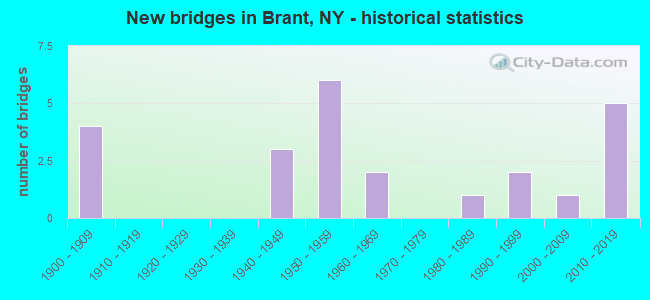
- New bridges - historical statistics
- 41900-1909
- 31940-1949
- 61950-1959
- 21960-1969
- 11980-1989
- 21990-1999
- 12000-2009
- 52010-2019


- Bridge Condition - Deck
- 28.6%Excellent
- 28.6%Good
- 14.3%Satisfactory
- 28.6%Fair

- Bridge Condition - Superstructure
- 28.6%Excellent
- 14.3%Very good
- 28.6%Good
- 28.6%Satisfactory

- Bridge Condition - Substructure
- 28.6%Excellent
- 14.3%Very good
- 14.3%Good
- 14.3%Satisfactory
- 28.6%Fair

- Bridge Condition - Channel
- 22.2%Very good
- 33.3%Good
- 11.1%Satisfactory
- 22.2%Fair
- 11.1%Poor

- Bridge Condition - Culverts
- 16.7%Excellent
- 50.0%Good
- 16.7%Fair
- 16.7%Poor
Find on map >> Show street view
Structure Number: 100135, Location: 0.8 MI NE JCT RTS 5 & 249 (Lat: 42.603256, Lng: -79.079961), Route carried "on" structure: State highway 5, Year Built: 1993, Status: Open, Structure Length: 0.73m (2.40ft), Average Daily Traffic: 5,577 (year 2018), Truck Traffic: 4%, Average Future Daily Traffic: 5,629 (year 2040), Design Load: HS 25 or greater, Features Intersected: MUDDY CREEK
Minimum Vertical Clearance: 30+ m (98+ ft), Kilometerpoint: 4.956, Lanes on structure: 4, Base Highway Network: Yes, Owner: State Highway Agency, Approaching Roadway Width: 19.8m (65.0ft), Material/Design: Concrete, Design/Construction: Culvert, Number Of Spans In Main Unit: 1, Length of Maximum Span: 7.0m (23.0ft), Curb-To-Curb Width: 20.0m (65.6ft), Out-to-Out Width: 20.7m (67.9ft)
Condition: Channel: Good, Culverts: Poor, Operating Rating: 62.6 metric tons, Method Used To Determine Operating Rating: Load Factor (LF), Inventory Rating: 35.4 metric tons, Method Used To Determine Inventory Rating: Load Factor (LF), Structural Evaluation: Meets minimum limits, Deck Geometry: Better than present minimum criteria, Waterway Adequacy: Equal to present minimum criteria, Approach Roadway Alignment: Equal to present desirable criteria, Length Of Structure Improvement: 0.73m (2.40ft), Designated Inspection Frequency: Every 24 months, Inspection Date: July 2021, Bridge Improvement Cost: $419,000, Roadway Improvement Cost: $245,000, Total Project Cost: $664,000 ( Estimate for 2021)
Find on map >> Show street view
Structure Number: 104329, Location: 0.6 MI E JCT RTS 429 +323 (Lat: 42.588400, Lng: -79.005381), Route carried "on" structure: State highway 249, Year Built: 2003, Status: Open, Structure Length: 0.76m (2.49ft), Average Daily Traffic: 884 (year 2019), Truck Traffic: 14%, Average Future Daily Traffic: 892 (year 2040), Features Intersected: DELAWARE CREEK
Minimum Vertical Clearance: 30+ m (98+ ft), Kilometerpoint: 7.257, Lanes on structure: 2, Base Highway Network: Yes, Owner: State Highway Agency, Approaching Roadway Width: 8.5m (27.9ft), Material/Design: Concrete, Design/Construction: Culvert, Number Of Spans In Main Unit: 1, Length of Maximum Span: 7.3m (24.0ft)
Condition: Channel: Very good, Culverts: Excellent, Inventory Rating: 90.7 metric tons, Method Used To Determine Inventory Rating: Load Factor (LF), Structural Evaluation: Superior to present desirable criteria, Waterway Adequacy: Equal to present minimum criteria, Approach Roadway Alignment: Equal to present desirable criteria, Length Of Structure Improvement: 0.76m (2.49ft), Designated Inspection Frequency: Every 24 months, Inspection Date: August 2021, Bridge Improvement Cost: $381,000, Roadway Improvement Cost: $223,000, Total Project Cost: $604,000 ( Estimate for 2021), Wearing Surface/Protective System: Wearing Surface: Bituminous
Find on map >> Show street view
Structure Number: 106112, Location: JCT RTS 249 + I-90 (Lat: 42.588739, Lng: -79.054383), Route carried "on" structure: State highway 249, Year Built: 1958, Status: Open, Structure Length: 10.27m (33.69ft), Average Daily Traffic: 884 (year 2019), Truck Traffic: 14%, Average Future Daily Traffic: 892 (year 2040), Design Load: HS 20, Features Intersected: 90IX EB, RTE I90
Minimum Vertical Clearance: 30+ m (98+ ft), Kilometerpoint: 3.170, Lanes on structure: 2, Lanes under structure: 4, Base Highway Network: Yes, Owner: State Toll Authority, Maintenance Responsibility: State Highway Agency, Approaching Roadway Width: 9.1m (29.9ft), Skew: 4 degrees, Material/Design: Steel, Design/Construction: Stringer/Multi-beam, Number Of Spans In Main Unit: 5, Length of Maximum Span: 24.1m (79.1ft), Curb or Sidewalk Widths: Left: 0.8m (2.6ft), Right: 0.8m (2.6ft), Curb-To-Curb Width: 7.9m (25.9ft), Out-to-Out Width: 10.1m (33.1ft)
Condition: Deck: Fair, Superstructure: Satisfactory, Substructure: Fair, Operating Rating: 60.8 metric tons, Method Used To Determine Operating Rating: Load Factor (LF), Inventory Rating: 36.3 metric tons, Method Used To Determine Inventory Rating: Load Factor (LF), Structural Evaluation: Somewhat better than minimum adequacy, Deck Geometry: Somewhat better than minimum adequacy, Underclear: High priority of corrective action, Approach Roadway Alignment: Equal to present minimum criteria, Length Of Structure Improvement: 10.27m (33.69ft), Designated Inspection Frequency: Every 24 months, Inspection Date: November 2020, Bridge Improvement Cost: $3,581,000, Roadway Improvement Cost: $2,097,000, Total Project Cost: $5,678,000 ( Estimate for 2021), Deck Structure Type: Concrete Cast-file-Place, Wearing Surface/Protective System: Wearing Surface: Bituminous, Membrane: Other
Find on map >> Show street view
Structure Number: 106113, Location: 0.7 MI W JCT RTS 249 & 62 (Lat: 42.594872, Lng: -78.953206), Route carried "on" structure: State highway 249, Year Built: 1999, Status: Open, Structure Length: 2.10m (6.89ft), Average Daily Traffic: 1,056 (year 2017), Truck Traffic: 8%, Average Future Daily Traffic: 1,066 (year 2040), Design Load: HS 25 or greater, Features Intersected: BIG SISTER CREEK
Minimum Vertical Clearance: 30+ m (98+ ft), Kilometerpoint: 12.132, Lanes on structure: 2, Base Highway Network: Yes, Owner: State Highway Agency, Approaching Roadway Width: 9.1m (29.9ft), Material/Design: Prestressed concrete, Design/Construction: Box Beam or Girders - Multiple, Number Of Spans In Main Unit: 1, Length of Maximum Span: 20.1m (65.9ft), Curb-To-Curb Width: 9.0m (29.5ft), Out-to-Out Width: 10.1m (33.1ft)
Condition: Deck: Good, Superstructure: Very good, Substructure: Very good, Channel: Good, Operating Rating: 68.9 metric tons, Method Used To Determine Operating Rating: Load Factor (LF), Inventory Rating: 40.8 metric tons, Method Used To Determine Inventory Rating: Load Factor (LF), Structural Evaluation: Equal to present desirable criteria, Deck Geometry: Somewhat better than minimum adequacy, Waterway Adequacy: Somewhat better than minimum adequacy, Approach Roadway Alignment: Equal to present desirable criteria, Length Of Structure Improvement: 2.10m (6.89ft), Designated Inspection Frequency: Every 24 months, Inspection Date: July 2021, Bridge Improvement Cost: $552,000, Roadway Improvement Cost: $323,000, Total Project Cost: $876,000 ( Estimate for 2021), Wearing Surface/Protective System: Wearing Surface: Integral Concrete
Find on map >> Show street view
Structure Number: 221289, Location: 1 MI SW OF NORTH COLLINS (Lat: 42.584464, Lng: -78.953019), Route carried "on" structure: Other road , Year Built: 1960, Year Reconstructed: 1985, Status: Open, Structure Length: 1.25m (4.10ft), Average Daily Traffic: 209 (year 2019), Truck Traffic: 5%, Average Future Daily Traffic: 293 (year 2039), Design Load: HS 20, Features Intersected: BIG SISTER CREEK, Facility Carried by Structure: HALLEY ROAD
Minimum Vertical Clearance: 30+ m (98+ ft), Kilometerpoint: 0.354, Lanes on structure: 2, Owner: Town or Township Highway Agency, Approaching Roadway Width: 6.1m (20.0ft), Skew: 3 degrees, Material/Design: Prestressed concrete, Design/Construction: Box Beam or Girders - Multiple, Number Of Spans In Main Unit: 1, Length of Maximum Span: 12.1m (39.7ft), Curb-To-Curb Width: 7.3m (24.0ft), Out-to-Out Width: 7.7m (25.3ft)
Condition: Deck: Good, Superstructure: Good, Substructure: Good, Channel: Fair, Operating Rating: 71.7 metric tons, Method Used To Determine Operating Rating: Load Factor (LF), Inventory Rating: 42.6 metric tons, Method Used To Determine Inventory Rating: Load Factor (LF), Structural Evaluation: Better than present minimum criteria, Deck Geometry: Somewhat better than minimum adequacy, Waterway Adequacy: Meets minimum limits, Approach Roadway Alignment: Equal to present desirable criteria, Length Of Structure Improvement: 1.24m (4.07ft), Designated Inspection Frequency: Every 24 months, Inspection Date: April 2020, Bridge Improvement Cost: $337,000, Roadway Improvement Cost: $197,000, Total Project Cost: $534,000 ( Estimate for 2021), Wearing Surface/Protective System: Wearing Surface: Bituminous, Membrane: Other
Find on map >> Show street view
Structure Number: 22129, Location: 0.8 MI.N.OF BRANT (Lat: 42.599150, Lng: -79.015128), Route carried "on" structure: Other road , Year Built: 1957, Status: Open, Structure Length: 0.76m (2.49ft), Average Daily Traffic: 105 (year 2016), Truck Traffic: 2%, Average Future Daily Traffic: 147 (year 2036), Features Intersected: DELAWARE CREEK, Facility Carried by Structure: ELLIS ROAD
Minimum Vertical Clearance: 30+ m (98+ ft), Kilometerpoint: 0.177, Lanes on structure: 2, Owner: Town or Township Highway Agency, Approaching Roadway Width: 7.0m (23.0ft), Skew: 2 degrees, Material/Design: Steel, Design/Construction: Culvert, Number Of Spans In Main Unit: 2, Length of Maximum Span: 3.0m (9.8ft), Curb-To-Curb Width: 8.2m (26.9ft), Out-to-Out Width: 9.7m (31.8ft)
Condition: Channel: Fair, Culverts: Fair, Operating Rating: 73.8 metric tons, Method Used To Determine Operating Rating: Field evaluation and documented engineering judgment, Inventory Rating: 19.6 metric tons, Method Used To Determine Inventory Rating: Field evaluation and documented engineering judgment, Structural Evaluation: Somewhat better than minimum adequacy, Deck Geometry: Somewhat better than minimum adequacy, Waterway Adequacy: Meets minimum limits, Approach Roadway Alignment: Equal to present desirable criteria, Length Of Structure Improvement: 0.76m (2.49ft), Designated Inspection Frequency: Every 24 months, Inspection Date: July 2020, Bridge Improvement Cost: $204,000, Roadway Improvement Cost: $119,000, Total Project Cost: $323,000 ( Estimate for 2021), Wearing Surface/Protective System: Wearing Surface: Bituminous
Find on map >> Show street view
Structure Number: 332743, Location: .7 MILE SW OF N COLLINS (Lat: 42.573881, Lng: -78.945664), Route carried "on" structure: County highway , Year Built: 1961, Status: Posted for load-capacity, Structure Length: 1.01m (3.31ft), Average Daily Traffic: 1,794 (year 2020), Truck Traffic: 10%, Average Future Daily Traffic: 2,512 (year 2040), Features Intersected: BIG SISTER CREEK, Facility Carried by Structure: MILESTRIP ROAD
Minimum Vertical Clearance: 30+ m (98+ ft), Kilometerpoint: 9.493, Lanes on structure: 2, Owner: County Highway Agency, Approaching Roadway Width: 8.5m (27.9ft), Material/Design: Concrete continuous, Design/Construction: Culvert, Number Of Spans In Main Unit: 2, Length of Maximum Span: 4.5m (14.8ft)
Condition: Channel: Good, Culverts: Good, Operating Rating: 26.9 metric tons, Method Used To Determine Operating Rating: Load and Resistance Factor Rating (LRFR) rating reported by rating factor(RF) method using HL-93 loadings, Inventory Rating: 20.7 metric tons, Method Used To Determine Inventory Rating: Load and Resistance Factor Rating (LRFR) rating reported by rating factor(RF) method using HL-93 loadings, Structural Evaluation: Somewhat better than minimum adequacy, Waterway Adequacy: Meets minimum limits, Approach Roadway Alignment: Equal to present desirable criteria, Length Of Structure Improvement: 1.00m (3.28ft), Designated Inspection Frequency: Every 24 months, Inspection Date: May 2020, Bridge Improvement Cost: $237,000, Roadway Improvement Cost: $139,000, Total Project Cost: $376,000 ( Estimate for 2021), Wearing Surface/Protective System: Wearing Surface: Bituminous
Find on map >> Show street view
Structure Number: 332783, Location: 1 MI N OF NORTH COLLINS (Lat: 42.608822, Lng: -78.946453), Route carried "on" structure: County highway , Year Built: 1955, Status: Open, Structure Length: 2.38m (7.81ft), Average Daily Traffic: 957 (year 2018), Truck Traffic: 6%, Average Future Daily Traffic: 1,340 (year 2038), Features Intersected: BIG SISTER CREEK, Facility Carried by Structure: CAIN ROAD
Minimum Vertical Clearance: 30+ m (98+ ft), Kilometerpoint: 5.792, Lanes on structure: 2, Owner: County Highway Agency, Approaching Roadway Width: 6.7m (22.0ft), Skew: 3 degrees, Material/Design: Steel, Design/Construction: Stringer/Multi-beam, Number Of Spans In Main Unit: 1, Length of Maximum Span: 23.1m (75.8ft), Curb or Sidewalk Widths: Left: 0.7m (2.3ft), Right: 0.7m (2.3ft), Curb-To-Curb Width: 7.3m (24.0ft), Out-to-Out Width: 9.1m (29.9ft)
Condition: Deck: Satisfactory, Superstructure: Good, Substructure: Satisfactory, Channel: Satisfactory, Operating Rating: 57.2 metric tons, Method Used To Determine Operating Rating: Load Factor (LF), Inventory Rating: 33.6 metric tons, Method Used To Determine Inventory Rating: Load Factor (LF), Structural Evaluation: Equal to present minimum criteria, Deck Geometry: Meets minimum limits, Waterway Adequacy: Meets minimum limits, Approach Roadway Alignment: Equal to present desirable criteria, Length Of Structure Improvement: 2.37m (7.78ft), Designated Inspection Frequency: Every 24 months, Inspection Date: July 2020, Bridge Improvement Cost: $1,405,000, Roadway Improvement Cost: $823,000, Total Project Cost: $2,228,000 ( Estimate for 2021), Deck Structure Type: Concrete Cast-file-Place, Wearing Surface/Protective System: Wearing Surface: Bituminous
Find on map >> Show street view
Structure Number: 336789, Location: 1 MILE NORTH OF BRANT (Lat: 42.600494, Lng: -79.017339), Route carried "on" structure: County highway , Year Built: 1985, Status: Open, Structure Length: 0.73m (2.40ft), Average Daily Traffic: 1,505 (year 2020), Truck Traffic: 8%, Average Future Daily Traffic: 2,107 (year 2040), Design Load: HS 20, Features Intersected: DELAWARE CREEK, Facility Carried by Structure: ANGOLA-BRANT ROAD
Minimum Vertical Clearance: 30+ m (98+ ft), Kilometerpoint: 3.717, Lanes on structure: 2, Owner: County Highway Agency, Approaching Roadway Width: 9.1m (29.9ft), Skew: 1 degrees, Material/Design: Concrete continuous, Design/Construction: Culvert, Number Of Spans In Main Unit: 2, Length of Maximum Span: 3.3m (10.8ft)
Condition: Channel: Poor, Culverts: Good, Inventory Rating: 71.7 metric tons, Method Used To Determine Inventory Rating: Load Factor (LF), Structural Evaluation: Better than present minimum criteria, Waterway Adequacy: High priority of corrective action, Approach Roadway Alignment: Equal to present desirable criteria, Length Of Structure Improvement: 0.73m (2.40ft), Designated Inspection Frequency: Every 24 months, Inspection Date: May 2020, Bridge Improvement Cost: $185,000, Roadway Improvement Cost: $108,000, Total Project Cost: $293,000 ( Estimate for 2021), Wearing Surface/Protective System: Wearing Surface: Bituminous
Find on map >> Show street view
Structure Number: 336798, Location: .4 MI W JCT US 20 & CR491 (Lat: 42.610153, Lng: -79.034250), Route carried "on" structure: County highway , Year Built: 2011, Status: Open, Structure Length: 0.76m (2.49ft), Average Daily Traffic: 282 (year 2017), Truck Traffic: 4%, Average Future Daily Traffic: 395 (year 2037), Design Load: HS 25 or greater, Features Intersected: DELAWARE CREEK, Facility Carried by Structure: CAIN ROAD
Minimum Vertical Clearance: 30+ m (98+ ft), Kilometerpoint: 3.089, Lanes on structure: 2, Owner: County Highway Agency, Approaching Roadway Width: 9.6m (31.5ft), Skew: 2 degrees, Material/Design: Concrete, Design/Construction: Culvert, Number Of Spans In Main Unit: 1, Length of Maximum Span: 7.3m (24.0ft), Curb-To-Curb Width: 9.4m (30.8ft), Out-to-Out Width: 9.8m (32.2ft)
Condition: Channel: Very good, Culverts: Good, Operating Rating: 68.7 metric tons, Method Used To Determine Operating Rating: Load and Resistance Factor Rating (LRFR) rating reported by rating factor(RF) method using HL-93 loadings, Inventory Rating: 53.1 metric tons, Method Used To Determine Inventory Rating: Load and Resistance Factor Rating (LRFR) rating reported by rating factor(RF) method using HL-93 loadings, Structural Evaluation: Better than present minimum criteria, Deck Geometry: Equal to present minimum criteria, Waterway Adequacy: Equal to present minimum criteria, Approach Roadway Alignment: Equal to present desirable criteria, Length Of Structure Improvement: 0.76m (2.49ft), Designated Inspection Frequency: Every 24 months, Inspection Date: November 2021, Bridge Improvement Cost: $360,000, Roadway Improvement Cost: $211,000, Total Project Cost: $571,000 ( Estimate for 2021)
Find on map >> Show street view
Structure Number: 551231, Location: 5.2 MI. NE OF I-90 INT 58 (Lat: 42.601239, Lng: -79.032153), Route carried "on" structure: County highway , Year Built: 1956, Status: Open, Structure Length: 10.52m (34.51ft), Average Daily Traffic: 180 (year 2016), Truck Traffic: 5%, Average Future Daily Traffic: 252 (year 2036), Design Load: HS 20+Mod, Features Intersected: 90IX WB, RTE I90, Facility Carried by Structure: CR492 HARDPAN RD
Minimum Vertical Clearance: 30+ m (98+ ft), Kilometerpoint: 1.400, Lanes on structure: 2, Lanes under structure: 4, Owner: State Toll Authority, Approaching Roadway Width: 8.5m (27.9ft), Skew: 3 degrees, Material/Design: Steel, Design/Construction: Stringer/Multi-beam, Number Of Spans In Main Unit: 5, Length of Maximum Span: 24.1m (79.1ft), Curb or Sidewalk Widths: Left: 0.8m (2.6ft), Right: 0.8m (2.6ft), Curb-To-Curb Width: 7.9m (25.9ft), Out-to-Out Width: 10.1m (33.1ft)
Condition: Deck: Fair, Superstructure: Satisfactory, Substructure: Fair, Operating Rating: 68.9 metric tons, Method Used To Determine Operating Rating: Load Factor (LF), Inventory Rating: 40.8 metric tons, Method Used To Determine Inventory Rating: Load Factor (LF), Structural Evaluation: Somewhat better than minimum adequacy, Deck Geometry: Somewhat better than minimum adequacy, Underclear: High priority of corrective action, Approach Roadway Alignment: Equal to present desirable criteria, Length Of Structure Improvement: 10.51m (34.48ft), Designated Inspection Frequency: Every 24 months, Inspection Date: October 2020, Bridge Improvement Cost: $3,656,000, Roadway Improvement Cost: $2,141,000, Total Project Cost: $5,798,000 ( Estimate for 2021), Deck Structure Type: Concrete Cast-file-Place, Wearing Surface/Protective System: Wearing Surface: Bituminous
Find on map >> Show street view
Structure Number: 60485, Location: JCT RT 438 + I-90 (Lat: 42.564656, Lng: -79.091917), Route carried "on" structure: State highway 438, Year Built: 2015, Status: Open, Structure Length: 5.15m (16.90ft), Average Daily Traffic: 2,990 (year 2020), Truck Traffic: 7%, Average Future Daily Traffic: 3,019 (year 2040), Design Load: HL 93, Features Intersected: 90IX EB, RTE I90
Minimum Vertical Clearance: 30+ m (98+ ft), Kilometerpoint: 17.940, Lanes on structure: 2, Lanes under structure: 4, Base Highway Network: Yes, Owner: State Toll Authority, Approaching Roadway Width: 9.1m (29.9ft), Material/Design: Steel, Design/Construction: Stringer/Multi-beam, Number Of Spans In Main Unit: 2, Length of Maximum Span: 25.6m (84.0ft), Curb or Sidewalk Widths: Left: 1.8m (5.9ft), Right: 1.8m (5.9ft), Curb-To-Curb Width: 9.1m (29.9ft), Out-to-Out Width: 13.3m (43.6ft)
Condition: Deck: Excellent, Superstructure: Excellent, Substructure: Excellent, Operating Rating: 35.6 metric tons, Method Used To Determine Operating Rating: Load and Resistance Factor Rating (LRFR) rating reported by rating factor(RF) method using HL-93 loadings, Inventory Rating: 27.5 metric tons, Method Used To Determine Inventory Rating: Load and Resistance Factor Rating (LRFR) rating reported by rating factor(RF) method using HL-93 loadings, Structural Evaluation: Equal to present minimum criteria, Deck Geometry: Meets minimum limits, Underclear: High priority of corrective action, Approach Roadway Alignment: Equal to present desirable criteria, Length Of Structure Improvement: 5.15m (16.90ft), Designated Inspection Frequency: Every 24 months, Inspection Date: August 2021, Bridge Improvement Cost: $2,991,000, Roadway Improvement Cost: $1,751,000, Total Project Cost: $4,742,000 ( Estimate for 2021), Deck Structure Type: Concrete Cast-file-Place, Wearing Surface/Protective System: Wearing Surface: Integral Concrete, Deck Protection: Galvanized Reinforcing
Find on map >> Show street view
Structure Number: 660003, Location: 2.1 MI. NE OF I-90 INT 58 (Lat: 42.573969, Lng: -79.080417), Route carried "on" structure: Other road , Year Built: 2015, Status: Open, Structure Length: 11.67m (38.29ft), Average Daily Traffic: 1,052 (year 2016), Truck Traffic: 8%, Average Future Daily Traffic: 1,473 (year 2036), Design Load: HS 25 or greater, Features Intersected: 90IX EB, RTE I90, Facility Carried by Structure: MILESTRIP RD
Minimum Vertical Clearance: 30+ m (98+ ft), Kilometerpoint: 2.590, Lanes on structure: 2, Lanes under structure: 4, Owner: State Toll Authority, Approaching Roadway Width: 9.1m (29.9ft), Material/Design: Steel, Design/Construction: Stringer/Multi-beam, Number Of Spans In Main Unit: 2, Length of Maximum Span: 57.6m (189.0ft), Curb or Sidewalk Widths: Left: 1.8m (5.9ft), Right: 1.8m (5.9ft), Curb-To-Curb Width: 9.1m (29.9ft), Out-to-Out Width: 13.3m (43.6ft)
Condition: Deck: Excellent, Superstructure: Excellent, Substructure: Excellent, Operating Rating: 50.2 metric tons, Method Used To Determine Operating Rating: Load and Resistance Factor Rating (LRFR) rating reported by rating factor(RF) method using HL-93 loadings, Inventory Rating: 38.6 metric tons, Method Used To Determine Inventory Rating: Load and Resistance Factor Rating (LRFR) rating reported by rating factor(RF) method using HL-93 loadings, Structural Evaluation: Superior to present desirable criteria, Deck Geometry: Somewhat better than minimum adequacy, Underclear: Meets minimum limits, Approach Roadway Alignment: Equal to present desirable criteria, Length Of Structure Improvement: 11.67m (38.29ft), Designated Inspection Frequency: Every 24 months, Inspection Date: August 2021, Bridge Improvement Cost: $5,967,000, Roadway Improvement Cost: $3,494,000, Total Project Cost: $9,462,000 ( Estimate for 2021), Deck Structure Type: Concrete Cast-file-Place, Wearing Surface/Protective System: Wearing Surface: Integral Concrete, Deck Protection: Galvanized Reinforcing
Find on map >> Show street view
Structure Number: 106112, Location: JCT RTS 249 + I-90 (Lat: 42.588739, Lng: -79.054383), Route carried "under" structure: Interstate 90, Year Built: 1958, Structure Length: 0. m, Average Daily Traffic: 23,662 (year 2015), Features Intersected: 90IX EB, RTE I90, Facility Carried by Structure: RTE 249
Minimum Vertical Clearance: 4.67m (15.32ft), Kilometerpoint: 726.898, Lanes on structure: 2, Lanes under structure: 2, Toll: On Interstate toll segment, Material/Design: Steel, Design/Construction: Stringer/Multi-beam, Length of Maximum Span: 24.1m (79.1ft)
Find on map >> Show street view
Structure Number: 551231, Location: 5.2 MI. NE OF I-90 INT 58 (Lat: 42.601239, Lng: -79.032153), Route carried "under" structure: Interstate 90, Year Built: 1956, Structure Length: 0. m, Average Daily Traffic: 13,500 (year 1977), Features Intersected: 90IX WB, RTE I90, Facility Carried by Structure: CR492 HARDPAN RD
Minimum Vertical Clearance: 4.98m (16.34ft), Kilometerpoint: 724.517, Lanes on structure: 2, Lanes under structure: 2, Toll: On Interstate toll segment, Material/Design: Steel, Design/Construction: Stringer/Multi-beam, Length of Maximum Span: 24.1m (79.1ft)
Find on map >> Show street view
Structure Number: 6001331, Location: 0.6 MI N JCT RTS 5 + 20 (Lat: 42.576694, Lng: -79.105097), Route carried "under" structure: State highway 5, Year Built: 1941, Structure Length: 0. m, Average Daily Traffic: 6,264 (year 1999), Features Intersected: RTE 5, Facility Carried by Structure: NORFOLK SOUTHERN
Minimum Vertical Clearance: 4.17m (13.68ft), Kilometerpoint: 1.142, Lanes under structure: 4, Material/Design: Steel, Design/Construction: Stringer/Multi-beam, Length of Maximum Span: 16.7m (54.8ft)
Find on map >> Show street view
Structure Number: 6001332, Location: .6 MI N JCT SH 5 & US 20 (Lat: 42.576578, Lng: -79.105108), Route carried "under" structure: State highway 5, Year Built: 1941, Structure Length: 0. m, Average Daily Traffic: 6,264 (year 1999), Features Intersected: RTE 5, Facility Carried by Structure: CSX TRANS SERV RD
Minimum Vertical Clearance: 4.17m (13.68ft), Kilometerpoint: 1.142, Lanes under structure: 4, Material/Design: Steel, Design/Construction: Stringer/Multi-beam, Length of Maximum Span: 16.7m (54.8ft)
Find on map >> Show street view
Structure Number: 600134, Location: 0.6 MI N JCT RTS 5 + 20 (Lat: 42.577536, Lng: -79.105833), Route carried "under" structure: State highway 5, Year Built: 1941, Structure Length: 0. m, Average Daily Traffic: 6,264 (year 1999), Features Intersected: RTE 5, Facility Carried by Structure: CSX TRANSPRTATION
Minimum Vertical Clearance: 4.22m (13.85ft), Kilometerpoint: 1.239, Lanes under structure: 4, Material/Design: Steel, Design/Construction: Stringer/Multi-beam, Length of Maximum Span: 16.7m (54.8ft)
Find on map >> Show street view
Structure Number: 60485, Location: JCT RT 438 + I-90 (Lat: 42.564656, Lng: -79.091917), Route carried "under" structure: Interstate 90, Year Built: 2015, Structure Length: 0. m, Average Daily Traffic: 17,100 (year 1988), Features Intersected: 90IX EB, RTE I90, Facility Carried by Structure: RTE 438
Minimum Vertical Clearance: 5.18m (16.99ft), Kilometerpoint: 730.985, Lanes on structure: 2, Lanes under structure: 2, Toll: On Interstate toll segment, Material/Design: Steel, Design/Construction: Stringer/Multi-beam, Length of Maximum Span: 25.6m (84.0ft)
Find on map >> Show street view
Structure Number: 6600021, Location: CATTARAUGUS INDIAN RESERV (Lat: 42.571939, Lng: -79.113572), Route carried "under" structure: Other road , Year Built: 1908, Structure Length: 0. m, Average Daily Traffic: 20 (year 2021), Features Intersected: ERIE ROAD, Facility Carried by Structure: ABANDONED CSX TRK
Minimum Vertical Clearance: 4.24m (13.91ft), Kilometerpoint: 1.094, Lanes under structure: 2, Material/Design: Steel, Design/Construction: Stringer/Multi-beam, Length of Maximum Span: 8.8m (28.9ft)
Find on map >> Show street view
Structure Number: 6600022, Location: CATTARAUGUS INDIAN RESERV (Lat: 42.571922, Lng: -79.113542), Route carried "under" structure: Other road , Year Built: 1908, Structure Length: 0. m, Average Daily Traffic: 20 (year 2021), Features Intersected: ERIE ROAD, Facility Carried by Structure: CSX TRANSPRTATION
Minimum Vertical Clearance: 4.29m (14.07ft), Kilometerpoint: 1.094, Lanes under structure: 2, Material/Design: Steel, Design/Construction: Stringer/Multi-beam, Length of Maximum Span: 8.8m (28.9ft)
Find on map >> Show street view
Structure Number: 6600023, Location: CATTARAUGUS INDIAN RESERV (Lat: 42.571886, Lng: -79.113497), Route carried "under" structure: Other road , Year Built: 1908, Structure Length: 0. m, Average Daily Traffic: 20 (year 2021), Features Intersected: ERIE ROAD, Facility Carried by Structure: CSX TRANSPRTATION
Minimum Vertical Clearance: 4.50m (14.76ft), Kilometerpoint: 1.094, Lanes under structure: 2, Material/Design: Steel, Design/Construction: Stringer/Multi-beam, Length of Maximum Span: 8.8m (28.9ft)
Find on map >> Show street view
Structure Number: 6600024, Location: CATTARAUGUS INDIAN RESERV (Lat: 42.571864, Lng: -79.113469), Route carried "under" structure: Other road , Year Built: 1908, Structure Length: 0. m, Average Daily Traffic: 20 (year 2021), Features Intersected: ERIE ROAD, Facility Carried by Structure: CSX TRANS SERV RD
Minimum Vertical Clearance: 4.19m (13.75ft), Kilometerpoint: 1.094, Lanes under structure: 2, Material/Design: Steel, Design/Construction: Stringer/Multi-beam, Length of Maximum Span: 8.8m (28.9ft)
Find on map >> Show street view
Structure Number: 660003, Location: 2.1 MI. NE OF I-90 INT 58 (Lat: 42.573969, Lng: -79.080417), Route carried "under" structure: Interstate 90, Year Built: 2015, Structure Length: 0. m, Average Daily Traffic: 13,500 (year 1977), Features Intersected: 90IX EB, RTE I90, Facility Carried by Structure: MILESTRIP RD
Minimum Vertical Clearance: 5.26m (17.26ft), Kilometerpoint: 729.617, Lanes on structure: 2, Lanes under structure: 2, Toll: On Interstate toll segment, Material/Design: Steel, Design/Construction: Stringer/Multi-beam, Length of Maximum Span: 57.6m (189.0ft)