Bridge Statistics for Bolton, Connecticut (CT)
Condition, Traffic, Stress, Structural Evaluation, Project Costs
- National Bridge Inventory (NBI) Statistics
- 13Number of bridges
- 79ft / 24.0mTotal length
- 349,129Total average daily traffic
- 30,282Total average daily truck traffic
- National Bridge Inventory (NBI) Registered Bridges for Bolton
- No street view available for this location
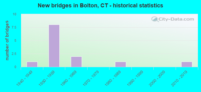
- New bridges - historical statistics
- 11940-1949
- 81950-1959
- 21960-1969
- 11980-1989
- 12010-2019

- Reconstructed bridges - Historical Statistics
- 11980-1989
- 21990-1999
- 12000-2009


- Bridge Condition - Deck
- 40.0%Good
- 40.0%Satisfactory
- 20.0%Fair

- Bridge Condition - Superstructure
- 33.3%Good
- 33.3%Satisfactory
- 33.3%Fair

- Bridge Condition - Substructure
- 16.7%Good
- 83.3%Satisfactory

- Bridge Condition - Channel
- 50.0%Satisfactory
- 25.0%Fair
- 25.0%Poor

- Bridge Condition - Culverts
- 33.3%Good
- 33.3%Satisfactory
- 33.3%Fair
Find on map >> Show street view
Structure Number: 67, Location: 1.3 MI N. OF ROUTE 136 (Lat: 41.123097, Lng: -73.345997), Route carried "on" structure: City street , Year Built: 1958, Status: Open, Structure Length: 5.61m (18.41ft), Average Daily Traffic: 4,100 (year 2017), Truck Traffic: 4%, Average Future Daily Traffic: 6,092 (year 2037), Design Load: HS 20, Features Intersected: INTERSTATE-95, Facility Carried by Structure: HILLS POINT ROAD
Minimum Vertical Clearance: 30+ m (98+ ft), Kilometerpoint: 1.674, Lanes on structure: 2, Lanes under structure: 6, Owner: State Highway Agency, Approaching Roadway Width: 7.6m (24.9ft), Skew: 2 degrees, Material/Design: Steel, Design/Construction: Stringer/Multi-beam, Number Of Spans In Main Unit: 2, Length of Maximum Span: 27.4m (89.9ft), Curb or Sidewalk Widths: Left: 1.5m (4.9ft), Right: 0.5m (1.6ft), Curb-To-Curb Width: 13.7m (44.9ft), Out-to-Out Width: 16.5m (54.1ft)
Condition: Deck: Satisfactory, Superstructure: Fair, Substructure: Satisfactory, Operating Rating: 43.7 metric tons, Method Used To Determine Operating Rating: Load and Resistance Factor Rating (LRFR) rating reported by rating factor(RF) method using HL-93 loadings, Inventory Rating: 33.7 metric tons, Method Used To Determine Inventory Rating: Load and Resistance Factor Rating (LRFR) rating reported by rating factor(RF) method using HL-93 loadings, Structural Evaluation: Somewhat better than minimum adequacy, Deck Geometry: Superior to present desirable criteria, Underclear: High priority of corrective action, Approach Roadway Alignment: Equal to present minimum criteria, Designated Inspection Frequency: Every 24 months, Inspection Date: September 2020, Deck Structure Type: Concrete Cast-file-Place, Wearing Surface/Protective System: Wearing Surface: Bituminous, Membrane: Preformed Fabric
Find on map >> Show street view
Structure Number: 98, Location: I-95 VICINITY EXIT 25 (Lat: 41.167744, Lng: -73.221272), Route carried "on" structure: Interstate 95, Year Built: 1959, Year Reconstructed: 2005, Status: Open, Structure Length: 5.09m (16.70ft), Average Daily Traffic: 130,700 (year 2017), Truck Traffic: 9%, Average Future Daily Traffic: 194,207 (year 2037), Design Load: HS 20, Features Intersected: COMMERCE DRIVE
Minimum Vertical Clearance: 30+ m (98+ ft), Kilometerpoint: 44.144, Lanes on structure: 6, Lanes under structure: 2, Base Highway Network: Yes, Owner: State Highway Agency, Approaching Roadway Width: 46.9m (153.9ft), Skew: 35 degrees, Material/Design: Steel, Design/Construction: Stringer/Multi-beam, Number Of Spans In Main Unit: 1, Length of Maximum Span: 46.6m (152.9ft), Curb-To-Curb Width: 47.0m (154.2ft), Out-to-Out Width: 50.0m (164.0ft)
Condition: Deck: Good, Superstructure: Good, Substructure: Satisfactory, Inventory Rating: 71.0 metric tons, Method Used To Determine Inventory Rating: Load Factor (LF), Structural Evaluation: Equal to present minimum criteria, Deck Geometry: Superior to present desirable criteria, Underclear: Superior to present desirable criteria, Approach Roadway Alignment: Equal to present desirable criteria, Designated Inspection Frequency: Every 24 months, Inspection Date: October 2020, Deck Structure Type: Concrete Cast-file-Place, Wearing Surface/Protective System: Wearing Surface: Bituminous, Membrane: Built-up, Deck Protection: Epoxy Coated Reinforcing
Find on map >> Show street view
Structure Number: 269, Location: 1 MILE NORTH OF ROUTE 2A (Lat: 41.500956, Lng: -72.115581), Route carried "on" structure: Interstate 395, Year Built: 1958, Status: Open, Structure Length: 0.73m (2.40ft), Average Daily Traffic: 62,600 (year 2017), Truck Traffic: 9%, Average Future Daily Traffic: 93,017 (year 2037), Features Intersected: TRADING COVE BROOK
Minimum Vertical Clearance: 30+ m (98+ ft), Kilometerpoint: 16.834, Lanes on structure: 4, Base Highway Network: Yes, Owner: State Highway Agency, Approaching Roadway Width: 29.9m (98.1ft), Skew: 22 degrees, Material/Design: Concrete continuous, Design/Construction: Culvert, Number Of Spans In Main Unit: 3, Length of Maximum Span: 2.1m (6.9ft)
Condition: Channel: Fair, Culverts: Satisfactory, Structural Evaluation: Equal to present minimum criteria, Waterway Adequacy: Equal to present minimum criteria, Approach Roadway Alignment: Equal to present desirable criteria, Designated Inspection Frequency: Every 24 months, Inspection Date: December 2020
Find on map >> Show street view
Structure Number: 484, Location: BOLTON NOTCH (Lat: 41.789708, Lng: -72.447392), Route carried "on" structure: US 6, Year Built: 1951, Status: Open, Structure Length: 3.41m (11.19ft), Average Daily Traffic: 35,500 (year 2017), Truck Traffic: 8%, Average Future Daily Traffic: 52,749 (year 2037), Design Load: HS 20, Features Intersected: ABANDONED RAILROAD
Minimum Vertical Clearance: 30+ m (98+ ft), Kilometerpoint: 123.726, Lanes on structure: 4, Base Highway Network: Yes, Owner: State Highway Agency, Approaching Roadway Width: 20.7m (67.9ft), Skew: 36 degrees, Material/Design: Concrete, Design/Construction: Arch - Deck, Number Of Spans In Main Unit: 1, Length of Maximum Span: 12.3m (40.4ft), Curb-To-Curb Width: 20.7m (67.9ft), Out-to-Out Width: 20.7m (67.9ft)
Condition: Superstructure: Satisfactory, Substructure: Satisfactory, Operating Rating: 52.6 metric tons, Method Used To Determine Operating Rating: No rating analysis performed, Inventory Rating: 30.8 metric tons, Method Used To Determine Inventory Rating: No rating analysis performed, Structural Evaluation: Equal to present minimum criteria, Deck Geometry: Equal to present minimum criteria, Approach Roadway Alignment: Equal to present desirable criteria, Designated Inspection Frequency: Every 24 months, Inspection Date: March 2021, Wearing Surface/Protective System: Wearing Surface: Bituminous, Membrane: Preformed Fabric
Find on map >> Show street view
Structure Number: 485, Location: 1/4 M E OF INTERSTATE 384 (Lat: 41.790006, Lng: -72.443992), Route carried "on" structure: US 6, Year Built: 1952, Year Reconstructed: 1998, Status: Open, Structure Length: 3.78m (12.40ft), Average Daily Traffic: 18,200 (year 2017), Truck Traffic: 3%, Average Future Daily Traffic: 27,043 (year 2037), Design Load: HS 20, Features Intersected: US ROUTE 44 EASTBOUND
Minimum Vertical Clearance: 30+ m (98+ ft), Kilometerpoint: 123.952, Lanes on structure: 1, Lanes under structure: 1, Base Highway Network: Yes, Owner: State Highway Agency, Approaching Roadway Width: 9.8m (32.2ft), Skew: 1 degrees, Material/Design: Steel, Design/Construction: Stringer/Multi-beam, Number Of Spans In Main Unit: 3, Length of Maximum Span: 14.3m (46.9ft), Curb-To-Curb Width: 9.8m (32.2ft), Out-to-Out Width: 11.6m (38.1ft)
Condition: Deck: Satisfactory, Superstructure: Fair, Substructure: Satisfactory, Operating Rating: 35.6 metric tons, Method Used To Determine Operating Rating: Load and Resistance Factor Rating (LRFR) rating reported by rating factor(RF) method using HL-93 loadings, Inventory Rating: 27.5 metric tons, Method Used To Determine Inventory Rating: Load and Resistance Factor Rating (LRFR) rating reported by rating factor(RF) method using HL-93 loadings, Structural Evaluation: Somewhat better than minimum adequacy, Deck Geometry: Meets minimum limits, Underclear: Somewhat better than minimum adequacy, Approach Roadway Alignment: Equal to present minimum criteria, Designated Inspection Frequency: Every 24 months, Inspection Date: July 2020, Deck Structure Type: Concrete Cast-file-Place, Wearing Surface/Protective System: Wearing Surface: Bituminous
Find on map >> Show street view
Structure Number: 4137, Location: 25' SOUTH OF RTE 6 & 44 (Lat: 41.789653, Lng: -72.446200), Route carried "on" structure: City street , Year Built: 1951, Year Reconstructed: 1997, Status: Open, Structure Length: 1.92m (6.30ft), Average Daily Traffic: 1,183 (year 2016), Truck Traffic: 7%, Average Future Daily Traffic: 1,758 (year 2036), Features Intersected: DEP TRAIL ABANDONED RR, Facility Carried by Structure: NOTCH ROAD
Minimum Vertical Clearance: 30+ m (98+ ft), Kilometerpoint: 0.274, Lanes on structure: 2, Maintenance Responsibility: State Highway Agency, Approaching Roadway Width: 7.3m (24.0ft), Material/Design: Steel, Design/Construction: Stringer/Multi-beam, Number Of Spans In Main Unit: 1, Length of Maximum Span: 17.7m (58.1ft), Curb or Sidewalk Widths: Left: 0.8m (2.6ft), Right: 0.8m (2.6ft), Curb-To-Curb Width: 7.3m (24.0ft), Out-to-Out Width: 10.1m (33.1ft)
Condition: Deck: Fair, Superstructure: Satisfactory, Substructure: Satisfactory, Operating Rating: 33.7 metric tons, Method Used To Determine Operating Rating: Load and Resistance Factor Rating (LRFR) rating reported by rating factor(RF) method using HL-93 loadings, Inventory Rating: 25.9 metric tons, Method Used To Determine Inventory Rating: Load and Resistance Factor Rating (LRFR) rating reported by rating factor(RF) method using HL-93 loadings, Structural Evaluation: Equal to present minimum criteria, Deck Geometry: Meets minimum limits, Approach Roadway Alignment: High priority of corrective action, Designated Inspection Frequency: Every 24 months, Inspection Date: November 2020, Deck Structure Type: Concrete Cast-file-Place, Wearing Surface/Protective System: Wearing Surface: Bituminous, Membrane: Built-up
Find on map >> Show street view
Structure Number: 4886, Location: 1 TENTH NORTH OF ROUTE 63 (Lat: 41.332883, Lng: -72.974097), Route carried "on" structure: City street , Year Built: 1951, Year Reconstructed: 1988, Status: Open, Structure Length: 2.16m (7.09ft), Average Daily Traffic: 4,326 (year 2018), Truck Traffic: 2%, Average Future Daily Traffic: 6,428 (year 2038), Features Intersected: WEST RIVER, Facility Carried by Structure: EAST RAMSDELL ST
Minimum Vertical Clearance: 30+ m (98+ ft), Kilometerpoint: 0.064, Lanes on structure: 2, Owner: City or Municipal Highway Agency, Approaching Roadway Width: 12.8m (42.0ft), Skew: 4 degrees, Material/Design: Concrete, Design/Construction: Culvert, Number Of Spans In Main Unit: 4, Length of Maximum Span: 5.2m (17.1ft), Curb or Sidewalk Widths: Left: 4.0m (13.1ft), Right: 3.9m (12.8ft), Curb-To-Curb Width: 12.8m (42.0ft), Out-to-Out Width: 21.3m (69.9ft)
Condition: Channel: Poor, Culverts: Fair, Operating Rating: 42.6 metric tons, Method Used To Determine Operating Rating: Field evaluation and documented engineering judgment, Inventory Rating: 32.7 metric tons, Method Used To Determine Inventory Rating: Field evaluation and documented engineering judgment, Structural Evaluation: Somewhat better than minimum adequacy, Deck Geometry: Equal to present minimum criteria, Waterway Adequacy: Equal to present desirable criteria, Approach Roadway Alignment: Equal to present desirable criteria, Designated Inspection Frequency: Every 24 months, Inspection Date: June 2021, Deck Structure Type: Other, Wearing Surface/Protective System: Wearing Surface: Bituminous
Find on map >> Show street view
Structure Number: 5611, Location: 1.0 MI EAST OF HEBRON RD (Lat: 41.738717, Lng: -72.406606), Route carried "on" structure: City street , Year Built: 1947, Status: Open, Structure Length: 0.67m (2.20ft), Average Daily Traffic: 520 (year 2018), Truck Traffic: 7%, Average Future Daily Traffic: 773 (year 2038), Features Intersected: BURNAP BROOK, Facility Carried by Structure: SHODDY MILL ROAD
Minimum Vertical Clearance: 30+ m (98+ ft), Kilometerpoint: 0.000, Lanes on structure: 2, Owner: Town or Township Highway Agency, Approaching Roadway Width: 5.5m (18.0ft), Material/Design: Concrete, Design/Construction: Slab, Number Of Spans In Main Unit: 1, Length of Maximum Span: 6.1m (20.0ft), Curb or Sidewalk Widths: Left: 0.3m (1.0ft), Right: 0.3m (1.0ft), Curb-To-Curb Width: 4.9m (16.1ft), Out-to-Out Width: 5.5m (18.0ft)
Condition: Deck: Good, Superstructure: Good, Substructure: Good, Channel: Satisfactory, Operating Rating: 52.6 metric tons, Method Used To Determine Operating Rating: Field evaluation and documented engineering judgment, Inventory Rating: 30.8 metric tons, Method Used To Determine Inventory Rating: Field evaluation and documented engineering judgment, Structural Evaluation: Better than present minimum criteria, Deck Geometry: High priority of replacement, Waterway Adequacy: Better than present minimum criteria, Approach Roadway Alignment: Better than present minimum criteria, Designated Inspection Frequency: Every 24 months, Inspection Date: October 2020, Deck Structure Type: Concrete Cast-file-Place, Wearing Surface/Protective System: Wearing Surface: Bituminous, Membrane: Built-up
Find on map >> Show street view
Structure Number: 5771, Location: 0.3 MI W OF COVENTRY TL (Lat: 41.796833, Lng: -72.424603), Route carried "on" structure: US 44, Year Built: 1989, Status: Open, Structure Length: 0.64m (2.10ft), Average Daily Traffic: 17,600 (year 2015), Truck Traffic: 4%, Average Future Daily Traffic: 26,152 (year 2035), Features Intersected: BOLTON POND BROOK
Minimum Vertical Clearance: 30+ m (98+ ft), Kilometerpoint: 108.727, Lanes on structure: 2, Base Highway Network: Yes, Owner: State Highway Agency, Approaching Roadway Width: 10.1m (33.1ft), Skew: 3 degrees, Material/Design: Concrete, Design/Construction: Culvert, Number Of Spans In Main Unit: 2, Length of Maximum Span: 3.0m (9.8ft)
Condition: Channel: Satisfactory, Culverts: Good, Operating Rating: 42.6 metric tons, Method Used To Determine Operating Rating: Field evaluation and documented engineering judgment, Inventory Rating: 32.7 metric tons, Method Used To Determine Inventory Rating: Field evaluation and documented engineering judgment, Structural Evaluation: Better than present minimum criteria, Waterway Adequacy: Equal to present desirable criteria, Approach Roadway Alignment: Equal to present desirable criteria, Designated Inspection Frequency: Every 24 months, Inspection Date: November 2020, Wearing Surface/Protective System: Membrane: Built-up
Find on map >> Show street view
Structure Number: 485, Location: 1/4 M E OF INTERSTATE 384 (Lat: 41.790006, Lng: -72.443992), Route carried "under" structure: US 44, Year Built: 1952, Structure Length: 0. m, Average Daily Traffic: 16,900 (year 2017), Truck Traffic: 3%, Features Intersected: US ROUTE 44 EASTBOUND, Facility Carried by Structure: US ROUTE 6 WB
Minimum Vertical Clearance: 4.52m (14.83ft), Kilometerpoint: 106.860, Lanes on structure: 1, Lanes under structure: 1, Material/Design: Steel, Design/Construction: Stringer/Multi-beam, Length of Maximum Span: 14.3m (46.9ft)
Find on map >> Show street view
Structure Number: 3598, Location: 0.5 MI SOUTH OF ROUTE 44 (Lat: 41.778719, Lng: -72.462303), Route carried "under" structure: Interstate 384, Year Built: 1968, Structure Length: 0. m, Average Daily Traffic: 26,400 (year 2018), Truck Traffic: 14%, Features Intersected: INTERSTATE-384, Facility Carried by Structure: ROUTE 85
Minimum Vertical Clearance: 5.56m (18.24ft), Kilometerpoint: 12.328, Lanes on structure: 2, Lanes under structure: 4, Material/Design: Prestressed concrete, Design/Construction: Stringer/Multi-beam, Length of Maximum Span: 31.7m (104.0ft)
Find on map >> Show street view
Structure Number: 3599, Location: 0.5 MI WEST JCT ROUTE 44 (Lat: 41.785489, Lng: -72.454272), Route carried "under" structure: Interstate 384, Year Built: 1968, Structure Length: 0. m, Average Daily Traffic: 26,400 (year 2018), Truck Traffic: 16%, Features Intersected: INTERSTATE 384, Facility Carried by Structure: US ROUTE 6 & 44 EB
Minimum Vertical Clearance: 5.28m (17.32ft), Kilometerpoint: 13.341, Lanes on structure: 1, Lanes under structure: 4, Material/Design: Steel continuous, Design/Construction: Stringer/Multi-beam, Length of Maximum Span: 41.1m (134.8ft)
Find on map >> Show street view
Structure Number: 6886, Location: 0.9 MILES E.OF BOLTON TL (Lat: 41.786389, Lng: -72.454161), Route carried "under" structure: US 6, Year Built: 2017, Structure Length: 0. m, Average Daily Traffic: 4,700 (year 2017), Features Intersected: U.S. ROUTES 6 & 44 WB, Facility Carried by Structure: CHARTER OAK GREENW
Minimum Vertical Clearance: 5.44m (17.85ft), Kilometerpoint: 123.115, Lanes under structure: 1, Material/Design: Steel, Design/Construction: Truss - Thru, Length of Maximum Span: 43.5m (142.7ft)