Bridge Statistics for Blossom, Texas (TX)
Condition, Traffic, Stress, Structural Evaluation, Project Costs
- National Bridge Inventory (NBI) Statistics
- 13Number of bridges
- 43ft / 12.8mTotal length
- $12,000Total costs
- 30,390Total average daily traffic
- 4,499Total average daily truck traffic
- 41,806Total future (year 2030) average daily traffic
- National Bridge Inventory (NBI) Registered Bridges for Blossom
- No street view available for this location
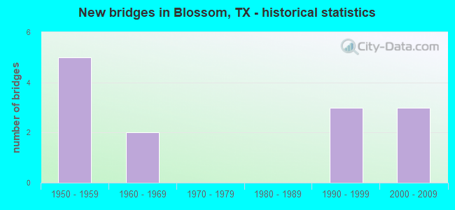
- New bridges - historical statistics
- 51950-1959
- 21960-1969
- 31990-1999
- 32000-2009


- Bridge Condition - Deck
- 50.0%Very good
- 50.0%Good

- Bridge Condition - Substructure
- 50.0%Good
- 50.0%Satisfactory

- Bridge Condition - Channel
- 38.5%Good
- 46.2%Satisfactory
- 15.4%Fair

- Bridge Condition - Culverts
- 54.5%Good
- 36.4%Satisfactory
- 9.1%Serious
Find on map >> Show street view
Structure Number: 11390004509084, Location: 5.5 MI E OF US 271 (Lat: 33.662872, Lng: -95.415236), Route carried "on" structure: US 82, Year Built: 1950, Year Reconstructed: 2011, Status: Open, Structure Length: 0.67m (2.20ft), Average Daily Traffic: 9,490 (year 2020), Truck Traffic: 18%, Average Future Daily Traffic: 13,619 (year 2039), Design Load: H 15, Features Intersected: MULBERRY CREEK BRANCH
Minimum Vertical Clearance: 30+ m (98+ ft), Kilometerpoint: 26.553, Lanes on structure: 5, Base Highway Network: Yes, Owner: State Highway Agency, Approaching Roadway Width: 25.0m (82.0ft), Material/Design: Concrete, Design/Construction: Culvert, Number Of Spans In Main Unit: 4, Length of Maximum Span: 1.5m (4.9ft)
Condition: Channel: Good, Culverts: Good, Operating Rating: 39.9 metric tons, Method Used To Determine Operating Rating: Load Factor (LF), Inventory Rating: 23.6 metric tons, Method Used To Determine Inventory Rating: Load Factor (LF), Structural Evaluation: Somewhat better than minimum adequacy, Waterway Adequacy: Equal to present minimum criteria, Approach Roadway Alignment: Equal to present desirable criteria, Designated Inspection Frequency: Every 24 months, Inspection Date: December 2020
Find on map >> Show street view
Structure Number: 11390004509085, Location: 6.0 MI E OF US 271 (Lat: 33.662386, Lng: -95.404858), Route carried "on" structure: US 82, Year Built: 1950, Year Reconstructed: 2011, Status: Open, Structure Length: 0.82m (2.69ft), Average Daily Traffic: 9,490 (year 2020), Truck Traffic: 18%, Average Future Daily Traffic: 13,619 (year 2039), Design Load: H 15, Features Intersected: MULBERRY CREEK BRANCH
Minimum Vertical Clearance: 30+ m (98+ ft), Kilometerpoint: 27.497, Lanes on structure: 5, Base Highway Network: Yes, Owner: State Highway Agency, Approaching Roadway Width: 25.0m (82.0ft), Skew: 4 degrees, Material/Design: Concrete, Design/Construction: Culvert, Number Of Spans In Main Unit: 3, Length of Maximum Span: 1.8m (5.9ft)
Condition: Channel: Good, Culverts: Good, Operating Rating: 39.9 metric tons, Method Used To Determine Operating Rating: Load Factor (LF), Inventory Rating: 23.6 metric tons, Method Used To Determine Inventory Rating: Load Factor (LF), Structural Evaluation: Somewhat better than minimum adequacy, Waterway Adequacy: Equal to present minimum criteria, Approach Roadway Alignment: Equal to present desirable criteria, Designated Inspection Frequency: Every 24 months, Inspection Date: December 2020
Find on map >> Show street view
Structure Number: 11390004511086, Location: 0.2 MI E OF FM 196 (Lat: 33.662336, Lng: -95.375753), Route carried "on" structure: US 82, Year Built: 1950, Status: Open, Structure Length: 1.10m (3.61ft), Average Daily Traffic: 6,781 (year 2020), Truck Traffic: 13%, Average Future Daily Traffic: 8,736 (year 2039), Design Load: H 15, Features Intersected: CUTHAND CREEK
Minimum Vertical Clearance: 30+ m (98+ ft), Kilometerpoint: 30.273, Lanes on structure: 2, Base Highway Network: Yes, Owner: State Highway Agency, Approaching Roadway Width: 13.7m (44.9ft), Skew: 4 degrees, Material/Design: Concrete, Design/Construction: Culvert, Number Of Spans In Main Unit: 3, Length of Maximum Span: 2.4m (7.9ft)
Condition: Channel: Satisfactory, Culverts: Satisfactory, Operating Rating: 39.9 metric tons, Method Used To Determine Operating Rating: Load Factor (LF), Inventory Rating: 23.6 metric tons, Method Used To Determine Inventory Rating: Load Factor (LF), Structural Evaluation: Somewhat better than minimum adequacy, Waterway Adequacy: Equal to present minimum criteria, Approach Roadway Alignment: Equal to present desirable criteria, Designated Inspection Frequency: Every 24 months, Inspection Date: December 2020
Find on map >> Show street view
Structure Number: 11390004516158, Location: 3.3 MI SE OF US 82 (Lat: 33.638192, Lng: -95.333217), Route carried "on" structure: State highway 194, Year Built: 1990, Status: Open, Structure Length: 1.62m (5.31ft), Average Daily Traffic: 273 (year 2019), Truck Traffic: 5%, Average Future Daily Traffic: 366 (year 2039), Design Load: HS 20, Features Intersected: CUTHAND CREEK
Minimum Vertical Clearance: 30+ m (98+ ft), Kilometerpoint: 5.557, Lanes on structure: 2, Owner: State Highway Agency, Approaching Roadway Width: 6.1m (20.0ft), Material/Design: Concrete, Design/Construction: Culvert, Number Of Spans In Main Unit: 5, Length of Maximum Span: 3.0m (9.8ft), Curb-To-Curb Width: 10.3m (33.8ft), Out-to-Out Width: 11.0m (36.1ft)
Condition: Channel: Satisfactory, Culverts: Satisfactory, Operating Rating: 39.9 metric tons, Method Used To Determine Operating Rating: Load Factor (LF), Inventory Rating: 23.6 metric tons, Method Used To Determine Inventory Rating: Load Factor (LF), Structural Evaluation: Equal to present minimum criteria, Deck Geometry: Better than present minimum criteria, Waterway Adequacy: Better than present minimum criteria, Approach Roadway Alignment: Equal to present minimum criteria, Designated Inspection Frequency: Every 24 months, Inspection Date: December 2020, Wearing Surface/Protective System: Wearing Surface: Bituminous
Find on map >> Show street view
Structure Number: 11390004516244, Location: 2.80 MI SE OF US 82 (Lat: 33.638247, Lng: -95.334092), Route carried "on" structure: State highway 194, Year Built: 2007, Status: Open, Structure Length: 0.94m (3.08ft), Average Daily Traffic: 273 (year 2019), Truck Traffic: 5%, Average Future Daily Traffic: 366 (year 2039), Design Load: HS 20, Features Intersected: CUTHAND CREEK
Minimum Vertical Clearance: 30+ m (98+ ft), Kilometerpoint: 5.501, Lanes on structure: 2, Owner: State Highway Agency, Approaching Roadway Width: 6.1m (20.0ft), Material/Design: Concrete, Design/Construction: Culvert, Number Of Spans In Main Unit: 3, Length of Maximum Span: 3.0m (9.8ft)
Condition: Channel: Good, Culverts: Good, Operating Rating: 54.4 metric tons, Method Used To Determine Operating Rating: Assigned rating based on Load Factor Design (LFD) reported in metric tons, Inventory Rating: 32.7 metric tons, Method Used To Determine Inventory Rating: Assigned rating based on Load Factor Design (LFD) reported in metric tons, Structural Evaluation: Better than present minimum criteria, Waterway Adequacy: Better than present minimum criteria, Approach Roadway Alignment: Equal to present minimum criteria, Designated Inspection Frequency: Every 24 months, Inspection Date: December 2020
Find on map >> Show street view
Structure Number: 11390004516245, Location: 1.70 MI SE OF US 82 (Lat: 33.648553, Lng: -95.353606), Route carried "on" structure: State highway 194, Year Built: 2007, Status: Open, Structure Length: 1.52m (4.99ft), Average Daily Traffic: 826 (year 2020), Truck Traffic: 4%, Average Future Daily Traffic: 1,018 (year 2039), Design Load: HL 93, Features Intersected: BRANCH OF CUTHAND CREEK
Minimum Vertical Clearance: 30+ m (98+ ft), Kilometerpoint: 3.360, Lanes on structure: 2, Owner: State Highway Agency, Approaching Roadway Width: 7.3m (24.0ft), Skew: 3 degrees, Material/Design: Prestressed concrete, Design/Construction: Slab, Number Of Spans In Main Unit: 1, Length of Maximum Span: 15.2m (49.9ft), Curb-To-Curb Width: 8.3m (27.2ft), Out-to-Out Width: 9.2m (30.2ft)
Condition: Deck: Very good, Superstructure: Very good, Substructure: Satisfactory, Channel: Satisfactory, Operating Rating: 54.4 metric tons, Method Used To Determine Operating Rating: Assigned ratings based on Load and Resistance Factor Design (LRFD) reported in metric tons, Inventory Rating: 32.7 metric tons, Method Used To Determine Inventory Rating: Assigned ratings based on Load and Resistance Factor Design (LRFD) reported in metric tons, Structural Evaluation: Equal to present minimum criteria, Deck Geometry: Somewhat better than minimum adequacy, Waterway Adequacy: Superior to present desirable criteria, Approach Roadway Alignment: Equal to present desirable criteria, Designated Inspection Frequency: Every 24 months, Inspection Date: December 2020, Deck Structure Type: Concrete Cast-file-Place
Find on map >> Show street view
Structure Number: 11390004516246, Location: 2.90 MI SE OF US 82 (Lat: 33.638061, Lng: -95.332433), Route carried "on" structure: State highway 194, Year Built: 2007, Status: Open, Structure Length: 1.22m (4.00ft), Average Daily Traffic: 273 (year 2019), Truck Traffic: 5%, Average Future Daily Traffic: 366 (year 2039), Design Load: HL 93, Features Intersected: CUTHAND CREEK
Minimum Vertical Clearance: 30+ m (98+ ft), Kilometerpoint: 5.658, Lanes on structure: 2, Owner: State Highway Agency, Approaching Roadway Width: 6.1m (20.0ft), Material/Design: Prestressed concrete, Design/Construction: Slab, Number Of Spans In Main Unit: 1, Length of Maximum Span: 12.2m (40.0ft), Curb-To-Curb Width: 8.3m (27.2ft), Out-to-Out Width: 9.2m (30.2ft)
Condition: Deck: Good, Superstructure: Very good, Substructure: Good, Channel: Good, Operating Rating: 54.4 metric tons, Method Used To Determine Operating Rating: Assigned ratings based on Load and Resistance Factor Design (LRFD) reported in metric tons, Inventory Rating: 32.7 metric tons, Method Used To Determine Inventory Rating: Assigned ratings based on Load and Resistance Factor Design (LRFD) reported in metric tons, Structural Evaluation: Better than present minimum criteria, Deck Geometry: Somewhat better than minimum adequacy, Waterway Adequacy: Superior to present desirable criteria, Approach Roadway Alignment: Better than present minimum criteria, Designated Inspection Frequency: Every 24 months, Inspection Date: December 2020, Deck Structure Type: Concrete Cast-file-Place
Find on map >> Show street view
Structure Number: 1139006800801, Location: 1.9 MI S OF US 82 (Lat: 33.634297, Lng: -95.386497), Route carried "on" structure: State highway 196, Year Built: 1954, Year Reconstructed: 2000, Status: Open, Structure Length: 1.04m (3.41ft), Average Daily Traffic: 844 (year 2020), Truck Traffic: 6%, Average Future Daily Traffic: 1,120 (year 2033), Features Intersected: BEE BAYOU
Minimum Vertical Clearance: 30+ m (98+ ft), Kilometerpoint: 4.749, Lanes on structure: 2, Owner: State Highway Agency, Approaching Roadway Width: 7.8m (25.6ft), Material/Design: Concrete, Design/Construction: Culvert, Number Of Spans In Main Unit: 4, Length of Maximum Span: 2.4m (7.9ft)
Condition: Channel: Good, Culverts: Good, Operating Rating: 32.7 metric tons, Method Used To Determine Operating Rating: Field evaluation and documented engineering judgment, Inventory Rating: 24.5 metric tons, Method Used To Determine Inventory Rating: Field evaluation and documented engineering judgment, Structural Evaluation: Equal to present minimum criteria, Waterway Adequacy: Equal to present minimum criteria, Approach Roadway Alignment: Better than present minimum criteria, Designated Inspection Frequency: Every 24 months, Inspection Date: November 2020
Find on map >> Show street view
Structure Number: 11390145601001, Location: 2.1 MI NE OF US 82 (Lat: 33.680844, Lng: -95.340547), Route carried "on" structure: State highway 1502, Year Built: 1951, Status: Open, Structure Length: 0.67m (2.20ft), Average Daily Traffic: 906 (year 2019), Truck Traffic: 4%, Average Future Daily Traffic: 1,087 (year 2039), Design Load: HS 20, Features Intersected: CUTHAND CREEK BRANCH
Minimum Vertical Clearance: 30+ m (98+ ft), Kilometerpoint: 16.216, Lanes on structure: 2, Owner: State Highway Agency, Approaching Roadway Width: 6.7m (22.0ft), Material/Design: Concrete, Design/Construction: Culvert, Number Of Spans In Main Unit: 3, Length of Maximum Span: 2.1m (6.9ft), Curb-To-Curb Width: 6.3m (20.7ft), Out-to-Out Width: 7.7m (25.3ft)
Condition: Channel: Fair, Culverts: Satisfactory, Operating Rating: 39.9 metric tons, Method Used To Determine Operating Rating: Load Factor (LF), Inventory Rating: 23.6 metric tons, Method Used To Determine Inventory Rating: Load Factor (LF), Structural Evaluation: Equal to present minimum criteria, Deck Geometry: High priority of corrective action, Waterway Adequacy: Better than present minimum criteria, Approach Roadway Alignment: Equal to present desirable criteria, Designated Inspection Frequency: Every 24 months, Inspection Date: December 2020, Wearing Surface/Protective System: Wearing Surface: Bituminous
Find on map >> Show street view
Structure Number: 11390145601006, Location: 3.4 MI E OF FM 196 (Lat: 33.725158, Lng: -95.363325), Route carried "on" structure: State highway 1502, Year Built: 1969, Status: Open, Structure Length: 1.16m (3.81ft), Average Daily Traffic: 552 (year 2019), Truck Traffic: 4%, Average Future Daily Traffic: 662 (year 2039), Design Load: HS 20, Features Intersected: NOLAN CREEK
Minimum Vertical Clearance: 30+ m (98+ ft), Kilometerpoint: 5.333, Lanes on structure: 2, Owner: State Highway Agency, Approaching Roadway Width: 6.4m (21.0ft), Material/Design: Concrete, Design/Construction: Culvert, Number Of Spans In Main Unit: 4, Length of Maximum Span: 2.7m (8.9ft), Curb-To-Curb Width: 10.4m (34.1ft), Out-to-Out Width: 10.8m (35.4ft)
Condition: Channel: Satisfactory, Culverts: Satisfactory, Operating Rating: 39.9 metric tons, Method Used To Determine Operating Rating: Load Factor (LF), Inventory Rating: 23.6 metric tons, Method Used To Determine Inventory Rating: Load Factor (LF), Structural Evaluation: Equal to present minimum criteria, Deck Geometry: Equal to present minimum criteria, Waterway Adequacy: Better than present minimum criteria, Approach Roadway Alignment: Equal to present desirable criteria, Designated Inspection Frequency: Every 24 months, Inspection Date: December 2020, Wearing Surface/Protective System: Wearing Surface: Bituminous
Find on map >> Show street view
Structure Number: 11390145601007, Location: 3.2 MI E OF FM 196 (Lat: 33.725164, Lng: -95.364528), Route carried "on" structure: State highway 1502, Year Built: 1969, Status: Open, Structure Length: 0.64m (2.10ft), Average Daily Traffic: 552 (year 2019), Truck Traffic: 4%, Average Future Daily Traffic: 662 (year 2039), Design Load: HS 20, Features Intersected: NOLAN CREEK RELIEF
Minimum Vertical Clearance: 30+ m (98+ ft), Kilometerpoint: 5.222, Lanes on structure: 2, Owner: State Highway Agency, Approaching Roadway Width: 6.4m (21.0ft), Skew: 3 degrees, Material/Design: Concrete, Design/Construction: Culvert, Number Of Spans In Main Unit: 2, Length of Maximum Span: 2.7m (8.9ft), Curb-To-Curb Width: 10.4m (34.1ft), Out-to-Out Width: 10.8m (35.4ft)
Condition: Channel: Satisfactory, Culverts: Good, Operating Rating: 39.9 metric tons, Method Used To Determine Operating Rating: Load Factor (LF), Inventory Rating: 23.6 metric tons, Method Used To Determine Inventory Rating: Load Factor (LF), Structural Evaluation: Equal to present minimum criteria, Deck Geometry: Equal to present minimum criteria, Waterway Adequacy: Better than present minimum criteria, Approach Roadway Alignment: Equal to present desirable criteria, Designated Inspection Frequency: Every 24 months, Inspection Date: December 2020, Wearing Surface/Protective System: Wearing Surface: Bituminous
Find on map >> Show street view
Structure Number: 11390AA0324001, Location: 0.7 Mi E of FM 196 (Lat: 33.612325, Lng: -95.381394), Route carried "on" structure: County highway , Year Built: 1990, Status: Open, Structure Length: 0.67m (2.20ft), Average Daily Traffic: 70 (year 2010), Average Future Daily Traffic: 100 (year 2030), Features Intersected: Bee Bayou, Facility Carried by Structure: CR 324 (14200)
Minimum Vertical Clearance: 30+ m (98+ ft), Kilometerpoint: 1.609, Lanes on structure: 2, Owner: County Highway Agency, Approaching Roadway Width: 4.3m (14.1ft), Material/Design: Concrete, Design/Construction: Culvert, Number Of Spans In Main Unit: 2, Length of Maximum Span: 3.0m (9.8ft), Curb-To-Curb Width: 5.8m (19.0ft), Out-to-Out Width: 6.1m (20.0ft)
Condition: Channel: Satisfactory, Culverts: Good, Operating Rating: 32.7 metric tons, Method Used To Determine Operating Rating: Field evaluation and documented engineering judgment, Inventory Rating: 24.5 metric tons, Method Used To Determine Inventory Rating: Field evaluation and documented engineering judgment, Structural Evaluation: Equal to present minimum criteria, Deck Geometry: Meets minimum limits, Waterway Adequacy: Meets minimum limits, Approach Roadway Alignment: Equal to present desirable criteria, Length Of Structure Improvement: 0.67m (2.20ft), Designated Inspection Frequency: Every 24 months, Inspection Date: November 2021, Bridge Improvement Cost: $10,000, Roadway Improvement Cost: $2,000, Total Project Cost: $12,000, Deck Structure Type: Concrete Cast-file-Place, Wearing Surface/Protective System: Wearing Surface: Monolithic Concrete
Find on map >> Show street view
Structure Number: 11390AA0328001, Location: 2.1 Mi S of FM 194 (Lat: 33.615219, Lng: -95.336492), Route carried "on" structure: County highway , Year Built: 1991, Status: Posted for load, Structure Length: 0.70m (2.30ft), Average Daily Traffic: 60 (year 2010), Average Future Daily Traffic: 85 (year 2030), Features Intersected: Branch of Cuthand Creek, Facility Carried by Structure: CR 15100
Minimum Vertical Clearance: 30+ m (98+ ft), Kilometerpoint: 3.541, Lanes on structure: 1, Owner: County Highway Agency, Approaching Roadway Width: 3.7m (12.1ft), Skew: 1 degrees, Material/Design: Concrete, Design/Construction: Culvert, Number Of Spans In Main Unit: 2, Length of Maximum Span: 3.0m (9.8ft), Curb-To-Curb Width: 5.6m (18.4ft), Out-to-Out Width: 5.9m (19.4ft)
Condition: Channel: Fair, Culverts: Serious, Operating Rating: 27.2 metric tons, Method Used To Determine Operating Rating: Field evaluation and documented engineering judgment, Inventory Rating: 20.9 metric tons, Method Used To Determine Inventory Rating: Field evaluation and documented engineering judgment, Structural Evaluation: High priority of corrective action, Deck Geometry: Meets minimum limits, Waterway Adequacy: Better than present minimum criteria, Approach Roadway Alignment: Equal to present desirable criteria, Bridge Posting: Required (Relationship of Operating Rating to Maximum Legal Load: 10.0 - 19.9% below), Length Of Structure Improvement: 2.29m (7.51ft), Designated Inspection Frequency: Every 12 months, Inspection Date: November 2021, Deck Structure Type: Concrete Cast-file-Place, Wearing Surface/Protective System: Wearing Surface: Gravel