Bridge Statistics for Bishop, Texas (TX)
Condition, Traffic, Stress, Structural Evaluation, Project Costs
- National Bridge Inventory (NBI) Statistics
- 29Number of bridges
- 364ft / 111mTotal length
- $125,000Total costs
- 213,495Total average daily traffic
- 51,397Total average daily truck traffic
- National Bridge Inventory (NBI) Registered Bridges for Bishop
- No street view available for this location
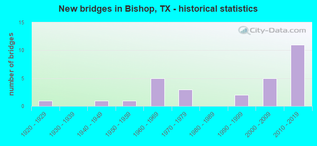
- New bridges - historical statistics
- 11920-1929
- 11940-1949
- 11950-1959
- 51960-1969
- 31970-1979
- 21990-1999
- 52000-2009
- 112010-2019

- Reconstructed bridges - Historical Statistics
- 21960-1969
- 01970-1979
- 11980-1989
- 11990-1999
- 02000-2009
- 12010-2019


- Bridge Condition - Deck
- 5.9%Very good
- 41.2%Good
- 52.9%Satisfactory

- Bridge Condition - Superstructure
- 58.8%Very good
- 29.4%Good
- 11.8%Satisfactory

- Bridge Condition - Substructure
- 11.8%Very good
- 64.7%Good
- 17.6%Satisfactory
- 5.9%Fair

- Bridge Condition - Channel
- 5.6%Very good
- 66.7%Good
- 27.8%Satisfactory

- Bridge Condition - Culverts
- 75.0%Good
- 25.0%Satisfactory
Find on map >> Show street view
Structure Number: 161780010203053, Location: 0.26 MI S OF FM 3354 (Lat: 27.618106, Lng: -97.778875), Route carried "on" structure: US 77, Year Built: 1964, Year Reconstructed: 1990, Status: Open, Structure Length: 0.79m (2.59ft), Average Daily Traffic: 22,996 (year 2019), Truck Traffic: 26%, Average Future Daily Traffic: 25,010 (year 2033), Design Load: HS 20, Features Intersected: DRAIN
Minimum Vertical Clearance: 30+ m (98+ ft), Kilometerpoint: 23.416, Lanes on structure: 5, Base Highway Network: Yes, Owner: State Highway Agency, Approaching Roadway Width: 21.6m (70.9ft), Skew: 20 degrees, Material/Design: Concrete, Design/Construction: Culvert, Number Of Spans In Main Unit: 4, Length of Maximum Span: 1.8m (5.9ft)
Condition: Channel: Good, Culverts: Satisfactory, Operating Rating: 39.9 metric tons, Method Used To Determine Operating Rating: Load Factor (LF), Inventory Rating: 23.6 metric tons, Method Used To Determine Inventory Rating: Load Factor (LF), Structural Evaluation: Somewhat better than minimum adequacy, Waterway Adequacy: Equal to present minimum criteria, Approach Roadway Alignment: Equal to present desirable criteria, Designated Inspection Frequency: Every 24 months, Inspection Date: April 2020
Find on map >> Show street view
Structure Number: 161780010203054, Location: 0.50 MI S OF FM 70 (Lat: 27.585936, Lng: -97.786025), Route carried "on" structure: US 77, Year Built: 1965, Status: Open, Structure Length: 4.63m (15.19ft), Average Daily Traffic: 9,844 (year 2017), Truck Traffic: 26%, Average Future Daily Traffic: 10,900 (year 2033), Design Load: H 20, Features Intersected: BISHOP CHANNEL
Minimum Vertical Clearance: 30+ m (98+ ft), Kilometerpoint: 27.127, Lanes on structure: 2, Owner: State Highway Agency, Approaching Roadway Width: 12.2m (40.0ft), Material/Design: Concrete, Design/Construction: Stringer/Multi-beam, Number Of Spans In Main Unit: 5, Length of Maximum Span: 9.1m (29.9ft), Curb-To-Curb Width: 12.1m (39.7ft), Out-to-Out Width: 12.8m (42.0ft)
Condition: Deck: Satisfactory, Superstructure: Good, Substructure: Good, Channel: Good, Operating Rating: 68.0 metric tons, Method Used To Determine Operating Rating: Load Factor (LF), Inventory Rating: 40.8 metric tons, Method Used To Determine Inventory Rating: Load Factor (LF), Structural Evaluation: Better than present minimum criteria, Deck Geometry: Better than present minimum criteria, Waterway Adequacy: Equal to present minimum criteria, Approach Roadway Alignment: Equal to present desirable criteria, Designated Inspection Frequency: Every 24 months, Inspection Date: May 2020, Deck Structure Type: Concrete Cast-file-Place
Find on map >> Show street view
Structure Number: 161780010203055, Location: 2.40 MI S OF FM 70 (Lat: 27.560953, Lng: -97.796722), Route carried "on" structure: US 77, Year Built: 1965, Year Reconstructed: 2015, Status: Open, Structure Length: 4.88m (16.01ft), Average Daily Traffic: 10,972 (year 2020), Truck Traffic: 21%, Average Future Daily Traffic: 15,360 (year 2033), Design Load: H 20, Features Intersected: CARRETA CREEK
Minimum Vertical Clearance: 30+ m (98+ ft), Kilometerpoint: 30.153, Lanes on structure: 3, Owner: State Highway Agency, Approaching Roadway Width: 17.1m (56.1ft), Material/Design: Concrete, Design/Construction: Stringer/Multi-beam, Number Of Spans In Main Unit: 4, Length of Maximum Span: 12.2m (40.0ft), Curb-To-Curb Width: 17.2m (56.4ft), Out-to-Out Width: 17.8m (58.4ft)
Condition: Deck: Satisfactory, Superstructure: Good, Substructure: Good, Channel: Good, Operating Rating: 54.4 metric tons, Method Used To Determine Operating Rating: Assigned ratings based on Load and Resistance Factor Design (LRFD) reported in metric tons, Inventory Rating: 32.7 metric tons, Method Used To Determine Inventory Rating: Assigned ratings based on Load and Resistance Factor Design (LRFD) reported in metric tons, Structural Evaluation: Better than present minimum criteria, Deck Geometry: Superior to present desirable criteria, Waterway Adequacy: Equal to present minimum criteria, Approach Roadway Alignment: Equal to present desirable criteria, Designated Inspection Frequency: Every 24 months, Inspection Date: May 2020, Deck Structure Type: Concrete Cast-file-Place
Find on map >> Show street view
Structure Number: 161780010203063, Location: 0.50 MI S OF FM 70 (Lat: 27.585697, Lng: -97.785247), Route carried "on" structure: US 77, Year Built: 1970, Status: Open, Structure Length: 4.63m (15.19ft), Average Daily Traffic: 9,960 (year 2017), Truck Traffic: 26%, Average Future Daily Traffic: 10,900 (year 2033), Design Load: HS 20, Features Intersected: BISHOP CHANNEL
Minimum Vertical Clearance: 30+ m (98+ ft), Kilometerpoint: 27.121, Lanes on structure: 2, Owner: State Highway Agency, Approaching Roadway Width: 12.2m (40.0ft), Material/Design: Concrete, Design/Construction: Stringer/Multi-beam, Number Of Spans In Main Unit: 5, Length of Maximum Span: 9.1m (29.9ft), Curb-To-Curb Width: 12.7m (41.7ft), Out-to-Out Width: 13.5m (44.3ft)
Condition: Deck: Satisfactory, Superstructure: Good, Substructure: Satisfactory, Channel: Good, Operating Rating: 68.0 metric tons, Method Used To Determine Operating Rating: Load Factor (LF), Inventory Rating: 40.8 metric tons, Method Used To Determine Inventory Rating: Load Factor (LF), Structural Evaluation: Equal to present minimum criteria, Deck Geometry: Better than present minimum criteria, Waterway Adequacy: Equal to present minimum criteria, Approach Roadway Alignment: Equal to present desirable criteria, Designated Inspection Frequency: Every 24 months, Inspection Date: May 2020, Deck Structure Type: Concrete Cast-file-Place
Find on map >> Show street view
Structure Number: 161780010203064, Location: 2.40 MI S OF FM 70 (Lat: 27.560481, Lng: -97.797081), Route carried "on" structure: US 77, Year Built: 1970, Status: Open, Structure Length: 4.88m (16.01ft), Average Daily Traffic: 10,065 (year 2020), Truck Traffic: 21%, Average Future Daily Traffic: 15,360 (year 2033), Design Load: HS 20, Features Intersected: CARRETA CREEK
Minimum Vertical Clearance: 30+ m (98+ ft), Kilometerpoint: 30.153, Lanes on structure: 2, Owner: State Highway Agency, Approaching Roadway Width: 12.2m (40.0ft), Material/Design: Concrete, Design/Construction: Stringer/Multi-beam, Number Of Spans In Main Unit: 4, Length of Maximum Span: 12.2m (40.0ft), Curb-To-Curb Width: 12.7m (41.7ft), Out-to-Out Width: 13.4m (44.0ft)
Condition: Deck: Satisfactory, Superstructure: Good, Substructure: Good, Channel: Satisfactory, Operating Rating: 68.0 metric tons, Method Used To Determine Operating Rating: Load Factor (LF), Inventory Rating: 40.8 metric tons, Method Used To Determine Inventory Rating: Load Factor (LF), Structural Evaluation: Better than present minimum criteria, Deck Geometry: Better than present minimum criteria, Waterway Adequacy: Equal to present minimum criteria, Approach Roadway Alignment: Equal to present desirable criteria, Designated Inspection Frequency: Every 24 months, Inspection Date: May 2020, Deck Structure Type: Concrete Cast-file-Place
Find on map >> Show street view
Structure Number: 161780010203114, Location: 0.50 MI E OF BU 77 (Lat: 27.592444, Lng: -97.783025), Route carried "on" structure: US 77, Year Built: 1995, Status: Open, Structure Length: 9.14m (29.99ft), Average Daily Traffic: 9,392 (year 2020), Truck Traffic: 26%, Average Future Daily Traffic: 12,070 (year 2033), Design Load: HS 20, Features Intersected: FM 70
Minimum Vertical Clearance: 30+ m (98+ ft), Kilometerpoint: 26.281, Lanes on structure: 2, Lanes under structure: 2, Owner: State Highway Agency, Approaching Roadway Width: 11.6m (38.1ft), Material/Design: Prestressed concrete, Design/Construction: Stringer/Multi-beam, Number Of Spans In Main Unit: 3, Length of Maximum Span: 30.5m (100.1ft), Curb-To-Curb Width: 11.3m (37.1ft), Out-to-Out Width: 12.2m (40.0ft)
Condition: Deck: Satisfactory, Superstructure: Very good, Substructure: Good, Operating Rating: 54.4 metric tons, Method Used To Determine Operating Rating: Assigned rating based on Load Factor Design (LFD) reported in metric tons, Inventory Rating: 32.7 metric tons, Method Used To Determine Inventory Rating: Assigned rating based on Load Factor Design (LFD) reported in metric tons, Structural Evaluation: Better than present minimum criteria, Deck Geometry: Equal to present minimum criteria, Underclear: Better than present minimum criteria, Approach Roadway Alignment: Equal to present desirable criteria, Designated Inspection Frequency: Every 24 months, Inspection Date: May 2020, Deck Structure Type: Concrete Precast Panels
Find on map >> Show street view
Structure Number: 161780010203115, Location: 0.50 MI E OF BU 77 (Lat: 27.592511, Lng: -97.783253), Route carried "on" structure: US 77, Year Built: 1995, Status: Open, Structure Length: 9.14m (29.99ft), Average Daily Traffic: 9,146 (year 2020), Truck Traffic: 26%, Average Future Daily Traffic: 12,070 (year 2033), Design Load: HS 20, Features Intersected: FM 70
Minimum Vertical Clearance: 30+ m (98+ ft), Kilometerpoint: 26.281, Lanes on structure: 2, Lanes under structure: 2, Owner: State Highway Agency, Approaching Roadway Width: 11.6m (38.1ft), Material/Design: Prestressed concrete, Design/Construction: Stringer/Multi-beam, Number Of Spans In Main Unit: 3, Length of Maximum Span: 30.5m (100.1ft), Curb-To-Curb Width: 11.4m (37.4ft), Out-to-Out Width: 12.2m (40.0ft)
Condition: Deck: Satisfactory, Superstructure: Very good, Substructure: Good, Operating Rating: 54.4 metric tons, Method Used To Determine Operating Rating: Assigned rating based on Load Factor Design (LFD) reported in metric tons, Inventory Rating: 32.7 metric tons, Method Used To Determine Inventory Rating: Assigned rating based on Load Factor Design (LFD) reported in metric tons, Structural Evaluation: Better than present minimum criteria, Deck Geometry: Equal to present minimum criteria, Underclear: Better than present minimum criteria, Approach Roadway Alignment: Equal to present desirable criteria, Designated Inspection Frequency: Every 24 months, Inspection Date: May 2020, Deck Structure Type: Concrete Precast Panels
Find on map >> Show street view
Structure Number: 161780010203189, Location: 0 (Lat: 27.564819, Lng: -97.792950), Route carried "on" structure: US 77, Year Built: 2018, Status: Open, Structure Length: 8.53m (27.99ft), Average Daily Traffic: 19,300 (year 2012), Truck Traffic: 26%, Average Future Daily Traffic: 24,200 (year 2032), Design Load: HL 93, Features Intersected: CR 4
Minimum Vertical Clearance: 30+ m (98+ ft), Kilometerpoint: 29.528, Lanes on structure: 2, Lanes under structure: 2, Owner: State Highway Agency, Approaching Roadway Width: 15.2m (49.9ft), Material/Design: Prestressed concrete, Design/Construction: Stringer/Multi-beam, Number Of Spans In Main Unit: 3, Length of Maximum Span: 29.0m (95.1ft), Curb-To-Curb Width: 15.1m (49.5ft), Out-to-Out Width: 15.7m (51.5ft)
Condition: Deck: Good, Superstructure: Very good, Substructure: Very good, Operating Rating: 54.4 metric tons, Method Used To Determine Operating Rating: Assigned ratings based on Load and Resistance Factor Design (LRFD) reported in metric tons, Inventory Rating: 32.7 metric tons, Method Used To Determine Inventory Rating: Assigned ratings based on Load and Resistance Factor Design (LRFD) reported in metric tons, Structural Evaluation: Equal to present desirable criteria, Deck Geometry: Superior to present desirable criteria, Underclear: Better than present minimum criteria, Approach Roadway Alignment: Equal to present desirable criteria, Designated Inspection Frequency: Every 24 months, Inspection Date: August 2020, Deck Structure Type: Concrete Precast Panels
Find on map >> Show street view
Structure Number: 16178001020319, Location: 0 (Lat: 27.564769, Lng: -97.792750), Route carried "on" structure: US 77, Year Built: 2018, Status: Open, Structure Length: 8.69m (28.51ft), Average Daily Traffic: 19,300 (year 2012), Truck Traffic: 26%, Average Future Daily Traffic: 24,200 (year 2032), Design Load: HL 93, Features Intersected: CR 4
Minimum Vertical Clearance: 30+ m (98+ ft), Kilometerpoint: 29.525, Lanes on structure: 2, Lanes under structure: 2, Owner: State Highway Agency, Approaching Roadway Width: 15.2m (49.9ft), Material/Design: Prestressed concrete, Design/Construction: Stringer/Multi-beam, Number Of Spans In Main Unit: 3, Length of Maximum Span: 29.0m (95.1ft), Curb-To-Curb Width: 15.4m (50.5ft), Out-to-Out Width: 16.0m (52.5ft)
Condition: Deck: Good, Superstructure: Very good, Substructure: Very good, Operating Rating: 54.4 metric tons, Method Used To Determine Operating Rating: Assigned ratings based on Load and Resistance Factor Design (LRFD) reported in metric tons, Inventory Rating: 32.7 metric tons, Method Used To Determine Inventory Rating: Assigned ratings based on Load and Resistance Factor Design (LRFD) reported in metric tons, Structural Evaluation: Equal to present desirable criteria, Deck Geometry: Superior to present desirable criteria, Underclear: Better than present minimum criteria, Approach Roadway Alignment: Equal to present desirable criteria, Designated Inspection Frequency: Every 24 months, Inspection Date: August 2020, Deck Structure Type: Concrete Precast Panels
Find on map >> Show street view
Structure Number: 161780010203191, Location: 0 (Lat: 27.578708, Lng: -97.787900), Route carried "on" structure: US 77, Year Built: 2018, Status: Open, Structure Length: 8.69m (28.51ft), Average Daily Traffic: 19,300 (year 2012), Truck Traffic: 26%, Average Future Daily Traffic: 27,200 (year 2032), Design Load: HL 93, Features Intersected: 6th Street
Minimum Vertical Clearance: 30+ m (98+ ft), Kilometerpoint: 27.911, Lanes on structure: 4, Lanes under structure: 3, Owner: State Highway Agency, Approaching Roadway Width: 26.8m (87.9ft), Skew: 30 degrees, Material/Design: Prestressed concrete, Design/Construction: Stringer/Multi-beam, Number Of Spans In Main Unit: 3, Length of Maximum Span: 29.0m (95.1ft), Curb-To-Curb Width: 13.4m (44.0ft), Out-to-Out Width: 28.0m (91.9ft)
Condition: Deck: Good, Superstructure: Very good, Substructure: Good, Operating Rating: 54.4 metric tons, Method Used To Determine Operating Rating: Assigned ratings based on Load and Resistance Factor Design (LRFD) reported in metric tons, Inventory Rating: 32.7 metric tons, Method Used To Determine Inventory Rating: Assigned ratings based on Load and Resistance Factor Design (LRFD) reported in metric tons, Structural Evaluation: Better than present minimum criteria, Deck Geometry: High priority of replacement, Underclear: Superior to present desirable criteria, Approach Roadway Alignment: Equal to present desirable criteria, Designated Inspection Frequency: Every 24 months, Inspection Date: August 2020, Deck Structure Type: Concrete Precast Panels
Find on map >> Show street view
Structure Number: 161780010203192, Location: 0 (Lat: 27.582050, Lng: -97.786831), Route carried "on" structure: US 77, Year Built: 2018, Status: Open, Structure Length: 8.69m (28.51ft), Average Daily Traffic: 19,300 (year 2012), Truck Traffic: 26%, Average Future Daily Traffic: 27,200 (year 2032), Design Load: HL 93, Features Intersected: FM 257/ 4th Street
Minimum Vertical Clearance: 30+ m (98+ ft), Kilometerpoint: 27.521, Lanes on structure: 4, Lanes under structure: 3, Owner: State Highway Agency, Approaching Roadway Width: 26.8m (87.9ft), Skew: 30 degrees, Material/Design: Prestressed concrete, Design/Construction: Stringer/Multi-beam, Number Of Spans In Main Unit: 3, Length of Maximum Span: 29.0m (95.1ft), Curb-To-Curb Width: 13.4m (44.0ft), Out-to-Out Width: 28.0m (91.9ft)
Condition: Deck: Good, Superstructure: Very good, Substructure: Good, Operating Rating: 54.4 metric tons, Method Used To Determine Operating Rating: Assigned ratings based on Load and Resistance Factor Design (LRFD) reported in metric tons, Inventory Rating: 32.7 metric tons, Method Used To Determine Inventory Rating: Assigned ratings based on Load and Resistance Factor Design (LRFD) reported in metric tons, Structural Evaluation: Better than present minimum criteria, Deck Geometry: High priority of replacement, Underclear: Superior to present desirable criteria, Approach Roadway Alignment: Equal to present desirable criteria, Designated Inspection Frequency: Every 24 months, Inspection Date: August 2020, Deck Structure Type: Concrete Precast Panels
Find on map >> Show street view
Structure Number: 161780010203193, Location: 0 (Lat: 27.585483, Lng: -97.785550), Route carried "on" structure: US 77, Year Built: 2018, Status: Open, Structure Length: 4.57m (14.99ft), Average Daily Traffic: 19,300 (year 2012), Truck Traffic: 26%, Average Future Daily Traffic: 27,200 (year 2032), Design Load: HL 93, Features Intersected: Bishop Creek
Minimum Vertical Clearance: 30+ m (98+ ft), Kilometerpoint: 27.127, Lanes on structure: 4, Owner: State Highway Agency, Approaching Roadway Width: 26.8m (87.9ft), Skew: 30 degrees, Material/Design: Prestressed concrete, Design/Construction: Stringer/Multi-beam, Number Of Spans In Main Unit: 1, Number Of Approach Spans: 1, Length of Maximum Span: 27.4m (89.9ft), Curb-To-Curb Width: 13.4m (44.0ft), Out-to-Out Width: 28.0m (91.9ft)
Condition: Deck: Good, Superstructure: Very good, Substructure: Good, Channel: Good, Operating Rating: 54.4 metric tons, Method Used To Determine Operating Rating: Assigned ratings based on Load and Resistance Factor Design (LRFD) reported in metric tons, Inventory Rating: 32.7 metric tons, Method Used To Determine Inventory Rating: Assigned ratings based on Load and Resistance Factor Design (LRFD) reported in metric tons, Structural Evaluation: Better than present minimum criteria, Deck Geometry: High priority of replacement, Waterway Adequacy: Superior to present desirable criteria, Approach Roadway Alignment: Equal to present desirable criteria, Designated Inspection Frequency: Every 24 months, Inspection Date: August 2020, Deck Structure Type: Concrete Precast Panels
Find on map >> Show street view
Structure Number: 161780010203194, Location: 0 (Lat: 27.607583, Lng: -97.782567), Route carried "on" structure: US 77, Year Built: 2018, Status: Open, Structure Length: 8.69m (28.51ft), Average Daily Traffic: 19,300 (year 2012), Truck Traffic: 26%, Average Future Daily Traffic: 27,200 (year 2032), Design Load: HL 93, Features Intersected: CR 10
Minimum Vertical Clearance: 30+ m (98+ ft), Kilometerpoint: 24.620, Lanes on structure: 4, Lanes under structure: 2, Owner: State Highway Agency, Approaching Roadway Width: 29.0m (95.1ft), Skew: 31 degrees, Material/Design: Prestressed concrete, Design/Construction: Stringer/Multi-beam, Number Of Spans In Main Unit: 3, Length of Maximum Span: 29.0m (95.1ft), Curb-To-Curb Width: 14.6m (47.9ft), Out-to-Out Width: 30.2m (99.1ft)
Condition: Deck: Good, Superstructure: Very good, Substructure: Good, Operating Rating: 54.4 metric tons, Method Used To Determine Operating Rating: Assigned ratings based on Load and Resistance Factor Design (LRFD) reported in metric tons, Inventory Rating: 32.7 metric tons, Method Used To Determine Inventory Rating: Assigned ratings based on Load and Resistance Factor Design (LRFD) reported in metric tons, Structural Evaluation: Better than present minimum criteria, Deck Geometry: High priority of replacement, Underclear: Better than present minimum criteria, Approach Roadway Alignment: Equal to present desirable criteria, Designated Inspection Frequency: Every 24 months, Inspection Date: August 2020, Deck Structure Type: Concrete Precast Panels
Find on map >> Show street view
Structure Number: 161780010211012, Location: 1.25 MI S OF FM 70 (Lat: 27.581683, Lng: -97.804817), Route carried "on" structure: Business State highway 77, Year Built: 1921, Year Reconstructed: 1993, Status: Posted for load, Structure Length: 4.11m (13.48ft), Average Daily Traffic: 7,520 (year 2020), Truck Traffic: 8%, Average Future Daily Traffic: 7,600 (year 2033), Features Intersected: CARRETA CREEK
Minimum Vertical Clearance: 30+ m (98+ ft), Kilometerpoint: 61.884, Lanes on structure: 4, Owner: State Highway Agency, Approaching Roadway Width: 19.5m (64.0ft), Material/Design: Concrete, Design/Construction: Tee Beam, Number Of Spans In Main Unit: 6, Length of Maximum Span: 6.7m (22.0ft), Curb or Sidewalk Widths: Left: 0.0m, Right: 1.3m (4.3ft), Curb-To-Curb Width: 19.5m (64.0ft), Out-to-Out Width: 21.8m (71.5ft)
Condition: Deck: Satisfactory, Superstructure: Satisfactory, Substructure: Satisfactory, Channel: Satisfactory, Operating Rating: 32.7 metric tons, Method Used To Determine Operating Rating: Field evaluation and documented engineering judgment, Inventory Rating: 24.5 metric tons, Method Used To Determine Inventory Rating: Field evaluation and documented engineering judgment, Structural Evaluation: Equal to present minimum criteria, Deck Geometry: Better than present minimum criteria, Waterway Adequacy: Equal to present minimum criteria, Approach Roadway Alignment: Equal to present desirable criteria, Bridge Posting: Required (Relationship of Operating Rating to Maximum Legal Load: 0.1 - 9.9% below), Designated Inspection Frequency: Every 24 months, Inspection Date: May 2020, Deck Structure Type: Concrete Cast-file-Place, Wearing Surface/Protective System: Wearing Surface: Bituminous
Find on map >> Show street view
Structure Number: 16178001021104, Location: 0.50 MI S OF FM 70 (Lat: 27.589247, Lng: -97.796100), Route carried "on" structure: Business State highway 77, Year Built: 1947, Year Reconstructed: 1968, Status: Open, Structure Length: 2.59m (8.50ft), Average Daily Traffic: 2,610 (year 2013), Truck Traffic: 8%, Average Future Daily Traffic: 3,650 (year 2033), Features Intersected: BISHOP CHANNEL
Minimum Vertical Clearance: 30+ m (98+ ft), Kilometerpoint: 60.677, Lanes on structure: 4, Owner: State Highway Agency, Approaching Roadway Width: 15.2m (49.9ft), Material/Design: Concrete, Design/Construction: Culvert, Number Of Spans In Main Unit: 11, Length of Maximum Span: 2.1m (6.9ft), Curb-To-Curb Width: 15.9m (52.2ft), Out-to-Out Width: 20.6m (67.6ft)
Condition: Channel: Good, Culverts: Satisfactory, Operating Rating: 32.7 metric tons, Method Used To Determine Operating Rating: Field evaluation and documented engineering judgment, Inventory Rating: 24.5 metric tons, Method Used To Determine Inventory Rating: Field evaluation and documented engineering judgment, Structural Evaluation: Equal to present minimum criteria, Deck Geometry: Meets minimum limits, Waterway Adequacy: Equal to present minimum criteria, Approach Roadway Alignment: Equal to present desirable criteria, Length Of Structure Improvement: 2.59m (8.50ft), Designated Inspection Frequency: Every 24 months, Inspection Date: May 2020, Deck Structure Type: Concrete Cast-file-Place, Wearing Surface/Protective System: Wearing Surface: Bituminous
Find on map >> Show street view
Structure Number: 161780155802004, Location: 0.90 MI W OF BU 77 (Lat: 27.599081, Lng: -97.804981), Route carried "on" structure: State highway 70, Year Built: 1954, Year Reconstructed: 1967, Status: Open, Structure Length: 0.98m (3.22ft), Average Daily Traffic: 789 (year 2020), Truck Traffic: 10%, Average Future Daily Traffic: 1,000 (year 2033), Features Intersected: DRAW
Minimum Vertical Clearance: 30+ m (98+ ft), Kilometerpoint: 29.039, Lanes on structure: 2, Owner: State Highway Agency, Approaching Roadway Width: 9.1m (29.9ft), Material/Design: Concrete, Design/Construction: Culvert, Number Of Spans In Main Unit: 5, Length of Maximum Span: 1.8m (5.9ft)
Condition: Channel: Good, Culverts: Good, Operating Rating: 32.7 metric tons, Method Used To Determine Operating Rating: Field evaluation and documented engineering judgment, Inventory Rating: 24.5 metric tons, Method Used To Determine Inventory Rating: Field evaluation and documented engineering judgment, Structural Evaluation: Equal to present minimum criteria, Waterway Adequacy: Equal to present minimum criteria, Approach Roadway Alignment: Equal to present desirable criteria, Length Of Structure Improvement: 1.01m (3.31ft), Designated Inspection Frequency: Every 24 months, Inspection Date: May 2020, Bridge Improvement Cost: $48,000, Roadway Improvement Cost: $5,000, Total Project Cost: $72,000
Find on map >> Show street view
Structure Number: 161780345701001, Location: 1.90 MI E OF US 77 (Lat: 27.613294, Lng: -97.746625), Route carried "on" structure: State highway 3354, Year Built: 1978, Status: Open, Structure Length: 0.82m (2.69ft), Average Daily Traffic: 318 (year 2020), Truck Traffic: 13%, Average Future Daily Traffic: 490 (year 2033), Design Load: HS 20, Features Intersected: DRAIN
Minimum Vertical Clearance: 30+ m (98+ ft), Kilometerpoint: 4.738, Lanes on structure: 2, Owner: State Highway Agency, Approaching Roadway Width: 6.1m (20.0ft), Skew: 3 degrees, Material/Design: Concrete, Design/Construction: Culvert, Number Of Spans In Main Unit: 3, Length of Maximum Span: 2.1m (6.9ft), Curb-To-Curb Width: 8.5m (27.9ft), Out-to-Out Width: 9.1m (29.9ft)
Condition: Channel: Good, Culverts: Good, Operating Rating: 39.9 metric tons, Method Used To Determine Operating Rating: Load Factor (LF), Inventory Rating: 23.6 metric tons, Method Used To Determine Inventory Rating: Load Factor (LF), Structural Evaluation: Equal to present minimum criteria, Deck Geometry: Equal to present minimum criteria, Waterway Adequacy: Better than present minimum criteria, Approach Roadway Alignment: Equal to present desirable criteria, Designated Inspection Frequency: Every 48 months, Inspection Date: June 2018, Deck Structure Type: Concrete Cast-file-Place, Wearing Surface/Protective System: Wearing Surface: Bituminous
Find on map >> Show street view
Structure Number: 161780AA0163002, Location: 0.40 MI S OF FM 3354 (Lat: 27.606181, Lng: -97.748517), Route carried "on" structure: County highway 77, Year Built: 2011, Status: Open, Structure Length: 0.91m (2.99ft), Average Daily Traffic: 10 (year 2015), Average Future Daily Traffic: 10 (year 2035), Features Intersected: DRAINAGE DITCH
Minimum Vertical Clearance: 30+ m (98+ ft), Kilometerpoint: 2.012, Lanes on structure: 2, Owner: County Highway Agency, Approaching Roadway Width: 3.7m (12.1ft), Material/Design: Concrete, Design/Construction: Culvert, Number Of Spans In Main Unit: 3, Length of Maximum Span: 3.0m (9.8ft), Curb-To-Curb Width: 8.5m (27.9ft), Out-to-Out Width: 9.2m (30.2ft)
Condition: Channel: Good, Culverts: Good, Operating Rating: 32.7 metric tons, Method Used To Determine Operating Rating: Field evaluation and documented engineering judgment, Inventory Rating: 24.5 metric tons, Method Used To Determine Inventory Rating: Field evaluation and documented engineering judgment, Structural Evaluation: Equal to present minimum criteria, Deck Geometry: Better than present minimum criteria, Waterway Adequacy: Equal to present minimum criteria, Approach Roadway Alignment: Equal to present desirable criteria, Designated Inspection Frequency: Every 24 months, Inspection Date: May 2021, Deck Structure Type: Concrete Cast-file-Place, Wearing Surface/Protective System: Wearing Surface: Gravel
Find on map >> Show street view
Structure Number: 161780AA0175001, Location: 0.70 MI S OF FM 70 (Lat: 27.593214, Lng: -97.821336), Route carried "on" structure: County highway 85, Year Built: 2004, Status: Open, Structure Length: 0.67m (2.20ft), Average Daily Traffic: 273 (year 2016), Average Future Daily Traffic: 400 (year 2035), Design Load: HS 20, Features Intersected: DRAINAGE DITCH
Minimum Vertical Clearance: 30+ m (98+ ft), Kilometerpoint: 1.127, Lanes on structure: 2, Owner: County Highway Agency, Approaching Roadway Width: 6.7m (22.0ft), Material/Design: Concrete, Design/Construction: Culvert, Number Of Spans In Main Unit: 4, Length of Maximum Span: 1.5m (4.9ft), Curb-To-Curb Width: 7.5m (24.6ft), Out-to-Out Width: 9.2m (30.2ft)
Condition: Channel: Very good, Culverts: Good, Operating Rating: 54.4 metric tons, Method Used To Determine Operating Rating: No rating analysis performed, Inventory Rating: 32.7 metric tons, Method Used To Determine Inventory Rating: No rating analysis performed, Structural Evaluation: Better than present minimum criteria, Deck Geometry: Somewhat better than minimum adequacy, Waterway Adequacy: Meets minimum limits, Approach Roadway Alignment: Equal to present desirable criteria, Designated Inspection Frequency: Every 24 months, Inspection Date: April 2021, Deck Structure Type: Concrete Cast-file-Place, Wearing Surface/Protective System: Wearing Surface: Bituminous
Find on map >> Show street view
Structure Number: 161780AA0175002, Location: 1.00 MI S OF FM 70 (Lat: 27.588083, Lng: -97.823158), Route carried "on" structure: County highway 85, Year Built: 2005, Status: Posted for load, Structure Length: 2.29m (7.51ft), Average Daily Traffic: 273 (year 2016), Average Future Daily Traffic: 400 (year 2035), Features Intersected: CARRETA CREEK
Minimum Vertical Clearance: 30+ m (98+ ft), Kilometerpoint: 1.609, Lanes on structure: 2, Owner: County Highway Agency, Approaching Roadway Width: 6.7m (22.0ft), Skew: 3 degrees, Material/Design: Prestressed concrete, Number Of Spans In Main Unit: 1, Number Of Approach Spans: 1, Length of Maximum Span: 13.7m (44.9ft), Curb-To-Curb Width: 7.3m (24.0ft), Out-to-Out Width: 8.0m (26.2ft)
Condition: Deck: Good, Superstructure: Very good, Substructure: Good, Channel: Good, Operating Rating: 32.7 metric tons, Method Used To Determine Operating Rating: Field evaluation and documented engineering judgment, Inventory Rating: 24.5 metric tons, Method Used To Determine Inventory Rating: Field evaluation and documented engineering judgment, Structural Evaluation: Equal to present minimum criteria, Deck Geometry: Somewhat better than minimum adequacy, Waterway Adequacy: Better than present minimum criteria, Approach Roadway Alignment: Equal to present desirable criteria, Bridge Posting: Required (Relationship of Operating Rating to Maximum Legal Load: 0.1 - 9.9% below), Length Of Structure Improvement: 2.59m (8.50ft), Designated Inspection Frequency: Every 24 months, Inspection Date: April 2021, Bridge Improvement Cost: $7,000, Roadway Improvement Cost: $2,000, Total Project Cost: $9,000, Deck Structure Type: Concrete Cast-file-Place
Find on map >> Show street view
Structure Number: 161780AA0189001, Location: 0.15 MI W OF US 77 (Lat: 27.566092, Lng: -97.796036), Route carried "on" structure: County highway 4, Year Built: 2004, Status: Open, Structure Length: 2.44m (8.01ft), Average Daily Traffic: 100 (year 2016), Average Future Daily Traffic: 400 (year 2035), Design Load: HL 93, Features Intersected: CARRETA CREEK
Minimum Vertical Clearance: 30+ m (98+ ft), Kilometerpoint: 0.241, Lanes on structure: 2, Owner: County Highway Agency, Approaching Roadway Width: 6.1m (20.0ft), Material/Design: Prestressed concrete, Design/Construction: Stringer/Multi-beam, Number Of Spans In Main Unit: 1, Length of Maximum Span: 24.4m (80.1ft), Curb-To-Curb Width: 7.1m (23.3ft), Out-to-Out Width: 7.9m (25.9ft)
Condition: Deck: Very good, Superstructure: Very good, Substructure: Good, Channel: Good, Operating Rating: 54.4 metric tons, Method Used To Determine Operating Rating: Assigned ratings based on Load and Resistance Factor Design (LRFD) reported in metric tons, Inventory Rating: 32.7 metric tons, Method Used To Determine Inventory Rating: Assigned ratings based on Load and Resistance Factor Design (LRFD) reported in metric tons, Structural Evaluation: Better than present minimum criteria, Deck Geometry: Somewhat better than minimum adequacy, Waterway Adequacy: Superior to present desirable criteria, Approach Roadway Alignment: Equal to present desirable criteria, Designated Inspection Frequency: Every 24 months, Inspection Date: May 2021, Deck Structure Type: Concrete Precast Panels
Find on map >> Show street view
Structure Number: 161780AA0190001, Location: 0.3 MI E OF US 77 (Lat: 27.577733, Lng: -97.783175), Route carried "on" structure: County highway 6, Year Built: 1960, Status: Posted for load, Structure Length: 3.81m (12.50ft), Average Daily Traffic: 640 (year 2015), Average Future Daily Traffic: 800 (year 2035), Features Intersected: DRAINAGE DITCH
Minimum Vertical Clearance: 30+ m (98+ ft), Kilometerpoint: 0.483, Lanes on structure: 2, Owner: County Highway Agency, Approaching Roadway Width: 5.5m (18.0ft), Skew: 3 degrees, Material/Design: Concrete, Design/Construction: Slab, Number Of Spans In Main Unit: 5, Length of Maximum Span: 7.6m (24.9ft), Curb-To-Curb Width: 7.2m (23.6ft), Out-to-Out Width: 7.8m (25.6ft)
Condition: Deck: Satisfactory, Superstructure: Satisfactory, Substructure: Satisfactory, Channel: Good, Operating Rating: 32.7 metric tons, Method Used To Determine Operating Rating: Field evaluation and documented engineering judgment, Inventory Rating: 24.5 metric tons, Method Used To Determine Inventory Rating: Field evaluation and documented engineering judgment, Structural Evaluation: Equal to present minimum criteria, Deck Geometry: Meets minimum limits, Waterway Adequacy: Better than present minimum criteria, Approach Roadway Alignment: Equal to present desirable criteria, Bridge Posting: Required (Relationship of Operating Rating to Maximum Legal Load: 0.1 - 9.9% below), Designated Inspection Frequency: Every 24 months, Inspection Date: May 2021, Deck Structure Type: Concrete Cast-file-Place
Find on map >> Show street view
Structure Number: 161780AA0190002, Location: 0.01 MI W OF CR 85 (Lat: 27.588803, Lng: -97.823028), Route carried "on" structure: County highway 6, Year Built: 2005, Status: Open, Structure Length: 0.98m (3.22ft), Average Daily Traffic: 273 (year 2016), Average Future Daily Traffic: 100 (year 2035), Design Load: HS 20, Features Intersected: DRAINAGE DITCH
Minimum Vertical Clearance: 30+ m (98+ ft), Kilometerpoint: 14.323, Lanes on structure: 2, Owner: County Highway Agency, Approaching Roadway Width: 7.9m (25.9ft), Material/Design: Concrete, Design/Construction: Culvert, Number Of Spans In Main Unit: 3, Length of Maximum Span: 2.7m (8.9ft), Curb-To-Curb Width: 8.5m (27.9ft), Out-to-Out Width: 12.1m (39.7ft)
Condition: Channel: Satisfactory, Culverts: Good, Operating Rating: 54.4 metric tons, Method Used To Determine Operating Rating: Assigned rating based on Load Factor Design (LFD) reported in metric tons, Inventory Rating: 32.7 metric tons, Method Used To Determine Inventory Rating: Assigned rating based on Load Factor Design (LFD) reported in metric tons, Structural Evaluation: Better than present minimum criteria, Deck Geometry: Equal to present minimum criteria, Waterway Adequacy: Better than present minimum criteria, Approach Roadway Alignment: Equal to present desirable criteria, Length Of Structure Improvement: 0.88m (2.89ft), Designated Inspection Frequency: Every 24 months, Inspection Date: May 2021, Bridge Improvement Cost: $24,000, Roadway Improvement Cost: $6,000, Total Project Cost: $30,000, Deck Structure Type: Concrete Cast-file-Place, Wearing Surface/Protective System: Wearing Surface: Bituminous
Find on map >> Show street view
Structure Number: 161780AA0191001, Location: 1.0 MI N OF FM 70 (Lat: 27.595125, Lng: -97.735283), Route carried "on" structure: County highway 75, Year Built: 2005, Status: Open, Structure Length: 1.04m (3.41ft), Average Daily Traffic: 70 (year 2015), Average Future Daily Traffic: 100 (year 2035), Design Load: HL 93, Features Intersected: DRAINAGE DITCH
Minimum Vertical Clearance: 30+ m (98+ ft), Kilometerpoint: 3.380, Lanes on structure: 2, Owner: County Highway Agency, Approaching Roadway Width: 4.9m (16.1ft), Skew: 1 degrees, Material/Design: Concrete, Design/Construction: Culvert, Number Of Spans In Main Unit: 3, Length of Maximum Span: 3.0m (9.8ft), Curb-To-Curb Width: 11.6m (38.1ft), Out-to-Out Width: 12.2m (40.0ft)
Condition: Channel: Satisfactory, Culverts: Good, Operating Rating: 54.4 metric tons, Method Used To Determine Operating Rating: Assigned ratings based on Load and Resistance Factor Design (LRFD) reported in metric tons, Inventory Rating: 32.7 metric tons, Method Used To Determine Inventory Rating: Assigned ratings based on Load and Resistance Factor Design (LRFD) reported in metric tons, Structural Evaluation: Better than present minimum criteria, Deck Geometry: Superior to present desirable criteria, Waterway Adequacy: Meets minimum limits, Approach Roadway Alignment: Equal to present desirable criteria, Length Of Structure Improvement: 0.94m (3.08ft), Designated Inspection Frequency: Every 24 months, Inspection Date: May 2021, Bridge Improvement Cost: $11,000, Roadway Improvement Cost: $3,000, Total Project Cost: $14,000, Deck Structure Type: Concrete Cast-file-Place, Wearing Surface/Protective System: Wearing Surface: Gravel
Find on map >> Show street view
Structure Number: 161780D00200001, Location: 0.25 MI N OF 4TH ST (Lat: 27.586986, Lng: -97.789408), Route carried "on" structure: City street , Year Built: 1960, Status: Posted for load, Structure Length: 4.63m (15.19ft), Average Daily Traffic: 100 (year 2015), Average Future Daily Traffic: 200 (year 2035), Features Intersected: DRAINAGE DITCH, Facility Carried by Structure: N. HACKBERRY AVE.
Minimum Vertical Clearance: 30+ m (98+ ft), Kilometerpoint: 0.402, Lanes on structure: 2, Owner: City or Municipal Highway Agency, Approaching Roadway Width: 6.1m (20.0ft), Material/Design: Concrete, Design/Construction: Stringer/Multi-beam, Number Of Spans In Main Unit: 5, Length of Maximum Span: 9.1m (29.9ft), Curb or Sidewalk Widths: Left: 0.0m, Right: 0.9m (3.0ft), Curb-To-Curb Width: 6.6m (21.7ft), Out-to-Out Width: 8.1m (26.6ft)
Condition: Deck: Satisfactory, Superstructure: Good, Substructure: Fair, Channel: Satisfactory, Operating Rating: 32.7 metric tons, Method Used To Determine Operating Rating: Field evaluation and documented engineering judgment, Inventory Rating: 24.5 metric tons, Method Used To Determine Inventory Rating: Field evaluation and documented engineering judgment, Structural Evaluation: Somewhat better than minimum adequacy, Deck Geometry: Somewhat better than minimum adequacy, Waterway Adequacy: Better than present minimum criteria, Approach Roadway Alignment: Equal to present desirable criteria, Bridge Posting: Required (Relationship of Operating Rating to Maximum Legal Load: 0.1 - 9.9% below), Designated Inspection Frequency: Every 24 months, Inspection Date: May 2021, Deck Structure Type: Concrete Cast-file-Place
Find on map >> Show street view
Structure Number: 16178001020319, Location: 0 (Lat: 27.564769, Lng: -97.792750), Route carried "under" structure: County highway 4, Year Built: 2018, Structure Length: 0. m, Features Intersected: CR 4, Facility Carried by Structure: US 77 NB ML
Minimum Vertical Clearance: 4.90m (16.08ft), Lanes on structure: 2, Lanes under structure: 2, Material/Design: Prestressed concrete, Design/Construction: Stringer/Multi-beam, Length of Maximum Span: 29.0m (95.1ft)
Find on map >> Show street view
Structure Number: 161780010203191, Location: 0 (Lat: 27.578708, Lng: -97.787900), Year Built: 2018, Structure Length: 0. m, Features Intersected: 6th Street
Minimum Vertical Clearance: 5.51m (18.08ft), Lanes on structure: 4, Lanes under structure: 3, Material/Design: Prestressed concrete, Design/Construction: Stringer/Multi-beam, Length of Maximum Span: 29.0m (95.1ft)
Find on map >> Show street view
Structure Number: 161780010203192, Location: 0 (Lat: 27.582050, Lng: -97.786831), Route carried "under" structure: State highway 257, Year Built: 2018, Structure Length: 0. m, Average Daily Traffic: 2,344 (year 2016), Features Intersected: FM 257 / 4th Street, Facility Carried by Structure: US 77
Minimum Vertical Clearance: 5.19m (17.03ft), Kilometerpoint: 1.308, Lanes on structure: 4, Lanes under structure: 3, Material/Design: Prestressed concrete, Design/Construction: Stringer/Multi-beam, Length of Maximum Span: 29.0m (95.1ft)
Find on map >> Show street view
Structure Number: 161780010203194, Location: 0 (Lat: 27.607583, Lng: -97.782567), Route carried "under" structure: County highway 10, Year Built: 2018, Structure Length: 0. m, Features Intersected: CR 10, Facility Carried by Structure: US 77
Minimum Vertical Clearance: 4.90m (16.08ft), Lanes on structure: 4, Lanes under structure: 2, Material/Design: Prestressed concrete, Design/Construction: Stringer/Multi-beam, Length of Maximum Span: 29.0m (95.1ft)