Bridge Statistics for Bishop, California (CA)
Condition, Traffic, Stress, Structural Evaluation, Project Costs
- National Bridge Inventory (NBI) Statistics
- 13Number of bridges
- 62ft / 19.3mTotal length
- 131,326Total average daily traffic
- 13,797Total average daily truck traffic
- 156,558Total future (year 2038) average daily traffic
- National Bridge Inventory (NBI) Registered Bridges for Bishop
- No street view available for this location
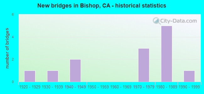
- New bridges - historical statistics
- 11920-1929
- 11930-1939
- 21940-1949
- 31970-1979
- 51980-1989
- 11990-1999

- Reconstructed bridges - Historical Statistics
- 11940-1949
- 01950-1959
- 21960-1969
- 01970-1979
- 11980-1989


- Bridge Condition - Deck
- 88.9%Good
- 11.1%Fair

- Bridge Condition - Superstructure
- 88.9%Good
- 11.1%Fair

- Bridge Condition - Substructure
- 33.3%Good
- 66.7%Fair

- Bridge Condition - Channel
- 7.7%Excellent
- 84.6%Very good
- 7.7%Good
Find on map >> Show street view
Structure Number: 48 001, Location: 09-INY-395-31.28 (Lat: 36.236369, Lng: -117.983981), Route carried "on" structure: US 395, Year Built: 1928, Year Reconstructed: 1953, Status: Open, Structure Length: 1.46m (4.79ft), Average Daily Traffic: 12,600 (year 2019), Truck Traffic: 12%, Average Future Daily Traffic: 14,925 (year 2038), Design Load: HS 20, Features Intersected: LOS ANGELES AQUEDUCT
Minimum Vertical Clearance: 30+ m (98+ ft), Kilometerpoint: 31.280, Lanes on structure: 2, Base Highway Network: Yes (Inventory Route: 3, Subroute: 1), Owner: State Highway Agency, Approaching Roadway Width: 9.8m (32.2ft), Skew: 3 degrees, Material/Design: Steel, Design/Construction: Stringer/Multi-beam, Number Of Spans In Main Unit: 1, Length of Maximum Span: 13.7m (44.9ft), Curb-To-Curb Width: 12.2m (40.0ft), Out-to-Out Width: 13.0m (42.7ft)
Condition: Deck: Good, Superstructure: Good, Substructure: Good, Channel: Excellent, Operating Rating: 48.9 metric tons, Method Used To Determine Operating Rating: Load Factor (LF), Inventory Rating: 29.2 metric tons, Method Used To Determine Inventory Rating: Load Factor (LF), Structural Evaluation: Better than present minimum criteria, Deck Geometry: Somewhat better than minimum adequacy, Waterway Adequacy: Superior to present desirable criteria, Approach Roadway Alignment: Equal to present desirable criteria, Designated Inspection Frequency: Every 24 months, Inspection Date: May 2020, Deck Structure Type: Concrete Cast-file-Place, Wearing Surface/Protective System: Wearing Surface: Bituminous, Membrane: Preformed Fabric
Find on map >> Show street view
Structure Number: 48 0016, Location: 09-INY-395-117.61-BIS (Lat: 37.375911, Lng: -118.418461), Route carried "on" structure: US 395, Year Built: 1971, Status: Open, Structure Length: 1.22m (4.00ft), Average Daily Traffic: 21,550 (year 2017), Truck Traffic: 10%, Average Future Daily Traffic: 25,912 (year 2038), Design Load: HS 20, Features Intersected: NORTH FORK BISHOP CREEK
Minimum Vertical Clearance: 30+ m (98+ ft), Kilometerpoint: 117.610, Lanes on structure: 5, Base Highway Network: Yes (Inventory Route: 3, Subroute: 1), Owner: State Highway Agency, Approaching Roadway Width: 21.0m (68.9ft), Skew: 3 degrees, Material/Design: Prestressed concrete, Design/Construction: Slab, Number Of Spans In Main Unit: 1, Length of Maximum Span: 11.6m (38.1ft), Curb or Sidewalk Widths: Left: 1.2m (3.9ft), Right: 1.2m (3.9ft), Curb-To-Curb Width: 21.0m (68.9ft), Out-to-Out Width: 24.4m (80.1ft)
Condition: Deck: Fair, Superstructure: Fair, Substructure: Fair, Channel: Very good, Operating Rating: 54.4 metric tons, Method Used To Determine Operating Rating: Load Factor (LF), Inventory Rating: 32.4 metric tons, Method Used To Determine Inventory Rating: Load Factor (LF), Structural Evaluation: Somewhat better than minimum adequacy, Deck Geometry: Somewhat better than minimum adequacy, Waterway Adequacy: Equal to present desirable criteria, Approach Roadway Alignment: Equal to present desirable criteria, Designated Inspection Frequency: Every 24 months, Inspection Date: September 2020, Deck Structure Type: Concrete Cast-file-Place, Wearing Surface/Protective System: Wearing Surface: Bituminous, Membrane: Preformed Fabric
Find on map >> Show street view
Structure Number: 48 0023, Location: 09-INY-006-0.45-BIS (Lat: 37.380483, Lng: -118.395319), Route carried "on" structure: US 6, Year Built: 1937, Year Reconstructed: 1973, Status: Open, Structure Length: 1.28m (4.20ft), Average Daily Traffic: 4,550 (year 2017), Truck Traffic: 20%, Average Future Daily Traffic: 5,390 (year 2038), Design Load: H 15, Features Intersected: BISHOP CREEK
Minimum Vertical Clearance: 30+ m (98+ ft), Kilometerpoint: 0.450, Lanes on structure: 2, Base Highway Network: Yes (, Subroute: 1), Owner: State Highway Agency, Approaching Roadway Width: 9.1m (29.9ft), Material/Design: Concrete continuous, Design/Construction: Slab, Number Of Spans In Main Unit: 2, Length of Maximum Span: 6.1m (20.0ft), Curb-To-Curb Width: 12.4m (40.7ft), Out-to-Out Width: 13.2m (43.3ft)
Condition: Deck: Good, Superstructure: Good, Substructure: Good, Channel: Very good, Operating Rating: 38.9 metric tons, Method Used To Determine Operating Rating: Load Factor (LF), Inventory Rating: 23.3 metric tons, Method Used To Determine Inventory Rating: Load Factor (LF), Structural Evaluation: Equal to present minimum criteria, Deck Geometry: Equal to present minimum criteria, Waterway Adequacy: Equal to present desirable criteria, Approach Roadway Alignment: Equal to present desirable criteria, Designated Inspection Frequency: Every 24 months, Inspection Date: September 2020, Deck Structure Type: Concrete Cast-file-Place, Wearing Surface/Protective System: Wearing Surface: Bituminous, Membrane: Preformed Fabric
Find on map >> Show street view
Structure Number: 48 0024, Location: 09-INY-006-3.73-BIS (Lat: 37.398581, Lng: -118.356133), Route carried "on" structure: US 6, Year Built: 1949, Year Reconstructed: 1973, Status: Open, Structure Length: 3.34m (10.96ft), Average Daily Traffic: 4,550 (year 2017), Truck Traffic: 20%, Average Future Daily Traffic: 5,390 (year 2038), Design Load: HS 20, Features Intersected: OWENS RIVER
Minimum Vertical Clearance: 30+ m (98+ ft), Kilometerpoint: 3.730, Lanes on structure: 2, Base Highway Network: Yes (, Subroute: 1), Owner: State Highway Agency, Approaching Roadway Width: 9.1m (29.9ft), Material/Design: Steel, Design/Construction: Stringer/Multi-beam, Number Of Spans In Main Unit: 3, Length of Maximum Span: 10.8m (35.4ft), Curb-To-Curb Width: 12.4m (40.7ft), Out-to-Out Width: 13.2m (43.3ft)
Condition: Deck: Good, Superstructure: Good, Substructure: Fair, Channel: Very good, Operating Rating: 52.2 metric tons, Method Used To Determine Operating Rating: Load Factor (LF), Inventory Rating: 31.4 metric tons, Method Used To Determine Inventory Rating: Load Factor (LF), Structural Evaluation: Somewhat better than minimum adequacy, Deck Geometry: Equal to present minimum criteria, Waterway Adequacy: Equal to present desirable criteria, Approach Roadway Alignment: Equal to present desirable criteria, Designated Inspection Frequency: Every 24 months, Inspection Date: September 2020, Deck Structure Type: Concrete Cast-file-Place, Wearing Surface/Protective System: Wearing Surface: Bituminous, Membrane: Preformed Fabric
Find on map >> Show street view
Structure Number: 48 0025, Location: 09-INY-168-15.40-BIS (Lat: 37.361197, Lng: -118.448419), Route carried "on" structure: State highway 168, Year Built: 1982, Status: Open, Structure Length: 0.79m (2.59ft), Average Daily Traffic: 8,000 (year 2017), Truck Traffic: 4%, Average Future Daily Traffic: 9,476 (year 2040), Design Load: HS 20, Features Intersected: NORTH FORK BISHOP CREEK
Minimum Vertical Clearance: 30+ m (98+ ft), Kilometerpoint: 15.400, Lanes on structure: 2, Owner: State Highway Agency, Approaching Roadway Width: 12.5m (41.0ft), Skew: 1 degrees, Material/Design: Concrete, Design/Construction: Slab, Number Of Spans In Main Unit: 1, Length of Maximum Span: 5.5m (18.0ft), Curb-To-Curb Width: 12.2m (40.0ft), Out-to-Out Width: 13.2m (43.3ft)
Condition: Deck: Good, Superstructure: Good, Substructure: Fair, Channel: Very good, Operating Rating: 50.2 metric tons, Method Used To Determine Operating Rating: Load Factor (LF), Inventory Rating: 30.1 metric tons, Method Used To Determine Inventory Rating: Load Factor (LF), Structural Evaluation: Somewhat better than minimum adequacy, Deck Geometry: Somewhat better than minimum adequacy, Waterway Adequacy: Equal to present desirable criteria, Approach Roadway Alignment: Equal to present desirable criteria, Designated Inspection Frequency: Every 24 months, Inspection Date: September 2020, Deck Structure Type: Concrete Cast-file-Place, Wearing Surface/Protective System: Wearing Surface: Bituminous, Membrane: Preformed Fabric
Find on map >> Show street view
Structure Number: 48 0028, Location: 09-INY-168-15.79-BIS (Lat: 37.361264, Lng: -118.441511), Route carried "on" structure: State highway 168, Year Built: 1982, Status: Open, Structure Length: 0.64m (2.10ft), Average Daily Traffic: 8,000 (year 2017), Truck Traffic: 4%, Average Future Daily Traffic: 9,470 (year 2038), Design Load: HS 20, Features Intersected: SOUTH FORK BISHOP CREEK
Minimum Vertical Clearance: 30+ m (98+ ft), Kilometerpoint: 15.790, Lanes on structure: 2, Owner: State Highway Agency, Approaching Roadway Width: 12.5m (41.0ft), Material/Design: Concrete, Design/Construction: Slab, Number Of Spans In Main Unit: 1, Length of Maximum Span: 6.1m (20.0ft), Curb-To-Curb Width: 12.2m (40.0ft), Out-to-Out Width: 13.2m (43.3ft)
Condition: Deck: Good, Superstructure: Good, Substructure: Fair, Channel: Very good, Operating Rating: 61.6 metric tons, Method Used To Determine Operating Rating: Load Factor (LF), Inventory Rating: 36.9 metric tons, Method Used To Determine Inventory Rating: Load Factor (LF), Structural Evaluation: Somewhat better than minimum adequacy, Deck Geometry: Somewhat better than minimum adequacy, Waterway Adequacy: Equal to present desirable criteria, Approach Roadway Alignment: Equal to present desirable criteria, Designated Inspection Frequency: Every 24 months, Inspection Date: September 2020, Deck Structure Type: Concrete Cast-file-Place, Wearing Surface/Protective System: Wearing Surface: Bituminous
Find on map >> Show street view
Structure Number: 48 0036, Location: 09-INY-395-100.20 (Lat: 37.164528, Lng: -118.289400), Route carried "on" structure: US 395, Year Built: 1993, Status: Open, Structure Length: 0.94m (3.08ft), Average Daily Traffic: 13,500 (year 2019), Truck Traffic: 14%, Average Future Daily Traffic: 15,991 (year 2038), Features Intersected: BIG PINE CREEK
Minimum Vertical Clearance: 30+ m (98+ ft), Kilometerpoint: 100.200, Lanes on structure: 5, Base Highway Network: Yes (Inventory Route: 3, Subroute: 1), Owner: State Highway Agency, Approaching Roadway Width: 20.0m (65.6ft), Skew: 6 degrees, Material/Design: Concrete, Design/Construction: Culvert, Number Of Spans In Main Unit: 2, Length of Maximum Span: 4.0m (13.1ft)
Condition: Channel: Very good, Culverts: Good, Operating Rating: 54.1 metric tons, Method Used To Determine Operating Rating: Field evaluation and documented engineering judgment, Inventory Rating: 32.4 metric tons, Method Used To Determine Inventory Rating: Field evaluation and documented engineering judgment, Structural Evaluation: Better than present minimum criteria, Waterway Adequacy: Equal to present desirable criteria, Approach Roadway Alignment: Superior to present desirable criteria, Designated Inspection Frequency: Every 24 months, Inspection Date: May 2020
Find on map >> Show street view
Structure Number: 48 0038, Location: 09-INY-006-6.46-BIS (Lat: 37.435375, Lng: -118.349581), Route carried "on" structure: US 6, Year Built: 1949, Year Reconstructed: 1987, Status: Open, Structure Length: 0.70m (2.30ft), Average Daily Traffic: 4,550 (year 2017), Truck Traffic: 20%, Average Future Daily Traffic: 5,390 (year 2038), Design Load: HS 20, Features Intersected: LOWER MCNALLY CANAL
Minimum Vertical Clearance: 30+ m (98+ ft), Kilometerpoint: 6.460, Lanes on structure: 2, Base Highway Network: Yes (, Subroute: 1), Owner: State Highway Agency, Approaching Roadway Width: 10.0m (32.8ft), Material/Design: Concrete, Design/Construction: Slab, Number Of Spans In Main Unit: 1, Length of Maximum Span: 6.1m (20.0ft), Curb-To-Curb Width: 12.4m (40.7ft), Out-to-Out Width: 13.2m (43.3ft)
Condition: Deck: Good, Superstructure: Good, Substructure: Fair, Channel: Very good, Operating Rating: 44.1 metric tons, Method Used To Determine Operating Rating: Load Factor (LF), Inventory Rating: 26.2 metric tons, Method Used To Determine Inventory Rating: Load Factor (LF), Structural Evaluation: Somewhat better than minimum adequacy, Deck Geometry: Equal to present minimum criteria, Waterway Adequacy: Equal to present desirable criteria, Approach Roadway Alignment: Equal to present desirable criteria, Designated Inspection Frequency: Every 24 months, Inspection Date: September 2020, Deck Structure Type: Concrete Cast-file-Place, Wearing Surface/Protective System: Wearing Surface: Bituminous, Membrane: Preformed Fabric
Find on map >> Show street view
Structure Number: 48 0061, Location: 09-INY-168-R19.79 (Lat: 37.178314, Lng: -118.265194), Route carried "on" structure: State highway 168, Year Built: 1974, Status: Open, Structure Length: 3.14m (10.30ft), Average Daily Traffic: 8,820 (year 2017), Truck Traffic: 10%, Average Future Daily Traffic: 10,448 (year 2038), Design Load: HS 20, Features Intersected: OWENS RIVER
Minimum Vertical Clearance: 30+ m (98+ ft), Kilometerpoint: 19.790, Lanes on structure: 2, Base Highway Network: Yes (Inventory Route: 1, Subroute: 1), Owner: State Highway Agency, Approaching Roadway Width: 12.2m (40.0ft), Material/Design: Prestressed concrete, Design/Construction: Stringer/Multi-beam, Number Of Spans In Main Unit: 1, Length of Maximum Span: 30.5m (100.1ft), Curb-To-Curb Width: 12.2m (40.0ft), Out-to-Out Width: 13.2m (43.3ft)
Condition: Deck: Good, Superstructure: Good, Substructure: Fair, Channel: Very good, Operating Rating: 58.3 metric tons, Method Used To Determine Operating Rating: Load and Resistance Factor Rating (LRFR) rating reported by rating factor(RF) method using HL-93 loadings, Inventory Rating: 29.2 metric tons, Method Used To Determine Inventory Rating: Load and Resistance Factor Rating (LRFR) rating reported by rating factor(RF) method using HL-93 loadings, Structural Evaluation: Somewhat better than minimum adequacy, Deck Geometry: Somewhat better than minimum adequacy, Waterway Adequacy: Equal to present desirable criteria, Approach Roadway Alignment: Equal to present desirable criteria, Designated Inspection Frequency: Every 24 months, Inspection Date: September 2020, Deck Structure Type: Concrete Cast-file-Place, Wearing Surface/Protective System: Wearing Surface: Bituminous, Membrane: Preformed Fabric
Find on map >> Show street view
Structure Number: 48 0063, Location: 09-INY-395-R127.73-BIS (Lat: 37.439775, Lng: -118.570467), Route carried "on" structure: US 395, Year Built: 1975, Status: Open, Structure Length: 0.79m (2.59ft), Average Daily Traffic: 15,000 (year 2017), Truck Traffic: 10%, Average Future Daily Traffic: 18,037 (year 2038), Features Intersected: LOWER ROCK CREEK
Minimum Vertical Clearance: 30+ m (98+ ft), Kilometerpoint: 127.730, Lanes on structure: 4, Base Highway Network: Yes (Inventory Route: 3, Subroute: 1), Owner: State Highway Agency, Approaching Roadway Width: 33.2m (108.9ft), Skew: 23 degrees, Material/Design: Concrete continuous, Design/Construction: Culvert, Number Of Spans In Main Unit: 3, Length of Maximum Span: 2.4m (7.9ft)
Condition: Channel: Very good, Culverts: Good, Operating Rating: 54.1 metric tons, Method Used To Determine Operating Rating: Field evaluation and documented engineering judgment, Inventory Rating: 32.4 metric tons, Method Used To Determine Inventory Rating: Field evaluation and documented engineering judgment, Structural Evaluation: Better than present minimum criteria, Waterway Adequacy: Equal to present desirable criteria, Approach Roadway Alignment: Equal to present desirable criteria, Designated Inspection Frequency: Every 48 months, Inspection Date: August 2018
Find on map >> Show street view
Structure Number: 48 0065, Location: 09-INY-395-119.60-BIS (Lat: 37.375894, Lng: -118.455869), Route carried "on" structure: US 395, Year Built: 1985, Status: Open, Structure Length: 0.88m (2.89ft), Average Daily Traffic: 21,550 (year 2017), Truck Traffic: 10%, Average Future Daily Traffic: 25,912 (year 2038), Features Intersected: BISHOP CRK OVERFLOW CHNL
Minimum Vertical Clearance: 30+ m (98+ ft), Kilometerpoint: 119.600, Lanes on structure: 5, Base Highway Network: Yes (Inventory Route: 3, Subroute: 1), Owner: State Highway Agency, Approaching Roadway Width: 34.0m (111.5ft), Material/Design: Concrete continuous, Design/Construction: Culvert, Number Of Spans In Main Unit: 2, Length of Maximum Span: 4.3m (14.1ft), Curb-To-Curb Width: 34.0m (111.5ft), Out-to-Out Width: 34.6m (113.5ft)
Condition: Channel: Very good, Culverts: Good, Operating Rating: 54.1 metric tons, Method Used To Determine Operating Rating: Field evaluation and documented engineering judgment, Inventory Rating: 32.4 metric tons, Method Used To Determine Inventory Rating: Field evaluation and documented engineering judgment, Structural Evaluation: Better than present minimum criteria, Deck Geometry: Superior to present desirable criteria, Waterway Adequacy: Superior to present desirable criteria, Approach Roadway Alignment: Equal to present desirable criteria, Designated Inspection Frequency: Every 48 months, Inspection Date: August 2018, Deck Structure Type: Concrete Cast-file-Place, Wearing Surface/Protective System: Wearing Surface: Bituminous
Find on map >> Show street view
Structure Number: 48 0066, Location: 09-INY-168-14.90-BIS (Lat: 37.360114, Lng: -118.456356), Route carried "on" structure: State highway 168, Year Built: 1985, Status: Open, Structure Length: 1.04m (3.41ft), Average Daily Traffic: 8,000 (year 2017), Truck Traffic: 4%, Average Future Daily Traffic: 9,477 (year 2040), Features Intersected: BISHOP CREEK OVERFLOW
Minimum Vertical Clearance: 30+ m (98+ ft), Kilometerpoint: 14.900, Lanes on structure: 2, Owner: State Highway Agency, Approaching Roadway Width: 8.2m (26.9ft), Skew: 3 degrees, Material/Design: Concrete continuous, Design/Construction: Culvert, Number Of Spans In Main Unit: 2, Length of Maximum Span: 5.2m (17.1ft), Curb-To-Curb Width: 25.3m (83.0ft), Out-to-Out Width: 25.9m (85.0ft)
Condition: Channel: Good, Culverts: Good, Operating Rating: 54.1 metric tons, Method Used To Determine Operating Rating: Field evaluation and documented engineering judgment, Inventory Rating: 32.4 metric tons, Method Used To Determine Inventory Rating: Field evaluation and documented engineering judgment, Structural Evaluation: Better than present minimum criteria, Deck Geometry: Superior to present desirable criteria, Waterway Adequacy: Superior to present desirable criteria, Approach Roadway Alignment: Equal to present desirable criteria, Designated Inspection Frequency: Every 48 months, Inspection Date: August 2018
Find on map >> Show street view
Structure Number: 48C0003, Location: 3.1 MI E OF ROUTE 395 (Lat: 37.362150, Lng: -118.339189), Route carried "on" structure: County highway , Year Built: 1987, Status: Open, Structure Length: 3.05m (10.01ft), Average Daily Traffic: 656 (year 2017), Truck Traffic: 2%, Average Future Daily Traffic: 740 (year 2038), Design Load: HS 20+Mod, Features Intersected: OWENS RIVER, Facility Carried by Structure: POLETA RD
Minimum Vertical Clearance: 30+ m (98+ ft), Kilometerpoint: 0.000, Lanes on structure: 2, Owner: County Highway Agency, Approaching Roadway Width: 7.3m (24.0ft), Material/Design: Concrete continuous, Design/Construction: Stringer/Multi-beam, Number Of Spans In Main Unit: 2, Length of Maximum Span: 14.9m (48.9ft), Curb-To-Curb Width: 9.8m (32.2ft), Out-to-Out Width: 10.0m (32.8ft)
Condition: Deck: Good, Superstructure: Good, Substructure: Good, Channel: Very good, Operating Rating: 54.1 metric tons, Method Used To Determine Operating Rating: Assigned rating based on Load Factor Design (LFD) reported in metric tons, Inventory Rating: 32.4 metric tons, Method Used To Determine Inventory Rating: Assigned rating based on Load Factor Design (LFD) reported in metric tons, Structural Evaluation: Better than present minimum criteria, Deck Geometry: Equal to present minimum criteria, Waterway Adequacy: Equal to present desirable criteria, Approach Roadway Alignment: Equal to present desirable criteria, Designated Inspection Frequency: Every 24 months, Underwater Inspection Frequency: Every 60 months, Inspection Date: August 2021, Underwater Inspection Date: October 2018, Deck Structure Type: Concrete Cast-file-Place, Wearing Surface/Protective System: Deck Protection: Epoxy Coated Reinforcing