Bridge Statistics for Berlin, Vermont (VT)
Condition, Traffic, Stress, Structural Evaluation, Project Costs
- National Bridge Inventory (NBI) Statistics
- 32Number of bridges
- 348ft / 106mTotal length
- $7,109,000Total costs
- 266,533Total average daily traffic
- 25,453Total average daily truck traffic
- National Bridge Inventory (NBI) Registered Bridges for Berlin
- No street view available for this location
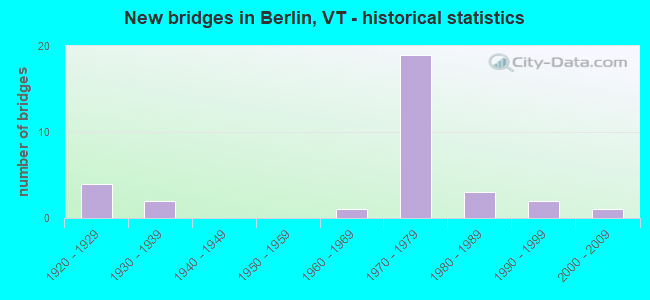
- New bridges - historical statistics
- 41920-1929
- 21930-1939
- 11960-1969
- 191970-1979
- 31980-1989
- 21990-1999
- 12000-2009

- Reconstructed bridges - Historical Statistics
- 11930-1939
- 01940-1949
- 11950-1959
- 01960-1969
- 01970-1979
- 21980-1989
- 11990-1999
- 22000-2009


- Bridge Condition - Deck
- 34.8%Very good
- 30.4%Good
- 17.4%Satisfactory
- 13.0%Fair
- 4.3%Poor

- Bridge Condition - Superstructure
- 21.7%Very good
- 47.8%Good
- 26.1%Satisfactory
- 4.3%Fair

- Bridge Condition - Substructure
- 8.7%Very good
- 52.2%Good
- 39.1%Satisfactory

- Bridge Condition - Channel
- 69.2%Very good
- 15.4%Good
- 15.4%Satisfactory
Find on map >> Show street view
Structure Number: 101203000412031, Location: 0.4 MI TO JCT W CL2 TH7 (Lat: 44.268331, Lng: -72.637103), Route carried "on" structure: Other road C2002, Year Built: 1929, Status: Open, Structure Length: 1.65m (5.41ft), Average Daily Traffic: 710 (year 2019), Truck Traffic: 3%, Average Future Daily Traffic: 746 (year 2029), Design Load: H 15, Features Intersected: JONES BROOK
Minimum Vertical Clearance: 30+ m (98+ ft), Kilometerpoint: 0.000, Lanes on structure: 2, Owner: Town or Township Highway Agency, Approaching Roadway Width: 6.7m (22.0ft), Material/Design: Concrete, Design/Construction: Tee Beam, Number Of Spans In Main Unit: 1, Length of Maximum Span: 15.5m (50.9ft), Curb or Sidewalk Widths: Left: 0.1m (0.3ft), Right: 0.1m (0.3ft), Curb-To-Curb Width: 6.4m (21.0ft), Out-to-Out Width: 7.2m (23.6ft)
Condition: Deck: Satisfactory, Superstructure: Good, Substructure: Good, Channel: Satisfactory, Operating Rating: 33.6 metric tons, Method Used To Determine Operating Rating: Load Factor (LF), Inventory Rating: 20.0 metric tons, Method Used To Determine Inventory Rating: Load Factor (LF), Structural Evaluation: Somewhat better than minimum adequacy, Deck Geometry: High priority of corrective action, Waterway Adequacy: Better than present minimum criteria, Approach Roadway Alignment: Equal to present desirable criteria, Length Of Structure Improvement: 1.65m (5.41ft), Designated Inspection Frequency: Every 24 months, Inspection Date: July 2020, Bridge Improvement Cost: $444,000, Roadway Improvement Cost: $50,000, Total Project Cost: $494,000 ( Estimate for 2020), Deck Structure Type: Concrete Cast-file-Place, Wearing Surface/Protective System: Wearing Surface: Gravel
Find on map >> Show street view
Structure Number: 101203000512031, Location: @ MONT-BERLIN T/L (Lat: 44.256019, Lng: -72.601222), Route carried "on" structure: Other road C2002, Year Built: 2002, Status: Open, Structure Length: 2.74m (8.99ft), Average Daily Traffic: 1,110 (year 2019), Truck Traffic: 10%, Average Future Daily Traffic: 1,166 (year 2029), Design Load: HS 25 or greater, Features Intersected: DOG RIVER
Minimum Vertical Clearance: 30+ m (98+ ft), Kilometerpoint: 0.000, Lanes on structure: 2, Owner: Town or Township Highway Agency, Approaching Roadway Width: 8.8m (28.9ft), Material/Design: Steel, Design/Construction: Stringer/Multi-beam, Number Of Spans In Main Unit: 1, Length of Maximum Span: 26.8m (87.9ft), Curb or Sidewalk Widths: Left: 0.1m (0.3ft), Right: 0.1m (0.3ft), Curb-To-Curb Width: 9.1m (29.9ft), Out-to-Out Width: 9.6m (31.5ft)
Condition: Deck: Very good, Superstructure: Very good, Substructure: Good, Channel: Very good, Operating Rating: 89.8 metric tons, Method Used To Determine Operating Rating: Load Factor (LF), Inventory Rating: 67.1 metric tons, Method Used To Determine Inventory Rating: Load Factor (LF), Structural Evaluation: Better than present minimum criteria, Deck Geometry: Somewhat better than minimum adequacy, Waterway Adequacy: Better than present minimum criteria, Approach Roadway Alignment: Equal to present desirable criteria, Designated Inspection Frequency: Every 24 months, Inspection Date: July 2020, Deck Structure Type: Concrete Cast-file-Place, Wearing Surface/Protective System: Wearing Surface: Bituminous, Membrane: Preformed Fabric, Deck Protection: Epoxy Coated Reinforcing
Find on map >> Show street view
Structure Number: 101203002412031, Location: 0.02 MI TO JCT W CL2 TH3 (Lat: 44.186714, Lng: -72.673300), Route carried "on" structure: Other road C3060, Year Built: 1990, Status: Open, Structure Length: 1.74m (5.71ft), Average Daily Traffic: 50 (year 2019), Truck Traffic: 2%, Average Future Daily Traffic: 53 (year 2029), Design Load: H 15, Features Intersected: COX BROOK
Minimum Vertical Clearance: 30+ m (98+ ft), Kilometerpoint: 0.000, Lanes on structure: 1, Owner: Town or Township Highway Agency, Approaching Roadway Width: 4.6m (15.1ft), Material/Design: Steel, Design/Construction: Stringer/Multi-beam, Number Of Spans In Main Unit: 1, Length of Maximum Span: 16.8m (55.1ft), Curb-To-Curb Width: 5.9m (19.4ft), Out-to-Out Width: 6.3m (20.7ft)
Condition: Deck: Good, Superstructure: Fair, Substructure: Good, Channel: Very good, Operating Rating: 21.8 metric tons, Method Used To Determine Operating Rating: Allowable Stress (AS), Inventory Rating: 13.6 metric tons, Method Used To Determine Inventory Rating: Allowable Stress (AS), Structural Evaluation: Meets minimum limits, Deck Geometry: Meets minimum limits, Waterway Adequacy: Equal to present minimum criteria, Approach Roadway Alignment: Equal to present desirable criteria, Length Of Structure Improvement: 1.74m (5.71ft), Designated Inspection Frequency: Every 24 months, Inspection Date: July 2020, Bridge Improvement Cost: $415,000, Roadway Improvement Cost: $50,000, Total Project Cost: $465,000 ( Estimate for 2020), Deck Structure Type: Wood or Timber, Wearing Surface/Protective System: Wearing Surface: Wood or Timber, Membrane: Preformed Fabric, Deck Protection: Internally Sealed
Find on map >> Show street view
Structure Number: 101203002512031, Location: 0.02 MI TO JCT W CL2 TH8 (Lat: 44.250389, Lng: -72.600789), Route carried "on" structure: Other road C3051, Year Built: 1977, Status: Open, Structure Length: 3.14m (10.30ft), Average Daily Traffic: 10 (year 2019), Truck Traffic: 2%, Average Future Daily Traffic: 11 (year 2029), Design Load: HS 20, Features Intersected: DOG RIVER
Minimum Vertical Clearance: 30+ m (98+ ft), Kilometerpoint: 0.000, Lanes on structure: 1, Owner: Private, Approaching Roadway Width: 4.9m (16.1ft), Material/Design: Steel, Design/Construction: Stringer/Multi-beam, Number Of Spans In Main Unit: 1, Length of Maximum Span: 30.5m (100.1ft), Curb or Sidewalk Widths: Left: 0.2m (0.7ft), Right: 0.2m (0.7ft), Curb-To-Curb Width: 4.3m (14.1ft), Out-to-Out Width: 4.9m (16.1ft)
Condition: Deck: Very good, Superstructure: Very good, Substructure: Good, Channel: Very good, Operating Rating: 89.8 metric tons, Method Used To Determine Operating Rating: Load Factor (LF), Inventory Rating: 60.8 metric tons, Method Used To Determine Inventory Rating: Load Factor (LF), Structural Evaluation: Better than present minimum criteria, Deck Geometry: Equal to present minimum criteria, Waterway Adequacy: Equal to present minimum criteria, Approach Roadway Alignment: Equal to present desirable criteria, Length Of Structure Improvement: 3.14m (10.30ft), Designated Inspection Frequency: Every 24 months, Inspection Date: July 2020, Bridge Improvement Cost: $580,000, Roadway Improvement Cost: $50,000, Total Project Cost: $630,000 ( Estimate for 2020), Deck Structure Type: Concrete Cast-file-Place
Find on map >> Show street view
Structure Number: 101203002612031, Location: 0.08 MI TO JCT W US302 (Lat: 44.232611, Lng: -72.551453), Route carried "on" structure: Other road C3027, Year Built: 1987, Status: Open, Structure Length: 1.92m (6.30ft), Average Daily Traffic: 400 (year 2019), Truck Traffic: 2%, Average Future Daily Traffic: 420 (year 2029), Design Load: HS 20, Features Intersected: STEVENS BRANCH
Minimum Vertical Clearance: 30+ m (98+ ft), Kilometerpoint: 0.000, Lanes on structure: 2, Owner: Town or Township Highway Agency, Approaching Roadway Width: 9.8m (32.2ft), Skew: 1 degrees, Material/Design: Steel, Design/Construction: Stringer/Multi-beam, Number Of Spans In Main Unit: 1, Length of Maximum Span: 18.6m (61.0ft), Curb or Sidewalk Widths: Left: 0.2m (0.7ft), Right: 0.2m (0.7ft), Curb-To-Curb Width: 8.2m (26.9ft), Out-to-Out Width: 9.1m (29.9ft)
Condition: Deck: Very good, Superstructure: Good, Substructure: Good, Channel: Good, Operating Rating: 70.8 metric tons, Method Used To Determine Operating Rating: Allowable Stress (AS), Inventory Rating: 35.4 metric tons, Method Used To Determine Inventory Rating: Allowable Stress (AS), Structural Evaluation: Better than present minimum criteria, Deck Geometry: Somewhat better than minimum adequacy, Waterway Adequacy: Better than present minimum criteria, Approach Roadway Alignment: Equal to present minimum criteria, Designated Inspection Frequency: Every 24 months, Inspection Date: July 2020, Deck Structure Type: Concrete Cast-file-Place, Wearing Surface/Protective System: Wearing Surface: Bituminous, Membrane: Preformed Fabric, Deck Protection: Epoxy Coated Reinforcing
Find on map >> Show street view
Structure Number: 101203002712031, Location: 0.1 MI TO JCT W VT12 (Lat: 44.187639, Lng: -72.640792), Route carried "on" structure: Other road C3061, Year Built: 1928, Year Reconstructed: 1994, Status: Closed, Structure Length: 2.71m (8.89ft), Average Daily Traffic: 277 (year 2019), Truck Traffic: 2%, Average Future Daily Traffic: 291 (year 2029), Design Load: HS 20, Features Intersected: DOG RIVER
Minimum Vertical Clearance: 30+ m (98+ ft), Kilometerpoint: 0.000, Lanes on structure: 1, Owner: Town or Township Highway Agency, Approaching Roadway Width: 6.7m (22.0ft), Material/Design: Steel, Design/Construction: Truss - Thru, Number Of Spans In Main Unit: 1, Length of Maximum Span: 25.9m (85.0ft), Curb or Sidewalk Widths: Left: 0.1m (0.3ft), Right: 0.1m (0.3ft), Curb-To-Curb Width: 4.6m (15.1ft), Out-to-Out Width: 4.9m (16.1ft)
Condition: Deck: Fair, Superstructure: Satisfactory, Substructure: Satisfactory, Channel: Very good, Approach Roadway Alignment: Meets minimum limits, Length Of Structure Improvement: 3.54m (11.61ft), Designated Inspection Frequency: Every 24 months, Critical Feature Inspection Frequency: Every 24 months, Other Special Inspection Frequency: Every 24 months, Inspection Date: July 2018, Critical Feature Inspection Date: July 2018, Other Special Inspection Date: June 2019, Bridge Improvement Cost: $628,000, Roadway Improvement Cost: $150,000, Total Project Cost: $778,000 ( Estimate for 2020), Deck Structure Type: Wood or Timber, Wearing Surface/Protective System: Wearing Surface: Bituminous, Deck Protection: Internally Sealed
Find on map >> Show street view
Structure Number: 101203002812031, Location: 0.04 MI TO JCT W VT12 (Lat: 44.221314, Lng: -72.622714), Route carried "on" structure: Other road C3039, Year Built: 1984, Status: Open, Structure Length: 4.11m (13.48ft), Average Daily Traffic: 100 (year 2019), Truck Traffic: 2%, Average Future Daily Traffic: 105 (year 2029), Design Load: HS 20, Features Intersected: DOG RIVER
Minimum Vertical Clearance: 30+ m (98+ ft), Kilometerpoint: 0.000, Lanes on structure: 2, Owner: Town or Township Highway Agency, Approaching Roadway Width: 7.9m (25.9ft), Material/Design: Steel continuous, Design/Construction: Stringer/Multi-beam, Number Of Spans In Main Unit: 3, Length of Maximum Span: 29.0m (95.1ft), Curb or Sidewalk Widths: Left: 0.2m (0.7ft), Right: 0.2m (0.7ft), Curb-To-Curb Width: 7.0m (23.0ft), Out-to-Out Width: 7.8m (25.6ft)
Condition: Deck: Very good, Superstructure: Very good, Substructure: Very good, Channel: Very good, Operating Rating: 77.1 metric tons, Method Used To Determine Operating Rating: Allowable Stress (AS), Inventory Rating: 48.1 metric tons, Method Used To Determine Inventory Rating: Allowable Stress (AS), Structural Evaluation: Equal to present desirable criteria, Deck Geometry: Somewhat better than minimum adequacy, Waterway Adequacy: Better than present minimum criteria, Approach Roadway Alignment: Equal to present desirable criteria, Designated Inspection Frequency: Every 24 months, Inspection Date: July 2020, Deck Structure Type: Concrete Cast-file-Place
Find on map >> Show street view
Structure Number: 101203002912031, Location: 0.01 MI TO JCT W CL2 TH2 (Lat: 44.265656, Lng: -72.628967), Route carried "on" structure: Other road C2007, Year Built: 1928, Year Reconstructed: 1991, Status: Open, Structure Length: 5.61m (18.41ft), Average Daily Traffic: 666 (year 2019), Truck Traffic: 2%, Average Future Daily Traffic: 700 (year 2029), Features Intersected: WINOOSKI RIVER
Minimum Vertical Clearance: 4.62m (15.16ft), Kilometerpoint: 0.000, Lanes on structure: 1, Owner: Town or Township Highway Agency, Approaching Roadway Width: 6.4m (21.0ft), Material/Design: Steel, Design/Construction: Truss - Thru, Number Of Spans In Main Unit: 1, Length of Maximum Span: 54.6m (179.1ft), Curb or Sidewalk Widths: Left: 0.2m (0.7ft), Right: 0.2m (0.7ft), Curb-To-Curb Width: 4.8m (15.7ft), Out-to-Out Width: 5.1m (16.7ft)
Condition: Deck: Good, Superstructure: Satisfactory, Substructure: Satisfactory, Channel: Very good, Operating Rating: 36.3 metric tons, Method Used To Determine Operating Rating: Allowable Stress (AS), Inventory Rating: 20.0 metric tons, Method Used To Determine Inventory Rating: Allowable Stress (AS), Structural Evaluation: Somewhat better than minimum adequacy, Deck Geometry: High priority of corrective action, Waterway Adequacy: Better than present minimum criteria, Approach Roadway Alignment: Meets minimum limits, Length Of Structure Improvement: 5.61m (18.41ft), Designated Inspection Frequency: Every 24 months, Critical Feature Inspection Frequency: Every 24 months, Inspection Date: July 2020, Critical Feature Inspection Date: July 2020, Bridge Improvement Cost: $1,075,000, Roadway Improvement Cost: $50,000, Total Project Cost: $1,126,000 ( Estimate for 2020), Deck Structure Type: Concrete Cast-file-Place, Wearing Surface/Protective System: Deck Protection: Epoxy Coated Reinforcing
Find on map >> Show street view
Structure Number: 101203003012031, Location: 0.1 MI TO JCT W VT12 (Lat: 44.228978, Lng: -72.600881), Route carried "on" structure: Other road C3016, Year Built: 1967, Year Reconstructed: 1999, Status: Open, Structure Length: 1.92m (6.30ft), Average Daily Traffic: 30 (year 2019), Truck Traffic: 2%, Average Future Daily Traffic: 32 (year 2029), Design Load: HS 25 or greater, Features Intersected: DOG RIVER
Minimum Vertical Clearance: 30+ m (98+ ft), Kilometerpoint: 0.000, Lanes on structure: 1, Owner: Town or Township Highway Agency, Approaching Roadway Width: 4.6m (15.1ft), Material/Design: Prestressed concrete, Design/Construction: Box Beam or Girders - Multiple, Number Of Spans In Main Unit: 1, Length of Maximum Span: 18.3m (60.0ft), Curb-To-Curb Width: 4.5m (14.8ft), Out-to-Out Width: 4.8m (15.7ft)
Condition: Deck: Very good, Superstructure: Very good, Substructure: Good, Channel: Very good, Operating Rating: 68.0 metric tons, Method Used To Determine Operating Rating: Field evaluation and documented engineering judgment, Inventory Rating: 40.8 metric tons, Method Used To Determine Inventory Rating: Field evaluation and documented engineering judgment, Structural Evaluation: Better than present minimum criteria, Deck Geometry: Equal to present minimum criteria, Waterway Adequacy: Better than present minimum criteria, Approach Roadway Alignment: Equal to present minimum criteria, Designated Inspection Frequency: Every 24 months, Inspection Date: July 2020, Deck Structure Type: Concrete Precast Panels, Wearing Surface/Protective System: Wearing Surface: Bituminous, Membrane: Preformed Fabric
Find on map >> Show street view
Structure Number: 200089036N12032, Location: I 89 EXIT 6 (Lat: 44.167778, Lng: -72.577233), Route carried "on" structure: Interstate 89, Year Built: 1970, Status: Open, Structure Length: 5.30m (17.39ft), Average Daily Traffic: 20,900 (year 2018), Truck Traffic: 13%, Average Future Daily Traffic: 21,945 (year 2028), Design Load: HS 20, Features Intersected: I 89 OVER VT 63
Minimum Vertical Clearance: 30+ m (98+ ft), Kilometerpoint: 75.494, Lanes on structure: 2, Lanes under structure: 2, Base Highway Network: Yes, Owner: State Highway Agency, Approaching Roadway Width: 12.2m (40.0ft), Skew: 12 degrees, Material/Design: Steel continuous, Design/Construction: Stringer/Multi-beam, Number Of Spans In Main Unit: 2, Length of Maximum Span: 26.2m (86.0ft), Curb or Sidewalk Widths: Left: 0.2m (0.7ft), Right: 0.2m (0.7ft), Curb-To-Curb Width: 12.1m (39.7ft), Out-to-Out Width: 13.3m (43.6ft)
Condition: Deck: Fair, Superstructure: Satisfactory, Substructure: Satisfactory, Operating Rating: 78.9 metric tons, Method Used To Determine Operating Rating: Load Factor (LF), Inventory Rating: 47.2 metric tons, Method Used To Determine Inventory Rating: Load Factor (LF), Structural Evaluation: Equal to present minimum criteria, Deck Geometry: Equal to present minimum criteria, Underclear: Better than present minimum criteria, Approach Roadway Alignment: Equal to present desirable criteria, Designated Inspection Frequency: Every 24 months, Inspection Date: May 2020, Deck Structure Type: Concrete Cast-file-Place, Wearing Surface/Protective System: Wearing Surface: Bituminous
Find on map >> Show street view
Structure Number: 200089036S12032, Location: I 89 EXIT 6 (Lat: 44.167806, Lng: -72.577925), Route carried "on" structure: Interstate 89, Year Built: 1970, Status: Open, Structure Length: 5.30m (17.39ft), Average Daily Traffic: 20,900 (year 2018), Truck Traffic: 13%, Average Future Daily Traffic: 21,945 (year 2028), Design Load: HS 20, Features Intersected: I 89 OVER VT 63
Minimum Vertical Clearance: 30+ m (98+ ft), Kilometerpoint: 75.494, Lanes on structure: 2, Lanes under structure: 2, Base Highway Network: Yes, Owner: State Highway Agency, Approaching Roadway Width: 12.5m (41.0ft), Skew: 12 degrees, Material/Design: Steel continuous, Design/Construction: Stringer/Multi-beam, Number Of Spans In Main Unit: 2, Length of Maximum Span: 26.2m (86.0ft), Curb or Sidewalk Widths: Left: 0.2m (0.7ft), Right: 0.2m (0.7ft), Curb-To-Curb Width: 12.1m (39.7ft), Out-to-Out Width: 13.3m (43.6ft)
Condition: Deck: Satisfactory, Superstructure: Good, Substructure: Satisfactory, Operating Rating: 78.9 metric tons, Method Used To Determine Operating Rating: Load Factor (LF), Inventory Rating: 47.2 metric tons, Method Used To Determine Inventory Rating: Load Factor (LF), Structural Evaluation: Equal to present minimum criteria, Deck Geometry: Equal to present minimum criteria, Underclear: Somewhat better than minimum adequacy, Approach Roadway Alignment: Equal to present desirable criteria, Designated Inspection Frequency: Every 24 months, Inspection Date: May 2020, Deck Structure Type: Concrete Cast-file-Place, Wearing Surface/Protective System: Wearing Surface: Bituminous, Membrane: Preformed Fabric
Find on map >> Show street view
Structure Number: 200089037N12032, Location: 0.2 MI S EXIT 7 (Lat: 44.211508, Lng: -72.582528), Route carried "on" structure: Interstate 89, Year Built: 1970, Status: Open, Structure Length: 3.75m (12.30ft), Average Daily Traffic: 20,900 (year 2018), Truck Traffic: 8%, Average Future Daily Traffic: 21,945 (year 2028), Design Load: HS 20, Features Intersected: I 89 OVER TH NO 40
Minimum Vertical Clearance: 30+ m (98+ ft), Kilometerpoint: 80.450, Lanes on structure: 3, Lanes under structure: 2, Base Highway Network: Yes, Owner: State Highway Agency, Approaching Roadway Width: 13.7m (44.9ft), Skew: 14 degrees, Material/Design: Steel, Design/Construction: Stringer/Multi-beam, Number Of Spans In Main Unit: 1, Length of Maximum Span: 35.4m (116.1ft), Curb-To-Curb Width: 14.2m (46.6ft), Out-to-Out Width: 17.2m (56.4ft)
Condition: Deck: Very good, Superstructure: Good, Substructure: Good, Operating Rating: 89.8 metric tons, Method Used To Determine Operating Rating: Load Factor (LF), Inventory Rating: 61.7 metric tons, Method Used To Determine Inventory Rating: Load Factor (LF), Structural Evaluation: Better than present minimum criteria, Deck Geometry: Meets minimum limits, Underclear: High priority of corrective action, Approach Roadway Alignment: Equal to present desirable criteria, Designated Inspection Frequency: Every 24 months, Inspection Date: December 2020, Deck Structure Type: Concrete Cast-file-Place, Wearing Surface/Protective System: Wearing Surface: Bituminous, Membrane: Preformed Fabric, Deck Protection: Epoxy Coated Reinforcing
Find on map >> Show street view
Structure Number: 200089037S12032, Location: 0.2 MI S EXIT 7 (Lat: 44.211586, Lng: -72.582858), Route carried "on" structure: Interstate 89, Year Built: 1970, Status: Open, Structure Length: 3.72m (12.20ft), Average Daily Traffic: 20,900 (year 2018), Truck Traffic: 8%, Average Future Daily Traffic: 21,945 (year 2028), Design Load: HS 20, Features Intersected: I 89 OVER TH NO 40
Minimum Vertical Clearance: 30+ m (98+ ft), Kilometerpoint: 80.450, Lanes on structure: 2, Lanes under structure: 2, Base Highway Network: Yes, Owner: State Highway Agency, Approaching Roadway Width: 12.2m (40.0ft), Skew: 13 degrees, Material/Design: Steel, Design/Construction: Stringer/Multi-beam, Number Of Spans In Main Unit: 1, Length of Maximum Span: 34.7m (113.8ft), Curb or Sidewalk Widths: Left: 0.2m (0.7ft), Right: 0.2m (0.7ft), Curb-To-Curb Width: 11.6m (38.1ft), Out-to-Out Width: 12.9m (42.3ft)
Condition: Deck: Satisfactory, Superstructure: Good, Substructure: Good, Operating Rating: 89.8 metric tons, Method Used To Determine Operating Rating: Load Factor (LF), Inventory Rating: 60.8 metric tons, Method Used To Determine Inventory Rating: Load Factor (LF), Structural Evaluation: Better than present minimum criteria, Deck Geometry: Equal to present minimum criteria, Underclear: Somewhat better than minimum adequacy, Approach Roadway Alignment: Equal to present desirable criteria, Designated Inspection Frequency: Every 24 months, Inspection Date: December 2020, Deck Structure Type: Concrete Cast-file-Place, Wearing Surface/Protective System: Wearing Surface: Bituminous
Find on map >> Show street view
Structure Number: 200089038N12032, Location: I 89 EXIT 7 (Lat: 44.215647, Lng: -72.583592), Route carried "on" structure: Interstate 89, Year Built: 1970, Status: Open, Structure Length: 5.30m (17.39ft), Average Daily Traffic: 20,900 (year 2018), Truck Traffic: 8%, Average Future Daily Traffic: 21,945 (year 2028), Design Load: HS 20, Features Intersected: I 89 OVER VT 62
Minimum Vertical Clearance: 30+ m (98+ ft), Kilometerpoint: 80.917, Lanes on structure: 2, Lanes under structure: 2, Base Highway Network: Yes, Owner: State Highway Agency, Approaching Roadway Width: 12.5m (41.0ft), Skew: 12 degrees, Material/Design: Steel continuous, Design/Construction: Stringer/Multi-beam, Number Of Spans In Main Unit: 2, Length of Maximum Span: 26.2m (86.0ft), Curb-To-Curb Width: 12.2m (40.0ft), Out-to-Out Width: 13.4m (44.0ft)
Condition: Deck: Very good, Superstructure: Good, Substructure: Satisfactory, Operating Rating: 89.8 metric tons, Method Used To Determine Operating Rating: Load Factor (LF), Inventory Rating: 56.2 metric tons, Method Used To Determine Inventory Rating: Load Factor (LF), Structural Evaluation: Equal to present minimum criteria, Deck Geometry: Better than present minimum criteria, Underclear: Superior to present desirable criteria, Approach Roadway Alignment: Equal to present desirable criteria, Designated Inspection Frequency: Every 24 months, Inspection Date: December 2020, Deck Structure Type: Concrete Cast-file-Place, Wearing Surface/Protective System: Wearing Surface: Bituminous, Membrane: Preformed Fabric, Deck Protection: Epoxy Coated Reinforcing
Find on map >> Show street view
Structure Number: 200089038S12032, Location: I 89 EXIT 7 (Lat: 44.215706, Lng: -72.583892), Route carried "on" structure: Interstate 89, Year Built: 1970, Status: Open, Structure Length: 5.30m (17.39ft), Average Daily Traffic: 20,900 (year 2018), Truck Traffic: 8%, Average Future Daily Traffic: 21,945 (year 2028), Design Load: HS 20, Features Intersected: I 89 OVER VT 62
Minimum Vertical Clearance: 30+ m (98+ ft), Kilometerpoint: 80.917, Lanes on structure: 3, Lanes under structure: 2, Base Highway Network: Yes, Owner: State Highway Agency, Approaching Roadway Width: 14.3m (46.9ft), Skew: 12 degrees, Material/Design: Steel continuous, Design/Construction: Stringer/Multi-beam, Number Of Spans In Main Unit: 2, Length of Maximum Span: 26.2m (86.0ft), Curb or Sidewalk Widths: Left: 0.2m (0.7ft), Right: 0.2m (0.7ft), Curb-To-Curb Width: 14.3m (46.9ft), Out-to-Out Width: 15.1m (49.5ft)
Condition: Deck: Fair, Superstructure: Good, Substructure: Good, Operating Rating: 78.9 metric tons, Method Used To Determine Operating Rating: Load Factor (LF), Inventory Rating: 47.2 metric tons, Method Used To Determine Inventory Rating: Load Factor (LF), Structural Evaluation: Better than present minimum criteria, Deck Geometry: Meets minimum limits, Underclear: Meets minimum limits, Approach Roadway Alignment: Equal to present desirable criteria, Designated Inspection Frequency: Every 24 months, Inspection Date: December 2020, Deck Structure Type: Concrete Cast-file-Place, Wearing Surface/Protective System: Wearing Surface: Bituminous
Find on map >> Show street view
Structure Number: 200089040N12032, Location: 0.5 MI S EXIT 8 (Lat: 44.247250, Lng: -72.588808), Route carried "on" structure: Interstate 89, Year Built: 1970, Year Reconstructed: 2008, Status: Open, Structure Length: 13.38m (43.90ft), Average Daily Traffic: 23,900 (year 2018), Truck Traffic: 13%, Average Future Daily Traffic: 25,095 (year 2028), Design Load: HS 25 or greater, Features Intersected: I 89 OVER VT 12
Minimum Vertical Clearance: 30+ m (98+ ft), Kilometerpoint: 84.521, Lanes on structure: 2, Lanes under structure: 2, Base Highway Network: Yes, Owner: State Highway Agency, Approaching Roadway Width: 12.2m (40.0ft), Skew: 14 degrees, Material/Design: Steel, Design/Construction: Stringer/Multi-beam, Number Of Spans In Main Unit: 3, Length of Maximum Span: 44.5m (146.0ft), Curb-To-Curb Width: 11.9m (39.0ft), Out-to-Out Width: 12.8m (42.0ft)
Condition: Deck: Good, Superstructure: Good, Substructure: Satisfactory, Operating Rating: 89.8 metric tons, Method Used To Determine Operating Rating: Load Factor (LF), Inventory Rating: 73.5 metric tons, Method Used To Determine Inventory Rating: Load Factor (LF), Structural Evaluation: Equal to present minimum criteria, Deck Geometry: Equal to present minimum criteria, Underclear: Superior to present desirable criteria, Approach Roadway Alignment: Equal to present desirable criteria, Designated Inspection Frequency: Every 24 months, Inspection Date: May 2020, Deck Structure Type: Concrete Cast-file-Place, Wearing Surface/Protective System: Deck Protection: Epoxy Coated Reinforcing
Find on map >> Show street view
Structure Number: 200089040S12032, Location: 0.5 MI S EXIT 8 (Lat: 44.247178, Lng: -72.589236), Route carried "on" structure: Interstate 89, Year Built: 1970, Year Reconstructed: 2009, Status: Open, Structure Length: 13.69m (44.91ft), Average Daily Traffic: 23,900 (year 2018), Truck Traffic: 13%, Average Future Daily Traffic: 25,095 (year 2028), Design Load: HS 25 or greater, Features Intersected: I 89 OVER VT 12
Minimum Vertical Clearance: 30+ m (98+ ft), Kilometerpoint: 84.521, Lanes on structure: 2, Lanes under structure: 2, Base Highway Network: Yes, Owner: State Highway Agency, Approaching Roadway Width: 11.9m (39.0ft), Skew: 14 degrees, Material/Design: Steel, Design/Construction: Stringer/Multi-beam, Number Of Spans In Main Unit: 3, Length of Maximum Span: 45.1m (148.0ft), Curb or Sidewalk Widths: Left: 0.2m (0.7ft), Right: 0.2m (0.7ft), Curb-To-Curb Width: 11.9m (39.0ft), Out-to-Out Width: 12.8m (42.0ft)
Condition: Deck: Good, Superstructure: Good, Substructure: Satisfactory, Operating Rating: 89.8 metric tons, Method Used To Determine Operating Rating: Load Factor (LF), Inventory Rating: 73.5 metric tons, Method Used To Determine Inventory Rating: Load Factor (LF), Structural Evaluation: Equal to present minimum criteria, Deck Geometry: Equal to present minimum criteria, Underclear: Superior to present desirable criteria, Approach Roadway Alignment: Equal to present desirable criteria, Designated Inspection Frequency: Every 24 months, Inspection Date: May 2020, Deck Structure Type: Concrete Cast-file-Place, Wearing Surface/Protective System: Deck Protection: Epoxy Coated Reinforcing
Find on map >> Show street view
Structure Number: 200241001514242, Location: 0.3 MI N JCT. U.S.4 (Lat: 43.628914, Lng: -72.518294), Route carried "on" structure: State highway 12, Year Built: 1980, Status: Open, Structure Length: 3.41m (11.19ft), Average Daily Traffic: 3,700 (year 2018), Truck Traffic: 6%, Average Future Daily Traffic: 3,885 (year 2028), Design Load: HS 25 or greater, Features Intersected: OTTAUQUECHEE RIVER
Minimum Vertical Clearance: 30+ m (98+ ft), Kilometerpoint: 0.000, Lanes on structure: 2, Owner: Town or Township Highway Agency, Approaching Roadway Width: 9.1m (29.9ft), Material/Design: Steel, Design/Construction: Stringer/Multi-beam, Number Of Spans In Main Unit: 1, Length of Maximum Span: 33.5m (109.9ft), Curb or Sidewalk Widths: Left: 1.2m (3.9ft), Right: 1.2m (3.9ft), Curb-To-Curb Width: 7.7m (25.3ft), Out-to-Out Width: 7.9m (25.9ft)
Condition: Deck: Good, Superstructure: Satisfactory, Substructure: Good, Channel: Very good, Operating Rating: 89.8 metric tons, Method Used To Determine Operating Rating: Load Factor (LF), Inventory Rating: 72.6 metric tons, Method Used To Determine Inventory Rating: Load Factor (LF), Structural Evaluation: Equal to present minimum criteria, Deck Geometry: High priority of replacement, Waterway Adequacy: Equal to present desirable criteria, Approach Roadway Alignment: Somewhat better than minimum adequacy, Length Of Structure Improvement: 3.41m (11.19ft), Designated Inspection Frequency: Every 24 months, Inspection Date: August 2021, Bridge Improvement Cost: $1,019,000, Roadway Improvement Cost: $50,000, Total Project Cost: $1,069,000 ( Estimate for 2020), Deck Structure Type: Concrete Cast-file-Place, Wearing Surface/Protective System: Wearing Surface: Bituminous, Membrane: Preformed Fabric
Find on map >> Show street view
Structure Number: 200241006712032, Location: 5.6 MI S JCT. U.S.2 (Lat: 44.199794, Lng: -72.633211), Route carried "on" structure: State highway 12, Year Built: 1934, Year Reconstructed: 1964, Status: Open, Structure Length: 4.42m (14.50ft), Average Daily Traffic: 3,700 (year 2018), Truck Traffic: 6%, Average Future Daily Traffic: 3,885 (year 2028), Design Load: H 15, Features Intersected: DOG RIVER
Minimum Vertical Clearance: 4.52m (14.83ft), Kilometerpoint: 0.000, Lanes on structure: 2, Owner: State Highway Agency, Approaching Roadway Width: 7.3m (24.0ft), Material/Design: Steel, Design/Construction: Truss - Thru, Number Of Spans In Main Unit: 1, Length of Maximum Span: 42.7m (140.1ft), Curb or Sidewalk Widths: Left: 0.0m, Right: 1.4m (4.6ft), Curb-To-Curb Width: 6.5m (21.3ft), Out-to-Out Width: 9.1m (29.9ft)
Condition: Deck: Satisfactory, Superstructure: Satisfactory, Substructure: Satisfactory, Channel: Very good, Operating Rating: 48.1 metric tons, Method Used To Determine Operating Rating: Allowable Stress (AS), Inventory Rating: 20.9 metric tons, Method Used To Determine Inventory Rating: Allowable Stress (AS), Structural Evaluation: Somewhat better than minimum adequacy, Deck Geometry: High priority of replacement, Waterway Adequacy: Equal to present desirable criteria, Approach Roadway Alignment: Equal to present minimum criteria, Length Of Structure Improvement: 4.42m (14.50ft), Designated Inspection Frequency: Every 24 months, Critical Feature Inspection Frequency: Every 24 months, Inspection Date: July 2021, Critical Feature Inspection Date: July 2021, Bridge Improvement Cost: $1,517,000, Roadway Improvement Cost: $50,000, Total Project Cost: $1,567,000 ( Estimate for 2020), Deck Structure Type: Concrete Cast-file-Place, Wearing Surface/Protective System: Wearing Surface: Bituminous, Membrane: Preformed Fabric
Find on map >> Show street view
Structure Number: 200241007212032, Location: 1.8 MI S JCT. U.S.2 (Lat: 44.237717, Lng: -72.596331), Route carried "on" structure: State highway 12, Year Built: 1996, Status: Open, Structure Length: 3.23m (10.60ft), Average Daily Traffic: 3,700 (year 2018), Truck Traffic: 6%, Average Future Daily Traffic: 3,885 (year 2028), Design Load: H 15, Features Intersected: DOG RIVER
Minimum Vertical Clearance: 30+ m (98+ ft), Kilometerpoint: 0.000, Lanes on structure: 2, Owner: State Highway Agency, Approaching Roadway Width: 8.5m (27.9ft), Skew: 3 degrees, Material/Design: Steel, Design/Construction: Stringer/Multi-beam, Number Of Spans In Main Unit: 1, Length of Maximum Span: 30.5m (100.1ft), Curb or Sidewalk Widths: Left: 0.2m (0.7ft), Right: 0.2m (0.7ft), Curb-To-Curb Width: 11.8m (38.7ft), Out-to-Out Width: 13.0m (42.7ft)
Condition: Deck: Very good, Superstructure: Very good, Substructure: Very good, Channel: Good, Operating Rating: 89.8 metric tons, Method Used To Determine Operating Rating: Allowable Stress (AS), Inventory Rating: 50.8 metric tons, Method Used To Determine Inventory Rating: Allowable Stress (AS), Structural Evaluation: Equal to present desirable criteria, Deck Geometry: Somewhat better than minimum adequacy, Waterway Adequacy: Equal to present desirable criteria, Approach Roadway Alignment: Equal to present desirable criteria, Designated Inspection Frequency: Every 24 months, Inspection Date: July 2021, Deck Structure Type: Concrete Cast-file-Place, Wearing Surface/Protective System: Wearing Surface: Bituminous, Membrane: Preformed Fabric, Deck Protection: Epoxy Coated Reinforcing
Find on map >> Show street view
Structure Number: 2012030D3912031, Location: 0.5 MI N EXIT 7 (Lat: 44.222708, Lng: -72.585253), Route carried "on" structure: County highway TH18, Year Built: 1970, Status: Open, Structure Length: 7.01m (23.00ft), Average Daily Traffic: 380 (year 2019), Truck Traffic: 2%, Average Future Daily Traffic: 399 (year 2029), Design Load: HS 20+Mod, Features Intersected: TH NO 18 OVER I 89
Minimum Vertical Clearance: 30+ m (98+ ft), Kilometerpoint: 0.000, Lanes on structure: 2, Lanes under structure: 4, Owner: State Highway Agency, Approaching Roadway Width: 7.3m (24.0ft), Skew: 3 degrees, Material/Design: Steel continuous, Design/Construction: Stringer/Multi-beam, Number Of Spans In Main Unit: 2, Length of Maximum Span: 35.1m (115.2ft), Curb or Sidewalk Widths: Left: 0.5m (1.6ft), Right: 0.5m (1.6ft), Curb-To-Curb Width: 7.3m (24.0ft), Out-to-Out Width: 9.0m (29.5ft)
Condition: Deck: Good, Superstructure: Good, Substructure: Good, Operating Rating: 63.5 metric tons, Method Used To Determine Operating Rating: Allowable Stress (AS), Inventory Rating: 30.8 metric tons, Method Used To Determine Inventory Rating: Allowable Stress (AS), Structural Evaluation: Better than present minimum criteria, Deck Geometry: Somewhat better than minimum adequacy, Underclear: Better than present minimum criteria, Approach Roadway Alignment: Equal to present desirable criteria, Designated Inspection Frequency: Every 24 months, Inspection Date: May 2020, Deck Structure Type: Concrete Cast-file-Place, Wearing Surface/Protective System: Wearing Surface: Bituminous
Find on map >> Show street view
Structure Number: 206200000112032, Location: 0.8 MI W JCT US 302 (Lat: 44.221439, Lng: -72.555867), Route carried "on" structure: Ramp State highway 903, Year Built: 1974, Status: Open, Structure Length: 4.66m (15.29ft), Average Daily Traffic: 7,800 (year 2018), Truck Traffic: 11%, Average Future Daily Traffic: 8,190 (year 2028), Design Load: HS 20+Mod, Features Intersected: BRLN SH OVER VT 62
Minimum Vertical Clearance: 30+ m (98+ ft), Kilometerpoint: 0.000, Lanes on structure: 1, Lanes under structure: 2, Base Highway Network: Yes, Owner: State Highway Agency, Approaching Roadway Width: 8.5m (27.9ft), Skew: 1 degrees, Material/Design: Steel, Design/Construction: Stringer/Multi-beam, Number Of Spans In Main Unit: 1, Length of Maximum Span: 45.1m (148.0ft), Curb or Sidewalk Widths: Left: 0.2m (0.7ft), Right: 0.2m (0.7ft), Curb-To-Curb Width: 8.2m (26.9ft), Out-to-Out Width: 9.4m (30.8ft)
Condition: Deck: Good, Superstructure: Good, Substructure: Good, Operating Rating: 89.8 metric tons, Method Used To Determine Operating Rating: Allowable Stress (AS), Inventory Rating: 37.2 metric tons, Method Used To Determine Inventory Rating: Allowable Stress (AS), Structural Evaluation: Better than present minimum criteria, Deck Geometry: Superior to present desirable criteria, Underclear: High priority of corrective action, Approach Roadway Alignment: Equal to present desirable criteria, Designated Inspection Frequency: Every 24 months, Inspection Date: June 2021, Deck Structure Type: Concrete Cast-file-Place, Wearing Surface/Protective System: Wearing Surface: Bituminous, Membrane: Preformed Fabric
Find on map >> Show street view
Structure Number: 206200000312032, Location: 1.8 MI E JCT. U.S.2 E (Lat: 44.222806, Lng: -72.548772), Route carried "on" structure: US 302, Year Built: 1928, Year Reconstructed: 1941, Status: Open, Structure Length: 1.95m (6.40ft), Average Daily Traffic: 13,500 (year 2018), Truck Traffic: 11%, Average Future Daily Traffic: 14,175 (year 2028), Design Load: HS 15, Features Intersected: STEVENS BRANCH
Minimum Vertical Clearance: 30+ m (98+ ft), Kilometerpoint: 2.907, Lanes on structure: 2, Base Highway Network: Yes, Owner: State Highway Agency, Approaching Roadway Width: 12.8m (42.0ft), Skew: 1 degrees, Material/Design: Steel, Design/Construction: Stringer/Multi-beam, Number Of Spans In Main Unit: 1, Length of Maximum Span: 18.3m (60.0ft), Curb or Sidewalk Widths: Left: 1.5m (4.9ft), Right: 0.2m (0.7ft), Curb-To-Curb Width: 11.9m (39.0ft), Out-to-Out Width: 12.6m (41.3ft)
Condition: Deck: Poor, Superstructure: Satisfactory, Substructure: Satisfactory, Channel: Satisfactory, Operating Rating: 33.6 metric tons, Method Used To Determine Operating Rating: Load Factor (LF), Inventory Rating: 20.0 metric tons, Method Used To Determine Inventory Rating: Load Factor (LF), Structural Evaluation: Somewhat better than minimum adequacy, Deck Geometry: Somewhat better than minimum adequacy, Waterway Adequacy: Better than present minimum criteria, Approach Roadway Alignment: Equal to present desirable criteria, Length Of Structure Improvement: 1.95m (6.40ft), Designated Inspection Frequency: Every 12 months, Inspection Date: April 2021, Bridge Improvement Cost: $930,000, Roadway Improvement Cost: $50,000, Total Project Cost: $980,000 ( Estimate for 2020), Deck Structure Type: Concrete Cast-file-Place, Wearing Surface/Protective System: Wearing Surface: Bituminous, Membrane: Preformed Fabric
Find on map >> Show street view
Structure Number: 200089036N12032, Location: I 89 EXIT 6 (Lat: 44.167778, Lng: -72.577233), Route carried "under" structure: Spur State highway 63, Year Built: 1970, Structure Length: 0. m, Average Daily Traffic: 1,900 (year 1996), Truck Traffic: 9%, Features Intersected: I 89 OVER VT 63, Facility Carried by Structure: I 00089 ML
Minimum Vertical Clearance: 5.20m (17.06ft), Kilometerpoint: 0.002, Lanes on structure: 4, Material/Design: Steel continuous, Design/Construction: Stringer/Multi-beam, Length of Maximum Span: 26.2m (86.0ft)
Find on map >> Show street view
Structure Number: 200089036S12032, Location: I 89 EXIT 6 (Lat: 44.167806, Lng: -72.577925), Route carried "under" structure: Spur State highway 63, Year Built: 1970, Structure Length: 0. m, Average Daily Traffic: 1,900 (year 1996), Truck Traffic: 9%, Features Intersected: I 89 OVER VT 63, Facility Carried by Structure: I 00089 ML
Minimum Vertical Clearance: 4.82m (15.81ft), Kilometerpoint: 0.002, Lanes on structure: 4, Material/Design: Steel continuous, Design/Construction: Stringer/Multi-beam, Length of Maximum Span: 26.2m (86.0ft)
Find on map >> Show street view
Structure Number: 200089038N12032, Location: I 89 EXIT 7 (Lat: 44.215647, Lng: -72.583592), Route carried "under" structure: Ramp State highway 62, Year Built: 1970, Structure Length: 0. m, Average Daily Traffic: 5,750 (year 1996), Truck Traffic: 6%, Features Intersected: I 89 OVER VT 62, Facility Carried by Structure: I 00089 ML
Minimum Vertical Clearance: 5.30m (17.39ft), Kilometerpoint: 0.002, Lanes on structure: 2, Material/Design: Steel continuous, Design/Construction: Stringer/Multi-beam, Length of Maximum Span: 26.2m (86.0ft)
Find on map >> Show street view
Structure Number: 200089038S12032, Location: I 89 EXIT 7 (Lat: 44.215706, Lng: -72.583892), Route carried "under" structure: Ramp State highway 62, Year Built: 1970, Structure Length: 0. m, Average Daily Traffic: 5,750 (year 1996), Truck Traffic: 6%, Features Intersected: I 89 OVER VT 62, Facility Carried by Structure: I 00089 ML
Minimum Vertical Clearance: 4.77m (15.65ft), Kilometerpoint: 0.002, Lanes on structure: 2, Material/Design: Steel continuous, Design/Construction: Stringer/Multi-beam, Length of Maximum Span: 26.2m (86.0ft)
Find on map >> Show street view
Structure Number: 200089040N12032, Location: 0.5 MI S EXIT 8 (Lat: 44.247250, Lng: -72.588808), Route carried "under" structure: State highway 12, Year Built: 1970, Structure Length: 0. m, Average Daily Traffic: 3,600 (year 1998), Truck Traffic: 6%, Features Intersected: I 89 OVER VT.12, Facility Carried by Structure: I 00089 ML
Minimum Vertical Clearance: 19.20m (62.99ft), Kilometerpoint: 0.000, Lanes on structure: 4, Material/Design: Steel, Design/Construction: Stringer/Multi-beam, Length of Maximum Span: 44.5m (146.0ft)
Find on map >> Show street view
Structure Number: 200089040S12032, Location: 0.5 MI S EXIT 8 (Lat: 44.247178, Lng: -72.589236), Route carried "under" structure: State highway 12, Year Built: 1970, Structure Length: 0. m, Average Daily Traffic: 3,600 (year 1998), Truck Traffic: 6%, Features Intersected: I 89 OVER VT.12, Facility Carried by Structure: I 00089 ML
Minimum Vertical Clearance: 19.20m (62.99ft), Kilometerpoint: 0.000, Lanes on structure: 4, Material/Design: Steel, Design/Construction: Stringer/Multi-beam, Length of Maximum Span: 44.5m (146.0ft)
Find on map >> Show street view
Structure Number: 200241007112032, Location: 2.7 MI S JCT. U.S.2 (Lat: 44.228464, Lng: -72.607825), Route carried "under" structure: State highway 12, Year Built: 1936, Structure Length: 0. m, Average Daily Traffic: 4,000 (year 1998), Truck Traffic: 6%, Features Intersected: N.E.C.R.R. OVER VT 12, Facility Carried by Structure: RAILROAD
Kilometerpoint: 0.000, Material/Design: Steel, Design/Construction: Truss - Thru, Length of Maximum Span: 38.1m (125.0ft)
Find on map >> Show street view
Structure Number: 2012030D3912031, Location: 0.5 MI N EXIT 7 (Lat: 44.222708, Lng: -72.585253), Route carried "under" structure: Interstate 89, Year Built: 1970, Structure Length: 0. m, Average Daily Traffic: 19,700 (year 1998), Truck Traffic: 8%, Features Intersected: I 89 UNDER TH NO 18, Facility Carried by Structure: TR 0TH18
Minimum Vertical Clearance: 6.95m (22.80ft), Kilometerpoint: 131.496, Lanes on structure: 2, Material/Design: Steel continuous, Design/Construction: Stringer/Multi-beam, Length of Maximum Span: 35.1m (115.2ft)
Find on map >> Show street view
Structure Number: 206200000112032, Location: 0.8 MI W JCT US 302 (Lat: 44.221439, Lng: -72.555867), Route carried "under" structure: Ramp State highway 62, Year Built: 1974, Structure Length: 0. m, Average Daily Traffic: 11,000 (year 1998), Truck Traffic: 6%, Features Intersected: BRLN SH OVER VT 62, Facility Carried by Structure: VT 00903 SPUR
Minimum Vertical Clearance: 5.99m (19.65ft), Kilometerpoint: 2.735, Lanes on structure: 1, Material/Design: Steel, Design/Construction: Stringer/Multi-beam, Length of Maximum Span: 45.1m (148.0ft)