Bridge Statistics for Ball, Louisiana (LA)
Condition, Traffic, Stress, Structural Evaluation, Project Costs
- National Bridge Inventory (NBI) Statistics
- 25Number of bridges
- 243ft / 73.7mTotal length
- $1,027,000Total costs
- 97,385Total average daily traffic
- 7,893Total average daily truck traffic
- National Bridge Inventory (NBI) Registered Bridges for Ball
- No street view available for this location
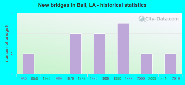
- New bridges - historical statistics
- 21950-1959
- 41970-1979
- 41980-1989
- 51990-1999
- 22000-2009
- 22010-2019


- Bridge Condition - Deck
- 11.8%Very good
- 41.2%Good
- 17.6%Satisfactory
- 17.6%Fair
- 11.8%Poor

- Bridge Condition - Superstructure
- 11.8%Very good
- 41.2%Good
- 17.6%Satisfactory
- 17.6%Fair
- 11.8%Poor

- Bridge Condition - Substructure
- 11.8%Very good
- 47.1%Good
- 17.6%Satisfactory
- 5.9%Fair
- 11.8%Poor
- 5.9%Serious

- Bridge Condition - Channel
- 11.1%Very good
- 16.7%Good
- 50.0%Satisfactory
- 22.2%Fair
Find on map >> Show street view
Structure Number: 80601000002187, Location: NO DATA ENTERED (Lat: 31.447192, Lng: -92.340786), Route carried "on" structure: Federal lands road 141, Year Built: 2001, Status: Open, Structure Length: 1.74m (5.71ft), Average Daily Traffic: 30 (year 2001), Average Future Daily Traffic: 45 (year 2042), Design Load: HS 20, Features Intersected: BEAVER CREEK
Minimum Vertical Clearance: 30+ m (98+ ft), Kilometerpoint: 6.560, Lanes on structure: 2, Owner: U.S. Forest Service, Approaching Roadway Width: 7.3m (24.0ft), Material/Design: Concrete, Design/Construction: Slab, Number Of Spans In Main Unit: 3, Length of Maximum Span: 5.8m (19.0ft), Curb-To-Curb Width: 7.3m (24.0ft), Out-to-Out Width: 8.2m (26.9ft)
Condition: Deck: Good, Superstructure: Good, Substructure: Very good, Channel: Good, Operating Rating: 26.9 metric tons, Method Used To Determine Operating Rating: Load and Resistance Factor Rating (LRFR) rating reported by rating factor(RF) method using HL-93 loadings, Inventory Rating: 20.7 metric tons, Method Used To Determine Inventory Rating: Load and Resistance Factor Rating (LRFR) rating reported by rating factor(RF) method using HL-93 loadings, Structural Evaluation: Equal to present minimum criteria, Deck Geometry: Equal to present minimum criteria, Waterway Adequacy: Equal to present desirable criteria, Approach Roadway Alignment: Equal to present desirable criteria, Designated Inspection Frequency: Every 24 months, Inspection Date: November 2020, Deck Structure Type: Other, Wearing Surface/Protective System: Wearing Surface: Integral Concrete
Find on map >> Show street view
Structure Number: 822000007007, Location: 1.0 MILES W US 165 (Lat: 31.440911, Lng: -92.422000), Route carried "on" structure: County highway , Year Built: 2009, Status: Open, Structure Length: 1.83m (6.00ft), Average Daily Traffic: 175 (year 2005), Truck Traffic: 1%, Average Future Daily Traffic: 294 (year 2036), Design Load: HS 20, Features Intersected: KITCHEN CREEK, Facility Carried by Structure: Robertson Rd
Minimum Vertical Clearance: 30+ m (98+ ft), Kilometerpoint: 1.085, Lanes on structure: 2, Owner: County Highway Agency, Approaching Roadway Width: 7.3m (24.0ft), Skew: 30 degrees, Material/Design: Concrete, Design/Construction: Slab, Number Of Spans In Main Unit: 3, Length of Maximum Span: 6.1m (20.0ft), Curb-To-Curb Width: 7.1m (23.3ft), Out-to-Out Width: 8.2m (26.9ft)
Condition: Deck: Very good, Superstructure: Very good, Substructure: Very good, Channel: Very good, Operating Rating: 42.1 metric tons, Method Used To Determine Operating Rating: Load and Resistance Factor Rating (LRFR) rating reported by rating factor(RF) method using HL-93 loadings, Inventory Rating: 32.7 metric tons, Method Used To Determine Inventory Rating: Load and Resistance Factor Rating (LRFR) rating reported by rating factor(RF) method using HL-93 loadings, Structural Evaluation: Equal to present desirable criteria, Deck Geometry: Meets minimum limits, Waterway Adequacy: Equal to present desirable criteria, Approach Roadway Alignment: Equal to present minimum criteria, Designated Inspection Frequency: Every 24 months, Inspection Date: April 2021, Deck Structure Type: Concrete Cast-file-Place, Wearing Surface/Protective System: Wearing Surface: Monolithic Concrete
Find on map >> Show street view
Structure Number: 82200150300551, Location: .55 MI SOUTH OF LA 3130 (Lat: 31.443939, Lng: -92.409800), Route carried "on" structure: US 165, Year Built: 1986, Status: Open, Structure Length: 0.76m (2.49ft), Average Daily Traffic: 7,100 (year 2016), Truck Traffic: 15%, Average Future Daily Traffic: 11,928 (year 2036), Design Load: HS 20, Features Intersected: SMALL CREEK
Minimum Vertical Clearance: 30+ m (98+ ft), Kilometerpoint: 0.779, Lanes on structure: 4, Base Highway Network: Yes (Inventory Route: 15-03-1, Subroute: 10), Owner: State Highway Agency, Approaching Roadway Width: 23.2m (76.1ft), Skew: 30 degrees, Material/Design: Concrete, Design/Construction: Culvert, Number Of Spans In Main Unit: 4, Length of Maximum Span: 1.8m (5.9ft)
Condition: Channel: Satisfactory, Culverts: Satisfactory, Operating Rating: 42.1 metric tons, Method Used To Determine Operating Rating: Load and Resistance Factor Rating (LRFR) rating reported by rating factor(RF) method using HL-93 loadings, Inventory Rating: 32.4 metric tons, Method Used To Determine Inventory Rating: Load and Resistance Factor Rating (LRFR) rating reported by rating factor(RF) method using HL-93 loadings, Structural Evaluation: Equal to present minimum criteria, Waterway Adequacy: Better than present minimum criteria, Approach Roadway Alignment: Equal to present desirable criteria, Designated Inspection Frequency: Every 24 months, Inspection Date: September 2020, Deck Structure Type: Concrete Cast-file-Place
Find on map >> Show street view
Structure Number: 82231289922111, Location: 2.64 M. NE OF US 165 (Lat: 31.481300, Lng: -92.370100), Route carried "on" structure: County highway , Year Built: 1997, Status: Open, Structure Length: 2.32m (7.61ft), Average Daily Traffic: 30 (year 2016), Average Future Daily Traffic: 50 (year 2036), Design Load: HS 20, Features Intersected: CLEAR CREEK, Facility Carried by Structure: Barron Rd
Minimum Vertical Clearance: 30+ m (98+ ft), Kilometerpoint: 4.527, Lanes on structure: 2, Owner: County Highway Agency, Approaching Roadway Width: 8.5m (27.9ft), Skew: 30 degrees, Material/Design: Concrete, Design/Construction: Slab, Number Of Spans In Main Unit: 4, Length of Maximum Span: 5.8m (19.0ft), Curb-To-Curb Width: 7.3m (24.0ft), Out-to-Out Width: 8.2m (26.9ft)
Condition: Deck: Very good, Superstructure: Very good, Substructure: Good, Channel: Very good, Operating Rating: 53.5 metric tons, Method Used To Determine Operating Rating: Load and Resistance Factor Rating (LRFR) rating reported by rating factor(RF) method using HL-93 loadings, Inventory Rating: 41.1 metric tons, Method Used To Determine Inventory Rating: Load and Resistance Factor Rating (LRFR) rating reported by rating factor(RF) method using HL-93 loadings, Structural Evaluation: Better than present minimum criteria, Deck Geometry: Equal to present minimum criteria, Waterway Adequacy: Equal to present desirable criteria, Approach Roadway Alignment: Equal to present minimum criteria, Designated Inspection Frequency: Every 24 months, Inspection Date: April 2021, Deck Structure Type: Concrete Precast Panels, Wearing Surface/Protective System: Wearing Surface: Monolithic Concrete
Find on map >> Show street view
Structure Number: 84000000080579, Location: 0.41 MI. EAST OF LA 3225 (Lat: 31.388031, Lng: -92.428900), Route carried "on" structure: State highway 623, Year Built: 2011, Status: Open, Structure Length: 20.57m (67.49ft), Average Daily Traffic: 3,900 (year 2016), Truck Traffic: 4%, Average Future Daily Traffic: 4,940 (year 2036), Design Load: HS 20, Features Intersected: FR. RD, KCS RR, UP RR
Minimum Vertical Clearance: 30+ m (98+ ft), Kilometerpoint: 0.658, Lanes on structure: 3, Lanes under structure: 2, Owner: State Highway Agency, Approaching Roadway Width: 12.8m (42.0ft), Skew: 30 degrees, Material/Design: Prestressed concrete continuous, Design/Construction: Stringer/Multi-beam, Number Of Spans In Main Unit: 9, Length of Maximum Span: 22.9m (75.1ft), Curb or Sidewalk Widths: Left: 1.8m (5.9ft), Right: 1.8m (5.9ft), Curb-To-Curb Width: 12.8m (42.0ft), Out-to-Out Width: 17.1m (56.1ft)
Condition: Deck: Good, Superstructure: Good, Substructure: Good, Operating Rating: 59.6 metric tons, Method Used To Determine Operating Rating: Load and Resistance Factor Rating (LRFR) rating reported by rating factor(RF) method using HL-93 loadings, Inventory Rating: 32.1 metric tons, Method Used To Determine Inventory Rating: Load and Resistance Factor Rating (LRFR) rating reported by rating factor(RF) method using HL-93 loadings, Structural Evaluation: Better than present minimum criteria, Deck Geometry: Meets minimum limits, Underclear: Better than present minimum criteria, Approach Roadway Alignment: Better than present minimum criteria, Designated Inspection Frequency: Every 24 months, Inspection Date: November 2020, Deck Structure Type: Concrete Cast-file-Place, Wearing Surface/Protective System: Wearing Surface: Monolithic Concrete
Find on map >> Show street view
Structure Number: 8400000008067, Location: 0.6 M E OF US 165 (Lat: 31.391789, Lng: -92.400900), Route carried "on" structure: State highway 623, Year Built: 2019, Status: Open, Structure Length: 6.71m (22.01ft), Average Daily Traffic: 1,850 (year 2017), Truck Traffic: 4%, Average Future Daily Traffic: 2,250 (year 2037), Design Load: Greater than HL93, Features Intersected: FLAGON BAYOU
Minimum Vertical Clearance: 30+ m (98+ ft), Kilometerpoint: 0.978, Lanes on structure: 2, Owner: State Highway Agency, Approaching Roadway Width: 12.2m (40.0ft), Material/Design: Concrete, Design/Construction: Slab, Number Of Spans In Main Unit: 11, Length of Maximum Span: 6.1m (20.0ft), Curb-To-Curb Width: 12.0m (39.4ft), Out-to-Out Width: 13.0m (42.7ft)
Condition: Deck: Good, Superstructure: Good, Substructure: Good, Channel: Satisfactory, Operating Rating: 59.3 metric tons, Method Used To Determine Operating Rating: Load and Resistance Factor Rating (LRFR) rating reported by rating factor(RF) method using HL-93 loadings, Inventory Rating: 45.7 metric tons, Method Used To Determine Inventory Rating: Load and Resistance Factor Rating (LRFR) rating reported by rating factor(RF) method using HL-93 loadings, Structural Evaluation: Better than present minimum criteria, Deck Geometry: Equal to present minimum criteria, Waterway Adequacy: Equal to present desirable criteria, Approach Roadway Alignment: Equal to present minimum criteria, Designated Inspection Frequency: Every 24 months, Inspection Date: December 2020, Deck Structure Type: Concrete Cast-file-Place
Find on map >> Show street view
Structure Number: 84000150202091, Location: 0.44 M. N. OF JCT LA 623 (Lat: 31.395311, Lng: -92.409300), Route carried "on" structure: US 165, Year Built: 1956, Year Reconstructed: 1984, Status: Open, Structure Length: 4.27m (14.01ft), Average Daily Traffic: 10,150 (year 2016), Truck Traffic: 14%, Average Future Daily Traffic: 15,756 (year 2036), Design Load: HS 20, Features Intersected: FLAGON BAYOU RELIEF
Minimum Vertical Clearance: 30+ m (98+ ft), Kilometerpoint: 3.566, Lanes on structure: 2, Base Highway Network: Yes (Inventory Route: 15-02-1, Subroute: 10), Owner: State Highway Agency, Approaching Roadway Width: 12.2m (40.0ft), Skew: 30 degrees, Material/Design: Concrete, Design/Construction: Slab, Number Of Spans In Main Unit: 7, Length of Maximum Span: 6.1m (20.0ft), Curb-To-Curb Width: 12.2m (40.0ft), Out-to-Out Width: 13.0m (42.7ft)
Condition: Deck: Satisfactory, Superstructure: Satisfactory, Substructure: Satisfactory, Channel: Satisfactory, Operating Rating: 33.6 metric tons, Method Used To Determine Operating Rating: Load Factor (LF), Inventory Rating: 20.0 metric tons, Method Used To Determine Inventory Rating: Load Factor (LF), Structural Evaluation: Somewhat better than minimum adequacy, Deck Geometry: Better than present minimum criteria, Waterway Adequacy: Equal to present minimum criteria, Approach Roadway Alignment: Equal to present desirable criteria, Designated Inspection Frequency: Every 24 months, Inspection Date: June 2020, Deck Structure Type: Concrete Cast-file-Place, Wearing Surface/Protective System: Wearing Surface: Bituminous
Find on map >> Show street view
Structure Number: 84000150202092, Location: 0.44 MI. NORTH OF LA 623 (Lat: 31.395639, Lng: -92.409600), Route carried "on" structure: US 165, Year Built: 1984, Status: Open, Structure Length: 4.27m (14.01ft), Average Daily Traffic: 10,150 (year 2016), Truck Traffic: 14%, Average Future Daily Traffic: 15,756 (year 2036), Design Load: HS 20, Features Intersected: FLAGON BAYOU RELIEF
Minimum Vertical Clearance: 30+ m (98+ ft), Kilometerpoint: 4.604, Lanes on structure: 2, Base Highway Network: Yes (Inventory Route: 15-02-2, Subroute: 10), Owner: State Highway Agency, Approaching Roadway Width: 12.2m (40.0ft), Skew: 30 degrees, Material/Design: Concrete, Design/Construction: Slab, Number Of Spans In Main Unit: 7, Length of Maximum Span: 6.1m (20.0ft), Curb-To-Curb Width: 12.2m (40.0ft), Out-to-Out Width: 13.0m (42.7ft)
Condition: Deck: Good, Superstructure: Good, Substructure: Good, Channel: Satisfactory, Operating Rating: 68.0 metric tons, Method Used To Determine Operating Rating: Load Factor (LF), Inventory Rating: 40.8 metric tons, Method Used To Determine Inventory Rating: Load Factor (LF), Structural Evaluation: Better than present minimum criteria, Deck Geometry: Better than present minimum criteria, Waterway Adequacy: Equal to present minimum criteria, Approach Roadway Alignment: Equal to present desirable criteria, Designated Inspection Frequency: Every 24 months, Inspection Date: June 2020, Deck Structure Type: Concrete Cast-file-Place, Wearing Surface/Protective System: Wearing Surface: Monolithic Concrete
Find on map >> Show street view
Structure Number: 84000150202261, Location: 0.61 MI. NORTH OF LA 623 (Lat: 31.397731, Lng: -92.409800), Route carried "on" structure: US 165, Year Built: 1956, Year Reconstructed: 1984, Status: Open, Structure Length: 4.27m (14.01ft), Average Daily Traffic: 10,150 (year 2016), Truck Traffic: 14%, Average Future Daily Traffic: 15,756 (year 2036), Design Load: HS 20, Features Intersected: FLAGON BAYOU
Minimum Vertical Clearance: 30+ m (98+ ft), Kilometerpoint: 3.838, Lanes on structure: 2, Base Highway Network: Yes (Inventory Route: 15-02-1, Subroute: 10), Owner: State Highway Agency, Approaching Roadway Width: 12.2m (40.0ft), Skew: 30 degrees, Material/Design: Concrete, Design/Construction: Slab, Number Of Spans In Main Unit: 7, Length of Maximum Span: 6.1m (20.0ft), Curb-To-Curb Width: 12.2m (40.0ft), Out-to-Out Width: 13.0m (42.7ft)
Condition: Deck: Satisfactory, Superstructure: Satisfactory, Substructure: Satisfactory, Channel: Satisfactory, Operating Rating: 33.6 metric tons, Method Used To Determine Operating Rating: Load Factor (LF), Inventory Rating: 20.0 metric tons, Method Used To Determine Inventory Rating: Load Factor (LF), Structural Evaluation: Somewhat better than minimum adequacy, Deck Geometry: Better than present minimum criteria, Waterway Adequacy: Better than present minimum criteria, Approach Roadway Alignment: Equal to present desirable criteria, Designated Inspection Frequency: Every 24 months, Inspection Date: June 2020, Deck Structure Type: Concrete Cast-file-Place, Wearing Surface/Protective System: Wearing Surface: Bituminous
Find on map >> Show street view
Structure Number: 84000150202262, Location: 0.61 MI. NORTH OF LA 623 (Lat: 31.398069, Lng: -92.410100), Route carried "on" structure: US 165, Year Built: 1984, Status: Open, Structure Length: 4.27m (14.01ft), Average Daily Traffic: 10,150 (year 2016), Truck Traffic: 14%, Average Future Daily Traffic: 15,756 (year 2036), Design Load: HS 20, Features Intersected: FLAGON BAYOU
Minimum Vertical Clearance: 30+ m (98+ ft), Kilometerpoint: 4.331, Lanes on structure: 2, Base Highway Network: Yes (Inventory Route: 15-02-2, Subroute: 10), Owner: State Highway Agency, Approaching Roadway Width: 12.2m (40.0ft), Skew: 30 degrees, Material/Design: Concrete, Design/Construction: Slab, Number Of Spans In Main Unit: 7, Length of Maximum Span: 6.1m (20.0ft), Curb-To-Curb Width: 12.2m (40.0ft), Out-to-Out Width: 13.0m (42.7ft)
Condition: Deck: Good, Superstructure: Good, Substructure: Good, Channel: Satisfactory, Operating Rating: 68.0 metric tons, Method Used To Determine Operating Rating: Load Factor (LF), Inventory Rating: 40.8 metric tons, Method Used To Determine Inventory Rating: Load Factor (LF), Structural Evaluation: Better than present minimum criteria, Deck Geometry: Better than present minimum criteria, Waterway Adequacy: Equal to present minimum criteria, Approach Roadway Alignment: Equal to present desirable criteria, Designated Inspection Frequency: Every 24 months, Inspection Date: June 2020, Deck Structure Type: Concrete Cast-file-Place, Wearing Surface/Protective System: Wearing Surface: Monolithic Concrete
Find on map >> Show street view
Structure Number: 84001400200221, Location: 0.79 MI. WEST OF LA 462 (Lat: 30.974561, Lng: -92.822300), Route carried "on" structure: State highway 113, Year Built: 1984, Status: Open, Structure Length: 4.57m (14.99ft), Average Daily Traffic: 720 (year 2016), Truck Traffic: 14%, Average Future Daily Traffic: 936 (year 2036), Design Load: HS 20, Features Intersected: TEN MILE CREEK RELIEF
Minimum Vertical Clearance: 30+ m (98+ ft), Kilometerpoint: 0.180, Lanes on structure: 2, Owner: State Highway Agency, Approaching Roadway Width: 7.9m (25.9ft), Skew: 30 degrees, Material/Design: Concrete, Design/Construction: Slab, Number Of Spans In Main Unit: 6, Length of Maximum Span: 7.6m (24.9ft), Curb-To-Curb Width: 12.2m (40.0ft), Out-to-Out Width: 13.0m (42.7ft)
Condition: Deck: Satisfactory, Superstructure: Satisfactory, Substructure: Good, Channel: Satisfactory, Operating Rating: 76.2 metric tons, Method Used To Determine Operating Rating: Load Factor (LF), Inventory Rating: 45.4 metric tons, Method Used To Determine Inventory Rating: Load Factor (LF), Structural Evaluation: Equal to present minimum criteria, Deck Geometry: Equal to present desirable criteria, Waterway Adequacy: Better than present minimum criteria, Approach Roadway Alignment: Better than present minimum criteria, Designated Inspection Frequency: Every 24 months, Inspection Date: November 2020, Deck Structure Type: Concrete Cast-file-Place, Wearing Surface/Protective System: Wearing Surface: Monolithic Concrete
Find on map >> Show street view
Structure Number: 84001493001241, Location: 1.24 MI EAST JCT US 165 (Lat: 31.416100, Lng: -92.390800), Route carried "on" structure: State highway 1204, Year Built: 1996, Status: Open, Structure Length: 3.66m (12.01ft), Average Daily Traffic: 1,730 (year 2016), Truck Traffic: 10%, Average Future Daily Traffic: 2,249 (year 2036), Design Load: HS 20, Features Intersected: HAW CREEK
Minimum Vertical Clearance: 30+ m (98+ ft), Kilometerpoint: 4.023, Lanes on structure: 2, Owner: State Highway Agency, Approaching Roadway Width: 13.4m (44.0ft), Skew: 30 degrees, Material/Design: Concrete, Design/Construction: Slab, Number Of Spans In Main Unit: 6, Length of Maximum Span: 6.1m (20.0ft), Curb-To-Curb Width: 13.3m (43.6ft), Out-to-Out Width: 14.3m (46.9ft)
Condition: Deck: Good, Superstructure: Good, Substructure: Good, Channel: Satisfactory, Operating Rating: 73.5 metric tons, Method Used To Determine Operating Rating: Load Factor (LF), Inventory Rating: 43.5 metric tons, Method Used To Determine Inventory Rating: Load Factor (LF), Structural Evaluation: Better than present minimum criteria, Deck Geometry: Better than present minimum criteria, Waterway Adequacy: Equal to present desirable criteria, Approach Roadway Alignment: Equal to present desirable criteria, Designated Inspection Frequency: Every 24 months, Inspection Date: November 2020, Deck Structure Type: Concrete Cast-file-Place, Wearing Surface/Protective System: Wearing Surface: Monolithic Concrete
Find on map >> Show street view
Structure Number: 84008403101291, Location: 1.29 MI. E OF LA3225 (Lat: 31.416081, Lng: -92.434000), Route carried "on" structure: State highway 1204, Year Built: 1973, Status: Open, Structure Length: 2.35m (7.71ft), Average Daily Traffic: 2,900 (year 2016), Truck Traffic: 8%, Average Future Daily Traffic: 3,900 (year 2036), Design Load: HS 20, Features Intersected: FLAGON BAYOU
Minimum Vertical Clearance: 30+ m (98+ ft), Kilometerpoint: 2.058, Lanes on structure: 2, Owner: State Highway Agency, Approaching Roadway Width: 10.4m (34.1ft), Skew: 30 degrees, Material/Design: Wood or Timber, Design/Construction: Stringer/Multi-beam, Number Of Spans In Main Unit: 4, Length of Maximum Span: 5.8m (19.0ft), Curb-To-Curb Width: 8.8m (28.9ft), Out-to-Out Width: 9.4m (30.8ft)
Condition: Deck: Poor, Superstructure: Poor, Substructure: Poor, Channel: Fair, Operating Rating: 29.0 metric tons, Method Used To Determine Operating Rating: Allowable Stress (AS), Inventory Rating: 20.4 metric tons, Method Used To Determine Inventory Rating: Allowable Stress (AS), Structural Evaluation: Meets minimum limits, Deck Geometry: Meets minimum limits, Waterway Adequacy: Equal to present minimum criteria, Approach Roadway Alignment: Meets minimum limits, Length Of Structure Improvement: 3.11m (10.20ft), Designated Inspection Frequency: Every 24 months, Other Special Inspection Frequency: Every 12 months, Inspection Date: December 2020, Other Special Inspection Date: December 2021, Bridge Improvement Cost: $265,000, Total Project Cost: $397,000 ( Estimate for 2016), Deck Structure Type: Wood or Timber, Wearing Surface/Protective System: Wearing Surface: Bituminous
Find on map >> Show street view
Structure Number: 84008403101381, Location: 1.38 MI. E OF LA3225 (Lat: 31.417369, Lng: -92.433900), Route carried "on" structure: State highway 1204, Year Built: 1973, Status: Open, Structure Length: 1.77m (5.81ft), Average Daily Traffic: 2,200 (year 2018), Truck Traffic: 8%, Average Future Daily Traffic: 3,900 (year 2036), Design Load: HS 20, Features Intersected: FLAGON BAYOU
Minimum Vertical Clearance: 30+ m (98+ ft), Kilometerpoint: 2.202, Lanes on structure: 2, Owner: State Highway Agency, Approaching Roadway Width: 10.4m (34.1ft), Skew: 30 degrees, Material/Design: Wood or Timber, Design/Construction: Stringer/Multi-beam, Number Of Spans In Main Unit: 3, Length of Maximum Span: 5.8m (19.0ft), Curb-To-Curb Width: 8.8m (28.9ft), Out-to-Out Width: 9.4m (30.8ft)
Condition: Deck: Poor, Superstructure: Poor, Substructure: Fair, Channel: Fair, Operating Rating: 27.2 metric tons, Method Used To Determine Operating Rating: Allowable Stress (AS), Inventory Rating: 19.0 metric tons, Method Used To Determine Inventory Rating: Allowable Stress (AS), Structural Evaluation: Meets minimum limits, Deck Geometry: Meets minimum limits, Waterway Adequacy: Equal to present minimum criteria, Approach Roadway Alignment: High priority of corrective action, Length Of Structure Improvement: 2.47m (8.10ft), Designated Inspection Frequency: Every 24 months, Other Special Inspection Frequency: Every 12 months, Inspection Date: December 2020, Other Special Inspection Date: December 2021, Bridge Improvement Cost: $210,000, Total Project Cost: $315,000 ( Estimate for 2016), Deck Structure Type: Wood or Timber, Wearing Surface/Protective System: Wearing Surface: Bituminous
Find on map >> Show street view
Structure Number: 84008403101711, Location: 1.71 MI. E OF LA3225 (Lat: 31.417161, Lng: -92.428900), Route carried "on" structure: State highway 1204, Year Built: 1973, Status: Posted for load, Structure Length: 1.77m (5.81ft), Average Daily Traffic: 2,900 (year 2016), Truck Traffic: 8%, Average Future Daily Traffic: 3,900 (year 2036), Design Load: HS 20, Features Intersected: KITCHEN CREEK
Minimum Vertical Clearance: 30+ m (98+ ft), Kilometerpoint: 2.737, Lanes on structure: 2, Owner: State Highway Agency, Approaching Roadway Width: 10.4m (34.1ft), Skew: 30 degrees, Material/Design: Wood or Timber, Design/Construction: Stringer/Multi-beam, Number Of Spans In Main Unit: 3, Length of Maximum Span: 5.8m (19.0ft), Curb-To-Curb Width: 8.8m (28.9ft), Out-to-Out Width: 9.4m (30.8ft)
Condition: Deck: Fair, Superstructure: Fair, Substructure: Poor, Channel: Fair, Operating Rating: 24.5 metric tons, Method Used To Determine Operating Rating: Allowable Stress (AS), Inventory Rating: 18.1 metric tons, Method Used To Determine Inventory Rating: Allowable Stress (AS), Structural Evaluation: Meets minimum limits, Deck Geometry: Meets minimum limits, Waterway Adequacy: Equal to present minimum criteria, Approach Roadway Alignment: Equal to present desirable criteria, Bridge Posting: Required (Relationship of Operating Rating to Maximum Legal Load: 0.1 - 9.9% below), Length Of Structure Improvement: 2.47m (8.10ft), Designated Inspection Frequency: Every 24 months, Other Special Inspection Frequency: Every 12 months, Inspection Date: December 2020, Other Special Inspection Date: December 2021, Bridge Improvement Cost: $210,000, Total Project Cost: $315,000 ( Estimate for 2016), Deck Structure Type: Wood or Timber, Wearing Surface/Protective System: Wearing Surface: Bituminous
Find on map >> Show street view
Structure Number: 84031203921801, Location: 2.01 MI. SOUTH OF LA 28 (Lat: 31.338381, Lng: -92.300900), Route carried "on" structure: County highway , Year Built: 1990, Status: Open, Structure Length: 0.70m (2.30ft), Average Daily Traffic: 150 (year 1976), Average Future Daily Traffic: 195 (year 2036), Design Load: HS 20, Features Intersected: HAINES CREEK, Facility Carried by Structure: Gunter Rd
Minimum Vertical Clearance: 30+ m (98+ ft), Kilometerpoint: 0.674, Lanes on structure: 2, Owner: County Highway Agency, Approaching Roadway Width: 7.3m (24.0ft), Skew: 37 degrees, Material/Design: Steel, Design/Construction: Culvert, Number Of Spans In Main Unit: 3, Length of Maximum Span: 1.8m (5.9ft)
Condition: Channel: Satisfactory, Culverts: Satisfactory, Operating Rating: 97.2 metric tons, Method Used To Determine Operating Rating: Load and Resistance Factor Rating (LRFR) rating reported by rating factor(RF) method using HL-93 loadings, Inventory Rating: 74.5 metric tons, Method Used To Determine Inventory Rating: Load and Resistance Factor Rating (LRFR) rating reported by rating factor(RF) method using HL-93 loadings, Structural Evaluation: Equal to present minimum criteria, Waterway Adequacy: Equal to present minimum criteria, Approach Roadway Alignment: Better than present minimum criteria, Designated Inspection Frequency: Every 24 months, Inspection Date: April 2021
Find on map >> Show street view
Structure Number: 84031238922381, Location: .70 MI E OF LA 623 (Lat: 31.395800, Lng: -92.388200), Route carried "on" structure: County highway , Year Built: 1999, Status: Open, Structure Length: 2.90m (9.51ft), Average Daily Traffic: 1,000 (year 1998), Average Future Daily Traffic: 1,300 (year 2036), Design Load: HS 20, Features Intersected: HAW CREEK, Facility Carried by Structure: Washboard Rd
Minimum Vertical Clearance: 30+ m (98+ ft), Kilometerpoint: 1.125, Lanes on structure: 2, Owner: County Highway Agency, Approaching Roadway Width: 6.4m (21.0ft), Skew: 37 degrees, Material/Design: Concrete, Design/Construction: Slab, Number Of Spans In Main Unit: 5, Length of Maximum Span: 5.8m (19.0ft), Curb-To-Curb Width: 8.5m (27.9ft), Out-to-Out Width: 9.4m (30.8ft)
Condition: Deck: Good, Superstructure: Good, Substructure: Good, Channel: Good, Operating Rating: 36.0 metric tons, Method Used To Determine Operating Rating: Load and Resistance Factor Rating (LRFR) rating reported by rating factor(RF) method using HL-93 loadings, Inventory Rating: 27.9 metric tons, Method Used To Determine Inventory Rating: Load and Resistance Factor Rating (LRFR) rating reported by rating factor(RF) method using HL-93 loadings, Structural Evaluation: Better than present minimum criteria, Deck Geometry: Somewhat better than minimum adequacy, Waterway Adequacy: Superior to present desirable criteria, Approach Roadway Alignment: Better than present minimum criteria, Designated Inspection Frequency: Every 24 months, Inspection Date: July 2021, Deck Structure Type: Concrete Cast-file-Place, Wearing Surface/Protective System: Wearing Surface: Monolithic Concrete
Find on map >> Show street view
Structure Number: 84031244922481, Location: 0.14 MI. WEST OF US 165 (Lat: 31.406231, Lng: -92.413900), Route carried "on" structure: County highway , Year Built: 1970, Status: Posted for load, Structure Length: 0.94m (3.08ft), Average Daily Traffic: 200 (year 1980), Average Future Daily Traffic: 260 (year 2036), Design Load: HS 20, Features Intersected: FLAGON BAYOU TRIB., Facility Carried by Structure: Beeson St
Minimum Vertical Clearance: 30+ m (98+ ft), Kilometerpoint: 0.217, Lanes on structure: 2, Owner: Town or Township Highway Agency, Approaching Roadway Width: 8.5m (27.9ft), Skew: 30 degrees, Material/Design: Prestressed concrete, Design/Construction: Channel Beam, Number Of Spans In Main Unit: 2, Length of Maximum Span: 4.6m (15.1ft), Curb-To-Curb Width: 6.4m (21.0ft), Out-to-Out Width: 6.8m (22.3ft)
Condition: Deck: Fair, Superstructure: Fair, Substructure: Serious, Channel: Fair, Operating Rating: 12.6 metric tons, Method Used To Determine Operating Rating: Load and Resistance Factor Rating (LRFR) rating reported by rating factor(RF) method using HL-93 loadings, Inventory Rating: 9.7 metric tons, Method Used To Determine Inventory Rating: Load and Resistance Factor Rating (LRFR) rating reported by rating factor(RF) method using HL-93 loadings, Structural Evaluation: High priority of corrective action, Deck Geometry: Meets minimum limits, Waterway Adequacy: Superior to present desirable criteria, Approach Roadway Alignment: Equal to present minimum criteria, Bridge Posting: Required (Relationship of Operating Rating to Maximum Legal Load: > 39.9% below), Designated Inspection Frequency: Every 24 months, Other Special Inspection Frequency: Every 6 months, Inspection Date: April 2021, Other Special Inspection Date: October 2021, Deck Structure Type: Concrete Precast Panels, Wearing Surface/Protective System: Wearing Surface: Bituminous
Find on map >> Show street view
Structure Number: 84031253922751, Location: 0.76 MI. NORTH OF LA 3225 (Lat: 31.418819, Lng: -92.458800), Route carried "on" structure: County highway , Year Built: 1990, Status: Open, Structure Length: 4.05m (13.29ft), Average Daily Traffic: 1,200 (year 1988), Average Future Daily Traffic: 1,560 (year 2036), Design Load: HS 20, Features Intersected: FLAGON BAYOU, Facility Carried by Structure: Hooper Rd
Minimum Vertical Clearance: 30+ m (98+ ft), Kilometerpoint: 0.922, Lanes on structure: 2, Owner: County Highway Agency, Approaching Roadway Width: 9.1m (29.9ft), Skew: 30 degrees, Material/Design: Concrete, Design/Construction: Slab, Number Of Spans In Main Unit: 7, Length of Maximum Span: 5.8m (19.0ft), Curb-To-Curb Width: 8.5m (27.9ft), Out-to-Out Width: 9.4m (30.8ft)
Condition: Deck: Fair, Superstructure: Fair, Substructure: Satisfactory, Channel: Good, Operating Rating: 36.0 metric tons, Method Used To Determine Operating Rating: Load and Resistance Factor Rating (LRFR) rating reported by rating factor(RF) method using HL-93 loadings, Inventory Rating: 27.9 metric tons, Method Used To Determine Inventory Rating: Load and Resistance Factor Rating (LRFR) rating reported by rating factor(RF) method using HL-93 loadings, Structural Evaluation: Somewhat better than minimum adequacy, Deck Geometry: Somewhat better than minimum adequacy, Waterway Adequacy: Superior to present desirable criteria, Approach Roadway Alignment: Equal to present desirable criteria, Designated Inspection Frequency: Every 24 months, Inspection Date: July 2021, Deck Structure Type: Concrete Cast-file-Place, Wearing Surface/Protective System: Wearing Surface: Monolithic Concrete
Find on map >> Show street view
Structure Number: 84000230107701, Location: 0.02 MI S OF LA 3225 (Lat: 31.380589, Lng: -92.434919), Route carried "under" structure: US 71, Structure Length: 0. m, Average Daily Traffic: 3,800 (year 2016), Features Intersected: US 71 SB UNDER US 167 NB
Minimum Vertical Clearance: 5.15m (16.90ft), Kilometerpoint: 0.185, Lanes on structure: 2, Lanes under structure: 2, Length of Maximum Span: 0.0m
Find on map >> Show street view
Structure Number: 84000230107701, Location: 1.6 MI N OF LA 1203 (Lat: 31.380419, Lng: -92.434911), Route carried "under" structure: US 71, Structure Length: 0. m, Average Daily Traffic: 3,800 (year 2016), Features Intersected: US 71 NB UNDER US 167 NB
Minimum Vertical Clearance: 5.18m (16.99ft), Kilometerpoint: 9.503, Lanes on structure: 2, Lanes under structure: 2, Length of Maximum Span: 0.0m
Find on map >> Show street view
Structure Number: 84000230107702, Location: 0.135 MI S OF LA 3225 (Lat: 31.380361, Lng: -92.435111), Route carried "under" structure: US 71, Structure Length: 0. m, Average Daily Traffic: 3,800 (year 2016), Features Intersected: US 71 SB UNDER US 167 SB
Minimum Vertical Clearance: 5.33m (17.49ft), Kilometerpoint: 0.217, Lanes on structure: 2, Lanes under structure: 2, Length of Maximum Span: 0.0m
Find on map >> Show street view
Structure Number: 84000230107702, Location: 5.85 MI N OF LA 1203 (Lat: 31.380239, Lng: -92.435050), Route carried "under" structure: US 71, Structure Length: 0. m, Average Daily Traffic: 3,800 (year 2016), Features Intersected: US 71 NB UNDER US 167 SB
Minimum Vertical Clearance: 5.67m (18.60ft), Kilometerpoint: 9.479, Lanes on structure: 2, Lanes under structure: 2, Length of Maximum Span: 0.0m
Find on map >> Show street view
Structure Number: 84000230108501, Location: 0.6 MI N OF US 71 (Lat: 31.387950, Lng: -92.436869), Route carried "under" structure: US 167, Structure Length: 0. m, Average Daily Traffic: 7,750 (year 2016), Features Intersected: US 167 NB UNDER HICKORY
Minimum Vertical Clearance: 4.88m (16.01ft), Kilometerpoint: 13.757, Lanes on structure: 2, Lanes under structure: 2, Length of Maximum Span: 0.0m
Find on map >> Show street view
Structure Number: 84000230108501, Location: 2.2 MI S OF US 71 (Lat: 31.388061, Lng: -92.441661), Route carried "under" structure: US 167, Structure Length: 0. m, Average Daily Traffic: 7,750 (year 2016), Features Intersected: US 167 SB UNDER HICKORY
Minimum Vertical Clearance: 4.94m (16.21ft), Kilometerpoint: 5.425, Lanes on structure: 2, Lanes under structure: 2, Length of Maximum Span: 0.0m