Bridge Statistics for Bagdad, Arizona (AZ)
Condition, Traffic, Stress, Structural Evaluation, Project Costs
- National Bridge Inventory (NBI) Statistics
- 10Number of bridges
- 115ft / 35.1mTotal length
- 23,647Total average daily traffic
- 2,040Total average daily truck traffic
- 23,797Total future (year 2038) average daily traffic
- National Bridge Inventory (NBI) Registered Bridges for Bagdad
- No street view available for this location
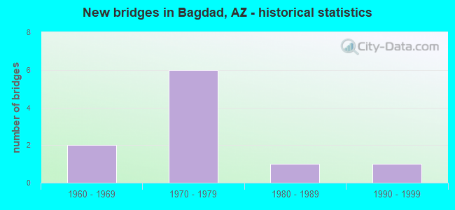
- New bridges - historical statistics
- 21960-1969
- 61970-1979
- 11980-1989
- 11990-1999


- Bridge Condition - Deck
- 50.0%Very good
- 25.0%Satisfactory
- 25.0%Poor

- Bridge Condition - Substructure
- 75.0%Good
- 25.0%Satisfactory

- Bridge Condition - Culverts
- 83.3%Good
- 16.7%Satisfactory
Find on map >> Show street view
Structure Number: 123, Location: 6.9 mi East Jct US191 (Lat: 32.329000, Lng: -109.513000), Route carried "on" structure: Business State highway 10, Year Built: 1967, Status: Open, Structure Length: 8.81m (28.90ft), Average Daily Traffic: 239 (year 2019), Truck Traffic: 42%, Average Future Daily Traffic: 249 (year 2039), Design Load: HS 20, Features Intersected: I 10
Minimum Vertical Clearance: 30+ m (98+ ft), Kilometerpoint: 583.677, Lanes on structure: 2, Lanes under structure: 4, Owner: State Highway Agency, Approaching Roadway Width: 12.2m (40.0ft), Skew: 2 degrees, Material/Design: Steel continuous, Design/Construction: Stringer/Multi-beam, Number Of Spans In Main Unit: 4, Length of Maximum Span: 26.8m (87.9ft), Curb-To-Curb Width: 9.8m (32.2ft), Out-to-Out Width: 10.7m (35.1ft)
Condition: Deck: Satisfactory, Superstructure: Good, Substructure: Satisfactory, Operating Rating: 60.8 metric tons, Method Used To Determine Operating Rating: Load Factor (LF), Inventory Rating: 36.3 metric tons, Method Used To Determine Inventory Rating: Load Factor (LF), Structural Evaluation: Equal to present minimum criteria, Deck Geometry: Better than present minimum criteria, Underclear: High priority of corrective action, Approach Roadway Alignment: Equal to present desirable criteria, Designated Inspection Frequency: Every 24 months, Inspection Date: August 2021, Deck Structure Type: Concrete Cast-file-Place, Wearing Surface/Protective System: Wearing Surface: Monolithic Concrete
Find on map >> Show street view
Structure Number: 124, Location: Jct SR 289 (Lat: 31.430200, Lng: -110.965400), Route carried "on" structure: State highway 289, Year Built: 1967, Year Reconstructed: 2003, Status: Open, Structure Length: 7.86m (25.79ft), Average Daily Traffic: 1,159 (year 2017), Truck Traffic: 9%, Average Future Daily Traffic: 1,169 (year 2038), Design Load: HS 20, Features Intersected: I 19
Minimum Vertical Clearance: 5.05m (16.57ft), Kilometerpoint: 0.000, Lanes on structure: 5, Lanes under structure: 5, Owner: State Highway Agency, Approaching Roadway Width: 21.3m (69.9ft), Material/Design: Prestressed concrete continuous, Design/Construction: Box Beam or Girders - Multiple, Number Of Spans In Main Unit: 4, Length of Maximum Span: 25.0m (82.0ft), Curb-To-Curb Width: 21.3m (69.9ft), Out-to-Out Width: 22.2m (72.8ft)
Condition: Deck: Very good, Superstructure: Good, Substructure: Good, Operating Rating: 58.1 metric tons, Method Used To Determine Operating Rating: Load Factor (LF), Inventory Rating: 34.5 metric tons, Method Used To Determine Inventory Rating: Load Factor (LF), Structural Evaluation: Better than present minimum criteria, Deck Geometry: Somewhat better than minimum adequacy, Underclear: Meets minimum limits, Approach Roadway Alignment: Equal to present desirable criteria, Designated Inspection Frequency: Every 24 months, Inspection Date: April 2020, Deck Structure Type: Concrete Cast-file-Place, Wearing Surface/Protective System: Wearing Surface: Monolithic Concrete
Find on map >> Show street view
Structure Number: 1825, Location: 7.8 mi E Jct SR 69 (Lat: 34.531000, Lng: -112.115400), Route carried "on" structure: State highway 169, Year Built: 1977, Status: Open, Structure Length: 6.92m (22.70ft), Average Daily Traffic: 5,844 (year 2018), Truck Traffic: 6%, Average Future Daily Traffic: 5,854 (year 2040), Design Load: HS 20, Features Intersected: Ash Creek
Minimum Vertical Clearance: 30+ m (98+ ft), Kilometerpoint: 12.505, Lanes on structure: 2, Owner: State Highway Agency, Approaching Roadway Width: 10.4m (34.1ft), Material/Design: Prestressed concrete continuous, Design/Construction: Stringer/Multi-beam, Number Of Spans In Main Unit: 3, Length of Maximum Span: 22.9m (75.1ft), Curb-To-Curb Width: 11.6m (38.1ft), Out-to-Out Width: 12.4m (40.7ft)
Condition: Deck: Poor, Superstructure: Good, Substructure: Good, Channel: Good, Operating Rating: 80.7 metric tons, Method Used To Determine Operating Rating: Load Factor (LF), Inventory Rating: 34.5 metric tons, Method Used To Determine Inventory Rating: Load Factor (LF), Structural Evaluation: Better than present minimum criteria, Deck Geometry: Somewhat better than minimum adequacy, Waterway Adequacy: Equal to present desirable criteria, Approach Roadway Alignment: Equal to present desirable criteria, Designated Inspection Frequency: Every 24 months, Inspection Date: July 2020, Deck Structure Type: Concrete Cast-file-Place, Wearing Surface/Protective System: Wearing Surface: Monolithic Concrete
Find on map >> Show street view
Structure Number: 6593, Location: 3.5 mi N Jct SR 97 (Lat: 34.563750, Lng: -113.168808), Route carried "on" structure: State highway 96, Year Built: 1976, Status: Open, Structure Length: 0.88m (2.89ft), Average Daily Traffic: 1,657 (year 2018), Truck Traffic: 17%, Average Future Daily Traffic: 1,677 (year 2038), Design Load: HS 20, Features Intersected: Bridle Creek
Minimum Vertical Clearance: 30+ m (98+ ft), Kilometerpoint: 0.885, Lanes on structure: 2, Owner: State Highway Agency, Approaching Roadway Width: 10.4m (34.1ft), Material/Design: Steel, Design/Construction: Culvert, Number Of Spans In Main Unit: 2, Length of Maximum Span: 3.7m (12.1ft)
Condition: Channel: Good, Culverts: Good, Operating Rating: 89.8 metric tons, Method Used To Determine Operating Rating: Load Factor (LF), Inventory Rating: 89.8 metric tons, Method Used To Determine Inventory Rating: Load Factor (LF), Structural Evaluation: Better than present minimum criteria, Waterway Adequacy: Equal to present desirable criteria, Approach Roadway Alignment: Equal to present desirable criteria, Designated Inspection Frequency: Every 48 months, Inspection Date: May 2019
Find on map >> Show street view
Structure Number: 6594, Location: 3.1 mi N Jct SR 97 (Lat: 34.560331, Lng: -113.164572), Route carried "on" structure: State highway 96, Year Built: 1976, Status: Open, Structure Length: 2.19m (7.19ft), Average Daily Traffic: 1,657 (year 2018), Truck Traffic: 17%, Average Future Daily Traffic: 1,677 (year 2038), Design Load: HS 20, Features Intersected: Bridle Creek
Minimum Vertical Clearance: 30+ m (98+ ft), Kilometerpoint: 1.448, Lanes on structure: 2, Owner: State Highway Agency, Approaching Roadway Width: 10.4m (34.1ft), Skew: 3 degrees, Material/Design: Steel, Design/Construction: Culvert, Number Of Spans In Main Unit: 5, Length of Maximum Span: 3.0m (9.8ft)
Condition: Channel: Good, Culverts: Good, Operating Rating: 89.8 metric tons, Method Used To Determine Operating Rating: Load Factor (LF), Inventory Rating: 89.8 metric tons, Method Used To Determine Inventory Rating: Load Factor (LF), Structural Evaluation: Better than present minimum criteria, Waterway Adequacy: Equal to present desirable criteria, Approach Roadway Alignment: Equal to present desirable criteria, Designated Inspection Frequency: Every 48 months, Inspection Date: May 2019
Find on map >> Show street view
Structure Number: 6595, Location: 2.8 mi N Jct SR 97 (Lat: 34.556739, Lng: -113.158558), Route carried "on" structure: State highway 96, Year Built: 1976, Status: Open, Structure Length: 1.58m (5.18ft), Average Daily Traffic: 1,657 (year 2018), Truck Traffic: 17%, Average Future Daily Traffic: 1,677 (year 2038), Design Load: HS 20, Features Intersected: Bridle Creek
Minimum Vertical Clearance: 30+ m (98+ ft), Kilometerpoint: 2.157, Lanes on structure: 2, Owner: State Highway Agency, Approaching Roadway Width: 10.4m (34.1ft), Skew: 4 degrees, Material/Design: Steel, Design/Construction: Culvert, Number Of Spans In Main Unit: 3, Length of Maximum Span: 3.0m (9.8ft)
Condition: Channel: Good, Culverts: Good, Operating Rating: 89.8 metric tons, Method Used To Determine Operating Rating: Load Factor (LF), Inventory Rating: 89.8 metric tons, Method Used To Determine Inventory Rating: Load Factor (LF), Structural Evaluation: Better than present minimum criteria, Waterway Adequacy: Equal to present desirable criteria, Approach Roadway Alignment: Equal to present desirable criteria, Designated Inspection Frequency: Every 48 months, Inspection Date: May 2019
Find on map >> Show street view
Structure Number: 6596, Location: 1.8 mi N Jct SR 97 (Lat: 34.547664, Lng: -113.148636), Route carried "on" structure: State highway 96, Year Built: 1976, Status: Open, Structure Length: 0.94m (3.08ft), Average Daily Traffic: 1,657 (year 2018), Truck Traffic: 17%, Average Future Daily Traffic: 1,677 (year 2038), Design Load: HS 20, Features Intersected: Wash
Minimum Vertical Clearance: 30+ m (98+ ft), Kilometerpoint: 3.573, Lanes on structure: 2, Owner: State Highway Agency, Approaching Roadway Width: 10.4m (34.1ft), Skew: 4 degrees, Material/Design: Steel, Design/Construction: Culvert, Number Of Spans In Main Unit: 2, Length of Maximum Span: 2.7m (8.9ft)
Condition: Channel: Good, Culverts: Good, Operating Rating: 89.8 metric tons, Method Used To Determine Operating Rating: Load Factor (LF), Inventory Rating: 89.8 metric tons, Method Used To Determine Inventory Rating: Load Factor (LF), Structural Evaluation: Better than present minimum criteria, Waterway Adequacy: Equal to present desirable criteria, Approach Roadway Alignment: Equal to present desirable criteria, Designated Inspection Frequency: Every 48 months, Inspection Date: May 2019
Find on map >> Show street view
Structure Number: 6597, Location: 0.3 mi N Jct SR 97 (Lat: 34.528728, Lng: -113.136278), Route carried "on" structure: State highway 96, Year Built: 1976, Status: Open, Structure Length: 1.34m (4.40ft), Average Daily Traffic: 1,657 (year 2018), Truck Traffic: 17%, Average Future Daily Traffic: 1,677 (year 2038), Design Load: HS 20, Features Intersected: Iron Springs Wash
Minimum Vertical Clearance: 30+ m (98+ ft), Kilometerpoint: 6.099, Lanes on structure: 2, Owner: State Highway Agency, Approaching Roadway Width: 10.4m (34.1ft), Skew: 4 degrees, Material/Design: Steel, Design/Construction: Culvert, Number Of Spans In Main Unit: 3, Length of Maximum Span: 2.4m (7.9ft)
Condition: Channel: Good, Culverts: Good, Operating Rating: 89.8 metric tons, Method Used To Determine Operating Rating: Load Factor (LF), Inventory Rating: 89.8 metric tons, Method Used To Determine Inventory Rating: Load Factor (LF), Structural Evaluation: Better than present minimum criteria, Waterway Adequacy: Equal to present desirable criteria, Approach Roadway Alignment: Equal to present desirable criteria, Designated Inspection Frequency: Every 48 months, Inspection Date: May 2019
Find on map >> Show street view
Structure Number: 10003, Location: 0.01 mi N of Desert Broom (Lat: 33.316081, Lng: -112.057197), Route carried "on" structure: City street , Year Built: 1989, Status: Open, Structure Length: 1.83m (6.00ft), Average Daily Traffic: 7,500 (year 2021), Truck Traffic: 1%, Average Future Daily Traffic: 7,510 (year 2041), Design Load: HS 20, Features Intersected: Drainage Channel, Facility Carried by Structure: Desert Foothills P
Minimum Vertical Clearance: 30+ m (98+ ft), Kilometerpoint: 0.000, Lanes on structure: 4, Owner: City or Municipal Highway Agency, Approaching Roadway Width: 20.4m (66.9ft), Skew: 25 degrees, Material/Design: Steel, Design/Construction: Culvert, Number Of Spans In Main Unit: 4, Length of Maximum Span: 4.9m (16.1ft), Curb or Sidewalk Widths: Left: 2.6m (8.5ft), Right: 2.6m (8.5ft)
Condition: Channel: Good, Culverts: Satisfactory, Operating Rating: 55.8 metric tons, Method Used To Determine Operating Rating: Load Factor (LF), Inventory Rating: 33.4 metric tons, Method Used To Determine Inventory Rating: Load Factor (LF), Structural Evaluation: Equal to present minimum criteria, Waterway Adequacy: Equal to present desirable criteria, Approach Roadway Alignment: Equal to present desirable criteria, Designated Inspection Frequency: Every 48 months, Inspection Date: Febuary 2021
Find on map >> Show street view
Structure Number: 10724, Location: 0.1 mi E Jct SR 179 (Lat: 34.772500, Lng: -111.761900), Route carried "on" structure: County highway , Year Built: 1998, Status: Open, Structure Length: 2.74m (8.99ft), Average Daily Traffic: 620 (year 2021), Truck Traffic: 1%, Average Future Daily Traffic: 630 (year 2041), Design Load: HS 20, Features Intersected: Jacks Canyon Wash, Facility Carried by Structure: Avenida de Piedras
Minimum Vertical Clearance: 6.10m (20.01ft), Kilometerpoint: 0.000, Lanes on structure: 2, Owner: County Highway Agency, Approaching Roadway Width: 7.9m (25.9ft), Material/Design: Prestressed concrete, Design/Construction: Box Beam or Girders - Multiple, Number Of Spans In Main Unit: 2, Length of Maximum Span: 16.5m (54.1ft), Curb or Sidewalk Widths: Left: 1.4m (4.6ft), Right: 1.4m (4.6ft), Curb-To-Curb Width: 8.5m (27.9ft), Out-to-Out Width: 12.1m (39.7ft)
Condition: Deck: Very good, Superstructure: Good, Substructure: Good, Channel: Good, Operating Rating: 54.4 metric tons, Method Used To Determine Operating Rating: Field evaluation and documented engineering judgment, Inventory Rating: 32.7 metric tons, Method Used To Determine Inventory Rating: Field evaluation and documented engineering judgment, Structural Evaluation: Better than present minimum criteria, Deck Geometry: Somewhat better than minimum adequacy, Waterway Adequacy: Equal to present desirable criteria, Approach Roadway Alignment: Equal to present minimum criteria, Designated Inspection Frequency: Every 24 months, Inspection Date: September 2021, Deck Structure Type: Concrete Cast-file-Place, Wearing Surface/Protective System: Wearing Surface: Bituminous