Bridge Statistics for Ardmore, Alabama (AL)
Condition, Traffic, Stress, Structural Evaluation, Project Costs
- National Bridge Inventory (NBI) Statistics
- 10Number of bridges
- 52ft / 16.3mTotal length
- $4,959,000Total costs
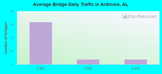
- 16,092Total average daily traffic
- 875Total average daily truck traffic
- National Bridge Inventory (NBI) Registered Bridges for Ardmore
- No street view available for this location
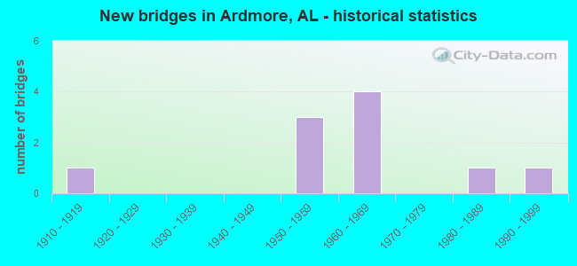
- New bridges - historical statistics
- 11910-1919
- 31950-1959
- 41960-1969
- 11980-1989
- 11990-1999

- Bridge Condition - Superstructure
- 50.0%Very good
- 50.0%Good
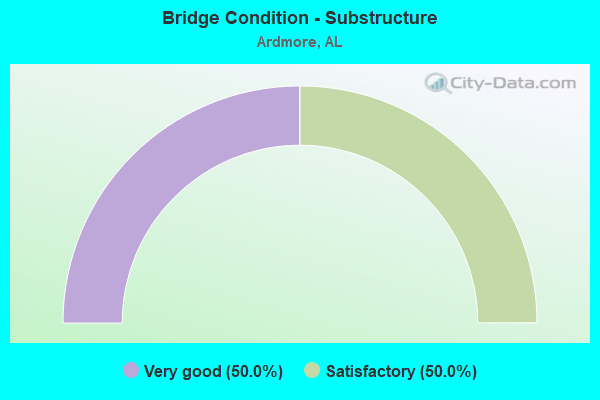
- Bridge Condition - Substructure
- 50.0%Very good
- 50.0%Satisfactory
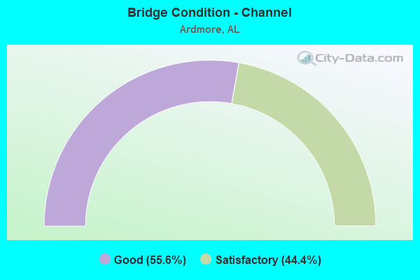
- Bridge Condition - Channel
- 55.6%Good
- 44.4%Satisfactory
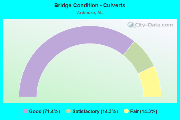
- Bridge Condition - Culverts
- 71.4%Good
- 14.3%Satisfactory
- 14.3%Fair
Find on map >> Show street view
Structure Number: 4952, Location: SEC11 T1S R3W (Lat: 34.962633, Lng: -86.809542), Route carried "on" structure: County highway 117, Year Built: 1954, Status: Posted for load, Structure Length: 2.56m (8.40ft), Average Daily Traffic: 600 (year 2013), Truck Traffic: 1%, Average Future Daily Traffic: 890 (year 2033), Design Load: H 15, Features Intersected: LITTLE LIMESTONE CR, Facility Carried by Structure: PINEDALE RD
Minimum Vertical Clearance: 30+ m (98+ ft), Kilometerpoint: 0.010, Lanes on structure: 2, Owner: County Highway Agency, Approaching Roadway Width: 9.1m (29.9ft), Material/Design: Concrete, Design/Construction: Tee Beam, Number Of Spans In Main Unit: 3, Length of Maximum Span: 8.5m (27.9ft), Curb-To-Curb Width: 6.6m (21.7ft), Out-to-Out Width: 7.5m (24.6ft)
Condition: Deck: Good, Superstructure: Good, Substructure: Satisfactory, Channel: Satisfactory, Operating Rating: 47.9 metric tons, Method Used To Determine Operating Rating: Load Factor (LF), Inventory Rating: 28.8 metric tons, Method Used To Determine Inventory Rating: Load Factor (LF), Structural Evaluation: Equal to present minimum criteria, Deck Geometry: High priority of corrective action, Waterway Adequacy: Better than present minimum criteria, Approach Roadway Alignment: Better than present minimum criteria, Bridge Posting: Required (Relationship of Operating Rating to Maximum Legal Load: 0.1 - 9.9% below), Length Of Structure Improvement: 3.46m (11.35ft), Designated Inspection Frequency: Every 24 months, Other Special Inspection Frequency: Every 12 months, Inspection Date: November 2020, Other Special Inspection Date: November 2021, Bridge Improvement Cost: $569,000, Roadway Improvement Cost: $57,000, Total Project Cost: $626,000 ( Estimate for 2022), Deck Structure Type: Concrete Cast-file-Place
Find on map >> Show street view
Structure Number: 5943, Location: 3.7 M S JCT SR53 & SR251 (Lat: 34.973000, Lng: -86.802600), Route carried "on" structure: State highway 53, Year Built: 1957, Status: Open, Structure Length: 1.34m (4.40ft), Average Daily Traffic: 7,300 (year 2020), Truck Traffic: 9%, Average Future Daily Traffic: 9,489 (year 2033), Design Load: HS 20, Features Intersected: CREEK
Minimum Vertical Clearance: 30+ m (98+ ft), Kilometerpoint: 545.729, Lanes on structure: 2, Base Highway Network: Yes, Owner: State Highway Agency, Approaching Roadway Width: 7.3m (24.0ft), Material/Design: Concrete, Design/Construction: Culvert, Number Of Spans In Main Unit: 4, Length of Maximum Span: 3.0m (9.8ft)
Condition: Channel: Satisfactory, Culverts: Satisfactory, Operating Rating: 67.6 metric tons, Method Used To Determine Operating Rating: Load Factor (LF), Inventory Rating: 40.6 metric tons, Method Used To Determine Inventory Rating: Load Factor (LF), Structural Evaluation: Equal to present minimum criteria, Waterway Adequacy: Equal to present minimum criteria, Approach Roadway Alignment: Better than present minimum criteria, Length Of Structure Improvement: 2.02m (6.63ft), Designated Inspection Frequency: Every 24 months, Inspection Date: August 2020, Bridge Improvement Cost: $629,000, Roadway Improvement Cost: $63,000, Total Project Cost: $692,000 ( Estimate for 2022), Wearing Surface/Protective System: Wearing Surface: Bituminous
Find on map >> Show street view
Structure Number: 7127, Location: SEC9 T1S R3W (Lat: 34.962656, Lng: -86.853261), Route carried "on" structure: County highway 117, Year Built: 1960, Status: Open, Structure Length: 0.62m (2.03ft), Average Daily Traffic: 640 (year 2010), Truck Traffic: 1%, Average Future Daily Traffic: 950 (year 2030), Design Load: H 15, Features Intersected: BRANCH, Facility Carried by Structure: SWEET SPRINGS RD
Minimum Vertical Clearance: 30+ m (98+ ft), Kilometerpoint: 0.010, Lanes on structure: 2, Owner: County Highway Agency, Approaching Roadway Width: 8.5m (27.9ft), Material/Design: Concrete, Design/Construction: Culvert, Number Of Spans In Main Unit: 3, Length of Maximum Span: 1.8m (5.9ft), Curb-To-Curb Width: 9.0m (29.5ft), Out-to-Out Width: 9.4m (30.8ft)
Condition: Channel: Good, Culverts: Good, Operating Rating: 43.3 metric tons, Method Used To Determine Operating Rating: Load Factor (LF), Inventory Rating: 25.9 metric tons, Method Used To Determine Inventory Rating: Load Factor (LF), Structural Evaluation: Equal to present minimum criteria, Deck Geometry: Somewhat better than minimum adequacy, Waterway Adequacy: Better than present minimum criteria, Approach Roadway Alignment: Better than present minimum criteria, Length Of Structure Improvement: 1.23m (4.04ft), Designated Inspection Frequency: Every 24 months, Inspection Date: June 2020, Bridge Improvement Cost: $220,000, Roadway Improvement Cost: $22,000, Total Project Cost: $242,000 ( Estimate for 2022)
Find on map >> Show street view
Structure Number: 7128, Location: SEC9 T1S R3W (Lat: 34.962619, Lng: -86.848494), Route carried "on" structure: County highway 117, Year Built: 1960, Status: Open, Structure Length: 1.62m (5.31ft), Average Daily Traffic: 740 (year 2011), Truck Traffic: 1%, Average Future Daily Traffic: 1,100 (year 2031), Design Load: H 15, Features Intersected: PINEY CR, Facility Carried by Structure: SWEET SPRINGS RD
Minimum Vertical Clearance: 30+ m (98+ ft), Kilometerpoint: 0.010, Lanes on structure: 2, Owner: County Highway Agency, Approaching Roadway Width: 8.5m (27.9ft), Material/Design: Concrete, Design/Construction: Culvert, Number Of Spans In Main Unit: 5, Length of Maximum Span: 3.0m (9.8ft), Curb-To-Curb Width: 8.7m (28.5ft), Out-to-Out Width: 9.2m (30.2ft)
Condition: Channel: Satisfactory, Culverts: Good, Operating Rating: 37.1 metric tons, Method Used To Determine Operating Rating: Load Factor (LF), Inventory Rating: 22.2 metric tons, Method Used To Determine Inventory Rating: Load Factor (LF), Structural Evaluation: Somewhat better than minimum adequacy, Deck Geometry: Somewhat better than minimum adequacy, Waterway Adequacy: Equal to present minimum criteria, Approach Roadway Alignment: Better than present minimum criteria, Length Of Structure Improvement: 2.30m (7.55ft), Designated Inspection Frequency: Every 24 months, Underwater Inspection Frequency: Every 48 months, Inspection Date: Febuary 2021, Underwater Inspection Date: November 2018, Bridge Improvement Cost: $399,000, Roadway Improvement Cost: $40,000, Total Project Cost: $439,000 ( Estimate for 2022)
Find on map >> Show street view
Structure Number: 8433, Location: SEC11 T1S R3W (Lat: 34.962681, Lng: -86.809597), Route carried "on" structure: Bypass County highway 117, Year Built: 1964, Status: Open, Structure Length: 0.79m (2.59ft), Average Daily Traffic: 867 (year 2014), Truck Traffic: 2%, Average Future Daily Traffic: 1,288 (year 2034), Design Load: H 15, Features Intersected: LIMESTONE CREEK FORK, Facility Carried by Structure: PINEDALE RD
Minimum Vertical Clearance: 30+ m (98+ ft), Kilometerpoint: 0.010, Lanes on structure: 2, Owner: County Highway Agency, Approaching Roadway Width: 8.5m (27.9ft), Material/Design: Concrete, Design/Construction: Culvert, Number Of Spans In Main Unit: 3, Length of Maximum Span: 2.7m (8.9ft), Curb-To-Curb Width: 8.7m (28.5ft), Out-to-Out Width: 9.2m (30.2ft)
Condition: Channel: Good, Culverts: Good, Operating Rating: 33.7 metric tons, Method Used To Determine Operating Rating: Load Factor (LF), Inventory Rating: 20.2 metric tons, Method Used To Determine Inventory Rating: Load Factor (LF), Structural Evaluation: Somewhat better than minimum adequacy, Deck Geometry: Somewhat better than minimum adequacy, Waterway Adequacy: Better than present minimum criteria, Approach Roadway Alignment: Better than present minimum criteria, Length Of Structure Improvement: 1.45m (4.76ft), Designated Inspection Frequency: Every 24 months, Inspection Date: May 2020, Bridge Improvement Cost: $251,000, Roadway Improvement Cost: $25,000, Total Project Cost: $276,000 ( Estimate for 2022)
Find on map >> Show street view
Structure Number: 9163, Location: SEC23 T1S R3W (Lat: 34.933408, Lng: -86.806653), Route carried "on" structure: County highway 106, Year Built: 1961, Status: Open, Structure Length: 2.41m (7.91ft), Average Daily Traffic: 600 (year 2011), Truck Traffic: 1%, Average Future Daily Traffic: 890 (year 2031), Design Load: H 15, Features Intersected: LITTLE LIMESTONE CR, Facility Carried by Structure: BETHEL ROAD
Minimum Vertical Clearance: 30+ m (98+ ft), Kilometerpoint: 0.010, Lanes on structure: 2, Owner: County Highway Agency, Approaching Roadway Width: 8.5m (27.9ft), Material/Design: Concrete, Design/Construction: Culvert, Number Of Spans In Main Unit: 5, Length of Maximum Span: 4.6m (15.1ft), Curb-To-Curb Width: 9.0m (29.5ft), Out-to-Out Width: 9.4m (30.8ft)
Condition: Channel: Good, Culverts: Good, Operating Rating: 42.3 metric tons, Method Used To Determine Operating Rating: Load Factor (LF), Inventory Rating: 25.4 metric tons, Method Used To Determine Inventory Rating: Load Factor (LF), Structural Evaluation: Equal to present minimum criteria, Deck Geometry: Somewhat better than minimum adequacy, Waterway Adequacy: Equal to present minimum criteria, Approach Roadway Alignment: Better than present minimum criteria, Length Of Structure Improvement: 3.27m (10.73ft), Designated Inspection Frequency: Every 24 months, Inspection Date: Febuary 2021, Bridge Improvement Cost: $585,000, Roadway Improvement Cost: $59,000, Total Project Cost: $644,000 ( Estimate for 2022)
Find on map >> Show street view
Structure Number: 13677, Location: SEC2 T1S R3W (Lat: 34.977181, Lng: -86.809456), Route carried "on" structure: County highway 118, Year Built: 1985, Status: Open, Structure Length: 1.79m (5.87ft), Average Daily Traffic: 550 (year 2011), Truck Traffic: 1%, Average Future Daily Traffic: 820 (year 2031), Design Load: HS 20, Features Intersected: LITTLE LIMESTONE CREEK, Facility Carried by Structure: CEDAR HILL RD
Minimum Vertical Clearance: 30+ m (98+ ft), Kilometerpoint: 0.010, Lanes on structure: 2, Owner: County Highway Agency, Approaching Roadway Width: 8.5m (27.9ft), Skew: 3 degrees, Material/Design: Concrete, Design/Construction: Culvert, Number Of Spans In Main Unit: 4, Length of Maximum Span: 4.5m (14.8ft), Curb-To-Curb Width: 12.4m (40.7ft), Out-to-Out Width: 12.9m (42.3ft)
Condition: Channel: Good, Culverts: Good, Operating Rating: 77.9 metric tons, Method Used To Determine Operating Rating: Load Factor (LF), Inventory Rating: 46.7 metric tons, Method Used To Determine Inventory Rating: Load Factor (LF), Structural Evaluation: Better than present minimum criteria, Deck Geometry: Superior to present desirable criteria, Waterway Adequacy: Equal to present minimum criteria, Approach Roadway Alignment: Equal to present minimum criteria, Length Of Structure Improvement: 2.50m (8.20ft), Designated Inspection Frequency: Every 24 months, Inspection Date: Febuary 2021, Bridge Improvement Cost: $634,000, Roadway Improvement Cost: $63,000, Total Project Cost: $697,000 ( Estimate for 2022)
Find on map >> Show street view
Structure Number: 15637, Location: SEC21 T1S R3W (Lat: 34.933417, Lng: -86.842639), Route carried "on" structure: County highway 106, Year Built: 1991, Status: Open, Structure Length: 4.15m (13.62ft), Average Daily Traffic: 520 (year 2010), Truck Traffic: 1%, Average Future Daily Traffic: 770 (year 2030), Design Load: HS 20, Features Intersected: PINEY CREEK, Facility Carried by Structure: BETHEL ROAD
Minimum Vertical Clearance: 30+ m (98+ ft), Kilometerpoint: 0.010, Lanes on structure: 2, Owner: County Highway Agency, Approaching Roadway Width: 7.3m (24.0ft), Material/Design: Concrete, Design/Construction: Channel Beam, Number Of Spans In Main Unit: 4, Length of Maximum Span: 10.4m (34.1ft), Curb-To-Curb Width: 8.5m (27.9ft), Out-to-Out Width: 8.5m (27.9ft)
Condition: Deck: Good, Superstructure: Very good, Substructure: Very good, Channel: Good, Operating Rating: 60.8 metric tons, Method Used To Determine Operating Rating: Load Factor (LF), Inventory Rating: 36.4 metric tons, Method Used To Determine Inventory Rating: Load Factor (LF), Structural Evaluation: Equal to present desirable criteria, Deck Geometry: Somewhat better than minimum adequacy, Waterway Adequacy: Equal to present desirable criteria, Approach Roadway Alignment: Better than present minimum criteria, Length Of Structure Improvement: 5.12m (16.80ft), Designated Inspection Frequency: Every 24 months, Inspection Date: September 2020, Bridge Improvement Cost: $948,000, Roadway Improvement Cost: $95,000, Total Project Cost: $1,043,000 ( Estimate for 2022), Deck Structure Type: Concrete Precast Panels
Find on map >> Show street view
Structure Number: 21639, Location: _ (Lat: 34.925511, Lng: -86.846575), Route carried "on" structure: County highway , Year Built: 1953, Status: Open, Structure Length: 1.01m (3.31ft), Average Daily Traffic: 185 (year 2020), Truck Traffic: 2%, Average Future Daily Traffic: 541 (year 2042), Features Intersected: _HAUSKIN BRANCH, Facility Carried by Structure: _SAND SPRINGS RD.
Minimum Vertical Clearance: 30+ m (98+ ft), Kilometerpoint: 0.000, Lanes on structure: 2, Owner: County Highway Agency, Approaching Roadway Width: 5.8m (19.0ft), Material/Design: Concrete, Design/Construction: Culvert, Number Of Spans In Main Unit: 3, Length of Maximum Span: 3.1m (10.2ft), Curb-To-Curb Width: 5.8m (19.0ft), Out-to-Out Width: 8.7m (28.5ft)
Condition: Channel: Satisfactory, Culverts: Fair, Operating Rating: 43.5 metric tons, Method Used To Determine Operating Rating: Field evaluation and documented engineering judgment, Inventory Rating: 32.7 metric tons, Method Used To Determine Inventory Rating: Field evaluation and documented engineering judgment, Structural Evaluation: Somewhat better than minimum adequacy, Deck Geometry: High priority of corrective action, Waterway Adequacy: Better than present minimum criteria, Approach Roadway Alignment: Better than present minimum criteria, Length Of Structure Improvement: 1.69m (5.54ft), Designated Inspection Frequency: Every 24 months, Inspection Date: April 2021, Bridge Improvement Cost: $273,000, Roadway Improvement Cost: $27,000, Total Project Cost: $300,000 ( Estimate for 2022), Deck Structure Type: Concrete Cast-file-Place, Wearing Surface/Protective System: Wearing Surface: Bituminous
Find on map >> Show street view
Structure Number: 12453, Location: 2 MI E JCT I 65 & SR 53 (Lat: 34.983333, Lng: -86.851667), Route carried "under" structure: State highway 53, Year Built: 1913, Structure Length: 0. m, Average Daily Traffic: 4,090 (year 2013), Truck Traffic: 4%, Features Intersected: SR 53, Facility Carried by Structure: CSX RAILROAD
Minimum Vertical Clearance: 3.54m (11.61ft), Kilometerpoint: 552.359, Lanes under structure: 1, Material/Design: Concrete, Design/Construction: Slab, Length of Maximum Span: 6.7m (22.0ft)