Bridge Statistics for Anna, Ohio (OH)
Condition, Traffic, Stress, Structural Evaluation, Project Costs
- National Bridge Inventory (NBI) Statistics
- 21Number of bridges
- 154ft / 46.8mTotal length
- 168,904Total average daily traffic
- 40,277Total average daily truck traffic
- National Bridge Inventory (NBI) Registered Bridges for Anna
- No street view available for this location
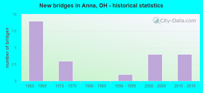
- New bridges - historical statistics
- 91960-1969
- 31970-1979
- 11990-1999
- 42000-2009
- 42010-2019


- Bridge Condition - Deck
- 18.8%Excellent
- 31.3%Very good
- 25.0%Good
- 25.0%Satisfactory

- Bridge Condition - Superstructure
- 18.8%Excellent
- 43.8%Very good
- 18.8%Good
- 18.8%Satisfactory

- Bridge Condition - Substructure
- 18.8%Excellent
- 37.5%Very good
- 37.5%Good
- 6.3%Fair

- Bridge Condition - Channel
- 23.1%Excellent
- 30.8%Very good
- 30.8%Good
- 15.4%Satisfactory
Find on map >> Show street view
Structure Number: 750013, Location: .2 M.N. OF FT.LOR/SWAN (Lat: 40.364100, Lng: -84.226181), Route carried "on" structure: State highway 29, Year Built: 2003, Status: Open, Structure Length: 0.68m (2.23ft), Average Daily Traffic: 5,779 (year 2015), Truck Traffic: 10%, Average Future Daily Traffic: 8,021 (year 2035), Design Load: HS 25 or greater, Features Intersected: TURTLE CREEK
Minimum Vertical Clearance: 30+ m (98+ ft), Kilometerpoint: 16.625, Lanes on structure: 2, Owner: State Highway Agency, Approaching Roadway Width: 8.5m (27.9ft), Material/Design: Concrete, Design/Construction: Culvert, Number Of Spans In Main Unit: 1, Length of Maximum Span: 6.2m (20.3ft)
Condition: Channel: Satisfactory, Culverts: Excellent, Operating Rating: 42.1 metric tons, Method Used To Determine Operating Rating: Load Factor (LF) rating reported by rating factor (RF) method using MS18 loading, Inventory Rating: 32.4 metric tons, Method Used To Determine Inventory Rating: Load Factor (LF) rating reported by rating factor (RF) method using MS18 loading, Structural Evaluation: Equal to present desirable criteria, Waterway Adequacy: Equal to present desirable criteria, Approach Roadway Alignment: Equal to present desirable criteria, Designated Inspection Frequency: Every 24 months, Inspection Date: July 2021
Find on map >> Show street view
Structure Number: 7502281, Location: 2.4MI. S. OF JCT. SR-119 (Lat: 40.360350, Lng: -84.160669), Route carried "on" structure: County highway C0027, Year Built: 1962, Status: Open, Structure Length: 7.01m (23.00ft), Average Daily Traffic: 586 (year 2015), Truck Traffic: 8%, Average Future Daily Traffic: 50,083 (year 2035), Design Load: H 15, Features Intersected: IR 75, Facility Carried by Structure: CR-27
Minimum Vertical Clearance: 30+ m (98+ ft), Kilometerpoint: 16.882, Lanes on structure: 2, Lanes under structure: 4, Owner: State Highway Agency, Approaching Roadway Width: 8.5m (27.9ft), Material/Design: Steel continuous, Design/Construction: Stringer/Multi-beam, Number Of Spans In Main Unit: 4, Length of Maximum Span: 21.3m (69.9ft), Curb or Sidewalk Widths: Left: 0.6m (2.0ft), Right: 0.6m (2.0ft), Curb-To-Curb Width: 7.3m (24.0ft), Out-to-Out Width: 9.2m (30.2ft)
Condition: Deck: Good, Superstructure: Good, Substructure: Good, Operating Rating: 38.9 metric tons, Method Used To Determine Operating Rating: Load Factor (LF) rating reported by rating factor (RF) method using MS18 loading, Inventory Rating: 22.7 metric tons, Method Used To Determine Inventory Rating: Load Factor (LF) rating reported by rating factor (RF) method using MS18 loading, Structural Evaluation: Equal to present minimum criteria, Deck Geometry: Meets minimum limits, Underclear: Somewhat better than minimum adequacy, Approach Roadway Alignment: Better than present minimum criteria, Designated Inspection Frequency: Every 24 months, Inspection Date: August 2021, Deck Structure Type: Concrete Cast-file-Place, Wearing Surface/Protective System: Wearing Surface: Integral Concrete
Find on map >> Show street view
Structure Number: 7502346, Location: 1MI. S OF JCT SR-119 (Lat: 40.380589, Lng: -84.160850), Route carried "on" structure: County highway C0057, Year Built: 1962, Status: Posted for load, Structure Length: 7.01m (23.00ft), Average Daily Traffic: 634 (year 2015), Truck Traffic: 8%, Average Future Daily Traffic: 50,083 (year 2035), Design Load: H 10, Features Intersected: IR 75, Facility Carried by Structure: TR-57
Minimum Vertical Clearance: 30+ m (98+ ft), Kilometerpoint: 6.920, Lanes on structure: 2, Lanes under structure: 4, Owner: State Highway Agency, Approaching Roadway Width: 8.5m (27.9ft), Material/Design: Steel continuous, Design/Construction: Stringer/Multi-beam, Number Of Spans In Main Unit: 4, Length of Maximum Span: 21.3m (69.9ft), Curb or Sidewalk Widths: Left: 0.6m (2.0ft), Right: 0.6m (2.0ft), Curb-To-Curb Width: 7.3m (24.0ft), Out-to-Out Width: 9.2m (30.2ft)
Condition: Deck: Good, Superstructure: Good, Substructure: Good, Operating Rating: 32.4 metric tons, Method Used To Determine Operating Rating: Load Factor (LF) rating reported by rating factor (RF) method using MS18 loading, Inventory Rating: 19.4 metric tons, Method Used To Determine Inventory Rating: Load Factor (LF) rating reported by rating factor (RF) method using MS18 loading, Structural Evaluation: Somewhat better than minimum adequacy, Deck Geometry: Meets minimum limits, Underclear: Somewhat better than minimum adequacy, Approach Roadway Alignment: Better than present minimum criteria, Bridge Posting: Required (Relationship of Operating Rating to Maximum Legal Load: 10.0 - 19.9% below), Designated Inspection Frequency: Every 12 months, Inspection Date: August 2021, Deck Structure Type: Concrete Cast-file-Place, Wearing Surface/Protective System: Wearing Surface: Integral Concrete
Find on map >> Show street view
Structure Number: 7502435, Location: 1.04MI.N.OF JCT. SR-119 (Lat: 40.409711, Lng: -84.166369), Route carried "on" structure: County highway C0043, Year Built: 1962, Status: Open, Structure Length: 7.25m (23.79ft), Average Daily Traffic: 284 (year 2015), Truck Traffic: 7%, Average Future Daily Traffic: 50,426 (year 2035), Design Load: H 15, Features Intersected: IR 75, Facility Carried by Structure: CR-43
Minimum Vertical Clearance: 30+ m (98+ ft), Kilometerpoint: 14.532, Lanes on structure: 2, Lanes under structure: 4, Owner: State Highway Agency, Approaching Roadway Width: 8.5m (27.9ft), Skew: 1 degrees, Material/Design: Steel continuous, Design/Construction: Stringer/Multi-beam, Number Of Spans In Main Unit: 4, Length of Maximum Span: 22.3m (73.2ft), Curb or Sidewalk Widths: Left: 0.6m (2.0ft), Right: 0.6m (2.0ft), Curb-To-Curb Width: 7.3m (24.0ft), Out-to-Out Width: 9.2m (30.2ft)
Condition: Deck: Good, Superstructure: Very good, Substructure: Good, Operating Rating: 35.6 metric tons, Method Used To Determine Operating Rating: Load and Resistance Factor Rating (LRFR) rating reported by rating factor(RF) method using HL-93 loadings, Inventory Rating: 29.2 metric tons, Method Used To Determine Inventory Rating: Load and Resistance Factor Rating (LRFR) rating reported by rating factor(RF) method using HL-93 loadings, Structural Evaluation: Better than present minimum criteria, Deck Geometry: Somewhat better than minimum adequacy, Underclear: Somewhat better than minimum adequacy, Approach Roadway Alignment: Better than present minimum criteria, Designated Inspection Frequency: Every 24 months, Inspection Date: July 2021, Deck Structure Type: Concrete Cast-file-Place, Wearing Surface/Protective System: Wearing Surface: Latex Concrete
Find on map >> Show street view
Structure Number: 750285, Location: JCT. IR-75 (Lat: 40.395169, Lng: -84.161239), Route carried "on" structure: State highway 119, Year Built: 1962, Year Reconstructed: 1997, Status: Open, Structure Length: 7.01m (23.00ft), Average Daily Traffic: 5,796 (year 2015), Truck Traffic: 9%, Average Future Daily Traffic: 8,045 (year 2035), Design Load: HS 20+Mod, Features Intersected: IR 75
Minimum Vertical Clearance: 30+ m (98+ ft), Kilometerpoint: 15.080, Lanes on structure: 2, Lanes under structure: 4, Owner: State Highway Agency, Approaching Roadway Width: 14.6m (47.9ft), Material/Design: Steel continuous, Design/Construction: Stringer/Multi-beam, Number Of Spans In Main Unit: 4, Length of Maximum Span: 21.3m (69.9ft), Curb-To-Curb Width: 14.6m (47.9ft), Out-to-Out Width: 15.6m (51.2ft)
Condition: Deck: Satisfactory, Superstructure: Very good, Substructure: Very good, Operating Rating: 29.2 metric tons, Method Used To Determine Operating Rating: Load and Resistance Factor Rating (LRFR) rating reported by rating factor(RF) method using HL-93 loadings, Inventory Rating: 22.7 metric tons, Method Used To Determine Inventory Rating: Load and Resistance Factor Rating (LRFR) rating reported by rating factor(RF) method using HL-93 loadings, Structural Evaluation: Somewhat better than minimum adequacy, Deck Geometry: Superior to present desirable criteria, Underclear: Somewhat better than minimum adequacy, Approach Roadway Alignment: Better than present minimum criteria, Designated Inspection Frequency: Every 12 months, Inspection Date: July 2021, Deck Structure Type: Concrete Cast-file-Place, Wearing Surface/Protective System: Wearing Surface: Monolithic Concrete, Deck Protection: Epoxy Coated Reinforcing
Find on map >> Show street view
Structure Number: 7530001, Location: 1.5 miles west of 25A (Lat: 40.409369, Lng: -84.197231), Route carried "on" structure: County highway T0043, Year Built: 2014, Status: Open, Structure Length: 1.28m (4.20ft), Average Daily Traffic: 288 (year 2020), Truck Traffic: 7%, Average Future Daily Traffic: 450 (year 2040), Design Load: HL 93, Features Intersected: Clay Creek, Facility Carried by Structure: Wells Rd
Minimum Vertical Clearance: 30+ m (98+ ft), Kilometerpoint: 12.054, Lanes on structure: 2, Owner: County Highway Agency, Approaching Roadway Width: 4.9m (16.1ft), Material/Design: Prestressed concrete, Design/Construction: Box Beam or Girders - Multiple, Number Of Spans In Main Unit: 1, Length of Maximum Span: 12.5m (41.0ft), Curb-To-Curb Width: 8.5m (27.9ft), Out-to-Out Width: 8.5m (27.9ft)
Condition: Deck: Excellent, Superstructure: Excellent, Substructure: Excellent, Channel: Excellent, Operating Rating: 77.8 metric tons, Method Used To Determine Operating Rating: Load and Resistance Factor Rating (LRFR) rating reported by rating factor(RF) method using HL-93 loadings, Inventory Rating: 58.3 metric tons, Method Used To Determine Inventory Rating: Load and Resistance Factor Rating (LRFR) rating reported by rating factor(RF) method using HL-93 loadings, Structural Evaluation: Superior to present desirable criteria, Deck Geometry: Equal to present minimum criteria, Waterway Adequacy: Better than present minimum criteria, Approach Roadway Alignment: Better than present minimum criteria, Length Of Structure Improvement: 1.28m (4.20ft), Designated Inspection Frequency: Every 24 months, Inspection Date: June 2021, Deck Structure Type: Other, Wearing Surface/Protective System: Wearing Surface: Bituminous, Membrane: Preformed Fabric
Find on map >> Show street view
Structure Number: 7530331, Location: .6 M N FT. LORMAIE SWANDE (Lat: 40.369189, Lng: -84.132481), Route carried "on" structure: County highway C0017, Year Built: 1972, Status: Open, Structure Length: 1.77m (5.81ft), Average Daily Traffic: 564 (year 2020), Truck Traffic: 8%, Average Future Daily Traffic: 942 (year 2040), Design Load: HS 20, Features Intersected: PLUM CREEK, Facility Carried by Structure: SIDNEY FREYBURG
Minimum Vertical Clearance: 30+ m (98+ ft), Kilometerpoint: 5.987, Lanes on structure: 2, Owner: County Highway Agency, Approaching Roadway Width: 8.5m (27.9ft), Material/Design: Concrete continuous, Design/Construction: Slab, Number Of Spans In Main Unit: 3, Length of Maximum Span: 6.4m (21.0ft), Curb-To-Curb Width: 7.3m (24.0ft), Out-to-Out Width: 7.3m (24.0ft)
Condition: Deck: Satisfactory, Superstructure: Satisfactory, Substructure: Good, Channel: Good, Operating Rating: 48.6 metric tons, Method Used To Determine Operating Rating: Load Factor (LF) rating reported by rating factor (RF) method using MS18 loading, Inventory Rating: 29.2 metric tons, Method Used To Determine Inventory Rating: Load Factor (LF) rating reported by rating factor (RF) method using MS18 loading, Structural Evaluation: Equal to present minimum criteria, Deck Geometry: Meets minimum limits, Waterway Adequacy: Equal to present desirable criteria, Approach Roadway Alignment: Equal to present desirable criteria, Designated Inspection Frequency: Every 12 months, Inspection Date: March 2021, Deck Structure Type: Concrete Cast-file-Place, Wearing Surface/Protective System: Wearing Surface: Bituminous
Find on map >> Show street view
Structure Number: 7530609, Location: 0.4 M.E. of SR 29 (Lat: 40.359589, Lng: -84.229111), Route carried "on" structure: County highway C0027, Year Built: 2016, Status: Open, Structure Length: 1.00m (3.28ft), Average Daily Traffic: 1,045 (year 2020), Truck Traffic: 11%, Average Future Daily Traffic: 3,054 (year 2040), Design Load: HL 93, Features Intersected: Turtle Creek, Facility Carried by Structure: Ft. Loramie Swandr
Minimum Vertical Clearance: 30+ m (98+ ft), Kilometerpoint: 10.638, Lanes on structure: 2, Owner: County Highway Agency, Approaching Roadway Width: 7.9m (25.9ft), Skew: 1 degrees, Material/Design: Prestressed concrete, Design/Construction: Box Beam or Girders - Multiple, Number Of Spans In Main Unit: 1, Length of Maximum Span: 9.7m (31.8ft), Curb-To-Curb Width: 8.5m (27.9ft), Out-to-Out Width: 8.5m (27.9ft)
Condition: Deck: Excellent, Superstructure: Excellent, Substructure: Excellent, Channel: Excellent, Operating Rating: 74.5 metric tons, Method Used To Determine Operating Rating: Load and Resistance Factor Rating (LRFR) rating reported by rating factor(RF) method using HL-93 loadings, Inventory Rating: 58.3 metric tons, Method Used To Determine Inventory Rating: Load and Resistance Factor Rating (LRFR) rating reported by rating factor(RF) method using HL-93 loadings, Structural Evaluation: Superior to present desirable criteria, Deck Geometry: Somewhat better than minimum adequacy, Waterway Adequacy: Better than present minimum criteria, Approach Roadway Alignment: Equal to present desirable criteria, Designated Inspection Frequency: Every 24 months, Inspection Date: December 2021, Deck Structure Type: Concrete Cast-file-Place, Wearing Surface/Protective System: Wearing Surface: Bituminous, Membrane: Preformed Fabric
Find on map >> Show street view
Structure Number: 7536232, Location: 1.0 Mile east of 25a (Lat: 40.360450, Lng: -84.151869), Route carried "on" structure: County highway C0027, Year Built: 2017, Status: Open, Structure Length: 2.82m (9.25ft), Average Daily Traffic: 569 (year 2020), Truck Traffic: 10%, Average Future Daily Traffic: 1,200 (year 2040), Design Load: HL 93, Features Intersected: Plum Creek, Facility Carried by Structure: Ft. Loramie Swande
Minimum Vertical Clearance: 30+ m (98+ ft), Kilometerpoint: 17.204, Lanes on structure: 2, Owner: County Highway Agency, Approaching Roadway Width: 6.1m (20.0ft), Skew: 3 degrees, Material/Design: Prestressed concrete, Design/Construction: Box Beam or Girders - Multiple, Number Of Spans In Main Unit: 3, Length of Maximum Span: 9.1m (29.9ft), Curb-To-Curb Width: 8.5m (27.9ft), Out-to-Out Width: 8.5m (27.9ft)
Condition: Deck: Excellent, Superstructure: Excellent, Substructure: Excellent, Channel: Excellent, Operating Rating: 77.8 metric tons, Method Used To Determine Operating Rating: Load and Resistance Factor Rating (LRFR) rating reported by rating factor(RF) method using HL-93 loadings, Inventory Rating: 61.6 metric tons, Method Used To Determine Inventory Rating: Load and Resistance Factor Rating (LRFR) rating reported by rating factor(RF) method using HL-93 loadings, Structural Evaluation: Superior to present desirable criteria, Deck Geometry: Somewhat better than minimum adequacy, Waterway Adequacy: Better than present minimum criteria, Approach Roadway Alignment: Better than present minimum criteria, Length Of Structure Improvement: 3.05m (10.01ft), Designated Inspection Frequency: Every 24 months, Inspection Date: April 2021, Deck Structure Type: Concrete Cast-file-Place, Wearing Surface/Protective System: Wearing Surface: Bituminous, Membrane: Preformed Fabric
Find on map >> Show street view
Structure Number: 7537727, Location: .36 M. N. MERANDA (Lat: 40.385869, Lng: -84.121089), Route carried "on" structure: County highway T0031, Year Built: 1976, Status: Open, Structure Length: 1.52m (4.99ft), Average Daily Traffic: 351 (year 2015), Truck Traffic: 7%, Average Future Daily Traffic: 487 (year 2035), Design Load: HS 20, Features Intersected: PLUM CREEK, Facility Carried by Structure: LOCHARD ROAD
Minimum Vertical Clearance: 30+ m (98+ ft), Kilometerpoint: 8.031, Lanes on structure: 2, Owner: County Highway Agency, Approaching Roadway Width: 9.1m (29.9ft), Skew: 2 degrees, Material/Design: Concrete continuous, Design/Construction: Slab, Number Of Spans In Main Unit: 3, Length of Maximum Span: 5.5m (18.0ft), Curb-To-Curb Width: 7.3m (24.0ft), Out-to-Out Width: 7.3m (24.0ft)
Condition: Deck: Good, Superstructure: Good, Substructure: Good, Channel: Good, Operating Rating: 55.1 metric tons, Method Used To Determine Operating Rating: Load Factor (LF) rating reported by rating factor (RF) method using MS18 loading, Inventory Rating: 32.4 metric tons, Method Used To Determine Inventory Rating: Load Factor (LF) rating reported by rating factor (RF) method using MS18 loading, Structural Evaluation: Better than present minimum criteria, Deck Geometry: Somewhat better than minimum adequacy, Waterway Adequacy: Superior to present desirable criteria, Approach Roadway Alignment: Superior to present desirable criteria, Designated Inspection Frequency: Every 24 months, Inspection Date: April 2021, Deck Structure Type: Concrete Cast-file-Place, Wearing Surface/Protective System: Wearing Surface: Bituminous
Find on map >> Show street view
Structure Number: 7540582, Location: 170' E. OF WENGER ROAD (Lat: 40.409539, Lng: -84.201431), Route carried "on" structure: County highway T0043, Year Built: 2004, Status: Open, Structure Length: 1.34m (4.40ft), Average Daily Traffic: 288 (year 2020), Truck Traffic: 7%, Average Future Daily Traffic: 450 (year 2040), Design Load: HS 20+Mod, Features Intersected: CLAY CREEK, Facility Carried by Structure: WELLS ROAD
Minimum Vertical Clearance: 30+ m (98+ ft), Kilometerpoint: 11.700, Lanes on structure: 2, Owner: County Highway Agency, Approaching Roadway Width: 6.4m (21.0ft), Skew: 2 degrees, Material/Design: Prestressed concrete, Design/Construction: Box Beam or Girders - Multiple, Number Of Spans In Main Unit: 1, Length of Maximum Span: 13.4m (44.0ft), Curb-To-Curb Width: 8.5m (27.9ft), Out-to-Out Width: 8.5m (27.9ft)
Condition: Deck: Very good, Superstructure: Very good, Substructure: Very good, Channel: Very good, Operating Rating: 51.8 metric tons, Method Used To Determine Operating Rating: Load and Resistance Factor Rating (LRFR) rating reported by rating factor(RF) method using HL-93 loadings, Inventory Rating: 38.9 metric tons, Method Used To Determine Inventory Rating: Load and Resistance Factor Rating (LRFR) rating reported by rating factor(RF) method using HL-93 loadings, Structural Evaluation: Equal to present desirable criteria, Deck Geometry: Equal to present minimum criteria, Waterway Adequacy: Superior to present desirable criteria, Approach Roadway Alignment: Equal to present desirable criteria, Designated Inspection Frequency: Every 24 months, Inspection Date: June 2021, Deck Structure Type: Concrete Cast-file-Place, Wearing Surface/Protective System: Wearing Surface: Bituminous, Membrane: Built-up, Deck Protection: Epoxy Coated Reinforcing
Find on map >> Show street view
Structure Number: 7540884, Location: 0.67 M. E. OF LOCHARD RD (Lat: 40.410200, Lng: -84.108311), Route carried "on" structure: County highway C0043, Year Built: 2004, Status: Open, Structure Length: 1.16m (3.81ft), Average Daily Traffic: 288 (year 2020), Truck Traffic: 7%, Average Future Daily Traffic: 394 (year 2040), Design Load: HS 20+Mod, Features Intersected: PLUM CREEK, Facility Carried by Structure: WELLS
Minimum Vertical Clearance: 30+ m (98+ ft), Kilometerpoint: 19.602, Lanes on structure: 2, Owner: County Highway Agency, Approaching Roadway Width: 6.1m (20.0ft), Material/Design: Prestressed concrete, Design/Construction: Box Beam or Girders - Multiple, Number Of Spans In Main Unit: 1, Length of Maximum Span: 11.3m (37.1ft), Curb-To-Curb Width: 8.5m (27.9ft), Out-to-Out Width: 8.5m (27.9ft)
Condition: Deck: Very good, Superstructure: Very good, Substructure: Very good, Channel: Very good, Operating Rating: 48.6 metric tons, Method Used To Determine Operating Rating: Load and Resistance Factor Rating (LRFR) rating reported by rating factor(RF) method using HL-93 loadings, Inventory Rating: 38.9 metric tons, Method Used To Determine Inventory Rating: Load and Resistance Factor Rating (LRFR) rating reported by rating factor(RF) method using HL-93 loadings, Structural Evaluation: Equal to present desirable criteria, Deck Geometry: Equal to present minimum criteria, Waterway Adequacy: Equal to present desirable criteria, Approach Roadway Alignment: Equal to present desirable criteria, Designated Inspection Frequency: Every 24 months, Inspection Date: June 2021, Deck Structure Type: Concrete Cast-file-Place, Wearing Surface/Protective System: Wearing Surface: Bituminous, Membrane: Built-up, Deck Protection: Epoxy Coated Reinforcing
Find on map >> Show street view
Structure Number: 7543603, Location: 0.07 M. N. WELLS ROAD (Lat: 40.410400, Lng: -84.201989), Route carried "on" structure: County highway C0050, Year Built: 2004, Status: Open, Structure Length: 1.55m (5.09ft), Average Daily Traffic: 1,189 (year 2020), Truck Traffic: 8%, Average Future Daily Traffic: 1,351 (year 2040), Design Load: HS 20+Mod, Features Intersected: CLAY CREEK, Facility Carried by Structure: WENGER ROAD
Minimum Vertical Clearance: 30+ m (98+ ft), Kilometerpoint: 6.840, Lanes on structure: 2, Owner: County Highway Agency, Approaching Roadway Width: 6.4m (21.0ft), Skew: 3 degrees, Material/Design: Prestressed concrete, Design/Construction: Box Beam or Girders - Multiple, Number Of Spans In Main Unit: 1, Length of Maximum Span: 15.2m (49.9ft), Curb-To-Curb Width: 8.5m (27.9ft), Out-to-Out Width: 8.5m (27.9ft)
Condition: Deck: Very good, Superstructure: Very good, Substructure: Very good, Channel: Very good, Operating Rating: 55.1 metric tons, Method Used To Determine Operating Rating: Load and Resistance Factor Rating (LRFR) rating reported by rating factor(RF) method using HL-93 loadings, Inventory Rating: 42.1 metric tons, Method Used To Determine Inventory Rating: Load and Resistance Factor Rating (LRFR) rating reported by rating factor(RF) method using HL-93 loadings, Structural Evaluation: Equal to present desirable criteria, Deck Geometry: Somewhat better than minimum adequacy, Waterway Adequacy: Equal to present desirable criteria, Approach Roadway Alignment: Equal to present desirable criteria, Designated Inspection Frequency: Every 24 months, Inspection Date: June 2021, Deck Structure Type: Concrete Cast-file-Place, Wearing Surface/Protective System: Wearing Surface: Bituminous, Membrane: Built-up, Deck Protection: Epoxy Coated Reinforcing
Find on map >> Show street view
Structure Number: 7545088, Location: .05 M.W. LOCHARD (Lat: 40.380781, Lng: -84.122031), Route carried "on" structure: County highway T0057, Year Built: 1976, Status: Open, Structure Length: 1.52m (4.99ft), Average Daily Traffic: 1,334 (year 2020), Truck Traffic: 8%, Average Future Daily Traffic: 880 (year 2040), Design Load: HS 20+Mod, Features Intersected: PLUM CREEK, Facility Carried by Structure: MERANDA ROAD
Minimum Vertical Clearance: 30+ m (98+ ft), Kilometerpoint: 10.042, Lanes on structure: 2, Owner: County Highway Agency, Approaching Roadway Width: 7.9m (25.9ft), Skew: 3 degrees, Material/Design: Concrete continuous, Design/Construction: Slab, Number Of Spans In Main Unit: 3, Length of Maximum Span: 5.5m (18.0ft), Curb-To-Curb Width: 7.3m (24.0ft), Out-to-Out Width: 7.3m (24.0ft)
Condition: Deck: Satisfactory, Superstructure: Satisfactory, Substructure: Fair, Channel: Good, Operating Rating: 58.3 metric tons, Method Used To Determine Operating Rating: Load Factor (LF) rating reported by rating factor (RF) method using MS18 loading, Inventory Rating: 35.6 metric tons, Method Used To Determine Inventory Rating: Load Factor (LF) rating reported by rating factor (RF) method using MS18 loading, Structural Evaluation: Somewhat better than minimum adequacy, Deck Geometry: Meets minimum limits, Waterway Adequacy: Superior to present desirable criteria, Approach Roadway Alignment: Superior to present desirable criteria, Designated Inspection Frequency: Every 12 months, Inspection Date: September 2021, Deck Structure Type: Concrete Cast-file-Place, Wearing Surface/Protective System: Wearing Surface: Bituminous
Find on map >> Show street view
Structure Number: 7555911, Location: .16 M.S. FT.LORAMIE SWAND (Lat: 40.357300, Lng: -84.233019), Route carried "on" structure: County highway T0173, Year Built: 1967, Status: Open, Structure Length: 0.94m (3.08ft), Average Daily Traffic: 324 (year 2015), Truck Traffic: 7%, Average Future Daily Traffic: 450 (year 2035), Design Load: HS 20, Features Intersected: TURTLE CREEK DITCH, Facility Carried by Structure: MCCLURE ROAD
Minimum Vertical Clearance: 30+ m (98+ ft), Kilometerpoint: 1.368, Lanes on structure: 2, Owner: County Highway Agency, Approaching Roadway Width: 7.9m (25.9ft), Material/Design: Steel, Design/Construction: Stringer/Multi-beam, Number Of Spans In Main Unit: 1, Length of Maximum Span: 9.1m (29.9ft), Curb-To-Curb Width: 7.9m (25.9ft), Out-to-Out Width: 7.9m (25.9ft)
Condition: Deck: Satisfactory, Superstructure: Satisfactory, Substructure: Good, Channel: Satisfactory, Operating Rating: 61.6 metric tons, Method Used To Determine Operating Rating: Load Factor (LF) rating reported by rating factor (RF) method using MS18 loading, Inventory Rating: 35.6 metric tons, Method Used To Determine Inventory Rating: Load Factor (LF) rating reported by rating factor (RF) method using MS18 loading, Structural Evaluation: Equal to present minimum criteria, Deck Geometry: Somewhat better than minimum adequacy, Waterway Adequacy: Superior to present desirable criteria, Approach Roadway Alignment: Superior to present desirable criteria, Designated Inspection Frequency: Every 12 months, Inspection Date: December 2021, Deck Structure Type: Concrete Cast-file-Place, Wearing Surface/Protective System: Wearing Surface: Bituminous
Find on map >> Show street view
Structure Number: 7556543, Location: 0.44 M N OF FT LOR SWANDE (Lat: 40.366631, Lng: -84.169681), Route carried "on" structure: County highway C025A, Year Built: 2010, Status: Open, Structure Length: 1.34m (4.40ft), Average Daily Traffic: 4,853 (year 2020), Truck Traffic: 8%, Average Future Daily Traffic: 5,508 (year 2040), Design Load: HS 20+Mod, Features Intersected: FINKENBINE DITCH, Facility Carried by Structure: CR25A
Minimum Vertical Clearance: 30+ m (98+ ft), Kilometerpoint: 19.747, Lanes on structure: 2, Owner: County Highway Agency, Approaching Roadway Width: 7.3m (24.0ft), Material/Design: Prestressed concrete, Design/Construction: Box Beam or Girders - Multiple, Number Of Spans In Main Unit: 1, Length of Maximum Span: 13.1m (43.0ft), Curb-To-Curb Width: 12.2m (40.0ft), Out-to-Out Width: 12.2m (40.0ft)
Condition: Deck: Very good, Superstructure: Very good, Substructure: Very good, Channel: Very good, Operating Rating: 74.5 metric tons, Method Used To Determine Operating Rating: Load and Resistance Factor Rating (LRFR) rating reported by rating factor(RF) method using HL-93 loadings, Inventory Rating: 58.3 metric tons, Method Used To Determine Inventory Rating: Load and Resistance Factor Rating (LRFR) rating reported by rating factor(RF) method using HL-93 loadings, Structural Evaluation: Equal to present desirable criteria, Deck Geometry: Equal to present minimum criteria, Waterway Adequacy: Equal to present desirable criteria, Approach Roadway Alignment: Equal to present desirable criteria, Designated Inspection Frequency: Every 24 months, Inspection Date: May 2021, Deck Structure Type: Concrete Cast-file-Place, Wearing Surface/Protective System: Wearing Surface: Bituminous, Membrane: Preformed Fabric
Find on map >> Show street view
Structure Number: 7556586, Location: 100' S. FT. LOR. SWANDERS (Lat: 40.359889, Lng: -84.168811), Route carried "on" structure: County highway C025A, Year Built: 1997, Status: Open, Structure Length: 1.55m (5.09ft), Average Daily Traffic: 4,853 (year 2020), Truck Traffic: 8%, Average Future Daily Traffic: 5,508 (year 2040), Design Load: HS 20+Mod, Features Intersected: FINKENBINE DITCH, Facility Carried by Structure: CR25A
Minimum Vertical Clearance: 30+ m (98+ ft), Kilometerpoint: 19.006, Lanes on structure: 2, Owner: County Highway Agency, Approaching Roadway Width: 9.8m (32.2ft), Skew: 3 degrees, Material/Design: Prestressed concrete, Design/Construction: Box Beam or Girders - Multiple, Number Of Spans In Main Unit: 1, Length of Maximum Span: 15.2m (49.9ft), Curb-To-Curb Width: 12.2m (40.0ft), Out-to-Out Width: 12.2m (40.0ft)
Condition: Deck: Very good, Superstructure: Very good, Substructure: Very good, Channel: Good, Operating Rating: 58.3 metric tons, Method Used To Determine Operating Rating: Load and Resistance Factor Rating (LRFR) rating reported by rating factor(RF) method using HL-93 loadings, Inventory Rating: 45.4 metric tons, Method Used To Determine Inventory Rating: Load and Resistance Factor Rating (LRFR) rating reported by rating factor(RF) method using HL-93 loadings, Structural Evaluation: Equal to present desirable criteria, Deck Geometry: Equal to present minimum criteria, Waterway Adequacy: Superior to present desirable criteria, Approach Roadway Alignment: Equal to present desirable criteria, Designated Inspection Frequency: Every 24 months, Inspection Date: April 2021, Deck Structure Type: Concrete Cast-file-Place, Wearing Surface/Protective System: Wearing Surface: Bituminous, Membrane: Preformed Fabric, Deck Protection: Epoxy Coated Reinforcing
Find on map >> Show street view
Structure Number: 7502281, Location: 2.4MI. S. OF JCT. SR-119 (Lat: 40.360350, Lng: -84.160669), Route carried "under" structure: Interstate 75, Year Built: 1962, Structure Length: 0. m, Average Daily Traffic: 36,083 (year 2015), Truck Traffic: 27%, Features Intersected: CR 27 FT LORAMIE-SWANDER, Facility Carried by Structure: CR-27
Minimum Vertical Clearance: 5.01m (16.44ft), Kilometerpoint: 19.425, Lanes on structure: 2, Lanes under structure: 4, Material/Design: Steel continuous, Design/Construction: Stringer/Multi-beam, Length of Maximum Span: 21.3m (69.9ft)
Find on map >> Show street view
Structure Number: 7502346, Location: 1MI. S OF JCT SR-119 (Lat: 40.380589, Lng: -84.160850), Route carried "under" structure: Interstate 75, Year Built: 1962, Structure Length: 0. m, Average Daily Traffic: 36,083 (year 2015), Truck Traffic: 27%, Features Intersected: TR 57 MERANDA ROAD, Facility Carried by Structure: TR-57
Minimum Vertical Clearance: 4.90m (16.08ft), Kilometerpoint: 21.678, Lanes on structure: 2, Lanes under structure: 4, Material/Design: Steel continuous, Design/Construction: Stringer/Multi-beam, Length of Maximum Span: 21.3m (69.9ft)
Find on map >> Show street view
Structure Number: 7502435, Location: 1.04MI.N.OF JCT. SR-119 (Lat: 40.409711, Lng: -84.166369), Route carried "under" structure: Interstate 75, Year Built: 1962, Structure Length: 0. m, Average Daily Traffic: 36,330 (year 2015), Truck Traffic: 27%, Features Intersected: CR 43 WELLS ROAD, Facility Carried by Structure: CR-43
Minimum Vertical Clearance: 4.91m (16.11ft), Kilometerpoint: 24.961, Lanes on structure: 2, Lanes under structure: 4, Material/Design: Steel continuous, Design/Construction: Stringer/Multi-beam, Length of Maximum Span: 22.3m (73.2ft)
Find on map >> Show street view
Structure Number: 750285, Location: JCT. IR-75 (Lat: 40.395169, Lng: -84.161239), Route carried "under" structure: Interstate 75, Year Built: 1962, Structure Length: 0. m, Average Daily Traffic: 31,383 (year 2015), Truck Traffic: 27%, Features Intersected: SR 119, Facility Carried by Structure: SR-119
Minimum Vertical Clearance: 4.97m (16.31ft), Kilometerpoint: 23.287, Lanes on structure: 2, Lanes under structure: 4, Material/Design: Steel continuous, Design/Construction: Stringer/Multi-beam, Length of Maximum Span: 21.3m (69.9ft)