Bridge Statistics for Anmoore, West Virginia (WV)
Condition, Traffic, Stress, Structural Evaluation, Project Costs
- National Bridge Inventory (NBI) Statistics
- 12Number of bridges
- 112ft / 34.1mTotal length
- $4,286,000Total costs
- 117,500Total average daily traffic
- 17,925Total average daily truck traffic
- National Bridge Inventory (NBI) Registered Bridges for Anmoore
- No street view available for this location
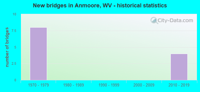
- New bridges - historical statistics
- 81970-1979
- 42010-2019


- Bridge Condition - Deck
- 37.5%Very good
- 12.5%Good
- 12.5%Satisfactory
- 37.5%Fair

- Bridge Condition - Superstructure
- 50.0%Very good
- 25.0%Good
- 25.0%Satisfactory

- Bridge Condition - Substructure
- 37.5%Very good
- 37.5%Good
- 25.0%Satisfactory

- Bridge Condition - Channel
- 16.7%Excellent
- 33.3%Very good
- 50.0%Good
Find on map >> Show street view
Structure Number: 17A255, Location: 0.44 MI SOUTH WV RT 58 (Lat: 39.251689, Lng: -80.284631), Route carried "on" structure: Interstate 7900, Year Built: 1973, Status: Open, Structure Length: 8.26m (27.10ft), Average Daily Traffic: 19,600 (year 2018), Truck Traffic: 20%, Average Future Daily Traffic: 28,425 (year 2038), Design Load: HS 20, Features Intersected: Har. Co. 23/9, Facility Carried by Structure: INTERSTATE 79 NB
Minimum Vertical Clearance: 30+ m (98+ ft), Kilometerpoint: 188.776, Lanes on structure: 2, Lanes under structure: 2, Base Highway Network: Yes, Owner: State Highway Agency, Approaching Roadway Width: 11.6m (38.1ft), Skew: 1 degrees, Material/Design: Steel continuous, Design/Construction: Stringer/Multi-beam, Number Of Spans In Main Unit: 1, Number Of Approach Spans: 2, Length of Maximum Span: 31.4m (103.0ft), Curb-To-Curb Width: 12.3m (40.4ft), Out-to-Out Width: 13.6m (44.6ft)
Condition: Deck: Fair, Superstructure: Satisfactory, Substructure: Satisfactory, Channel: Very good, Operating Rating: 47.2 metric tons, Method Used To Determine Operating Rating: Load Factor (LF), Inventory Rating: 28.1 metric tons, Method Used To Determine Inventory Rating: Load Factor (LF), Structural Evaluation: Equal to present minimum criteria, Deck Geometry: Better than present minimum criteria, Underclear: Equal to present minimum criteria, Waterway Adequacy: Superior to present desirable criteria, Approach Roadway Alignment: Better than present minimum criteria, Length Of Structure Improvement: 8.26m (27.10ft), Designated Inspection Frequency: Every 24 months, Inspection Date: January 2020, Bridge Improvement Cost: $693,000, Roadway Improvement Cost: $112,000, Total Project Cost: $1,075,000 ( Estimate for 2020), Deck Structure Type: Concrete Cast-file-Place, Wearing Surface/Protective System: Wearing Surface: Latex Concrete
Find on map >> Show street view
Structure Number: 17A256, Location: 0.44 MI SOUTH WV RT 58 (Lat: 39.251669, Lng: -80.284969), Route carried "on" structure: Interstate 7900, Year Built: 1973, Status: Open, Structure Length: 8.26m (27.10ft), Average Daily Traffic: 19,600 (year 2018), Truck Traffic: 20%, Average Future Daily Traffic: 28,425 (year 2038), Design Load: HS 20, Features Intersected: Har. Co. 23/9, Facility Carried by Structure: INTERSTATE 79 SB
Minimum Vertical Clearance: 30+ m (98+ ft), Kilometerpoint: 188.776, Lanes on structure: 2, Lanes under structure: 2, Base Highway Network: Yes, Owner: State Highway Agency, Approaching Roadway Width: 11.6m (38.1ft), Skew: 1 degrees, Material/Design: Steel continuous, Design/Construction: Stringer/Multi-beam, Number Of Spans In Main Unit: 1, Number Of Approach Spans: 2, Length of Maximum Span: 31.4m (103.0ft), Curb-To-Curb Width: 12.3m (40.4ft), Out-to-Out Width: 13.6m (44.6ft)
Condition: Deck: Fair, Superstructure: Satisfactory, Substructure: Satisfactory, Channel: Excellent, Operating Rating: 56.2 metric tons, Method Used To Determine Operating Rating: Load Factor (LF), Inventory Rating: 33.6 metric tons, Method Used To Determine Inventory Rating: Load Factor (LF), Structural Evaluation: Equal to present minimum criteria, Deck Geometry: Better than present minimum criteria, Underclear: Meets minimum limits, Waterway Adequacy: Superior to present desirable criteria, Approach Roadway Alignment: Better than present minimum criteria, Length Of Structure Improvement: 8.26m (27.10ft), Designated Inspection Frequency: Every 24 months, Inspection Date: January 2020, Bridge Improvement Cost: $681,000, Roadway Improvement Cost: $114,000, Total Project Cost: $1,086,000 ( Estimate for 2020), Deck Structure Type: Concrete Cast-file-Place, Wearing Surface/Protective System: Wearing Surface: Latex Concrete
Find on map >> Show street view
Structure Number: 17A257, Location: 1.52 MI SOUTH OF US 50 X (Lat: 39.257681, Lng: -80.286839), Route carried "on" structure: Interstate 7900, Year Built: 1973, Status: Open, Structure Length: 5.56m (18.24ft), Average Daily Traffic: 19,600 (year 2018), Truck Traffic: 20%, Average Future Daily Traffic: 28,425 (year 2038), Design Load: HS 20, Features Intersected: WV Rt 58, Facility Carried by Structure: INTERSTATE 79 NB
Minimum Vertical Clearance: 30+ m (98+ ft), Kilometerpoint: 189.484, Lanes on structure: 3, Lanes under structure: 4, Base Highway Network: Yes, Owner: State Highway Agency, Approaching Roadway Width: 20.1m (65.9ft), Material/Design: Steel continuous, Design/Construction: Stringer/Multi-beam, Number Of Spans In Main Unit: 1, Number Of Approach Spans: 2, Length of Maximum Span: 23.5m (77.1ft), Curb-To-Curb Width: 16.6m (54.5ft), Out-to-Out Width: 17.8m (58.4ft)
Condition: Deck: Fair, Superstructure: Good, Substructure: Good, Operating Rating: 63.5 metric tons, Method Used To Determine Operating Rating: Load Factor (LF), Inventory Rating: 38.1 metric tons, Method Used To Determine Inventory Rating: Load Factor (LF), Structural Evaluation: Better than present minimum criteria, Deck Geometry: Equal to present minimum criteria, Underclear: Meets minimum limits, Approach Roadway Alignment: Equal to present desirable criteria, Length Of Structure Improvement: 5.52m (18.11ft), Designated Inspection Frequency: Every 24 months, Inspection Date: January 2020, Bridge Improvement Cost: $715,000, Roadway Improvement Cost: $104,000, Total Project Cost: $1,078,000 ( Estimate for 2020), Deck Structure Type: Concrete Cast-file-Place, Wearing Surface/Protective System: Wearing Surface: Bituminous
Find on map >> Show street view
Structure Number: 17A258, Location: 1.52 MI SOUTH US RT 50 (Lat: 39.257781, Lng: -80.286461), Route carried "on" structure: Interstate 7900, Year Built: 1973, Status: Open, Structure Length: 5.56m (18.24ft), Average Daily Traffic: 19,600 (year 2018), Truck Traffic: 20%, Average Future Daily Traffic: 28,425 (year 2038), Design Load: HS 20, Features Intersected: WV Rt 58, Facility Carried by Structure: INTERSTATE 79 SB
Minimum Vertical Clearance: 30+ m (98+ ft), Kilometerpoint: 189.484, Lanes on structure: 3, Lanes under structure: 4, Base Highway Network: Yes, Owner: State Highway Agency, Approaching Roadway Width: 20.1m (65.9ft), Material/Design: Steel continuous, Design/Construction: Stringer/Multi-beam, Number Of Spans In Main Unit: 1, Number Of Approach Spans: 2, Length of Maximum Span: 23.5m (77.1ft), Curb-To-Curb Width: 16.6m (54.5ft), Out-to-Out Width: 17.8m (58.4ft)
Condition: Deck: Satisfactory, Superstructure: Good, Substructure: Good, Operating Rating: 63.5 metric tons, Method Used To Determine Operating Rating: Load Factor (LF), Inventory Rating: 38.1 metric tons, Method Used To Determine Inventory Rating: Load Factor (LF), Structural Evaluation: Better than present minimum criteria, Deck Geometry: Equal to present minimum criteria, Underclear: Meets minimum limits, Approach Roadway Alignment: Equal to present desirable criteria, Length Of Structure Improvement: 5.52m (18.11ft), Designated Inspection Frequency: Every 24 months, Inspection Date: January 2020, Bridge Improvement Cost: $725,000, Roadway Improvement Cost: $125,000, Total Project Cost: $1,047,000 ( Estimate for 2020), Deck Structure Type: Concrete Cast-file-Place, Wearing Surface/Protective System: Wearing Surface: Bituminous
Find on map >> Show street view
Structure Number: 17A349, Location: 0.05 mi W of Har Co 23/9 (Lat: 39.260200, Lng: -80.298389), Route carried "on" structure: State highway 58, Year Built: 2014, Status: Open, Structure Length: 2.85m (9.35ft), Average Daily Traffic: 5,800 (year 2018), Truck Traffic: 4%, Average Future Daily Traffic: 7,600 (year 2038), Design Load: HL 93, Features Intersected: Ann Moore Run
Minimum Vertical Clearance: 30+ m (98+ ft), Kilometerpoint: 3.830, Lanes on structure: 2, Owner: State Highway Agency, Approaching Roadway Width: 9.8m (32.2ft), Material/Design: Prestressed concrete, Design/Construction: Stringer/Multi-beam, Number Of Spans In Main Unit: 1, Length of Maximum Span: 27.6m (90.6ft), Curb or Sidewalk Widths: Left: 1.5m (4.9ft), Right: 0.0m, Curb-To-Curb Width: 9.1m (29.9ft), Out-to-Out Width: 11.4m (37.4ft)
Condition: Deck: Good, Superstructure: Very good, Substructure: Very good, Channel: Very good, Operating Rating: 71.7 metric tons, Method Used To Determine Operating Rating: Load and Resistance Factor (LRFR), Inventory Rating: 55.3 metric tons, Method Used To Determine Inventory Rating: Load and Resistance Factor (LRFR), Structural Evaluation: Equal to present desirable criteria, Deck Geometry: High priority of corrective action, Waterway Adequacy: Equal to present desirable criteria, Approach Roadway Alignment: Equal to present minimum criteria, Designated Inspection Frequency: Every 24 months, Inspection Date: July 2020, Deck Structure Type: Concrete Cast-file-Place, Wearing Surface/Protective System: Deck Protection: Epoxy Coated Reinforcing
Find on map >> Show street view
Structure Number: 17A353, Location: 0.18 mi S of Har Co 23/21 (Lat: 39.262600, Lng: -80.301600), Route carried "on" structure: County highway 239, Year Built: 2017, Status: Open, Structure Length: 1.23m (4.04ft), Average Daily Traffic: 6,400 (year 2018), Truck Traffic: 7%, Average Future Daily Traffic: 8,375 (year 2038), Design Load: HL 93, Features Intersected: Ann Moore Run, Facility Carried by Structure: Harr. Co. 23/9
Minimum Vertical Clearance: 30+ m (98+ ft), Kilometerpoint: 12.875, Lanes on structure: 2, Owner: State Highway Agency, Approaching Roadway Width: 10.4m (34.1ft), Material/Design: Prestressed concrete, Design/Construction: Box Beam or Girders - Single/Spread, Number Of Spans In Main Unit: 1, Length of Maximum Span: 11.6m (38.1ft), Curb-To-Curb Width: 10.2m (33.5ft), Out-to-Out Width: 11.1m (36.4ft)
Condition: Deck: Very good, Superstructure: Very good, Substructure: Very good, Channel: Good, Operating Rating: 66.2 metric tons, Method Used To Determine Operating Rating: Load and Resistance Factor (LRFR), Inventory Rating: 50.8 metric tons, Method Used To Determine Inventory Rating: Load and Resistance Factor (LRFR), Structural Evaluation: Equal to present desirable criteria, Deck Geometry: Meets minimum limits, Waterway Adequacy: Equal to present minimum criteria, Approach Roadway Alignment: Better than present minimum criteria, Designated Inspection Frequency: Every 48 months, Inspection Date: July 2020, Deck Structure Type: Other, Wearing Surface/Protective System: Deck Protection: Epoxy Coated Reinforcing
Find on map >> Show street view
Structure Number: 17A354, Location: 0.05 mi S of Har Co 23/21 (Lat: 39.263400, Lng: -80.303700), Route carried "on" structure: County highway 239, Year Built: 2017, Status: Open, Structure Length: 1.17m (3.84ft), Average Daily Traffic: 6,400 (year 2018), Truck Traffic: 7%, Average Future Daily Traffic: 8,375 (year 2038), Design Load: HL 93, Features Intersected: Ann Moore Run, Facility Carried by Structure: Har Co Rt 23/9
Minimum Vertical Clearance: 30+ m (98+ ft), Kilometerpoint: 13.084, Lanes on structure: 2, Owner: State Highway Agency, Approaching Roadway Width: 7.9m (25.9ft), Skew: 2 degrees, Material/Design: Prestressed concrete, Design/Construction: Box Beam or Girders - Multiple, Number Of Spans In Main Unit: 1, Length of Maximum Span: 11.0m (36.1ft), Curb or Sidewalk Widths: Left: 0.5m (1.6ft), Right: 0.5m (1.6ft), Curb-To-Curb Width: 9.1m (29.9ft), Out-to-Out Width: 10.2m (33.5ft)
Condition: Deck: Very good, Superstructure: Very good, Substructure: Good, Channel: Good, Operating Rating: 56.2 metric tons, Method Used To Determine Operating Rating: Load and Resistance Factor (LRFR), Inventory Rating: 43.5 metric tons, Method Used To Determine Inventory Rating: Load and Resistance Factor (LRFR), Structural Evaluation: Better than present minimum criteria, Deck Geometry: High priority of corrective action, Waterway Adequacy: Equal to present minimum criteria, Approach Roadway Alignment: Equal to present desirable criteria, Length Of Structure Improvement: 1.52m (4.99ft), Designated Inspection Frequency: Every 24 months, Inspection Date: April 2020, Deck Structure Type: Concrete Cast-file-Place
Find on map >> Show street view
Structure Number: 17A355, Location: 0.01 mi S of Har Co 23/14 (Lat: 39.264000, Lng: -80.306700), Route carried "on" structure: County highway 239, Year Built: 2017, Status: Open, Structure Length: 1.23m (4.04ft), Average Daily Traffic: 6,400 (year 2018), Truck Traffic: 7%, Average Future Daily Traffic: 8,375 (year 2038), Design Load: HL 93, Features Intersected: Ann Moore Run, Facility Carried by Structure: Harr. Co. 23/9
Minimum Vertical Clearance: 30+ m (98+ ft), Kilometerpoint: 13.325, Lanes on structure: 2, Owner: State Highway Agency, Approaching Roadway Width: 10.4m (34.1ft), Skew: 1 degrees, Material/Design: Prestressed concrete, Design/Construction: Box Beam or Girders - Single/Spread, Number Of Spans In Main Unit: 1, Length of Maximum Span: 11.6m (38.1ft), Curb-To-Curb Width: 9.4m (30.8ft), Out-to-Out Width: 10.4m (34.1ft)
Condition: Deck: Very good, Superstructure: Very good, Substructure: Very good, Channel: Good, Operating Rating: 62.6 metric tons, Method Used To Determine Operating Rating: Load and Resistance Factor (LRFR), Inventory Rating: 48.1 metric tons, Method Used To Determine Inventory Rating: Load and Resistance Factor (LRFR), Structural Evaluation: Equal to present desirable criteria, Deck Geometry: High priority of corrective action, Waterway Adequacy: Equal to present minimum criteria, Approach Roadway Alignment: Better than present minimum criteria, Designated Inspection Frequency: Every 24 months, Inspection Date: July 2020, Deck Structure Type: Other, Wearing Surface/Protective System: Deck Protection: Epoxy Coated Reinforcing
Find on map >> Show street view
Structure Number: 17A255, Location: 0.44 MI SOUTH WV RT 58 (Lat: 39.251669, Lng: -80.285000), Route carried "under" structure: County highway 2309, Year Built: 1973, Structure Length: 0. m, Average Daily Traffic: 1,700 (year 0018), Truck Traffic: 7%, Features Intersected: Har. Co. 23/9, Facility Carried by Structure: INTERSTATE 79 NB
Minimum Vertical Clearance: 17.43m (57.19ft), Kilometerpoint: 10.863, Lanes on structure: 2, Lanes under structure: 2, Length of Maximum Span: 31.4m (103.0ft)
Find on map >> Show street view
Structure Number: 17A256, Location: 0.44 MI SOUTH WV RT 58 (Lat: 39.251700, Lng: -80.284900), Route carried "under" structure: County highway 2309, Year Built: 1973, Structure Length: 0. m, Average Daily Traffic: 1,800 (year 0016), Truck Traffic: 7%, Features Intersected: Har. Co. 23/9, Facility Carried by Structure: INTERSTATE 79 SB
Minimum Vertical Clearance: 17.43m (57.19ft), Kilometerpoint: 10.863, Lanes on structure: 2, Lanes under structure: 2, Length of Maximum Span: 31.4m (103.0ft)
Find on map >> Show street view
Structure Number: 17A257, Location: 1.52 MI SOUTH OF US 50 X (Lat: 39.257800, Lng: -80.286461), Route carried "under" structure: State highway 5800, Year Built: 1973, Structure Length: 0. m, Average Daily Traffic: 5,300 (year 0018), Truck Traffic: 4%, Features Intersected: WV Rt 58, Facility Carried by Structure: INTERSTATE 79 NB
Minimum Vertical Clearance: 5.64m (18.50ft), Kilometerpoint: 5.086, Lanes on structure: 3, Lanes under structure: 4, Length of Maximum Span: 23.5m (77.1ft)
Find on map >> Show street view
Structure Number: 17A258, Location: 1.52 MI SOUTH US RT 50 (Lat: 39.257681, Lng: -80.286839), Route carried "under" structure: State highway 5800, Year Built: 1973, Structure Length: 0. m, Average Daily Traffic: 5,300 (year 0018), Truck Traffic: 4%, Features Intersected: WV Rt 58, Facility Carried by Structure: INTERSTATE 79 SB
Minimum Vertical Clearance: 6.00m (19.69ft), Kilometerpoint: 5.086, Lanes on structure: 3, Lanes under structure: 4, Length of Maximum Span: 23.5m (77.1ft)