Bridge Statistics for Andover, Massachusetts (MA)
Condition, Traffic, Stress, Structural Evaluation, Project Costs
- National Bridge Inventory (NBI) Statistics
- 12Number of bridges
- 69ft / 20.6mTotal length
- $16,349,000Total costs
- 226,660Total average daily traffic
- 7,299Total average daily truck traffic
- National Bridge Inventory (NBI) Registered Bridges for Andover
- No street view available for this location
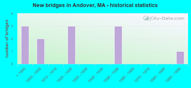
- New bridges - historical statistics
- 3Before 1900
- 21900-1909
- 31920-1929
- 31950-1959
- 11990-1999

- Reconstructed bridges - Historical Statistics
- 11910-1919
- 11920-1929
- 01930-1939
- 01940-1949
- 11950-1959
- 01960-1969
- 01970-1979
- 21980-1989
- 11990-1999
- 02000-2009
- 12010-2019


- Bridge Condition - Deck
- 57.1%Good
- 14.3%Satisfactory
- 28.6%Fair

- Bridge Condition - Superstructure
- 50.0%Good
- 40.0%Satisfactory
- 10.0%Fair

- Bridge Condition - Substructure
- 30.0%Good
- 50.0%Satisfactory
- 20.0%Fair

- Bridge Condition - Channel
- 57.1%Good
- 28.6%Satisfactory
- 14.3%Fair
Find on map >> Show street view
Structure Number: A090012YQDOTNBI, Location: .32 KM N ANDOVER CENTER (Lat: 42.664817, Lng: -71.146019), Route carried "on" structure: State highway 28, Year Built: 1879, Year Reconstructed: 1927, Status: Open, Structure Length: 1.28m (4.20ft), Average Daily Traffic: 20,100 (year 2020), Truck Traffic: 6%, Average Future Daily Traffic: 61,435 (year 2031), Features Intersected: WATER SHAWSHEEN RIVER
Minimum Vertical Clearance: 30+ m (98+ ft), Kilometerpoint: 234.234, Lanes on structure: 3, Base Highway Network: Yes, Owner: State Highway Agency, Approaching Roadway Width: 12.5m (41.0ft), Skew: 3 degrees, Material/Design: Masonry, Design/Construction: Arch - Deck, Number Of Spans In Main Unit: 1, Length of Maximum Span: 10.4m (34.1ft), Curb or Sidewalk Widths: Left: 2.6m (8.5ft), Right: 1.3m (4.3ft), Curb-To-Curb Width: 15.1m (49.5ft), Out-to-Out Width: 20.2m (66.3ft)
Condition: Deck: Fair, Superstructure: Satisfactory, Substructure: Satisfactory, Channel: Good, Operating Rating: 34.2 metric tons, Method Used To Determine Operating Rating: Allowable Stress (AS), Inventory Rating: 22.6 metric tons, Method Used To Determine Inventory Rating: Allowable Stress (AS), Structural Evaluation: Somewhat better than minimum adequacy, Deck Geometry: Equal to present minimum criteria, Waterway Adequacy: Equal to present desirable criteria, Approach Roadway Alignment: Equal to present desirable criteria, Length Of Structure Improvement: 1.30m (4.27ft), Designated Inspection Frequency: Every 24 months, Inspection Date: July 2020, Bridge Improvement Cost: $1,032,000, Roadway Improvement Cost: $104,000, Total Project Cost: $1,549,000 ( Estimate for 2022), Deck Structure Type: Concrete Cast-file-Place, Wearing Surface/Protective System: Wearing Surface: Bituminous
Find on map >> Show street view
Structure Number: A090032QKMUNNBI, Location: AT SHAWSHEEN RIVER (Lat: 42.647569, Lng: -71.150861), Route carried "on" structure: City street , Year Built: 1850, Year Reconstructed: 1993, Status: Open, Structure Length: 1.13m (3.71ft), Average Daily Traffic: 13,319 (year 2019), Truck Traffic: 5%, Average Future Daily Traffic: 18,683 (year 2032), Design Load: HS 20, Features Intersected: WATER SHAWSHEEN RIVER, Facility Carried by Structure: HWY CENTRAL ST
Minimum Vertical Clearance: 30+ m (98+ ft), Kilometerpoint: 0.016, Lanes on structure: 2, Owner: Town or Township Highway Agency, Approaching Roadway Width: 6.7m (22.0ft), Material/Design: Steel, Design/Construction: Stringer/Multi-beam, Number Of Spans In Main Unit: 1, Length of Maximum Span: 10.7m (35.1ft), Curb or Sidewalk Widths: Left: 1.6m (5.2ft), Right: 0.0m, Curb-To-Curb Width: 7.3m (24.0ft), Out-to-Out Width: 9.8m (32.2ft)
Condition: Deck: Good, Superstructure: Satisfactory, Substructure: Satisfactory, Channel: Good, Operating Rating: 43.7 metric tons, Method Used To Determine Operating Rating: Load Factor (LF), Inventory Rating: 39.1 metric tons, Method Used To Determine Inventory Rating: Load Factor (LF), Structural Evaluation: Equal to present minimum criteria, Deck Geometry: High priority of replacement, Waterway Adequacy: Superior to present desirable criteria, Approach Roadway Alignment: Meets minimum limits, Length Of Structure Improvement: 1.20m (3.94ft), Designated Inspection Frequency: Every 24 months, Inspection Date: August 2021, Bridge Improvement Cost: $691,000, Roadway Improvement Cost: $70,000, Total Project Cost: $1,037,000 ( Estimate for 2022), Deck Structure Type: Concrete Cast-file-Place, Wearing Surface/Protective System: Wearing Surface: Bituminous, Membrane: Built-up, Deck Protection: Epoxy Coated Reinforcing
Find on map >> Show street view
Structure Number: A090042QJMUNNBI, Location: 1 MI NE TEWKSBURY (Lat: 42.626578, Lng: -71.158661), Route carried "on" structure: City street , Year Built: 1900, Year Reconstructed: 1959, Status: Open, Structure Length: 1.91m (6.27ft), Average Daily Traffic: 4,691 (year 2019), Truck Traffic: 7%, Average Future Daily Traffic: 10,265 (year 2032), Design Load: H 20, Features Intersected: WATER SHAWSHEEN RIVER, Facility Carried by Structure: HWY ANDOVER ST
Minimum Vertical Clearance: 30+ m (98+ ft), Kilometerpoint: 1.658, Lanes on structure: 2, Owner: Town or Township Highway Agency, Approaching Roadway Width: 7.3m (24.0ft), Skew: 1 degrees, Material/Design: Steel, Design/Construction: Stringer/Multi-beam, Number Of Spans In Main Unit: 1, Length of Maximum Span: 18.3m (60.0ft), Curb or Sidewalk Widths: Left: 1.5m (4.9ft), Right: 1.5m (4.9ft), Curb-To-Curb Width: 7.3m (24.0ft), Out-to-Out Width: 11.0m (36.1ft)
Condition: Deck: Fair, Superstructure: Good, Substructure: Satisfactory, Channel: Good, Operating Rating: 51.2 metric tons, Method Used To Determine Operating Rating: Allowable Stress (AS), Inventory Rating: 30.4 metric tons, Method Used To Determine Inventory Rating: Allowable Stress (AS), Structural Evaluation: Equal to present minimum criteria, Deck Geometry: High priority of replacement, Waterway Adequacy: Superior to present desirable criteria, Approach Roadway Alignment: Meets minimum limits, Length Of Structure Improvement: 2.00m (6.56ft), Designated Inspection Frequency: Every 24 months, Underwater Inspection Frequency: Every 36 months, Inspection Date: May 2021, Underwater Inspection Date: June 2020, Bridge Improvement Cost: $865,000, Roadway Improvement Cost: $87,000, Total Project Cost: $1,298,000 ( Estimate for 2022), Deck Structure Type: Concrete Cast-file-Place, Wearing Surface/Protective System: Wearing Surface: Bituminous, Membrane: Built-up
Find on map >> Show street view
Structure Number: A090052QLMUNNBI, Location: .4 KM W. MAIN ST (Lat: 42.661981, Lng: -71.146583), Route carried "on" structure: City street , Year Built: 1900, Year Reconstructed: 1994, Status: Open, Structure Length: 1.43m (4.69ft), Average Daily Traffic: 6,200 (year 2018), Truck Traffic: 2%, Average Future Daily Traffic: 17,214 (year 2032), Design Load: HS 20, Features Intersected: WATER SHAWSHEEN RIVER, Facility Carried by Structure: HWY STEVENS ST
Minimum Vertical Clearance: 30+ m (98+ ft), Kilometerpoint: 0.402, Lanes on structure: 2, Owner: Town or Township Highway Agency, Approaching Roadway Width: 5.5m (18.0ft), Material/Design: Steel, Design/Construction: Stringer/Multi-beam, Number Of Spans In Main Unit: 1, Length of Maximum Span: 13.4m (44.0ft), Curb or Sidewalk Widths: Left: 0.0m, Right: 1.5m (4.9ft), Curb-To-Curb Width: 7.3m (24.0ft), Out-to-Out Width: 9.8m (32.2ft)
Condition: Deck: Good, Superstructure: Good, Substructure: Satisfactory, Channel: Satisfactory, Operating Rating: 57.5 metric tons, Method Used To Determine Operating Rating: Allowable Stress (AS), Inventory Rating: 37.2 metric tons, Method Used To Determine Inventory Rating: Allowable Stress (AS), Structural Evaluation: Equal to present minimum criteria, Deck Geometry: High priority of replacement, Waterway Adequacy: Superior to present desirable criteria, Approach Roadway Alignment: Equal to present desirable criteria, Length Of Structure Improvement: 1.50m (4.92ft), Designated Inspection Frequency: Every 24 months, Inspection Date: March 2021, Bridge Improvement Cost: $863,000, Roadway Improvement Cost: $87,000, Total Project Cost: $1,295,000 ( Estimate for 2022), Deck Structure Type: Concrete Cast-file-Place, Wearing Surface/Protective System: Wearing Surface: Bituminous, Membrane: Built-up, Deck Protection: Epoxy Coated Reinforcing
Find on map >> Show street view
Structure Number: A090062QMMUNNBI, Location: AT SHAWSHEEN RIVER (Lat: 42.657286, Lng: -71.146892), Route carried "on" structure: City street , Year Built: 1875, Year Reconstructed: 1918, Status: Open, Structure Length: 0.85m (2.79ft), Average Daily Traffic: 18,000 (year 2018), Truck Traffic: 3%, Average Future Daily Traffic: 24,637 (year 2031), Features Intersected: WATER SHAWSHEEN RIVER, Facility Carried by Structure: HWY ESSEX ST
Minimum Vertical Clearance: 30+ m (98+ ft), Kilometerpoint: 0.002, Lanes on structure: 2, Owner: Town or Township Highway Agency, Approaching Roadway Width: 9.4m (30.8ft), Material/Design: Masonry, Design/Construction: Arch - Deck, Number Of Spans In Main Unit: 1, Length of Maximum Span: 8.5m (27.9ft), Curb or Sidewalk Widths: Left: 2.2m (7.2ft), Right: 1.8m (5.9ft), Curb-To-Curb Width: 10.7m (35.1ft), Out-to-Out Width: 15.2m (49.9ft)
Condition: Superstructure: Fair, Substructure: Fair, Channel: Fair, Inventory Rating: 78.2 metric tons, Method Used To Determine Inventory Rating: Load Factor (LF), Structural Evaluation: Somewhat better than minimum adequacy, Deck Geometry: Meets minimum limits, Waterway Adequacy: Superior to present desirable criteria, Approach Roadway Alignment: Meets minimum limits, Length Of Structure Improvement: 0.90m (2.95ft), Designated Inspection Frequency: Every 24 months, Underwater Inspection Frequency: Every 36 months, Inspection Date: May 2020, Underwater Inspection Date: April 2019, Bridge Improvement Cost: $538,000, Roadway Improvement Cost: $54,000, Total Project Cost: $808,000 ( Estimate for 2022), Wearing Surface/Protective System: Wearing Surface: Bituminous
Find on map >> Show street view
Structure Number: A090072RQMUNNBI, Location: . 1 MILE EAST ST 28 (Lat: 42.671664, Lng: -71.149406), Route carried "on" structure: City street , Year Built: 1924, Status: Open, Structure Length: 1.07m (3.51ft), Average Daily Traffic: 2,450 (year 2018), Truck Traffic: 5%, Average Future Daily Traffic: 3,632 (year 2031), Features Intersected: WATER SHAWSHEEN RIVER, Facility Carried by Structure: HWY BALMORAL ST
Minimum Vertical Clearance: 30+ m (98+ ft), Kilometerpoint: 0.064, Lanes on structure: 2, Owner: Town or Township Highway Agency, Approaching Roadway Width: 11.0m (36.1ft), Skew: 2 degrees, Material/Design: Concrete, Design/Construction: Arch - Deck, Number Of Spans In Main Unit: 1, Length of Maximum Span: 10.7m (35.1ft), Curb or Sidewalk Widths: Left: 3.1m (10.2ft), Right: 3.1m (10.2ft), Curb-To-Curb Width: 10.9m (35.8ft), Out-to-Out Width: 18.2m (59.7ft)
Condition: Superstructure: Satisfactory, Substructure: Good, Channel: Satisfactory, Inventory Rating: 62.3 metric tons, Method Used To Determine Inventory Rating: Load Factor (LF), Structural Evaluation: Equal to present minimum criteria, Deck Geometry: Somewhat better than minimum adequacy, Waterway Adequacy: Better than present minimum criteria, Approach Roadway Alignment: Better than present minimum criteria, Length Of Structure Improvement: 1.10m (3.61ft), Designated Inspection Frequency: Every 24 months, Underwater Inspection Frequency: Every 36 months, Inspection Date: July 2020, Underwater Inspection Date: July 2020, Bridge Improvement Cost: $260,000, Roadway Improvement Cost: $27,000, Total Project Cost: $391,000 ( Estimate for 2022)
Find on map >> Show street view
Structure Number: A090082YUDOTNBI, Location: .1 MI N ST 28 (Lat: 42.672442, Lng: -71.149469), Route carried "on" structure: State highway 133, Year Built: 1921, Status: Open, Structure Length: 1.13m (3.71ft), Average Daily Traffic: 15,300 (year 2020), Truck Traffic: 8%, Average Future Daily Traffic: 43,905 (year 2031), Features Intersected: WATER SHAWSHEEN RIVER
Minimum Vertical Clearance: 30+ m (98+ ft), Kilometerpoint: 13.872, Lanes on structure: 2, Base Highway Network: Yes, Owner: State Highway Agency, Approaching Roadway Width: 11.0m (36.1ft), Material/Design: Concrete, Design/Construction: Arch - Deck, Number Of Spans In Main Unit: 1, Length of Maximum Span: 11.3m (37.1ft), Curb or Sidewalk Widths: Left: 3.3m (10.8ft), Right: 3.3m (10.8ft), Curb-To-Curb Width: 11.0m (36.1ft), Out-to-Out Width: 18.3m (60.0ft)
Condition: Superstructure: Good, Substructure: Good, Channel: Good, Operating Rating: 48.7 metric tons, Method Used To Determine Operating Rating: Load Factor (LF), Inventory Rating: 29.0 metric tons, Method Used To Determine Inventory Rating: Load Factor (LF), Structural Evaluation: Better than present minimum criteria, Deck Geometry: Meets minimum limits, Waterway Adequacy: Equal to present desirable criteria, Approach Roadway Alignment: Equal to present minimum criteria, Length Of Structure Improvement: 1.20m (3.94ft), Designated Inspection Frequency: Every 24 months, Underwater Inspection Frequency: Every 36 months, Inspection Date: July 2020, Underwater Inspection Date: December 2020, Bridge Improvement Cost: $863,000, Roadway Improvement Cost: $87,000, Total Project Cost: $1,295,000 ( Estimate for 2022)
Find on map >> Show street view
Structure Number: A09010AKBDOT634, Location: .2 MILES E ST 28 (Lat: 42.662653, Lng: -71.143097), Route carried "on" structure: State highway , Year Built: 1996, Status: Open, Structure Length: 1.43m (4.69ft), Average Daily Traffic: 7,800 (year 2016), Truck Traffic: 5%, Average Future Daily Traffic: 8,370 (year 2031), Design Load: HS 20, Features Intersected: RR MBTA/BMRR, Facility Carried by Structure: HWY HARDING ST
Minimum Vertical Clearance: 30+ m (98+ ft), Kilometerpoint: 0.338, Lanes on structure: 2, Owner: State Highway Agency, Approaching Roadway Width: 8.7m (28.5ft), Material/Design: Prestressed concrete, Design/Construction: Slab, Number Of Spans In Main Unit: 1, Length of Maximum Span: 14.0m (45.9ft), Curb or Sidewalk Widths: Left: 1.5m (4.9ft), Right: 1.5m (4.9ft), Curb-To-Curb Width: 8.5m (27.9ft), Out-to-Out Width: 12.3m (40.4ft)
Condition: Deck: Good, Superstructure: Good, Substructure: Good, Operating Rating: 67.5 metric tons, Method Used To Determine Operating Rating: Allowable Stress (AS), Inventory Rating: 40.5 metric tons, Method Used To Determine Inventory Rating: Allowable Stress (AS), Structural Evaluation: Better than present minimum criteria, Deck Geometry: High priority of replacement, Underclear: High priority of corrective action, Approach Roadway Alignment: Equal to present minimum criteria, Length Of Structure Improvement: 1.50m (4.92ft), Designated Inspection Frequency: Every 24 months, Inspection Date: November 2020, Bridge Improvement Cost: $693,000, Roadway Improvement Cost: $70,000, Total Project Cost: $1,040,000 ( Estimate for 2022), Deck Structure Type: Concrete Precast Panels, Wearing Surface/Protective System: Wearing Surface: Bituminous, Membrane: Built-up, Deck Protection: Epoxy Coated Reinforcing
Find on map >> Show street view
Structure Number: A09011331DOT634, Location: .4 MI N ANDOVER CENTER (Lat: 42.660917, Lng: -71.143731), Route carried "on" structure: State highway 28, Year Built: 1929, Year Reconstructed: 2018, Status: Open, Structure Length: 2.54m (8.33ft), Average Daily Traffic: 22,800 (year 2018), Truck Traffic: 5%, Average Future Daily Traffic: 35,692 (year 2032), Design Load: HL 93, Features Intersected: RR MBTA/BMRR
Minimum Vertical Clearance: 30+ m (98+ ft), Kilometerpoint: 232.797, Lanes on structure: 3, Base Highway Network: Yes, Owner: State Highway Agency, Approaching Roadway Width: 14.0m (45.9ft), Skew: 15 degrees, Material/Design: Steel, Design/Construction: Stringer/Multi-beam, Number Of Spans In Main Unit: 1, Length of Maximum Span: 24.3m (79.7ft), Curb or Sidewalk Widths: Left: 1.6m (5.2ft), Right: 1.6m (5.2ft), Curb-To-Curb Width: 14.0m (45.9ft), Out-to-Out Width: 18.2m (59.7ft)
Condition: Deck: Good, Superstructure: Good, Substructure: Satisfactory, Operating Rating: 94.0 metric tons, Method Used To Determine Operating Rating: Load and Resistance Factor Rating (LRFR) rating reported by rating factor(RF) method using HL-93 loadings, Inventory Rating: 71.3 metric tons, Method Used To Determine Inventory Rating: Load and Resistance Factor Rating (LRFR) rating reported by rating factor(RF) method using HL-93 loadings, Structural Evaluation: Equal to present minimum criteria, Deck Geometry: Somewhat better than minimum adequacy, Underclear: High priority of corrective action, Approach Roadway Alignment: Equal to present minimum criteria, Designated Inspection Frequency: Every 24 months, Inspection Date: August 2021, Deck Structure Type: Concrete Cast-file-Place, Wearing Surface/Protective System: Wearing Surface: Integral Concrete
Find on map >> Show street view
Structure Number: A090262YVDOTNBI, Location: 1.2 MI S I 495 (Lat: 42.646197, Lng: -71.186075), Route carried "on" structure: State highway 133, Year Built: 1959, Year Reconstructed: 1990, Status: Open, Structure Length: 7.83m (25.69ft), Average Daily Traffic: 26,000 (year 2018), Truck Traffic: 6%, Average Future Daily Traffic: 37,587 (year 2031), Design Load: H 20, Features Intersected: I 93
Minimum Vertical Clearance: 30+ m (98+ ft), Kilometerpoint: 9.384, Lanes on structure: 2, Lanes under structure: 6, Base Highway Network: Yes, Owner: State Highway Agency, Approaching Roadway Width: 15.8m (51.8ft), Skew: 2 degrees, Material/Design: Steel continuous, Design/Construction: Stringer/Multi-beam, Number Of Spans In Main Unit: 4, Length of Maximum Span: 26.5m (86.9ft), Curb or Sidewalk Widths: Left: 0.2m (0.7ft), Right: 1.5m (4.9ft), Curb-To-Curb Width: 13.8m (45.3ft), Out-to-Out Width: 16.4m (53.8ft)
Condition: Deck: Satisfactory, Superstructure: Satisfactory, Substructure: Fair, Operating Rating: 67.5 metric tons, Method Used To Determine Operating Rating: Load Factor (LF), Inventory Rating: 40.4 metric tons, Method Used To Determine Inventory Rating: Load Factor (LF), Structural Evaluation: Somewhat better than minimum adequacy, Deck Geometry: Superior to present desirable criteria, Underclear: High priority of corrective action, Approach Roadway Alignment: Equal to present desirable criteria, Length Of Structure Improvement: 7.90m (25.92ft), Designated Inspection Frequency: Every 24 months, Inspection Date: November 2020, Bridge Improvement Cost: $5,090,000, Roadway Improvement Cost: $510,000, Total Project Cost: $7,636,000 ( Estimate for 2022), Deck Structure Type: Concrete Cast-file-Place, Wearing Surface/Protective System: Wearing Surface: Latex Concrete, Deck Protection: Epoxy Coated Reinforcing
Find on map >> Show street view
Structure Number: A090262YVDOTNBI, Location: 041188 STATUTORY (Lat: 42.650000, Lng: -71.183333), Route carried "under" structure: Interstate 93, Year Built: 1959, Structure Length: 0. m, Average Daily Traffic: 45,000 (year 0000), Features Intersected: I 93 SB, Facility Carried by Structure: ST133 LOWELL ST
Minimum Vertical Clearance: 4.78m (15.68ft), Kilometerpoint: 63.749, Lanes on structure: 3, Lanes under structure: 3, Material/Design: Steel, Design/Construction: Stringer/Multi-beam, Length of Maximum Span: 26.5m (86.9ft)
Find on map >> Show street view
Structure Number: A090262YVDOTNBI, Location: 041188 STATUTORY (Lat: 42.650000, Lng: -71.183333), Route carried "under" structure: Interstate 93, Year Built: 1959, Structure Length: 0. m, Average Daily Traffic: 45,000 (year 0000), Features Intersected: I 93 NB, Facility Carried by Structure: ST133 LOWELL ST
Minimum Vertical Clearance: 4.78m (15.68ft), Kilometerpoint: 63.749, Lanes on structure: 3, Lanes under structure: 3, Material/Design: Steel, Design/Construction: Stringer/Multi-beam, Length of Maximum Span: 26.5m (86.9ft)